ANDREJ PRELOŽNIK – ALEKSANDRA NESTOROVIĆ
BETWEEN METROPOLIS AND WILDERNESS:
THE TOPOGRAPHY OF MITHRAEA IN AGER POETOVIENSIS
Summary: Traces of Mithraism in Slovenia are represented by a large number of Mithraea and finds of altars and stones carved with Mithraic symbols. Some of these have been systematically studied and are quite well-known, others are poorly documented and less known. This difference is largely a consequence of factors from antiquity, such as the social status of the dedicators of the monuments and the choice of the location.
Our contribution focuses on the location of these shrines in north-eastern Slovenia, especially at Drava Plain and Ager of Poetovio, one of the most important Mithraic centres. The questions we explore are: where and in what environment were Mithraea built; what is their relationship to other urban struc- tures, traffic routes, natural resources and topography; and what role do they have in their setting within provincial and city boundaries.
The results of our analysis show the heterogeneity of responses to these questions and, consequently, the vitality of the cult of Mithras in the study area.
Key words: Mithraeum, Mithras, topography, urban Mithraea, countryside Mithraea, Pannonia, ager, Poe- tovio, Ptuj, Slovenia, Pannonia
Slovenia lies between the Gulf of Trieste, which represents the extreme northern part of the Adriatic Sea, and the Pannonian Plain. Hilly countryside, representing the ma- jority of its territory, is crossed from the west to the east by the Sava and Drava rivers, creating in this way the two main communication routes. From the south-west to the north-east runs the shortest connection between Northern Italy and the Pannonian low- land, representing from the prehistoric times onwards the so-called Amber Route. In Ro- man times, it equated to the main road Aquileia – Emona – Celeia – Poetovio and on- wards towards Aquincum or Carnuntum. Another main route leads from Ljubljana to- wards the east (Emona – Siscia – Sirmium). The area of today’s Slovenia was part of three Roman administrative units: the tenth region of Italy, Noricum and Pannonia.
Poetovio (today’s Ptuj) has long been universally recognized as one of the most im- portant centres of Mithraism. Of course, it is not the only location of the Mithras cult
276 ANDREJ PRELOŽNIK – ALEKSANDRA NESTOROVIĆ
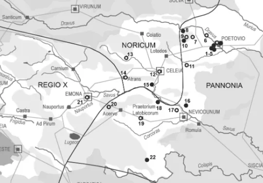
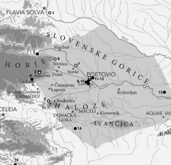
in Slovenia.1 Currently, 22 are known – of which five are in Ptuj. Almost half of them are cult places in situ, while in other cases monuments are in a secondary position but most likely originate from a location in the immediate vicinity. The number of sites is sufficient that their mapping allows some impression about the prevalence of the cult. The vast majority of them are concentrated between the rivers Drava and Sava, which is (approximately) the north-eastern part of Slovenia. North of the Drava basin they are currently not known, south of the Sava (and its immediate shoreline) only four, and west of Ljubljana none at all. Monuments of the Mithras cult are found again only in the immediate vicinity of the sea, from Aquileia through Duino/Devin to Mug- gia/Milje and in Istria, in all cases already beyond today’s political borders (fig. 1).
Even the distribution according to Roman administrative units is interesting: leading the list is Pannonia with the vast majority of monuments and sites. It is best repre- sented by the ager of Poetovio, fewer are located in the area of Neviodunum. In the Slovenian part of Noricum (ager of Celeia) we know four locations (only one with the monument in situ), while in the area of Emona (then part of Italy) only one monu- ment in secondary position is known.
Most of the locations have been known for a long time and monuments have been published and iconographically and epigraphically evaluated. Less known is the topographic aspect of these sites. Since many sites were discovered by chance and poorly documented, such data is very sparse. Depending on circumstances, the exact locations of some sites are no more recognizable or unknown. However, today we can highlight them with new, more illuminating approaches. These latter mainly de- pend on airborne laser scanning (LIDAR), which gives a good insight into the terrain of the site and for information about other new nearby archaeological sites that can better define their context.
In general, the sites with Mithraic monuments can be divided into two groups:
those in the urban environment and those located in the countryside. Locations of the first group were adapted to the urban environment and probably could not differ greatly from the settings of other sanctuaries. The second group, however, shows a much more deliberate choice of the area, both in relation to other structures of the cul- tural landscape as well as the natural conditions. Less expressive, of course, are the locations with secondary displays of monuments. Nevertheless, these also, directly or indirectly, allow certain conclusions.
The area with the densest concentration of Mithraic monuments in Slovenia is the Drava plain and its outskirts, which covers the area between Ptuj in the east, the Drava in the north, the slopes of Pohorje mountain to the west and the Dravinja river in the south. Two state roads cross this triangular plain that leads from Celeia to Poetovio and to Flavia Solva. It is, of course, the area of influence of Poetovio,
1 SELEM,P.: Mithrin kult u Panoniji [Der Mithrakult in Pannonien]. Radovi 8 (1976) 5–63; KORO- ŠEC,J.: Ocena stanja dediščine mitraizma v slovenskem prostoru [Werturteil des mithraischen Erbes im slowenischen Raum]. In VOMER GOJKOVIČ,M.–KOLAR, N.(eds): Ptuj v rimskem cesarstvu, mitraizem in njegova doba Archaeologia Poetovionensis 2. Ptuj, 11–15. oktober 1999. Ptuj 2001, 371–382.
Fig. 1. Mithraic monuments in Slovenia. ● original position or Mithraeum, ○ secondary position.
1–5 Ptuj, 6 Vurberg, 7 Hoče, 8 Ruše, 9 Šmartno, 10 Modrič, 11 Poljčane, 12 Celje, 13 Šentjanž, 14 Troja- ne, 15 Malič, 16 Zgornja Pohanca, 17 Krško, 18 Log pri Sevnici, 19 Trebnje, 20 Pristava pri Višnji Gori, 21 Ljubljana, 22 Rožanec (cartography © A. Preložnik)
which received water and raw materials from Pohorje (marble, wood, possibly iron ore). As there are both urban and countryside locations in relative proximity, this area seems a good test case for topographic evaluation.
Poetovio had an excellent geo-strategical position. It spread out on both sides of the Drava River along the main road from Italy to Pannonia, which used a long- known easy passage across the river. It was settled from the prehistory and gradually developed into one of the most flourishing cities in the province of Pannonia.At the time of its greatest prosperity the city had a longitudinal form around 3.5 kilometres in length, following the main road, and had about 40.000 inhabitants.2
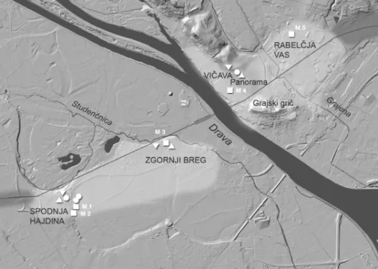
Various urban parts may be distinguished (fig. 2). The western part of Poetovio on the right bank of the Drava River expanded across two river terraces. Vicus Fortunae
2For topography, see: HORVAT,J. ET AL.: Poetovio Development and Topography. In ŠAŠEL KOS,M.–SCHERRER,P. (eds): The Autonomous Towns of Noricum and Pannonia [Situla 41]. Ljubljana 2003, 153–189; ŠAŠEL KOS,M.: Poetovio before the Marcomannic Wars from Legionary Camp to Colo- nia Ulpia. In PISO,I.–VARGA,R. (eds): Trajan und seine Städte: Colloquium, Cluj-Napoca, 29. Septem- ber – 2. Oktober 2013. Cluj-Napoca 2014, 139–165.
278 ANDREJ PRELOŽNIK – ALEKSANDRA NESTOROVIĆ
Fig. 2. Topography of Poetovio with locations of Mithraeums and others main sanctuaries.
■ – Mithra, ▼– Jupiter, ▲ – Nutrices, ● – others (Cartography © GURS, Atlas okolja)
– the business-commercial quarter with forum, warehouses, administration buildings and temples – was on the upper terrace (the western part of today’s Spodnja Hajdi- na). On the lower terrace (today’s Zgornji Breg) urban villas were situated. Both parts were situated south of the main road which ran on the edge of terrace, crossing the then course of the river and continuing to the left bank (today’s Vičava). Here we can assume the location of the city centre, subjected to heavy destruction with the movement of the riverbed to the north. Afterwards, the road continued through the passage between Panorama and Grajski grič (“Castle Hill”), across the Grajena stream and through the eastern industrial suburbia (today’s Rabelčja vas) in the direc- tion of north-east.
Based on the temples and monuments which have been discovered, we can con- clude that there were at least five Mithraea, three of which were found in situ and studied extensively. Although all Poetovian Mithraea are urban, they are quite hetero- geneous considering their topographic position.
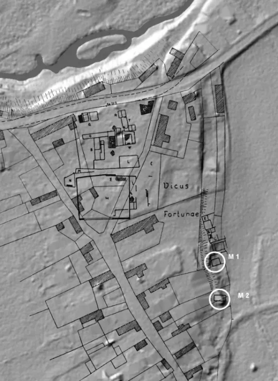
Two Mithraea were situated just below the edge of the second terrace on which Vicus Fortunae is situated, partly dug into the slope that divides upper and lower ter- race.
In the vicinity of the Mithraeum, there is a water spring enclosed by a wall, a large hall and a series of small sanctuaries dedicated to Vulcan and to Venus as well as to two other unidentifiable deities. Dedication stones to Mar(i)mogius and the Holy
spring and Nymphs were discovered approximately 100 m north of the First Mith- raeum. They probably originated from the same complex.3
The main road Celeia–Poetovio–Savaria passed approximately 200 m north of the Mithraea. As Vicus Fortunae represents the westernmost part of town, the western necropolis starts in the vicinity. Furthermore, a smaller cemetery is also located in the immediate vicinity of the Mithraea. It is dated from the 1st to the 3rd century, so it must be partly concurrent with the Mithraea, but the relationship between the graves and the cult objects is not clear (fig. 3).
The First Mithraeum is the oldest and the smallest of those in Poetovio. It was con- structed in the mid-2nd century and it was in use until the 4th century. The Mithraeum is oriented east-west, with entrance on the east side; its dimensions were approxi- mately 7×9 m. The building had rectangular floor plan, a narrow elongated area in front of the entrance and a smaller space (treasury?) north of it. The ground is covered with compacted soil. On the left and right sides rise two podia. Dedications from Illyrian customs officials were uncovered here, dating to the years 150–180.
An empty area with three water wells was discovered south of the First Mithraeum.
The Second Mithraeum was built later atop the spring just beyond the water wells, approximately 20 m away from the First Mithraeum. The Second Mithraeum, dating from the beginning of the 3rd century was built during the reign of Septimius Severus and was still in use during the first half of the 4th century (AIJ 299–310).
The last coins found within the enclosed spring are from the reign of Constantius II (323–361). The Mithraeum was oriented east-west, with the entrance on the east; its dimensions were approximately 13.7×7.3 m. The rectangular shrine was divided into three parts, the central part and two podia. The surface was mostly covered with lime mortar. A stone wall with a threshold divided the space into a small pronaos (one third of the space) and the naos. In front of the western wall, which marks the end of the naos, was the structure with a convex part on which the cult relief was erected.
On the right side of the passage, partly leaning towards the right podium, a fenced holy spring (fons perennis) was located. Next to it stood an altar dedicated to the holy spring, which is older than the other monuments. This means that the holy spring could have previously belonged to the First Mithraeum. Dedications from customs officials were present in this sanctuary as well.
A similar situation, orientation and close proximity, together with iconographic, epigraphic and chronological data allow the assumption that both Mithrea belong to the same Mithraic community, which expanded its cult area over time.
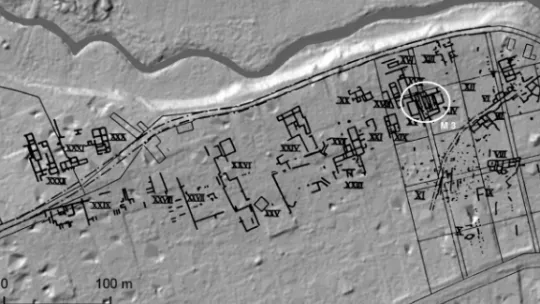
The Third Mithraeum is the biggest of all known Poetovian Mithraea. It is situated in the quarter of luxurious urban villas. It was built in the immediate vicinity of a large and luxurious villa and perhaps belonged to its estate (fig. 4).4
3For history of excavations and older literature, see: VOMER GOJKOVIČ,M.–DJURIĆ,B.–LOVE- NJAK,M.: Prvi petovionski mitrej na Spodnji Hajdini [First Mithraeum in Poetovio]. Ptuj 2011.
4 For history of excavations and older literature, see: VOMER GOJKOVIČ,M.: Tretji petovionski mit- rej [Third Mithraeum in Poetovio]. Ptuj 2015.
280 ANDREJ PRELOŽNIK – ALEKSANDRA NESTOROVIĆ
Fig. 3. Vicus Fortunae in Spodnja Hajdina after Schmid with locations of the First and Second Mithraeum (Cartography © GURS, Atlas okolja)
Fig. 4. Zgornji Breg after Jenny with location of the Third Mithraeum (Cartography © GURS, Atlas okolja)
The rectangular shrine is oriented north-south with the entrance on the south.
At least two building phases were detected. The older shrine measuring 11.2×6.85 m with 3 m wide entrance hall at the front, was expanded during the second half of the 3rd century to 16×8 m. The central part is paved with brick. The podia are covered with compacted soil. West of the building a channel for fresh water for rituals was found. Dedications from the officers of the V Macedonica and XIII Gemina legions during the reign of the emperor Gallienus (259–268) pertain to the second building phase. Parts from the relief of the main cult image were also preserved. A room leans against the eastern side of Mithraeum in which the bust of a goddess was discovered.
Probably it was a temple of Nutrices or maybe the temple of Mater Magna.5 The build- ings in the area were abandoned before the end of the 4th century.
Various Mithraic monuments are known from the area between the castle hill and Vičava and are ascribed to the so-called Fourth Mithareum. Some are reported as spoliae built into medieval structures (monastery, town wall tower), others are chance finds from excavations and renovation work within a distance of some 500 meters.6
5 HORVAT ET AL. (n. 2) 178.
6 MIKL,I.: Petovijski četrti mitrej [Fourth Mithraeum in Poetovio]. In ANŽEL,F. (ed.): Ptujski zbor- nik 2: 1942–1962. Ptuj 1962, 212−218; ŠUBIC,Z.: Epigrafske najdbe v Ptuju in območju v letih 1965–
1966 [Epigraphische Neufunde aus Poetovio und Umgebung (1965–1966)]. Arheološki vestnik 18 (1967) 187–191; ŠUBIC,Z.: Novi rimski napisi iz Poetovione (1968–1972) [Neue römische Inschriften aus Poe- tovio (1968–1972)]. Arheološki vestnik 28 (1977) 91–100; LUBŠINA TUŠEK,M.: Elaborat k predlogu za razglasitev arheološkega najdišča Panorama na Ptuju za kulturni spomenik državnega pomena [Study on the Proposal for the Proclamation Act of the Archaeological Site of Panorama in Ptuj as a Cultural Monument of National Importance]. Ptuj 2015, 40, 60–62, 151, 153, 213–214.
282 ANDREJ PRELOŽNIK – ALEKSANDRA NESTOROVIĆ
Fig. 5. Vičava with locations of Mithraic monuments in secondary position, possibly from the Fourth Mithraeum or sanctuary of Sol (Cartography © GURS, Atlas okolja)
Not a single one, however, was found in its original primary setting. That is why it is impossible to say from which sanctuary they came and if they belong to one or more of them. On Panorama hill, north of Vičava various cult objects are known or sup- posed, among them sanctuaries of Jupiter and the Lunar Goddess (fig. 5).
To the Mithras cult belong remains of altars dedicated to D S I M, a relief with tauroctony and a memorial plate commemorating the renovation of the Mithraeum.
When first discovered, a relief with a depiction of Sol was also considered as part of this supposed Fourth Mithraeum, but it is also possible that it was the main cult image of sanctuary of Sol Invictus or Lunar Goddess, as the iconography resembles those from lead plaques of “Danubian Horsemen”. In addition, one of the “old” monuments (CIL III 4040) is also dedicated to Sol Sacrum.
With its exact location still unknown we can only assume that Fourth Mith- raeum stood in the city centre or its immediate vicinity and was, as CIL III 4039 attest, renovated at the beginning of the 4th century. Considering that the area was densely populated and built, we can speculate that this Mithraeum could not be iso- lated. Perhaps sanctuary precinct similar to that in Vicus Fortunae in Spodnja Hajdina (First and Second Mithraeum) could be expected – even partly dug-in architecture would be possible because of the nearby Castle and Panorama hills.
Industrial activities were highly concentrated in the eastern part of Poetovio, in pre- sent-day Rabelčja vas. Workshops of pottery and bricks were predominant. The monuments of the Fifth Mithraeum are the most distinctive remains that belong to the cult in this industrial quarter. They were discovered at the northern edge of the Roman settlement, approximately 250 m away from the main road.7 Broken parts of marble pillars, altars, marble slabs with inscriptions and reliefs and an altar dedicated to the Sol and Mithras were discovered in a pit that was dug through poorly preserved foundations measuring 8×6 m. It is not clear whether this building was actually the Mithraic shrine.
The building is oriented northwest-southeast, the same as the structures and bur- ial plots 20 m away. These graves within the burial plots are dated from 2nd to the be- ginning of 5th century. Twenty m to the west and north-west there was an area with pottery kilns, maybe belonging to the same workshop. The monuments could have been deposited in the pit as recycling material, but most probably the shrine was in the vicinity. The inscription on the altar of white marble dates to 235. According to the stone monuments and coins found with them the sanctuary was in use from the 3rd to the 4th century.8
A dedicatory altar (CIL III 4042) was in the original publication listed as one from Ptuj. But Saria identified it in 1933 on the basis of Povoden’s notes with the monument seen by the pharmacist Hauscha already in 1827 at Vurberk.9 The stone was already in a secondary position. Vurberk is in an exposed location just above the
7 TUŠEK, I.: Peti mitrej v Ptuju. Arheološki vestnik 41. Ljubljana 1990, 267–275; TUŠEK, I.: Peti mitrej na Ptuju. In: M. VOMER GOJKOVIČ,N.KOLAR (eds): Ptuj v rimskem cesarstvu, mitraizem in nje- gova doba. Archaeologia Poetovionensis 2. Ptuj 2001, 191–221.
TUŠEK,I.: Peti mitrej v Ptuju [Das fünfte Mithräum in Ptuj]. Arheološki vestnik 41 (1990) 267–
275; Tušek, I.: Peti mitrej na Ptuju [Das fünfte Mithräum in Ptuj]. In VOMER GOJKOVIČ–KOLAR (n. 1) 191–221.
8HORVAT,J.–DOLENC VIČIČ,A.: Archaeological sites of Ptuj. Rabelčja vas [Opera Instituti Ar- chaeologici Sloveniae 20]. Ljubljana 2010, 209.
9 SARIA,B.: Nova raziskavanja po stari Poetoviji [Neue Intersuchungen auf dem Gebiete von Poe- tovio]. Časopis za zgodovino in narodopisje 28 (1933) 127–128.
284 ANDREJ PRELOŽNIK – ALEKSANDRA NESTOROVIĆ
Fig. 6. Ruše plain with position of the Mithraeum, settlement and necropolis (Cartography © GURS, Atlas okolja)
Drava River, approximately between Ptuj and Maribor. From here, one of the Poeto- vio aqueducts was fed, in the hinterland the typical stone was quarried – the location was therefore well known to the Romans. Another possibility is that the altar comes from Starše on the south bank of the Drava River, where there were discovered many Roman stones but probably also already in the secondary position and use.
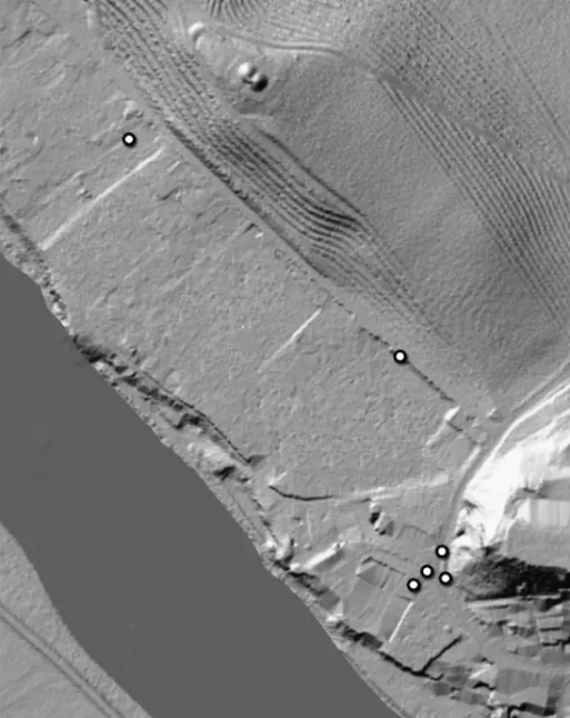
Ruše is a small town located at the end of the plain, which runs from Maribor to the west between the slopes of Pohorje and the Drava riverbed. West from Ruše where the plain ends, Drava Valley closes into a narrow gorge. The place is famous for a prehistoric settlement and cemetery (fig. 6).
The Ruše shrine was discovered by chance in 1845.10 After the discovery of the sanctuary’s panels depicting the tauroctony quite unscientific excavations were initiated partly under the direction of the historian from near-by Maribor, J. Puff in 1845 and 1847. Documents are not preserved or known. According to data, which were later collected by A. Müllner and resumed by Skrabar, a shrine had dimensions of approx. 3.2×5.5 m, partially buried in the hill and arched, located approx. 5.7 m
10 SKRABAR,V.: Ruški mitrej [Mithraeum in Ruše]. Časopis za zgodovino in narodopisje 17 (1922) 15–20.
above the surface of the Drava River. At the entrance there was a stone threshold of 1.6×0.4×0.2 m. The main panel, 4 small votive pannels, 4 cipi-altars (with rosettes and bull heads), oil lamps, coins, bones, burnt earth, and coins ranging mainly from Maximinus Thrax to Diocletian were discovered.
The exact location is not clear, because the river was later dammed and an arti- ficial lake came about, which flooded the location. However, it is clear that the shrine was on the shore, probably parallel with the river. In the vicinity, the Ruše stream carved a deep gorge through the terrace and mouth into the Drava.
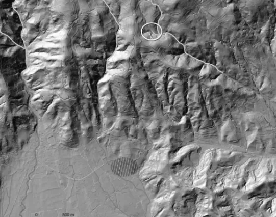
About a mile to the west of the shrine Roman tumuli necropolis are located, near the Pohorje mountains; in the middle of the plain Roman buildings can be seen that belong to the vicus or a villa rustica. Not far from the Mithraeum is the location of the medieval ferry and at the same place the Roman road is likely to cross the river, as there is not enough space for it on the steep slope of the left bank. The shrine, there- fore, was on the highly prominent position: the end of the gorge, crossing over the river, at the mouth of a torrential stream – clearly visible by travellers passing.11 Another shrine was discovered on the southern slopes of Pohorje, in Modrič. Its dis- covery was more or less accidental. Stone monuments were disclosed by the major rainfall torrential waters. In August 1893 Ferk and Malenšak collected and partially excavated several relief and inscription plates and altars. A few stones were discov- ered earlier and transferred to the house of the landowner and at least another two pieces were transferred later (1914, 1920). They also refer to the figures which were lost. Ferk published just a note and the finds were published thirty years later by Skrabar (1924).12 Only the generic location is ascertained: one among the torrential streams which discharge water from the Pohorje slope towards the Drava plain. Rem- nants of stone or wooden architecture are not known. Also, it is not clear if the monu- ments were found on location of Mithraeum, since it was due to the water that they were discovered, or even transferred from the original position. Although Skrabar was convinced that the find spot is far from being thoroughly investigated, the trial trenches B. Saria made there in August 1921 did not yield any significant results.
At the foot of the Pohorje the Roman road led, about 4 km from the location of the
“white city”, to the alleged settlement or roadside station in Čadram. The ridge west of Malič Ferk approximately corresponds to the “Roman way”, which went through Kebelj to Pohorje. That the area was inhabited in Roman times is shown by some common Roman monuments built as spolia into the churches in Kebelj and Tinje, two nearby locations at a 2 to 3 km distance to the Mithraeum (fig. 7).13
11PAHIČ,S.: Ruški kraj v rimski dobi [Ruše in the Roman Era]. In Ruška kronika. Maribor 1985, 43–67.
12 SKRABAR,V.: Das Mithraeum bei Modrič am Bachergebirge. In BULIĆ,F.–ABRAMIĆ,M.– HOFFILLER, V. (eds): Bulićev zbornik / Strena Buliciana. Split 1924, 151–160; PAHIČ,S.: Seznam rim- skih kamnov v Podravju in Pomurju [Verzeichnis der Römerstelle im Slowenischen Drauland]. Arheo- loški Vestnik 28 (1977) 51–52.
13 PAHIČ,S.: Bistriški svet v davnini [Bistrica and its Surroundings in the Ancient Times]. Zbor- nik občine Slovenska Bistrica 1 (1984) 39–90.
286 ANDREJ PRELOŽNIK – ALEKSANDRA NESTOROVIĆ
Fig. 7. Pohorje slopes with position of the Modrič Mithraeum, settlement remains in Čadram and secondary positions of Roman monuments at Kebelj and Tinje
(Cartography © GURS, Atlas okolja)
On the edge of the Drava plain three secondary locations of Mihtraic monuments are also known. These three cases are noteworthy for their early, perhaps pre-Roman- esque churches in which Roman stones were built-in apparently during their con- struction. This points to a proximity of the ruins or the original location of the monu- ments.
Šmartno is located within the Pohorje marble key beds. This was a main settlement of Roman stonecutters. The church is an important monument of Romanesque archi- tecture with several Roman monuments built-in, among whom the votive relief with Mithras tauroctonos is an evident proof of a Mithraic cult practiced in this part of Po- horje. Concerning the dedicants, it is assumed that they belonged to a family of stone- masons.14
14 PAHIČ,S.: Seznam rimskih kamnov (n. 12) 59; PAHIČ,S.: Neue römische Inschriften im slowe- nischen Drauland. Arheološki Vestnik 28 (1977) 74–91.
The church of the Saint George in Hoče is a primal parish church built near the ruins of a Roman settlement and a Roman road. An altar to Mithras had been reused in the crypt under the church.15
A Mithraic altar from Poljčane is connected to the local original church, since it was reused as a basis for the inscription of Iring, founder of the early church.16 Poljčane is situated at the northern foot of the Boč mountain, and controls the passage through the massif of Haloze to the Sotla river valley.
The distance of the sites presented in this paper from Poetovio is approximately 30 km.
Some 30 to 40 km from the contemporary Ptuj to the south and east two more Mith- raic cultic sites have been identified, both located in Croatia. We mention them in or- der to implement the panorama.
In 1941 a relief with the tauroctony has been found by chance in Donja Ple- menšćina near Pregrade by a local farmer, during works in a vineyard. No other find is reported. Interestingly, vineyard “Gromlja” was located on the steep slope flanking a small creek. Šeper hypothesized that the stone came from some buildings on the plateau above the vineyard.17
In the archaeological museum of Zagreb an additional fragment allegedly from Pregrade is kept, but without any related datum.18 That is the reason why no conclu- sion can be drawn about connections between the monument and the site.
In 1997 during the extaction of gravel in the watered gravel pit in Poleve near Čako- vec two altars dedicated to Cautes and Cautopates were uncovered.19 On the basis of analysis of epigraphic and iconographic details these altars have been dated to the beginning of the 3rd or the end of the 2nd century. Reports mention additional stone monuments, which were not identified nor documented. They may correspond to the remains of a Mithraeum or cargo remains from a shipwreck, which sank here when passing along the Drava river. The location is a pebble plain where the Drava river has been frequently changing its riverbed before the modern riverbanks put this under control. If truly a Mithraic sanctuary was located here, a comparison with Ruše could be made because both shrines would have been built on a river bank.
15 ZADNIKAR,M.: Kripta v Hočah pri Mariboru [Crypt in Hoče by Maribor]. Varstvo spomenikov 7 (1960) 49–71.
16 PAHIČ: Seznam rimskih kamnov (n. 12) 13–73.
17 ŠEPER, M.: Nekoliko novih rimskih nalaza u Hrvatskoj [Einige neue römische Funde in Kroa- tien]. Viestnik hrvatskoga arheološkoga društva (PRILOG)22/23(1941/1942)7–10;SELEM (N.1) 55, no. 121.
18SELEM (n. 1) 56, no. 122.
19RENDIĆ MIOČEVIĆ, A.: Marble Altars of Cautes and Cautopates from the Surroundings of Čakovec in Northwest Croatia. In Roma y las provincias: modelo y diffusión. XI Coloquio internacional de Arte Romano provincial [Hispania Antigua, Serie Arqueologica 3]. Merida 2011, 329, 333; RENDIĆ MIOČEVIĆ,A.: Rivers and River Deities in Roman Period in the Croatian Part of Pannonnia. Histria Anti- qua 21 (2012) 293–305.
288 ANDREJ PRELOŽNIK – ALEKSANDRA NESTOROVIĆ
What conclusions can we draw from the data presented? The Mithraea of Poetovio belong to the various city quarters and environments; the first and second Mithraea belonged to the sanctuary district, the third Mithraeum to the urban villas district, the fourth Mithraeum to the city centre and the fifth to the production quarters district.
Within the area under discussion, only in Ptuj we know Mithraea in ascertained urban settings. We do not know of any Mithraic sanctuaries from other big Roman towns such as Celeia or Emona, and therefore the closest parallel is probably the Mithraeum in Trebnje, Pretorium Latobicorum, which was – judging from the concentration of Mithraic inscriptions – located at the centre of this small settlement on the main road from Emona to Siscia. We may also expect a similar situation at Trojane, Atrans, a border passage on the main road between Italy and the provinces which also had a customs office.
The majority of the other sites pertain to countryside locations. There Mithraea seem to be somewhat away from other cultural elements (e.g. roads, buildings, graves) and in a more natural or even “wild” environment. The typical location is in or near narrow gorges of streams. Such is the situation in Ruše and Modrič, but it is attested also in Zlodejev graben (“Devils gorge”) in Zgornja Pohanca and in Kamenca, near Log, on the south bank of the Sava River, two other sites with monuments in situ and known topographic location in central Slovenia.20 In Ruše, the location on the river bank deserves special attention. This singular setting perhaps parallels with the newly discovered remains from Poleve in Croatia.
Not much can be said about the architecture of Mithraea in the region because of their poor preservation and documentation. The First and Second Poetovio Mith- raea were partly dug into the terrace slope. A similar situation is documented in Ruše.
The Third Mithraeum in Ptuj had plain architecture. As for the rest of them we can only guess. We do not have any natural cave (like Zgornja Pohanca) or artificial cave (like Rožanec).
In this relatively small area, three cases of the reuse of Mithraic monuments in early medieval churches are attested. Is this a coincidence? Or does this prove that Mithraea were many and their remains were still visible in the early Middle Ages?
Or, an even more provocative thought, did churches have been built on locations “in- herited” from ruins and ancient cultic places?
An interesting macro-topographic observation depends on the question of the size and borders of the Ager Poetoviensis. These latter can be identified only on the basis of indirect data. The most debated has always been the western border, which is also the border between Pannonia and Noricum. Until recent years, most researchers drew it east of the Celeia – Flavia Solva road, separating Pohorje and the Drava Plain.
In 2014 Anja Ragolič published a new study of this problem and proposed a border line through Pohorje.21 Her suggestion is based on Thiessen polygons and site catch-
20 LOVENJAK, M.: Inscriptiones Latinae Sloveniae [ILSI]. I: Neviodunum [Situla 37]. Ljubljana 1998, 115–116, 124–130.
21 RAGOLIČ,A.: The Territory of Poetovio and the Boundary between Noricum and Pannonia. Arheo- loški vestnik 65 (2014) 323–351.
Fig. 8. Mithraic monuments between Sava and Mura Rivers projected on the proposed ager of Poetovio.
● original position or Mithraeum, ○ secondary position
1 Sankt Veit am Vogau, 2 Ruše, 3 Šmartno, 4 Modrič, 5 Poljčane, 6 Hoče, 7 Vurberg, 8-10 Ptuj right bank, 11–12 Ptuj left bank, 13 Poleve near Čakovec, 14 Donja Plemenšćina, 15 Zgornja Pohanca, 16 Log pri Sevnici, 17 Malič (Cartography © IZA ZRC SAZU)
ment analysis that overlap remarkably, but also takes into consideration some epi- graphic sources, Poetovian use of water, marble from Poetovio and some other ar- chaeological data. It is fascinating that the proposed western border unintentionally covers Mithraic locations in Ruše, Modrič and Poljčane, including in this way all the above discussed Pohorje and Drava plain sites as far as the Ager Poetoviensis. Even more, on the basis of spatial analysis the southern border is also moved slightly so that even Donja Plemenšćina belongs to Poetovio. The most distant site, Poleve, is at- tributed to the Poetovio Ager on the basis of the same attribution of Aque Iase (based on epigraphic sources).
290 ANDREJ PRELOŽNIK – ALEKSANDRA NESTOROVIĆ
The present situation shows an interesting picture with Poetovio as a strong centre for the Mithras cult and unusually numerous Mithraic sites in the border belt of its ager (fig. 8). This can, of course, change with new analyses and data. Neverthe- less, the sheer number of monuments allows us to hypothesise about some adminis- trative influence on the positioning of Mithraea across the Poetovian Ager.
Andrej Preložnik University of Primorska Faculty of Humanities
Institute for Archaeology and Heritage Slovenia
andrej.preloznik@upr.si Aleksandra Nestorović Regional Museum Ptuj-Ormož Slovenia
aleksandra.nestorovic@pmpo.si