PROFECY – Processes, Features and Cycles of Inner
Peripheries in Europe
(Inner Peripheries: National territories facing challenges of access to basic services of general
interest)
Applied Research
Final Report
Annex 12
Case Study Report Tamási járás (Hungary)
Version 07/12/2017
This report is one of the deliverables of the PROFECY project. This Applied Research Project is conducted within the framework of the ESPON 2020 Cooperation Programme, partly financed by the European Regional Development Fund.
The ESPON EGTC is the Single Beneficiary of the ESPON 2020 Cooperation Programme. The Single Operation within the programme is implemented by the ESPON EGTC and co-financed by the European Regional Development Fund, the EU Member States and the Partner States, Iceland, Liechtenstein, Norway and Switzerland.
This delivery does not necessarily reflect the opinion of the members of the ESPON 2020 Monitoring Committee.
Authors
Katalin Kovács, Gergely Tagai, MTA KRTK (Hungary) Krisztina Magócs, Lechner Knowledge Center (Hungary)
Advisory Group
Project Support Team: Barbara Acreman and Zaira Piazza (Italy), Eedi Sepp (Estonia), Zsolt Szokolai, European Commission.
ESPON EGTC: Marjan van Herwijnen (Project Expert), Laurent Frideres (HoU E&O), Ilona Raugze (Director), Piera Petruzzi (Outreach), Johannes Kiersch (Financial Expert).
Acknowledgements
Annamária Uzzoli, MTA KRTK (Hungary), Anna Hamar, MTA KRTK (Hungary)
Information on ESPON and its projects can be found on www.espon.eu.
The web site provides the possibility to download and examine the most recent documents produced by finalised and ongoing ESPON projects.
This delivery exists only in an electronic version.
© ESPON, 2017
Printing, reproduction or quotation is authorised provided the source is acknowledged and a copy is forwarded to the ESPON EGTC in Luxembourg.
Contact: info@espon.eu
a
PROFECY – Processes, Features and Cycles of Inner Peripheries in
Europe
Table of contents
Abbreviations ... iii
Executive Summary ... 1
1 Introduction of the case study background ... 2
1.1 General information and location in European Space ... 2
1.2 IP delineation outcomes ... 4
1.3 Basic socio-economic characteristics ... 8
2 Characteristics of the case study: Patterns and processes ... 12
2.1 The evolution of IP case study region ... 12
2.2 The case study against the region, country and Europe ... 19
2.3 Internal structure and disparities inside case study region ... 24
2.4 The case study as a subject of local, regional and state coping strategies ... 29
2.4.1Institutional structure and planning 2007-2013 ... 29
2.4.2Reform of State Administration and the stemming changes ... 31
2.4.3Best practices aiming spatial and social disadvantages (2007–2013) ... 32
2.5 Future scenarios ... 34
2.5.1Spatial planning as mediating tools of development funds in the Tamási district 2014–2020 ... 34
2.5.2Future scenarios according to the ‘scenario building’ assessment ... 37
3 Discussion ... 41
4 Conclusions ... 45
References ... 48
List of Tables ... 49
List of Figures ... 49
List of Maps ... 50
List of Annexes ... 51
Abbreviations
CLLD Community-Led Local Development
DG AGRI Directorate-General for Agriculture and Rural Development DG REGIO Directorate-General for Regional and Urban Policy
EAFRD European Agricultural Fund for Rural Development
EC European Commission
ERDF European Regional Development Fund ESF European Social Fund
ESIF European Structure and Investment Funds ESPON European Territorial Observatory Network
EU European Union
EUR Euro
GDP Gross Domestic Product
HU Hungary
ITI Integrated Territorial Investment ITP Integrated Territorial Programme Km2 Square kilometre
LAG Local Action Group LAU Local Administrative Units
LEADER Liaison Entre Actions de Développement de l'Économique Rurale M6 M6 motorway in Hungary
NGO Non-Governmental Organisation
No. Number
NUTS Nomenclature of Territorial Units for Statistics
OP Operative Programme
PROFECY Processes and Features and Cycles of Inner Peripheries in Europe R & D & I Research and Development and Innovation
ROP Regional Operative Programme
SDROP South Transdanubian Regional Development Operative Programme SGI Services of General Interests
SME Small and medium-sized enterprises
SWOT Strengths-Weaknesses-Opportunities-Threarts
TÁMOP Társadalmi Megújulás Operatív Program (Social Renewal Operative Programme)
TOP (Terület- és Településfejlesztési Operatív Program) Regional and Settlement Development Operative Programme
UMZ Urban Morphological Zone
Executive Summary
The analysis of data and material gained from quantitative research highlighted the roots and features of inner peripherality of the Tamási district. As it is emphasised in the report, IP- related limitations appear at district scale mainly due to large distances from urban centres, weak connectedness and resulting spatial and social disadvantages in small villages as well as in external dwelling units (former manors) represented in high numbers in the study area.
Since the three towns of the area cannot absorb high-level urban functions, they are weak in terms of service-provisioning. This is even more typical to villages: services of general interest are increasingly concentrated in towns.
Inner peripherality of the district featuring in the literature as an evidence stemming mainly from its geographical position (large distances, being situated along county borders and surrounded by four different IP districts) influenced also by state interventions mainly during the era of State Socialism. These interventions further weakened governance structures (the number of small villages halved and they lost self-governing authority) and together with other path dependencies resulted in durable lagging of the area. From among path dependencies large manorial estates of the pre-socialist era should be emphasised which continued to operate as large-scale state farms during the fifty years of State Socialism causing overlapping social and spatial vulnerabilities in former manors. Given that the largest town of the district, Tamási, was still small and “agricultural”, industrialisation brought only subsidiary companies here with headquarters in Budapest. This fact also contributed to economic dependency of the area.
These path dependencies reduced chances of development and possibilities to cease peripherality to a great extent mainly because they kept the area in a lagging economic position. Weak economic potential and degrading governance structures triggered rural exodus during State Socialism resulting in the longer run in ageing and appearance of ethnically segregating neighbourhoods scattered in towns, villages and external settlements as pockets of poverty and social vulnerability.
Since national resources are scarce and the reform of State Administration brought about a weakening co-operation culture among local authorities, the struggle for EU resources is becoming more and more fierce. In the present context, when targeted development programs have much less roles, the chance of small players, either economic or administrative, to get funded in order to lessen their disadvantages is extremely little and declining.
Therefore, new opportunities triggered by the ceasing crisis will likely strengthen the two larger towns of the district, Tamási and Simontornya mainly and the rest of the district remains rural, underdeveloped and (inner) peripheral in the middle run.
1 Introduction of the case study background 1.1 General information and location in European Space
The Hungarian case study area in ESPON PROFECY project is Tamási district (in Hungarian
‘járás’). The district level in Hungary is equivalent with LAU 1 units according to the EU territorial classification system. The current network of districts in Hungary was established in 2013, and it was given several administrative functions as a level between municipal (LAU 2) and county (NUTS 3) levels, which are the most prominent parts of territorial governance and regional administration structure in the country.
Map 1.1: Geographical location of Tamási district case study area in regional and national scale
Geographically, the Tamási district is located in South-Central Transdanubia, in the north- western part of Tolna county (NUTS 3 region, HU233), which is one of the three counties of Southern Transdanubia (NUTS 2 region, HU23) (Map 1.1). Tamási district is neighbouring
Fejér county (HU211) on the north and Somogy county (HU232) on the west. These adjacent districts are widely acknowledged as inner peripheries by academic and policy literature, too1,2,3.
The area of Tamási district is 1020 km2, what makes it the largest LAU 1 unit in Tolna county, and Tamási is also among the ten districts with the largest territory in Hungary. Nevertheless, other, similarly big districts usually consist of more populated regional centres, while Tamási is a small town in itself. These characteristics make the Tamási district a typical rural area, just like its broader neighbourhood – Tolna county – being also classified as predominantly rural according to urban–rural typology of DG AGRI and DG REGIO (Annex 1).
Map 1.2: Administrative structure of municipalities within Tamási district
Tamási LAU 1 unit consists of 32 municipalities. Besides Tamási, the centre of the district, there are only two small towns in the area, Gyönk (1911 inhabitants) and Simontornya (4150 inhabitants) (Map 1.2). The other 29 municipalities of the case study region are villages. Two of them, Hőgyész (2960 inhabitants) and Pincehely (2310 inhabitants) are classified as “large villages” signalling in the Hungarian state administration villages with some central roles:
beyond being rural commercial centres, they usually provide administrative, educational or health care services for the nearby villages, or they dispose significant touristic potentials.
The settlement structure of the study area is very fragmented: small villages are dominating the landscape: twenty of the villages do not reach the population size of 1000 inhabitants and 15 out of the twenty have less than 500 inhabitants.
1.2 IP delineation outcomes
The geographical location and the fragmented settlement structure of Tamási district explain several elements of the unfavourable position of the area. Peripherality of the Tamási district cannot be recognised if county data are considered only. It is because of the developed eastern and central parts of Tolna county mask deficiencies of the western and southern parts of the county (Tamási and Dombóvári districts).
By being situated on the north-western edge of Tolna county, the connectedness of Tamási district to the transportation system is disadvantaged. Most of the other towns within Tolna county are situated next to the main roads running in eastern and southern part of the county (route No. 6 and M6 motorway) which are connecting regional centres of Southern Transdanubia with each other (and with the central parts of Hungary), while the significant roads within the Tamási district (No. 61 and 65 crossing in the town of Tamási) lead towards neighbouring areas which are also peripheral (Dombóvár district in Tolna county, Tab district in Somogy county, Enying and Sárbogárd districts in Fejér county). Road connections between municipalities of the district are quite poor due to geographical and morphological reasons (hills, valleys, extended forests), six villages can only be accessed via a dead-end road. Furthermore, the current quality of road network is also poor. Stakeholders complained the most because of weak connectedness, insufficient and bad-quality road network in the Gyönk micro-region.
Although one of the main Transdanubian railway lines (connecting Budapest with Pécs) crosses eastern part of the Tamási district, it does not really serve good connectedness of the area, since intercity trains stop only in Pincehely (8 pair of train per day), and from the rest of railways stations (Simontornya, Tolnanémedi, Keszőhidegkút–Gyönk, Szárazd, Regöly, Szakály–Hőgyész) travel to the regional centres is slow and complicated by changes. As of now (summer 2017) this railway line is under construction, which makes the railway connections of the area even more disadvantaged. Other railway lines do not operate within the area of Tamási district. Formerly, there was some regionally less significant but locally very important railway lines which connected Tamási with other neighbouring rural towns, but they were closed down between 1990 and 2007. Nowadays the town of Tamási has not got
railway connection. Regarding public transportation, municipalities are connected with each other by bus service, usually via Tamási, but many smaller municipalities have only a small number of daily services, ensuring only the morning departure (to work or school) and an afternoon return of inhabitants.
Weak connectedness is decisive in terms of classifying the Tamási district as inner peripheral.
As explained above, the accessibility of the broader surroundings of Tamási within Tolna NUTS 3 region are much better connected and not so much disadvantaged (motorway, main routes, railway line with national significance etc.). It results that Tolna county itself is not assigned as inner periphery in delineations based on accessibility characteristics (Delineation 1–3) – however in case of some indicators it is very close to the threshold –, while several socio-economic characteristics of designated economic centres, such as Szekszárd (county seat) and especially Paks (location of Hungary’s only nuclear power plant) help the NUTS 3 unit in avoiding being listed as a depleting region.
By zooming into the NUTS 3 region – at grid or at municipal level – the peripheral situation of the Tamási district becomes obvious. The peripheral location of the district, the fragmented settlement structure and the problems of accessibility within the region cause increased travel times from villages and towns of the study area to the regional centres (inner peripherality according to Delineation 1) (Map 1.3). Only localities situated in the south-eastern part of Tamási LAU 1 unit and its towns (and other micro-centres of the area) are relatively close to the motorway and provided with better railway thus better connectedness. Although county seat of Tolna NUTS 3 region (Szekszárd) is hardly accessible from most of the municipalities of Tamási district within an hour, it is still the nearest regional centre to the case study area.
From among close-by regional centres (Szekszárd in Tolna county, Székesfehérvár in Fejér, Kaposvár in Somogy and Pécs in Baranya) Szekszárd, the smallest county seat in Hungary (with 33 thousand inhabitants) cannot not fulfil the role of a real functional centre outside of its direct surroundings. Centres of the neighbouring districts, such as Sárbogárd, Enying or Tab, are all similarly small-sized towns positioned at the lowest level of Hungary’s town structure in a classification system based on the number of available functions/services4,5. This implies that not only the Tamási district but a much wider territory misses a real and notable regional centre. A considerable disadvantage of Tamási district might be illustrated by long travel times to Urban Morphological Zones (UMZ) regarded as potential locations of workplaces by ESPON PROFECY project (inner peripherality according to Delineation 3 – UMZ) (Map 1.4).
Map 1.3: Travel time to next regional centres from Tamási area
Map 1.4: Travel time to next Urban Morphological Zones from Tamási area
Besides poor access to jobs, Tamási and its surroundings have significant disadvantages according to the access to different services of general interests. The most notable of them is that of accessibility of hospitals. There is no complex hospital unit within the district; the closest available complex hospital is in Dombóvár on the South. There is one sub-unit of the Dombóvár Hospital, however, in the study area which is located in Pincehely and provides mainly geriatric and acute treatment. Travel time to Dombóvár or to the county seat is far too long from most of the municipalities of the area, which makes Tamási district to be considered
as inner periphery in this sense, too (inner peripherality according to Delineation 3 – hospitals) (Map 1.5).
Map 1.5: Travel time to next hospitals from Tamási area
1.3 Basic socio-economic characteristics
Basic demographic characteristics of Tamási district illustrate a number of consequences of disadvantages related to inner peripherality. The district is a sparsely populated area.
Stemming from large distances and a high occurrence of small villages (52% of the villages have less than 500 inhabitants), population density is one third of the Hungarian average (Table 1.1; Annex 2). Besides, population density of the district does not even reach close to averages within Tolna county or the wider surroundings within the NUTS 2 region. This is not
just because of the large size of the area. It is also because of the number of the population is relatively small, below 40 thousand inhabitants. Within Tolna NUTS 3 region Tamási district is not the least populated area, but the territory of some other LAU 1 units is much smaller and consists of less municipalities.
Table 1.1: Basic demographic characteristics of Tamási district
Indicators6 Tamási
district Tolna county
(NUTS3) Southern Transdanubia (NUTS2)
Hungary
Population density (2013) - per
km² 39 63 67 108
Total population (2013) –
inhabitants 39,300 234,202 950,954 10,051,449
Population development (1999-
2013) - % -11.1 -8.0 -5.8 -2.2
Population development age
18-30 (2005-2013) - % -12.6 -15.7 -13.2 -13.1
Old age dependency ratio
(2013) - % 26.7 25.2 25.3 24.8
Gender imbalance (2013) -
female/male % 105.8 107.1 108.3 108.5
Ethnic composition (2011) - % (no answer and multiple affiliation is possible in census)
ethnic Hungarian 83.3 84.9 85.2 87.0
ethnic Roma 6.1 3.9 4.6 3.2
ethnic German 4.4 5.1 4.6 1.9
The number of inhabitants has been decreasing since decades not only in the Tamási district but also in its surroundings. Southern Transdanubia and Tolna county have suffered much more population loss than the country average but the rate of depopulation in the Tamási district has exceeded the regional averages. In the last decade, natural decrease and outmigration equally boosted depopulation. This negative trend of demographic development hits younger age groups mostly, who are mobile enough to leave depressed areas. The negative development of the 18–30 age group shows similar values within the country and Southern Transdanubia or the county of Tolna. In the Tamási district, however, rate is a little lower which is related to demographic characteristics of that of Roma population within the area.
Due to natural trends, population loss and negative migration tendencies, the district, as well as the larger regions have to face considerable ageing. The degree of ageing expressed in old age dependency ratio is usually higher in peripheral areas, just like in the case of Tamási (compared to county, regional and national figures). While the gender composition is quite similar in different parts of Hungary by showing an average 8% surplus of female population, it seems to be more balanced between females and males in the Tamási district (at least at LAU 1 level).
While the ethnic composition of Hungary is quite uniform with the presence of about a 90%
proportion of ethnic Hungarians, picture of nationalities of Southern Transdanubia is different.
This area (Tolna county, too) was characterised with the concentration of German-origin population settled in the 18th century. According to the last population census, still more than four percent of the population of the district declared German identity. Southern Transdanubia could also be characterized with a high presence of Roma population. While this ratio is lower in Tolna county itself, Tamási district (especially three municipalities: Értény, Pári and Fürged) shows a higher concentration of Roma (over 20% of the population).
Economic prosperity of the case study area cannot be easily indicated given that Gross Domestic Product is not calculated at district level. Southern Transdanubia NUTS 2 region shows slightly less prosperity as compared to the country average, while the economic growth in Tolna county (NUTS 3 region) is much higher than that. It is related to the town of Paks and its nuclear power plant with extremely high growth capacities (Table 1.2; Annex 2).
Table 1.2: Basic socio-economic characteristics of the Tamási district
Indicators6 Tamási
district Tolna county (NUTS3)
Southern Transdanubia region (NUTS2)
Hungary
Growth potential measured with GDP per capita in PPS (2013) -
%
4.4 2.5 2.9
Unemployment rate (2011) % 14.2 11.5 14.4 12.6
Share of tertiary educated
people (2011) - % 9.4 14.2 16.1 20.9
Main economic basis: Share of employees per sector - %
Agriculture 2001 12.6 9.8 8.2 5.5
2011 10.8 7.6 6.6 4.4
Industry,
construction 2001 39.5 38.4 32.7 32.9
2011 30.4 34.2 28.8 25.2
Services 2001 47.9 51.8 59.1 61.6
2011 58.9 58.1 64.5 70.4
Labour market and qualification indicators illustrate disadvantages of Tamási case study area.
While unemployment rates were quite uniformly high in the beginning of 2010s because of the prolonged impact of economic crisis, regional variations show drawbacks of Tamási district as compared either with Tolna county or the wider NUTS 2 region.
Occupational structure of working age population changed significantly in the last decades the case study area. Tamási district was traditionally an agricultural area providing good opportunities for farming and forestry. During the past centuries and State Socialism, the rate of agricultural employment was quite high and has remained high as compared to regional averages. The shift from jobs provided by industry and construction to services was higher in the Tamási district than either in the county or the region reflecting a remarkable occupational
restructuring. However, it has at least as much to do with taken job opportunities provided by the larger towns of the surrounding regions than the availability service sector jobs within the district.
2 Characteristics of the case study: Patterns and processes 2.1 The evolution of IP case study region
The case study area represents inner peripheries at LAU 1 level where peripherality and lagging overlap. These two characteristics are equally highlighted in the literature, either academic or related to planning.
In the literature, the most commonly emphasised features of the investigated LAU 1 unit are (i) its large distance from urban centres specifically from the county seat, (ii) poor road and rail networks, (iii) low population density and (iv) its dominantly agricultural character7. Geographers also point to the fact that the study area lays along the borderlines of three counties, where both sides of the county borders (in Somogy and Fejér counties) are far from the county seats spotted with small villages and rural towns; this is how an extended inner periphery of five LAU-1 units is created in the county cross-border area. It is also an aspect of a geographical analysis that rural towns of these inner peripheries cannot absorb high-level urban functions4; they are not only small but also weak5 in terms of their service-provisioning potentials.
As it is mentioned in the previous chapter, large distances towards urban centres have not been bridged with fast road and rail networks: the only highway of the region connecting Budapest, the capital city with the regional centre, Pécs (seat of Baranya county) was built a decade ago (and does not touch the district at all), too late to be able to revitalise the economy, whilst the quantity and quality of railways lines have been either stagnating (main lines) or closed down (two side-lines).
Given that the largest town of the district, Tamási, was still small and “agricultural”, industrialisation brought only subsidiary companies here with headquarters in Budapest, in line with the general pattern of “rural industrialisation” of the time8. In addition to construction companies, two important subsidiaries were settled in Tamási with the profile of microelectronics, sewing workshops provided employment for women, nevertheless, large numbers of labourers, mainly males commuted daily or weekly to the industrial centres of the neighbouring region, mainly to Székesfehérvár and Dunaújváros.
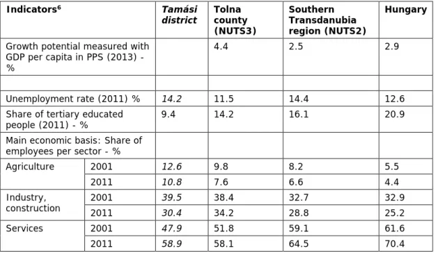
During the last decade of State Socialism, one state farm worked on the former manorial lands and two co-operative farms cultivated the collectivised peasant properties until 1992; one state owned company engaging in forestry and hunting is still operating. The former state farm and the co-operative farms of the town Tamási have been privatised; foreign (mainly German) and Hungarian land owners cultivate large scale farms ranging by size typically form several hundred to several thousand hectares (Figure 2.1).
Figure 2.1: An empty beef breading ranch formerly belonging to the State farm of the town, Tamási- Fornád, July 2017
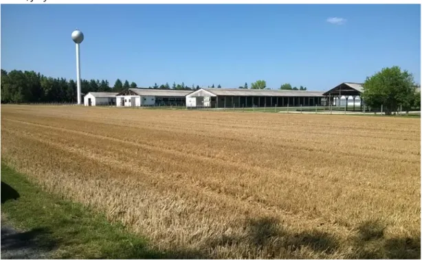
The biggest “genuine” factory of the district operated in Simontornya; it was a well-known leather factory established in 1855 and bankrupted in 1992 as a combined effect of global crisis of the leather industry and “local” impact of the transition. After it’s winding up in 1997, the factory shifted under the control of State Privatisation Agency and was to be sold out. The privatisation process, however, practically failed, only one little company with nine employees continued leather treatment at a small workshop, the rest of the assets was sold out piece by piece, then the site shifted to the property of the town in 2008 (Figure 2.2). The failure was caused by the enormous environmental damage and poisoned soil within the 35 hectare- territory of the factory. The rehabilitation of the environment of 34 million Euros value was completed as late as 2012. Social consequences have been also enormous: from among the more than one thousand wage labourers, hundreds remained jobless: even in 2013, the rate of very long-term job seekers (seeking job for longer than one year) was amongst the highest in the district (33 %). Failed privatisation impacted negatively the entire LAU 1 unit indirectly, through keeping the economy of the town weak for two decades that otherwise could have operated as a small “positive pole” at the northern part of the study area.
Figure 2.2: The “ghost factory” of Simontornya, June, 2017
The collapse of State Socialism swept away industrial subsidiaries and induced an exodus of industrial labour in rural areas that was interpreted by a leading academic as an “export of crisis from centres to peripheries”3, that is: commuters were sacked first and subsidiaries were closed first. A similar exodus of agricultural and industrial laboura from state and collective farms was taking place due to privatisation and that of the transition-related crisis.
Moreover, a new wave of export of crisis from centres to peripheries occurred during the global financial crisis 1.5 decades later. These processes impacted particularly strongly IP areas in general (they were linked to the centres to some extent, therefore they were effected). Being a typical IP territory, all of these processes hit strongly in the Tamási district.
Public administration and changing patterns of governance also impacted chances of development especially during the era of State Socialism. Due to the local realisation of centralisation policies of the 1960s and 1970s, the originally small size of the Tamási district covering the town’s near surroundings, redoubled when it was merged together with that of the Gyönk district in 1961 and then, in 1978, four additional villages were connected to the already enlarged unit. Meanwhile, municipalities were reorganised in 1971 and district subdivisions were organised with provisioning centres. 14 villages lost self-governing authority and had been governed by “common councils” of larger villages or towns. The number of villages without own municipal governance increased from 14 to 18 in the next decade, when another reorganisation of public administration took place (in 1984).
Interviewed stakeholders agreed that the town of Tamási was always too weak to cover the
a Employing skilled and semi-skilled labour in branches of industrial profile of collective farms aiming to achieve more turnover and providing more jobs was common in the 1980s.
entire area of the district with service provisioning and the two smaller towns, Simontornya and Gyönk have also been too little to compensate for the weakness of the centre effectively.
Due to the three main rounds of reorganisation in public administration, small villages lost their public institutions and – since collective farms were also centralised, they lost most of their economic potentials as well. Thus, they had become isolated from resources of development during the era of State Socialism9. Damaging impacts soon appeared regarding human resources, too, feeding into the so called rural exodus: the population of small villages halved during the 1960s and 1970s, young and abled people left the stigmatised villages and moved to rural and urban centres leaving the elderly behind. Since property prices fell dramatically, many houses in these emptying villages were bought up by the Roma population directly or indirectly, through local councils (Figure 2.3).
Figure 2.3: Demise in villages; an abandoned family house covered by weed in Pincehely, July, 2017
It was part of the forced assimilation policy of the time, that Roma colonies were dismantled and then Roma families were helped with state loans to settle in emptying villages. In extended rural areas, mainly in South Transdanubia and Northern Hungary, this was the very start of what later developed to ghettoisation through a selective migration and stemming population change.
In the Tamási district three small villages can be found where ethnic segregation coupled with low social status is present in advanced degree: Értény, Pári and Fürged where the proportion of self-declared Roma population was higher than 20%
according to the last population censusb. Otherwise, the average figure of the
b 20% ratio of the Roma is usually considered by expert of this topic as signal of irreversible ethnic segregation.
representation of the Roma at district level was 6.1% in 2011, significantly higher than in the broader region and the country (see Table 1.1 above and Annex 2), reflecting a geographically sporadic location of Roma neighbourhoods. One of the largest neighbourhoods dominated by Roma households is located in the town of Tamási, rather close to the town centre.
Paradoxically, rural exodus and a kind of rural renaissance took place simultaneously between the beginning of the 1970s and end of 1980s: most of the population of larger villages and rural towns profited from what they were provided through collective farms: they managed to build – through combining auxiliary farming with wage labour in collective farms or industrial work – a relatively prosperous household economy. The same opportunity was not available for small villages (below 500 inhabitants), especially if they were not only small but also dead-end villages.c Rural renaissance took place in rural centres that profited as target areas from rural exodus, the one and the same process that ruined small villages.
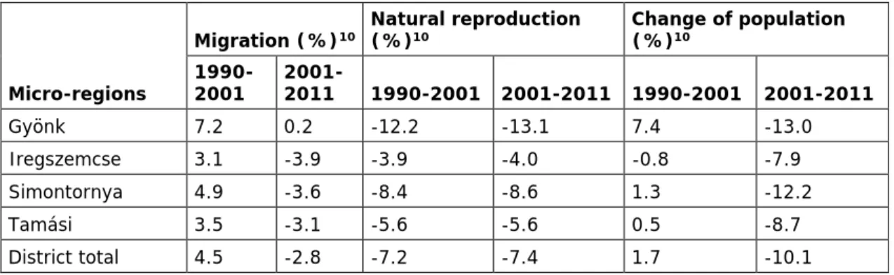
Migration and natural reproduction processes of the two decades after the shift of the political regime is indicated in the below table by micro-regions of the Tamási district (Table 2.1).
Table 2.1: Migration and population trends in the micro-regions of the Tamási district (1990-2011)
Micro-regions
Migration (%)10 Natural reproduction
(%)10 Change of population
(%)10 1990-
2001 2001-
2011 1990-2001 2001-2011 1990-2001 2001-2011
Gyönk 7.2 0.2 -12.2 -13.1 7.4 -13.0
Iregszemcse 3.1 -3.9 -3.9 -4.0 -0.8 -7.9
Simontornya 4.9 -3.6 -8.4 -8.6 1.3 -12.2
Tamási 3.5 -3.1 -5.6 -5.6 0.5 -8.7
District total 4.5 -2.8 -7.2 -7.4 1.7 -10.1
The table clearly shows the change of direction of migration between 2001 and 2011 and also ageing culminating in negative figures of natural reproduction. From demographic point of view, the Gyönk micro-region looks most vulnerable from among the four micro-regions of the district where small-scale villages are dominant (seven out of ten settlement) and where the central town is extremely small as well: its population fell below the magic two thousand recently. (Actually, Gyönk is the smallest town in Hungary with 1911 inhabitants in 2013.) There is another specificity of the Tamási district that is relevant from the point of view of peripherality, rurality and social vulnerability. It is the presence of “external dwelling settlements (“puszta” in Hungarian).
Prior to the WW-II, large manorial estates and peasant farms were operating in agricultural production side by side and shared rural space in a peculiar manner. So called manors,
c There are six dead-end villages in the Tamási district.
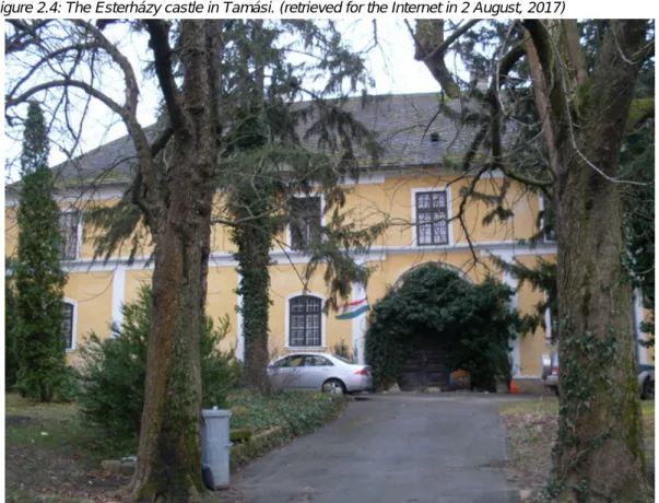
geographically and socially equally distinct settlements were separated from the inner (dwelling) areas of villages and towns. They operated across the “fields” as centres of agricultural production of the large estates and provided dwelling places for managers as well as for manorial labourers. Castles were built in larger manors; they were usually used by their owners, members of the aristocracy, as first or second homes or hunting resorts as that of the Esterházy hunting castle in Tamási (Figure 2.4). Manors combined feudalist legacies in social relations whilst they operated as modern capitalist enterprises with rigid boundaries and rules that were set to make sure the smooth and profitable running of the enterprise and the complete social and spatial separation of the very top and the very bottom of the people there, the aristocrat family, on the one hand, and manorial workers, members of the most vulnerable layer of agrarian proletariat, on the other.
Figure 2.4: The Esterházy castle in Tamási. (retrieved for the Internet in 2 August, 2017)
Ironically, this kind of division of society and space survived the era of State Socialism as centres of state farms. There had been a relatively long transition during late 1940s, early 1950s, when in a number of manors, both the managers (“intézők”) and workers continued to work in the state farms. Former manorial workers represented the most stable part of the population of these “external dwelling settlements” for two reasons: cultural distinction between peasants and manorial workers was extremely strong that allowed mixed marriages rarely. The other reason was rather simple, they were just too poor therefore very much dependent on the services, including cheap or free housing there. A number of former manors still operate as seats of large agricultural enterprises and dwelling places. Most of those who
not only work but also live in these settlements are second or third generation descendants of manorial workers of the interwar period11.
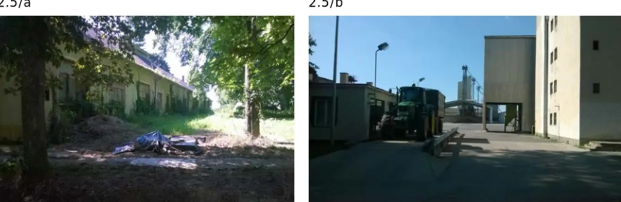
The significance of former manors (“external dwelling settlements”) from the point of view of peripherality is, that they do represent – even more than small-scale villages – spaces where social and geographical disadvantages of extreme degree overlap; most housing facilities are dilapidated since state farms were privatised and at best water and electricity are available from among infrastructural amenities. Accessibility is a huge problem for people who live there (5,7% of the population of the Tamási district in 2011), since the quality of roads is bad, public transport is rare and only few of the families can afford purchasing and running a passenger car. (See the pictures below, Figure 2.5.)
Figure 2.5: External dwelling settlements as places of demise and progress illustrated by abandoned housing facilities (5/a) and a modern farm enterprise (of German owners, 5/b). Tamási-Fornád, July, 2017
2.5/a 2.5/b
Attitudes of descendants of former manorial workers who were in all their life as wage labourers themselves were mentioned by stakeholders as “dependent”, characterised by passivity, inability to initiate, inferiority, social anomies and helplessness. Similar attitudes were attributed to wage labourers, more than one thousand in numbers, of the Simontornya Leather Factory who had become really helpless when the factory was winded up in 1997. “In Simontornya everybody was attached to the factory, generations grew up and worked thered. Their mentality did not change overnight and they were too many” – told the major of the town when she was explaining the reasons of massive and long-term unemployment in the town after the closure of the factory.
These attitudes, of course, do not characterise the entire district just they are attributed to certain social groups being unevenly spread across the area. Nevertheless, a higher representation of “dependency” in administrative, economic and social structures might accumulate and become deterministic to some extent.
d During the 1970s, 1500 wage labourers worked in the factory.
If one tries to depict the nature of peripherality of the Tamási district according to the three models suggested in the interim report, the district seems to fit the most to the third IP model maybe because of the complexity of this model.
Reasons for choosing the third as a most suitable model are as follows:
• exclusion of the area from the agglomeration benefits for economic activity is clearly present and is in a cause-consequence relationship with peripherality, compared to which,
• relatively weak accessibility of SGI can be regarded as a consequence of being spatially distanced and therefore disadvantaged,
• finally, as it was mentioned above, path-dependent mentalities as limitations are also present in certain contexts as one layer of “dependency” available in overlapping human relations as legacies of the socialist or even pre-socialist past.
However, mentalities and weak communication and connecting (lobbying) skills do not feature in all places and all contexts in the same way and degree across the district. In the centre of the district, Tamási, there is a young and dynamic pair of leaders (the mayor and his deputy) who are in an extremely good relationship with leaders in the county seat and even further up.
These relationships are politically based (and biased) but local leaders add efforts to exploit their political connectedness in a way that allows for attracting resources. They do not consider the town disadvantaged and they tend to blame leaders of certain settlements with not working enough for a faster development. Of course, being leaders of the centre, they are in the most favourable position in the district strengthened by political connectedness; too, therefore their judgement does not seem to be fully correct. Nevertheless, differences in mentalities as well as in opportunities are easily identifiable from stakeholder interviews, too.
2.2 The case study against the region, country and Europe
Going deeper into the analysis of data and a broader set of information, causes and characteristics of peripherality of the study area unfolds convincingly.
To start the comparative analysis with employment capacities of main economic sectors, the sharpest decline was produced by industry and construction in the Tamási district amongst investigated territorial units (According to Table 1.2, 9.1 percentage point drop between 2001 and 2011 as compared to 4.2 percentage point at NUTS 3 level, 3.9 percentage point at NUTS 2 level, and 7.7 percentage point at national level) probably because of the overall collapse of subsidiaries ruined the local industrial sector more than it did in some other districts in the county or the region. Parallel with weakening importance of primary and secondary industries in providing employment, services gained momentum thus filled up the small gap between relative absorption capacities of the district and the above territorial levels by 2011 (58.1% at LAU 1 level, 58.1% at NUTS 3, 64.5% at NUTS 2 and 70,4% at national level.) The process was in line with figures of growth being higher in Tolna county than in Southern Transdanubia and the country at large, indicating that Tolna county was in a better shape in 2011 than Baranya or Somogy due mainly to the Paks Nuclear Plant. This is also reflected in unemployment rate of the county, which was still high in 2011 (11.5%) but smaller
than the regional or the national average (14.4% and 12.6%). Rate of job seekers was significantly higher in the Tamási district that time, than the county average (14.2%) but less than the regional average indicating that districts in much worst position prevailed in the other two counties of Southern Transdanubia.
Looking at agricultural employment, one’s impression about the dominance of the sector gets much stronger on the spot given that large scale agriculture prevails and occupies extended parcels, actually the majority of lands, whilst their labour absorption capacity is extremely low (Figure 2.6). This has been the object of complaints in a number of stake-holder interviews.
Figure 2.6: Landscape with large-scale agriculture; Tamási border area, July, 2017
As far as demographic processes are concerned, interestingly enough, two decades after rural exodus, transition-related crisis pushed back a significant number of “returnees” to rural areas, but this tendency turned soon opposite and patterns of outmigration gained new strength during the years of the millennium and after (See Table 2.1 above).
Since the very start of territorial policies and delineation of territories of cumulating disadvantages, the Tamási district has always been among the targeted units (LAU 1 areas) because comparatively (and relatively) it has remained lagging ever since12. If we try to identify main reasons for inability of policy interventions to lift the area from its disadvantageous position, the main feature of the area should be repeatedly emphasized, namely that distances of the Tamási district from core areas was and remained too large and haven’t got overcome by large-scale infrastructural investments (railways, motorways). Being territorially extended but weighting little in terms of population size (applying for villages and rural towns equally), the Tamási district (and inner peripheries in general) has never been
important enough in the eye of policy makers to address their structural problems with effective policies. The scale and kind of interventions should have been much larger than the ones having ever reached them.
A sound and continuous growth of regional centres (county seats), development of road and rail networks – main and side lines, too – could have possibly remedy the situation but neither of these have come about. Moreover, the “capital” of the NUTS 2 region, Pécs is one of the most crises-ridden cities in Hungary. The first crisis was caused by the transformation from state socialism to capitalism in early 1990s and then, the second one was generated by the global financial crisis and hit 10-15 years later. Major industries collapsed during these years (mining and food industries in the first, assembling in the second period) thus structural weaknesses of the city have been conserved up until recently. Since Pécs is the largest centre of Southern Transdanubia, sharp demographic decline in the region and in its three counties (NUTS 3) – two times of the average country figure – was inevitable.
Relative decline of Southern Transdanubia as compared to the NUTS 2 regions of Europe is reflected in its dropping back from the 19th (out of 279) to the 12nd (out of 277) weakest position according to Eurostat’s ranking of NUTS 2 regions by GDP/capita figures. Years of comparison, 2007 and 2015, cover the duration of the previous EU programming period (if we consider N+2 years) highlighting the fact that EU funded interventions could at best diminish economic decline of the region triggered by path-dependent low development potentials induced by a still lasting structural crisis of the early 1990s.
Considering development potentials, one has to point to the fact that Tolna county is one of the smallest NUTS 3 units of Hungary and Szekszárd, its capital is the smallest county seat of the country with around 33 thousand inhabitants. Pécs, the NUTS 2 regional centre has been weakened by both crises, Szekszárd was never strong enough neither in terms of economic potentials nor regarding its administrative and servicing functions; just to mention one important indicator, higher education: it is represented by a “highschool faculty” (főiskola) of the University of Pécs. The weak representation of higher education is impacting negatively the quality of human resources both in the city and in its hinterland including the case study area. (“Young people who leave the county for studying in universities either in Pécs or in Budapest, rarely come back after finishing their studies” – complained one of the stakeholders in an interview.) The transition-related crisis, however, hit Szekszárd also very hard: food industry disappeared – some of the branches almost fully (like meat-processing), others were shrinking fundamentally (like milk-processing) or restructuring lasted for a long duration of time (like in case of wine industry), therefore the loss of jobs in the early 1990s has not been compensated. Therefore, labour absorption capacity in the county seat stagnated at a relatively low level at least until 2016–2017 when investors have reappeared in the region.
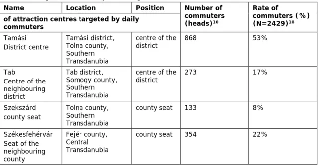
If we consider the movement of labourers of the Tamási district, according to the 2011 Census data, the number of people employed locally (in the village or town where labourers lived) was 7,765 (76% of the registered labourers). The rest, 2,429 people were commuting,
out of which 1,628 commuters (24%) travelled for work each day to four towns, the remaining commuters, 811 people in numbers, targeted other localities. The administrative and geographical positions, roles and labour absorption capacities of the four towns are indicated in the below table (Table 2.2).
Table 2.2: Target locations of daily commuting from the Tamási district, 2011
Name Location Position Number of
commuters (heads)10
Rate of
commuters (%) (N=2429)10 of attraction centres targeted by daily
commuters Tamási District centre
Tamási district, Tolna county, Southern Transdanubia
centre of the
district 868 53%
Tab
Centre of the neighbouring district
Tab district, Somogy county, Southern Transdanubia
centre of the
district 273 17%
Szekszárd county seat
Tolna county, Southern Transdanubia
county seat 133 8%
Székesfehérvár Seat of the neighbouring county
Fejér county, Central Transdanubia
county seat 354 22%
The table clearly shows the extremely weak labour attraction ability of the seat of Tolna county at least from the point of view of labourers commuting from the Tamási district. The neighbouring county seat, Székesfehérvár, which has been a strong industrial and service centre since many decades, attracts almost three times more commuters, than Szekszárd.
Data also inform us about the strength of the town of Tamási in terms of providing job opportunities for working age population of the district. The total number of jobs available in the town was almost the same in 2001 and 2011: 3,467 in the former, 3,452 in the latter year.
However, the rate of those who lived and worked in the town was 88% in 2001 and 75% in 2011 meaning that cross commuting across the district area and beyond increased considerably, whilst job-providing capacity of the town stagnated until 2011.
If one considers data of the below table, it seems obvious, that labour market trends have changed significantly in the 5-6 years passing since 2011 (Table 2.3).
Table 2.3: Unemployment rates in the Tamási district and above territorial levels 2011, 2017
Microregions
No. of villages / towns
No. of 15-64 population 201713
Number of unemployed 201114
Number of unemployed 201713 Rate
201114 Rate 201713
Gyönk 10 4,588 369 221 8.0% 4.8%
Iregszemcse 7 4,996 468 350 9.4% 7.0%
Simontornya 6 6,037 539 288 8.9% 4.8%
Tamási 9 11,140 788 519 7.1% 4.7%
District total 32 26,761 2,164 1,378 8.1% 5.1%
Tolna 4.5%
Hungary 4.2%
2016 average for Tolna 4.7%
2016 average for the Region 6.2%
2016 average for the Hungary 4.4%
Though the above sets of information gained from publicly available data of the National Employment Service are not entirely precise, they do reflect main labour market tendencies that solidly suggest the end of the global financial crisis expressed – among others – in improving access to employment.e
In the Tamási district, unemployment rate dropped to 5.1% recently and not only here, but at below and upper territorial levels, too. What stakeholders mentioned in interviews as drivers of dropping unemployment figures was labour shortages that had become acute in the more developed and industrialised areas home and abroad, therefore interest has emerged towards stocks of labour supposedly available in the “hinterlands”, predominantly in IPs, like the Tamási district. Interest was further increased by the fact that investors were eligible for EU funds and they profited from these funds significantly. For example, the most important and largest foreign company of Tamási, the Philips Lightening Kft. gained substantial support from ERDF funds and it was not the only one. When an assembling company moved from the neighbouring county to Tamási because of labour shortages, the turn of trends had become clear for local leaders. Since then, they forged and formulated their most important development goal like this: “We should bring back our men who are carried day by day as commuters by vehicles of their employers to the industrial zone of Székesfehérvár and let them work almost for the same wage at home.” They estimate that about 1000 commuters could be brought back if the interest of investors remains as intensive as it is nowadays. This goal has shaped another major target of the town’s leaders, namely, adaptation of teaching vocational teaching to the demand of local enterprises and vice versa: “Let’s encourage – they say -- local enterprises to start bursary programs if they want to employ well-trained and loyal labourers”. Other stakeholders have been lobbying recently for a new technical faculty at
e It has to be noted that public workers in Hungary are registered as ordinary employees, therefore data include non-regular labour employed in public employment schemes.
the high-school of Szekszárd that would secure high quality middle and upper leaders, also entrepreneurs in the region in assembling and metal industries. In short, there are people who see the momentum and they are willing to act.
2.3 Internal structure and disparities inside case study region
The sub-divisions of the study area, that of the four micro-regions are named after the central settlements, the three towns (Tamási, Gyönk, Simontornya) and a village of 2,732 inhabitants (2013), Iregszemcse along the main road no. 65 in the north-west part of the districts. Micro- regional centres serve as commercial centres and are supposed to provide basic public services (state administration, education, health care) for the surrounding villages (Figure 2.7).
Figure 2.7: Illustrating functions of micro-regional centres, June-July, 2017
2.7/a Simontornya Coo 2.7/b Iregszemcse village hall
2.7/c Tamási commercial centre 2.7/d Tamási administrative centre
As the below land cover typology suggests, the Tamási district is divided along morphological patterns, too: whilst the territory laying north to the main road No. 61 is flat covered mainly with fields (large-scale arable farming), the are laying south to the main road is hilly, covered by forest more commonly (Map 2.1). It is more fragmented (by the hills), this is the reason why the dominant settlement pattern here is that of small-scale villages around a small town.
Map 2.1: Corine land cover typology of the Case Study area, 2012
Morphological features of the study area determined settlement patterns which – being impacted by state interventions mainly during the era of State Socialism – induced major changes in administrative, economic and social structures. Collectivization, then centralisation for example speeded up exodus from the small villages halving their population during the 1960s and 1970s. These processes made small villages much more vulnerable towards
further racialisation rounds up until recently. This explains the increased vulnerability of the Gyönk micro-region, where the settlement structure is extremely fragmented (seven small village out of nine), density of the population is the lowest as compared to the other three micro-regions (24,5 per km2), ageing is in a most advantaged stage (28,8% old age dependency ratio) and the micro-region suffered from the highest degree of the loss of population between 1999-2013 (16,6%). (For more details see Table IV in Annex 5) At the same time, it is the Iregszemcse micro-region, where people are the least wealthy and another sort of social vulnerability prevails rooting in high occurrence of former manors, on the one hand and ethnic segregation, on the other hand. (Újireg for example is a village of manorial past, whilst in Értény, 26% of the population declared Roma identity in the 2011 Census.)
Unemployment rate was the highest in the Iregszemcse micro-region in 2011 (17,4% against the district average: 12,6%) and remained the highest (7%) by January, 2017. (See Table 2.3 above) This is the sub-unit of the Tamási district, where the rate of tax payers in the % of the population as well as average income per tax payers were the lowest in 1992. Later on, in 2001 and 2011 population of the Gyönk micro-region earned relatively the least as the below table indicates (Table 2.4). Low income figures in the Gyönk micro-region might be explained by high representation of elderly pensioners, on the one hand, and high rate of very long-term job seekers: five out of six villages at the bottom of the list ranked by this indicator belong to the Gyönk micro-region. (In one of the villages, Szárazd for example, half of the job seekers was not able to find a job for more than a year.)
Table 2.4: Rate of tax payers and per capita monthly income in the micro-regions of the Tamási district Territorial units
Rate of tax payers (in
the % of population)6 Per capita monthly income before taxation / tax payer (HUF)6 1992 2001 2013 1992 2001 2013
Gyönk 28% 37% 41% 14,436 52,548 103,720
Iregszemcse 27% 34% 39% 13,512 53,584 104,471
Simontornya 33% 38% 40% 14,802 55,888 122,605
Tamási 36% 41% 43% 16,408 62,574 124,679
Tamási District 32% 38% 41% 15,261 57,881 116,962
Tolna county average 38% 44% 43% 19,223 71,799 154,131
Regional average 40% 42% 43% 18,800 69,977 140,131
Country average 42% 43% 44% 20,809 81,827 160,653
Tamási District figure in the
% of the county average 86% 88% 95% 79% 81% 76%
Tamási District figure in the
% of the Regional average 81% 91% 97% 81% 83% 83%
Tamási District figure in the
% of the country average 77% 90% 94% 73% 71% 73%
It is worth noting that the district has been seemingly catching up in terms of integrating working age population into the labour market and thus among the group of tax payers. At the same time, income level has remained constantly low in the last 25 years.
Table 2.5: Indicators of vulnerability in the micro-regions of the Tamási district Microregion
Indicators6 Gyönk Iregszemcse Simontornya Tamási Tamási district Rate of job seekers in the
percentage of population 18-64 (2013)
6.7 11.9 9.6 7.1 8.5
Rate of very long term job seekers (longer than 1 year) in the % of job seekers (2013)
21.8 24.1 28.0 25.1 25.1
Dwelling units without
any conveniences (2011) 17.2 19.6 14.2 9.7 13.9
Passenger cars per 100
dwelling units (2013) 57.4 54.9 56.2 71.0 62.2
The above table highlights again, the high social vulnerability of the Iregszemcse micro- region, where the rate of job seekers is the highest and the rate of those who could not find employment for more than a year is also rather high (Table 2.5). This is also the micro-region, where the quality of housing facilities is the lowest and people can afford to compensate for the poor mobility opportunities provided by public transport the least of all: the number of passenger cars falling to one dwelling unit is as few as 55.
The Simontornya micro-region stands closer to that of the Tamási micro-region because data of the town dominate over that of small villages (Map 2.2; Map 2.3). At the same time, however, unemployment rate was still rather high in 2013 and the rate of very long-term job seekers within the group of job seekers was the highest in the district reflecting that the industrial site (buildings of the former factory) was not yet utilised.
The Tamási micro-region including the district centre of around nine thousand inhabitants is by far in the best situation as compared to the other three micro-regions. So-called structural unemployment does seemingly exist in this micro-region indicated by the relatively high rate if very long-term job seekers, too, due to the numerous former manors and also, to the segregated neighbourhoods within as well as outside of the town’s boundaries (Pári).
Otherwise the gap is wide between the Tamási district and the other three, especially regarding indicators of wealth, like the relative number of passenger cars and the low rate of dwelling units without any conveniences.
Map 2.2: Rate of job seekers in the percentage of population 18-64, 2013
Map 2.3: Rate of very long-term job seekers (longer than 1 year) in the % of job seekers, 2013
2.4 The case study as a subject of local, regional and state coping strategies
2.4.1 Institutional structure and planning 2007-2013
In the former programming period, regional development concepts and programs were generated in three territorial levels, in the central government, in NUTS 2 so-called “statistical and development regions” and in LAU 1 level districts. Neither of the latter levels was led by elected self-governing bodies; at regional level, a so-called Regional Development Council was in charge of decision taking whilst at LAU 1 level, elected leaders of the member
municipalities, that is mayors were members of the decision taking body headed by one mayor elected by fellow mayors. Although the programming process was meant to proceed
“from below”, influence of central and even EU level was dominant mostly in terms of determining main priority axes and allocation of budgetary tools at NUTS 2 level. This explains the striking similarities in ROPs. Leading programming documents, seven OP-s were compiled at NUTS 2 level, which were approved by the national and European authorities. At below levels, planning was taken much less seriously, however, in order to gain eligibility for specific funding schemes – like for example the Complex Program – planning along centrally designed templates was mandatory.
The most important area-based development programmes of the previous planning period - that actually held dedicated resources for implementation - were the South Transdanubian Regional Development Operational Programme (SDROP) and that of the LEADER Rural Development Strategy (Annex 3; Annex 4). In the former document, peripherality is highlighted in the situation analysis as well as in SWOT analysis; moreover, in line with the PROFECY project, Tamási district and the surrounding LAU 1 units along the county borders were classified as inner peripheries. The rest of the Programming documents do not put much emphasis on peripherality and measures aimed at tackling specific problems arising from it.
They address territorial disparities (cohesion) and/or rurality.
As it was introduced in the first chapter of this case study, five neighbouring LAU 1 units create an adjacent border area of three counties in the Transdanubian Region, all the three are in a similar (inner) peripheral situation. It is relevant from the point of view of 2007-2013 programming period that from among these LAU 1 units one, the study area, Tamási was grouped by a Government Decree into the most disadvantageous 33 districts (called micro- regions at that time)15, whilst another one (Tab district) was listed under the next 14 underdeveloped category and two (Enying and Sárbogárd districtsf) were classified as moderately disadvantageous, meaning that peripheral situation does not translate always to the same degree of lagging. However, methodology and indicators of classification determine the outcome significantly. (According to a geographical analysis from early 1990s for example, Tab district was considered as much disadvantageous as that of the Tamási district.)
Disadvantages were addressed by the SDROP as well as that of peripheral geographical location of IP areas. Mainly that of the 5th priority axis aiming better connectedness to be achieved through an improved road network and an enhanced public transportation aimed at an easier accessibility of urban centres can be considered relevant development tools tackling peripherality. Strengthening economic performance (priority no 1.) and developing accessibility of public services (priority no 3) could be interpreted as measures impacting
f These two districts are located closer to urban centres and belong to another NUTS 3 unit (Fejér county) and NUTS 2 Region (Central Transdanubian Region).