Supplementary materials
Table SM1. Characteristics of the cartographic sources used in the study
No Name Source The scale and format
1. First Military Survey maps of the Habsburg Empire [Josephinische Landesaufnahme] (1763–1787)
The Historical Map Portal www.mapire.eu
(accessed 2018.04.17)
Scale 1:28 800, georeferenced 2. Map of Brześć District, around
1796 Central Archives of Historical
Records,
Cartographic collection 68-3.
Approximate scale:
1:200 000, scanned (TIF) 3. Second Military Survey maps of
the Habsburg Empire
[Franziszeische Landesaufnahme]
(1806–1869)
The Historical Map Portal www.mapire.eu
(accessed 2018.04.17)
Scale 1:28 800, georeferenced
4. Map of Białowieża Forest [Plan des Waldes von Bialowesha]
Eichwald 1830 Approximate scale:
1:150 000, scanned (TIF) 5. Map of Military Geographical
Institute [Wojskowy Instytut Geograficzny] 1919-1939, the sheets:
P37 S37 Narew P37 S38 Hajnówka P38 S37 Dobrowola P38 S38 Białowieża P50 S35 Dobromil P53 S38 Dolina
Archiwum Map Wojskowego Instytutu Geograficznego 1919-1939, www.mapywig.org (accessed 2018.04.17)
Scale: 1:100 000, scanned (TIF)
6. Military Survey of Hungary (1941) The Historical Map Portal www.mapire.eu
(accessed 2018.04.17)
Scale1:100 000, georeferenced 7. Ortho-photo images (2014–2017) Google Earth Pro (Version
7.3.1.4507): Google Inc. (2018). georeferenced
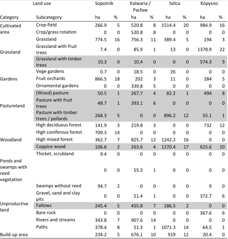
Table SM2. Land use structure of four communities according to the 1850’s “Ausweis über die Benutzung des Bodens” (the acreage has been re-calculated from the original land register forms deposited in the National Archive in Przemyśl). In grey: such land use categories, which might have fostered oak woods development. Sopotnik - location of PL2,3; Kalwaria / Pacław - PL4,5,9; Sólca - PL8; Kopysno - PL6; grey rows refer to historical land use categories apparently beneficial for oak regeneration, almost absent in the contemporary landscape
Land use Sopotnik Kalwaria /
Pac
ł
aw Sólca KopysnoCategory Subcategory ha % ha % ha % ha %
Cultivated area
Crop-field 266.9 5 520.8 8 1514.4 20 984.9 16
Crop/grass rotation 0 0 520.8 8 0 0 0 0
Grassland
Grassland 774.5 16 756.3 11 389.4 5 194 3
Grassland with fruit
trees 7.4 0 85.9 1 13 0 1378.9 22
Grassland with timber
trees 10.3 0 10.4 0 0 0 574.3 9
Gardens
Vege gardens 0.7 0 18.5 0 26 0 0 0
Fruit orchards 866.5 18 202 3 11 0 284 5
Ornamental gardens 0 0 339.8 5 0 0 0 0
Pastureland
(Wood) pasture 50.5 1 267.7 4 82.2 1 494 8
Pasture with fruit
trees 48.7 1 393.1 6 0 0 0 0
Pasture with timber
trees / pollards 268.3 5 0 0 896.2 12 55.1 1
Woodland
High deciduous forest 141.9 3 219.8 3 0 0 732 12
High coniferous forest 709.3 14 0 0 0 0 0 0
High mixed forest 362.7 7 825.7 12 1242.2 16 0 0
Coppice wood 106.6 2 263.6 4 1270.4 17 615.6 10
Thicket, scrubland 9.4 0 0 0 0 0 0 0
Ponds and swamps with reedvegetation
0 0 55.3 1 0 0 0 0
Unproductive land
Swamps without reed 94.7 2 0 0 0 0 9 0
Gravel, sand and clay
pits 0 0 51.4 1 0 0 372.7 6
Fallows 245.4 5 455.8 7 186.5 2 0 0
Bare rock 0 0 0 0 0 0 367.6 6
Rivers and streams 343.8 7 907.6 14 0 0 0 0
Paths 378.4 8 51.3 1 1071.3 14 64.5 1
Build-up area 234.2 5 676.1 10 919 12 20.4 0