MIDDLE AND LATE PLEISTOCENE LOESS-PALAEOSOL ARCHIVES IN EAST CROATIA: MULTI-PROXY
PALAEOECOLOGICAL STUDIES ON ZMAJEVAC AND ŠARENGRAD II SEQUENCES
Dávid Molnár
1, 2*, László Makó
1, 2, Péter Cseh
1, 2, Pál Sümegi
1, 2, István Fekete
3, Lidija Galović
41 Department of Geology and Paleontology, University of Szeged, H-6722 Szeged, Egyetem u. 2-6, Hungary;
e-mail: molnard.geo@gmail.com
2 University of Szeged, Interdisciplinary Excellence Centre, Institute of Geography and Earth Sciences, Long Environmental Changes research team, H-6722 Szeged, Egyetem u. 2-6, Hungary;
3 Department of Physical Geography and Geoinformatics, University of Szeged, H-6722 Szeged, Egyetem u. 2-6, Hungary;
4 Croatian Geological Survey, Sachsova 2, 10001 Zagreb, Croatia.
* corresponding author Abstract:
Multi-proxy palaeoenvironmental analyses on the two loess-palaeosol sequences of Šarengrad II and Zmajevac (Croatia) provided the opportunity to obtain various data on climatic and environmental events that occurred in the southern part of the Carpathian Basin during the past 350,000 years. Palaeoecological horizons were reconstructed using sedimentological data (organic matter and carbonate content, grain-size distribution and magnetic susceptibility) and the dominance-based malacological results (MZs) supported by habitat and richness charts, moreover multi-variate statistics (cluster analysis). The correlation of the reconstructed palaeoecological horizons with global climatic trends (Marine Isotope Stages) determined the main accumulation processes in the examined areas. The palaeoecological analyses revealed specific accumulation conditions at both sequences, fluvial and aeolian environments at Šarengrad and a possible forest refuge at Zmajevac.
Key words: palaeoecology, malacology, sedimentology, Šarengrad, Zmajevac, Croatia Manuscript received 17 March 2020, accepted 1 October 2020
INTRODUCTION
Multi-proxy investigations on loess-palaeosol se- quences provide palaeoecological information about the environmental and climatic conditions during the period of sediment accumulation. Multi-proxy investigations of nu- merous sites in the Carpathian Basin (Sümegi, 1989, 1996, 2005; Sümegi et al., 2013, 2015, 2016, 2018, 2019, 2020;
Újvári et al., 2010, 2014) show evidence for a mosaic-like environmental situation during the Quaternary (Sümegi, 1995, 1996; Sümegi and Krolopp, 1995, 2002; Sümegi and Hertelendi, 1998).
This study presents palaeoecological reconstruction based on sedimentological and reprocessing of previously published malacological data (Hupuczi et al., 2010; Molnár et al., 2010; Molnár, 2015) of two East Croatian loess-
palaeosol sequences (Zmajevac and Šarengrad II), situated on the right bank of the Danube River (Fig. 1). Various investigations of these profiles have been already published (Galović et al., 2009, 2011; Banak et al., 2013; Galović, 2014, 2016; Galović and Peh, 2016), but both sedimento- logical and malacological results were available only from these two sequences. Correlating these sequences with each other to present a continuous chronological-palaeoen- vironmental reconstruction for East Croatian loess during the Middle and Late Pleistocene. By combining previously completed malacological investigations of these sequences (Hupuczi et al., 2010; Molnár et al., 2010; Molnár, 2015), with new sedimentological results and absolute age data (Galović et al., 2009; Wacha et al., 2013), we generate a robust palaeoecological reconstruction and chronostrati- graphic correlation for this region.
GEOGRAPHICAL SETTING AND LITHOLOGY
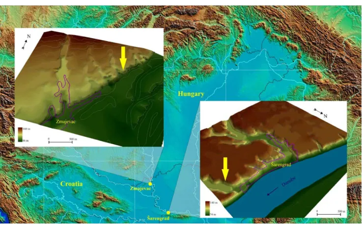
Both sequences are located at the eastern border of Croatia near the Danube River (Fig. 1) and were sampled during the Croatian-Hungarian bilateral agreement in 2008. The ca. 23 m high Šarengrad II sequence is situated in the NE facing wall of a dry valley, a few hundred metres from Šarengrad village. The 25 m high Zmajevac sequence is also located close to the Danube River, but a floodplain of the river is wider in this area (Fig. 1). Neither of these se- quences was sampled completely, because of their heights and unapproachability.
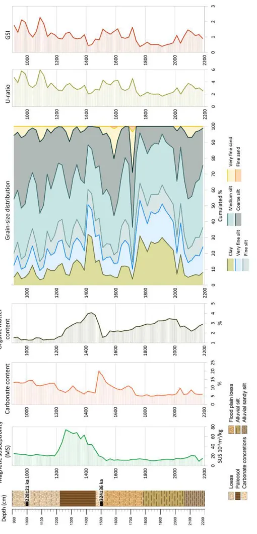
The 23 m high Šarengrad sequence was sampled be- tween 9 and 22 m. The sampled portion was divided into 5 parts (sediment layers) (Fig. 2). From bottom to top, the first layer is an alluvial sandy silt layer at 2200–2062 cm depth. Above this site, a 275 cm thick alluvial clayey silt layer occurs at 2062–1787 cm depth. The next layer up con- tains a 325 cm thick flood-plain (or infusion) loess (Pécsi, 1990) layer at 1787–1462 cm. From the top of this layer, the fading corrected IRSL results showed the age of the horizon to be around 324±36 ka at 1500 cm (Wacha et al., 2013). Between 1462–1222 cm a 240 cm thick palaeosol complex developed containing a carbonate accumulation horizon at 1500–1462 cm. The uppermost sampled part of the sequence from 1222 cm to 900 cm contains a more than 300 cm thick loess layer, with an additional fading cor-
rected IRSL data at 1000 cm, showing the age of 228±21 ka (Wacha et al., 2013). The non-sampled parts of the sequence comprised the lowest 1 m of the section, which consists of alluvial sand (2300–2200 cm), and the uppermost part of the sequence (900–0 cm), which contained loess and palae- osol layers (Wacha et al., 2013).
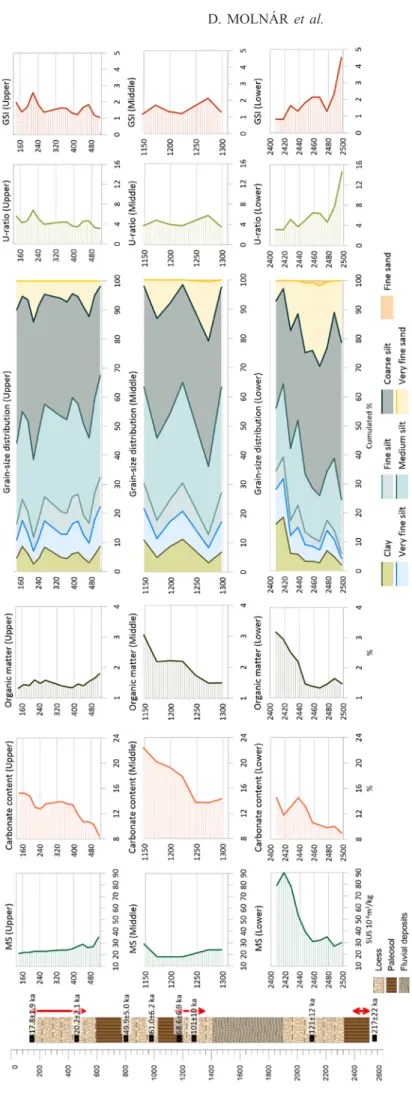
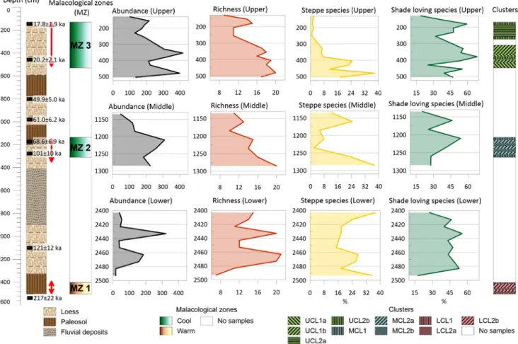
The whole Zmajevac sequence could be separated into 8 layers: 4 loesses, 3 palaeosols and a pedosediment horizon with fluvial interbeddings (Galović et al., 2009). However, the sampling of the Zmajevac sequence was difficult, owing to the unapproachability of several parts of the sequence due to a lack of adequate equipment (e.g. scaffolding). Thus only 3 parts of the 2500 cm high profile were sampled, so the lith- ologic description is necessarily confined to these 3 parts (or sub-sequences), which were named Zmajevac Upper (525–
130 cm), Zmajevac Middle (1310–1150 cm) and Zmajevac Lower (2503–2403 cm) (Fig. 3). The Zmajevac Upper over- laps the uppermost loess layer, the Zmajevac Middle partly overlaps the second palaeosol and the third loess layers, and the Zmajevac Lower is in the lowermost (3rd) palaeosol layer.
Absolute age data (MAAD IRSL) from this section (Galović et al., 2009) ranges between 17.7±1.9 ka to 217±22 ka (Fig. 3).
MATERIAL AND METHODS
The sampling interval was 25 cm for both sequences, except the Zmajevac Lower sequence where the sampling
Fig. 1. Areal DTMs showing the locations of the examined loess-paleosol sequences (yellow arrows show the exact locations of the sequences; contour lines remarks 10 m elevation).
Fig. 2.Lithology and the results of sedimentological analyses of Šarengrad II sequence. Fading corrected IRSL data was obtained from Wacha et al. (2013).
Fig. 3.Lithology and the results of sedimentological analyses of Zmajevac sequence. Red arrows indicate the sampled sub-sequences (ZM Upper, Middle and Lower). MAAD IRSL data was obtained from Galović et al. (2009).
interval was 10 cm (Fig. 3). About 5 kg of bulk sediment was taken from each interval. Most of the sediment was used for malacological examinations (wet-sieving), the re- maining sediment (approx. 50 g) was used for sedimen- tological analyses. Loss on ignition (LOI), magnetic sus- ceptibility (MS), and grain-size distribution analyses were carried out on both sequences.
It is important to notice the differences between the applied IRSL methods at Zmajevac and Šarengrad II.
At Zmajevac, Galović et al. (2009) used MAAD IRSL analyses, which were not corrected for fading, so the age data may be underestimated. At Šarengrad II, Wacha et al. (2013) used fading corrected IRSL and post-IR IRSL 225 methods for chronology and they rather accepted the fading corrected IRSL ages. The difference between the chronological methods generates uncertainty in the chronology.
The malacological sampling, cleaning, and identify- ing were carried out according to the methods by Endre Korolopp and Pál Sümegi (Krolopp, 1983; Sümegi, 1996, 2005). Identification, and the knowledge of each species’
climatic and environmental demands, can help for creating palaeoecological reconstruction datasets with rather simple mathematical calculations (Krolopp, 1983; Sümegi, 1989;
Krolopp and Sümegi, 1992, 1995; Sümegi and Krolopp, 1995), such as the species’ abundance and dominance re- lations per sample (Krolopp, 1983; Ložek, 1964; Antoine et al., 2001; Alexandrowicz and Dmytruk, 2007). By us- ing these datasets, the snail species can be clustered into palaeoecological groups such as climatic, humidity and vegetation cover demands (Rousseau, 1990a; Rousseau and Kukla, 1994; Sümegi and Krolopp, 1995; Sümegi, 1996, 2005; Rousseau and Puisségur, 1999; Moine et al., 2005).
All three factors depend upon each other, besides the changes in other (less important) conditions.
Beyond the dominance and abundance analyses, more sophisticated statistical analyses were also carried out.
These statistical analyses were made by using the malaco- fauna data, based on Podani’s classification and ordination operation which was drawn up for comparison of mollusc faunas (Podani, 1978, 1979). The aim of these analyses to find similarities and distinctness among the malacologi- cal assemblages in each sample (Rousseau, 1990b, 1991;
Rousseau and Puisségur, 1999; Southwood and Henderson, 2000). Cluster analysis was fulfilled by analysis of princi- pal components by using squared Euclidean distance and Ward aggregation method (Dowdeswell, 1982). By the sup- port of these analyses, the determination of samples with the same environmental and deposition conditions was pos- sible, furthermore, the palaeoecological key species could be identified. For the cluster analysis, the Past 3.20 soft- ware-kit (Hammer et al., 2001) was used.
The grain size composition of sedimentological samples was carried out using the laser-diffraction method (Konert and Vandenberghe, 1997). All samples were measured for 42 intervals between 0.0001 and 0.5 mm using an EasySizer 2.0 laser diffraction particle sizer in Szeged (Hungary).
Cumulated percentage ratio was calculated by each grain-
size range according to Wentworth’s scale. U-ratio was cal- culated (16–44 µm/5.5–16 µm) for determining the signifi- cant and the subordinate phases of wind transport, such as the temperature and humidity (Vandenberghe, et al. 1985, 1997; Vandenberghe and Nugteren, 2001; Nugteren et al., 2004; Vandenberghe, 2013). Besides the U-ratio the grain size index (GSI – 20–50 µm/<20 µm) was calculated. This index even considers the clay fraction, thus it is suitable for determining the formation, transportation, and accumula- tion of the loess (Rousseau et al., 2002, 2007).
Environmental magnetic analyses were carried out on bulk samples (Zhou et al., 1990; An et al., 1991; Rousseau and Kukla, 1994; Sun and Liu, 2000; Zhu et al., 2004). Firstly, all samples were crushed in a glass mortar after weighing.
Then all samples were cased in plastic boxes and dried in the air in an oven at 40°C for 24 hours. Afterwards, magnetic susceptibilities were measured at a frequency of 2 kHz us- ing an MS2 Bartington magnetic susceptibility meter with an MS2E high-resolution sensor (Dearing et al., 1996). All samples were measured six times and the average values of magnetic susceptibility were computed and reported.
The determining of the changes in organic matter and carbonate content loss on ignition (LOI) method were used (Dean, 1974; Heiri et al., 2001). During this procedure, dry and powdered bulk samples were ignited at several tem- peratures in a furnace. The weight of the samples was mea- sured after each ignition, allowing the weight loss of the organic matter and carbonate content to be quantified. The ignition of the organic matter occurred at 550°C degrees and the carbonate content occurred at 900°C degrees. The results were presented in percentage distribution.
RESULTS Results of sedimentological analyses Šarengrad II sequence
The results of the sedimentological analyses are dis- cussed according to the lithologic units of the sequence as described above.
2200–2062 cm: At the lowermost, fluvial originated layer, organic matter content (OC) values fluctuated be- low 3% while the carbonate content was around 5%; aside from one accumulation horizon, where the values reached 8% (Fig. 2). The lower OC may reflect changed energy conditions in the fluvial system because the sediments of flowing water systems usually contain less organic matter (Keller and Swanson, 1979). The clay content in the layer was around 5–6%, besides increased coarse silt and very fine sand proportion, with an average of 10% sand frac- tion. These characteristics (especially the sand content) reflect more intensive, but steady flow conditions. The graphs of U-ratio (~3–4) and GSI (~1–1.5) seem similar, reflecting the increased amount of coarse grains, espe- cially the sand deposits. The MS values were around ~20 in this layer.
2062–1787 cm: In this layer, OC gradually increased to maximum values of around 3.5% in the lower part of the layer. The carbonate content of this layer is around 5%, with a small increase in the lowermost part (~10%). This probably indicates energy changes in the fluvial system (Keller and Swanson, 1979). The clay content increased and fluctuated around 25–30%, meanwhile the sand de- creased to zero in this layer. This probably reflects a still or a slow-flowing alluvial accumulation system in this layer.
The U-ratio and the GSI values fell around ~2 and ~0.5, in- dicating the decreased rate of coarse grains. The MS values were below 20 in this layer.
1787–1462 cm: In the flood plain loess layer, the OC values could refer to a gradually fell from ~3% to ~1.5%, then from 1500 cm increased above 3%. The decreasing part could refer to the gradually drying environment, and the increased OC amount in the uppermost part of the layer refer infiltration from the cover palaeosol layer. At the uppermost part of the layer, the carbonate content sug- gests an accumulation horizon (~20%). The clay content fluctuates between ~5% and ~30%. The highest content was at the lowermost part of the layer, then decreased to
~7% in 1600 cm. An increase (~15%) could be noticed from 1500–1462 cm. The gradual clay decrease was interrupted two times (at 1720 and 1580 cm) by increased sand depos- its. The lower one resulted in ~30%, the upper one resulted in ~20% sand content. Considering the mean 3–4% sand content in the layer, these events were exceptional. The U-ratio and GSI graphs show increased values (3–4 and 1–1.5) at the sand deposit horizons and the upper part of the layer, indicating coarsen grain-size distribution. MS values reach 40 in the uppermost part of the layer.
1462–1222 cm: The palaeosol layer has the highest OC values (~4%) of the sequence. The carbonate content of this layer is around 8%, except at 1310 cm, where it is slightly higher (~10%). This might be linked to decalcifica- tion processes in the B horizon (Ding et al., 2001). The clay content gradually increases to 35%, reflecting pedogenetic processes and intensive weathering. The clay content then decreased to 10% mean. At 1250 cm the increased U-ratio and GSI values indicate a less weathered horizon in the pa- laeosol. On the other hand, the MS values are around 80 in the palaeosol layer and do not indicate any less weathered horizons.
1222–900 cm: In the uppermost sampled loess layer the LOI determined organic OC values were around 1.5%, the carbonate content was around 12–15%, which is common in loessy layers in other sequences (Pécsi, 1990). The OC values increased (~2%) while the carbonate content de- creased (to ~8%) in the lower part of the layer, initiating the next palaeosol level.
Typical loess layers with low clay and high middle to coarse silt content (Pécsi, 1990; Pye, 1995; Vandenberghe, 2013) characterise the aeolian environment. The clay con- tent is under 10% in this layer except for the lowermost part where it reaches 10%, with increasing OC content. The layer also contains negligible amounts of very fine sand (average 5%), which may reflect higher wind energy during
accumulation (Pye, 1995). Two more intensive sand depo- sition horizons were noted at ~1100 cm and ~950 cm where the sand content approached 10%. These horizons are well remarked in the U-ratio and GSI graphs as well, with the values of ~6 and ~2–2.2. MS values around 22 were in this horizon, as typical in the barely weathered loess layers.
Zmajevac sequence
2503–2403 cm (ZM Lower): In Zmajevac Lower the or- ganic matter content (OC) gradually increased from 1.5%
to 3%, meanwhile the carbonate content (from 9% to 15%) and MS values (from 30 to 90) followed this trend (Fig. 3).
Since this sub-sequence extent in the lowermost palaeosol layer, these results may suggest a transition of the palaeosol levels. The clay content, similarly to the OC and carbon- ate content, gradually increased, between 2430–2403 cm was around 20%. Opposite with the increased clay content, the coarse grain content (coarse silt and sand) decreased, between 2503–2450 cm its ratio reached 70–75%. In this stage, the U-ratio (between 6–13) and the GSI (between 1.5–4.5) values were exceptionally high.
1310–1150 cm (ZM Middle): In the palaeosol-loess tran- sition Zmajevac Middle sub-sequence the OC values were initially low (~1.5% to ~2.3%) in the loess and higher (~3%) in the palaeosol layer. The carbonate content does not fol- low the same trend. In the palaeosol, it is 25% whilst in the loess, it is only 20%. The interpretation of this anomaly could be a carbonate accumulation horizon in the lower part of the palaeosol layer. The clay content fluctuates between 3% and 10% and two increased sand deposition could notice in 1175 cm and 1275 cm, surprisingly the up- per one in the palaeosol. Around 1175 cm, the MS values were also surprisingly low, below 20. The U-ratio (~4.5 and
~5.7) and the GSI (~1.6 and ~2.1) evenly indicate the coarse grain deposition in these two horizons.
525–130 cm (ZM Upper): The OC and carbonate con- tent of Zmajevac Upper sub-sequence are typical for loessy sediments (1–1.5% and around 15% respectively) (Fig. 3).
These circumstances only break in the lower part of the sub-sequence, where a slight increase can be observed in the OC, and parallel with that, a decrease in the carbonate con- tent. This could be indicated by pedogenetic processes of the nearby palaeosol ZS1. The grain-size distribution has a typical, loess like composition: low clay content (5–7%), and very high medium to coarse silt content, around 70% (Pécsi, 1990; Pye, 1995; Vandenberghe, 2013). The amount of very fine sand is higher than usual in the sub-sequence (10–15%), which could be linked to more intensive wind speed during accumulation (Pye, 1995). Three peaks of intensive coarse grain deposition could reconstruct via the U-ratio and GSI graphs. These peaks were around 470 cm (U-ratio: ~4.7;
GSI: ~1.75), 220 cm (U-ratio: ~6.9; GSI: ~2.6) and 130 cm (U-ratio: ~5.5; GSI: ~2). MS values – similar to the OC and carbonate content – reflect its loess origins, however, in the lowest part of the sub-sequence the MS values slightly in- crease, similarly to the OC and carbonate content.
Results of malacological analyses Šarengrad II sequence
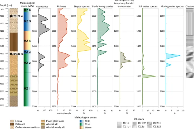
The dominance-based malacological analyses resulted in 6 malacological zones (MZs) of 3450 specimens of 51 terrestrial and freshwater snail and clam taxa from 52 samples (Hupuczi et al., 2010; Molnár, 2015). Now, these malacological zones have supplemented with additional data, such as richness, ratio of open vegetation preferring (steppe), shade-loving, temporary flooding, stagnant and moving water species, and the dominance-based cluster analysis (Fig. 4).
MZ1 (2200–1750 cm): Sporadic occurrence of mollusc shells have marked this zone, all of the found shells be- longed to freshwater species. Regarding this zone overlaps the lowermost two sediment layers which were both fluvial originated, the molluscs support the sedimentological re- sults. The abundance and the richness were negligible in this zone. A higher ratio of still water species could notice around 1800 cm in the alluvial silt layer, which could in- dicate a cut-off ox-bow lake or back-swamp environment (Figs 2 and 4).
MZ2 (1750–1500 cm): The second malacological hori- zon overlaps the floodplain loess layer and characterised by both freshwater and terrestrial species. The high number of richness (usually over 10 but reaches 20 around 1550 cm)
also represents a transition zone of fluvial and terrestrial environments. The ratio of the diverse demanding species was characterised by the noticeable ratio of stagnant wa- ter species up to 1700 cm, then moving water and mostly temporary flooding tolerate species occurred with a higher ratio. Two peaks of moving water species could be noticed in this zone, around 1650 cm and 1550 cm. These two peaks maybe refer to crevasse splay events, when higher amounts of fluvial elements could have in-washed the back-swamps.
MZ3 (1500–1450 cm): In this short-term zone, which lays in the uppermost part of the floodplain loess layer, the freshwater species disappeared and terrestrial species become dominant, while the richness decreased below 10 species per sample. The ratio of shade-loving species broke away (over 40%) besides mesophilous and cold-resistant hygrophilous and sub-hygrophilous (Hupuczi et al., 2010;
Molnár, 2015) species. These fauna changes indicated a permanently non-flooded area with increased tree cover, such as an upland forest.
MZ4 (1450–1200 cm): This malacological zone over- laps the palaeosol layer and could be characterized by the noticeable dominance of warmth-loving and mesophilous species, indicating a warming period (Fig. 4). The recon- structed July palaeotemperatures were over 16°C in this zone (Hupuczi et al., 2010). The ratio of the steppe and the shade-loving species fluctuated in this horizon, over ~50%
ratio of the steppe species was typical, only two higher
Fig. 4. Results of the supplemented malacological data from Šarengrad II. Malacological zones (MZ) were obtained from Hupuczi et al. (2010) and Molnár (2015).
peaks of shade-loving species could be noticed at 1375 cm and 1325 cm. The richness in this zone was relatively low but gradually increased from ~3 to ~15 species per sample.
In the top of the zone, the ratio of shade-loving species in- creased again and reached ~50%.
MZ5 (1200–950 cm): The fifth malacological zone was characterised by the decreased dominance ratio of warmth-loving species, besides the increased dominance ratio of cold-resistant and cold-loving species, indicating colder climatic conditions. The increase of the shade-loving species’ ratio continued and stabilised around 60% between 1200–1100 cm. From 1100 cm the ratio decreased to ~35%.
The ratio of steppe species was subordinate, it fluctuated around 40%. The richness was around 15 in this zone, but it fell (together with the abundance) to 5 species per sample in the top of the zone.
MZ6 (950–900 cm): In the youngest zone the cold-lov- ing and cold-resistant species withdrawn and the mesoph- ilous and warmth-loving species became dominant again.
During this warmer period, the ratio of shade-loving spe- cies decreased around 20%, whilst the ratio of steppe spe- cies reached 70%. The richness remained below 10 species per sample. This malacological zone could be characterised with the lowest mean ratio of shade-loving species in the Šarengrad II sequence.
Cluster analysis (900–1825 cm): The cluster analysis could only be calculated with samples where at least two different species occurred, so continuously it was calcu- lated between 900 cm and 1825 cm (Fig. 4; Suppl. Fig. 1 – supplementary figures available only in the online version).
For determining the affinity of each sample’s malacofauna composition, cluster analyses were executed. The cluster analysis divides the malacofauna into two sides (CL1 and CL2) with the highest affinity distance (280).
CL1 could be divided into two sub-clusters, CL1a and CL1b with affinity distance of 160 (Suppl. Fig. 1). CL1a in- cludes only one sample, between 1425–1450 cm, where the mesophilous, steppe species Pupilla muscorum had its high- est dominance ratio. CL1b could split further into CL1b1 (900–950 cm; 1250–1400 cm) and CL1b2 (950–1250 cm) with 135 affinity distance. CL1b1 could be described with relatively high dominance of warmth-loving species (Pupilla triplicata, Granaria frumentum, Helicopsis stirata) and overlaps the MZ6 and partly the MZ4 (Fig. 4). CL1b1a (1250–1375 cm) and Cl1b1b (900–950 cm and 1375–1400 cm) sub-clusters could be determined with 80 affinity distance (Suppl. Fig. 1). CL1b1a could be described with Pupilla trip- licata, Granaria frumentum, Pupilla muscorum, Vallonia costata hallmarked fauna composition, whilst CL1b1b could describe P. triplicata, V. costata fauna composition. CL1b2 (950–1250 cm) even could split into two sub-clusters with 80 affinity distance: CL1b2a (1000–1050 cm; 1100–1225 cm) and CL1b2b (950–1000 cm; 1050–1100 cm; 1225–1250 cm). CL1b2a could be described with presence of cold-re- sistant and cold-loving species, such as Trochulus hispidus, Orcula dolium, Vallonia tenuilabris and Columella colu- mella. Cl1b2b could be described with an increased domi- nance ratio of the mesophilous Vallonia costata.
CL2 could be divided into two parts with 190 affinity distance, CL2a (1400–1425 cm; 1450–1475 cm) and CL2b (1475–1825 cm) (Suppl. Fig. 1). CL2a could be described with the increased dominance ratio of the warmth-lov- ing Chondrula tridens, and CL2b hallmarks the terres- trial-freshwater transition and the solely freshwater envi- ronment. CL2b could split further CL2b1 (1475–1525 cm;
1550–1600 cm; 1750–1825 cm) and CL2b2 (1525–1550 cm;
1600–1750 cm) with 150 to 45 affinity distances. CL2b1 is rather a collective group calculated by mainly the domi- nance ratio of freshwater species. The 1475–1525 cm hori- zon was hallmarked by the terrestrial Trochulus hispidus and the temporary floods preferring Galba truncatula. The 1550–1600 cm horizon could be described with the pres- ence of the common freshwater species of Valvata cristata and Planorbarius corneus. The 1750–1825 cm horizon was hallmarked by the common freshwater species Valvata pi- scinalis and the still water preferring Viviparus contectus.
CL2b2 could split further to 2 sub-clusters: CL2b2a (1525–
1550 cm; 1600–1650 cm) and CL2b2b (1650–1750 cm) with 35 affinity distance (Suppl. Fig. 1). CL2b2a could be de- scribed with the moving water preferring Bithynia leachii, and the common freshwater Anisus vortex, Planorbis pla- norbis hallmarked fauna composition. On the other hand, the CL2b2b was hallmarked with the common freshwater species Gyraulus albus and Planorbis planorbis.
Zmajevac sequence
The dominance-based malacological analyses resulted in necessarily 3 MZs of 5501 specimens of 34 terrestrial snail taxa from 31 samples (Molnár et al., 2010; Molnár, 2015). Now, these malacological zones have supplemented with additional data, such as the richness, the ratio of open vegetation preferring (steppe) and shade-loving species and the dominance-based cluster analysis (Fig. 5).
MZ1 (2503–2403 cm): The lowermost malacological zone could characterise by the significant dominance ratio of mesophilous elements, besides the presence of warmth- loving and some cold-resistant species. The reconstructed July palaeotemperature was around 15–16°C in this zone, thus this zone could consider as a warming period. This supported by the location of the zone since it overlaps the lowermost palaeosol layer. The richness fluctuates between 7 and 21 species per sample, two noticeable peaks could be noticed, similarly as the abundance values: ~2470 cm and
~2435 cm. The ratio of shade-loving species was around 45–55%, except the lowermost and uppermost samples where the ratio decreased to ~18% and ~30%. Responding to the decrease, the ratio of steppe species had the highest ratio in those samples, ~35% in the lowermost and ~38% in the uppermost sample. To sum up, the malacological results indicated the emerging and the withdrawal of the wooded vegetation in this zone.
MZ2 (1310–1150 cm): The malacological material of Zmajevac Middle sub-sequence represents the meaning- ful dominance ratio of mesophilous species and the in-
creased ratio of cold-loving species, especially in the loessy part of the zone. The contradiction of the malacological composition of this zone was the common presence of the warmth-loving and cold-loving species there, which was interpreted by the fault of the 25 cm sampling strategy or the habitat change of several species (Molnár et al., 2010;
Molnár, 2015). The richness and the abundance gradually decrease (from 20 to 10–11 species per sample). The mean ratio of shade-loving species was around 30% with two peaks: ~52% at ~1210 cm and ~45% at ~1160 cm. The grad- ual decrease of steppe species could notice in this zone, from ~35% to ~6%, then from ~24% to ~16%.
MZ3 (525–130 cm): The uppermost zone could char- acterise by the likewise high dominance ratio of mesoph- ilous species, besides with cold-resistant, warmth-loving and cold-loving species. The dominance changes indicated a step by step warming period with ~16°C July palaeotem- perature (Molnár et al., 2010). The richness decreased from
~18 to below ~10 species per sample in the zone. The step by step warming indicated surprisingly decreased steppe species ratio (from ~25% to ~5% in the topmost part of the zone) besides permanent high ratio (~45% mean) of shade-loving species. There are two peaks in the shade-lov- ing species ratio, around ~380 cm (~68%) and ~180 cm
(~60%). This high ratio presumes greater wooded areas in Zmajevac.
Cluster analysis: Three different cluster analyses were calculated in the Zmajevac sequence (for ZM Upper, Middle and Lower), owing to the age difference of the sub-sequences (Fig. 5; Suppl. Fig. 2).
For Zmajevac Upper sub-sequence, the calculation re- sulted in two main clusters (UCL1 and UCL2) with 70 af- finity distance (Suppl. Fig. 2). Both clusters could split fur- ther to 2 sub-clusters. UCL1a (405–430 cm; 480–530 cm) could be described with the meaningful dominance ratio of the mesophilous open vegetation preferring Vallonia costata. UCL1b (330–405 cm; 455–480 cm) could be char- acterised by the increased dominance ratio of the meso- philous, shade-loving Punctum pygmaeum. UCL2a (155–
255 cm) sub-cluster was characterised by the common appearance of the mesophilous, shade-loving Euconulus fulvus and the cold-resistant Trochulus hispidus. UCL2b (130–155 cm; 255–280 cm; 430–455 cm) was hallmarked by the noticeable dominance values of the cold-resistant Orcula dolium.
The cluster analysis resulted in two clusters in Zmajevac Middle, too, (MCL1 and MCL2) with 65 affinity distance (Suppl. Fig. 2). MCL1 (1135–1160 cm; 1285–1310 cm) could
Fig. 5. Results of the supplemented malacological data from Zmajevac sequence. Malacological zones (MZ) were obtained from Molnár et al. (2010) and Molnár (2015). Red arrows indicate the sampled sub-sequences (ZM Upper, Middle and Lower).
describe with the lack of cold-loving species besides the common appearance of the Orcula dolium and the cold-re- sistant Trochulus striolatus. MCL2a (1160–1185 cm; 1210–
1235 cm; 1260–1285 cm) was characterised by the lower dominance ratio of the cold-loving Vallonia tenuilabris and the increased dominance values of the mesophilous, shade-loving Punctum pygmaeum. MCL2b (1185–1210 cm;
1235–1260 cm) was hallmarked by meaningful dominance ratio of V. tenuilabris.
In Zmajevac Lower sub-sequence two clusters could determine (LCL1 and LCL2) with 52 affinity distance (Suppl. Fig. 2). LCL1 (2403–2413 cm; 2493–2503 cm) was characterised by the noticeable dominance ratio of the me- sophilous, open vegetation preferring Pupilla muscorum.
LCL2a (2453–2463 cm; 2483–2493 cm) could describe with the lack of the mesophilous, shade-loving Clausilia pumila. LCL2b (2413–2453 cm; 2463–2483 cm) was hall- marked by the O. dolium, P. pygmaeum and the warmth and shade-loving Macrogastra ventricosa community.
DISCUSSION
Both sequences yield significant data about their pa- laeoecological and sediment accumulation processes of Šarengrad II and Zmajevac sequences. Magnetic suscep- tibility, LOI (organic matter and carbonate content) and grain-size distribution analyses were carried out on both sequences. U-ratio and grain size index (GSI) were cal- culated from the grain-size distribution results. The pre- viously published, dominance-based malacological in- terpretation (Hupuczi et al., 2010; Molnár et al., 2010;
Molnár, 2015) had replenished with richness and habitat charts (steppe, shade-loving, temporary flooded, stagnant and moving water species), moreover with multi-variate statistical analyses (cluster analysis) for producing a more sophisticated malacological-palaeoecological reconstruc- tion from the malacofauna. Unfortunately, the available age data from both sequences were originated from different methods (Galović et al. 2009; Wacha et al., 2013), thus the accurate correlation of the sequences is not easy. However, there is no exact overlap between the sequences, because both represent different periods in the Pleistocene, thus the correlation is still possible (Fig. 6). Nevertheless, a uni- form chronological method should have been more useful in this case, such as the palaeomagnetic chronology, which is a reliable solution for Early, Middle and also for Late Pleistocene loess/palaeosol sequences (Zeeden et al., 2020).
Šarengrad II sequence
The lowermost part of Šarengrad II sequence (from 2200–1500 cm) could be described as a fluvial/alluvial environment. The evolution of the fluvial environment is closely connected with the nearby Danube River (Fig. 1).
Considering the absolute age data, more than 350,000 years ago the area was the part of the alluvial plain of the Danube
River. Between 2200–2062 cm the sedimentological anal- ysis suggested a mesotrophic backswamp with regular dis- charge sediment accumulation. Between 2062–1787 cm, the backswamp could have gone off from the river, owing to the fine-grain dominance and the high organic mat- ter content, and became a eutrophic environment (Sümegi, 2001; Sümegi et al., 2012). The regional reason for this change could have been the incision of the Danube River or the elevation of the area, which continued in the flood plain loess layer, too (Timár, 2003; Ruszkiczay-Rüdiger et al., 2018, 2020). In this layer, with the appearance of ter- restrial snail species, flood-plain loess accumulated, which could refer to the withdrawal of the backswamp, maybe owing to two reasons: the increasing dominance of the terrestrial snail species (Molnár, 2015), and the decreasing fine-grain ratio indicates a gradual drying out of the back- swamp (Fig. 2). This process was occasionally interrupted by extreme discharges while the high amount of sand and coarse silt deposits accumulated (Passega and Byramjee, 1969; Turowski et al., 2015).
From 1500 cm the freshwater snails disappeared (Fig. 4) from the sequence, which presumed a permanently dry, flood-free area. Between 1462–1222 cm a thick palaeosol horizon could found. This unit is not homogenous at all, a sedimentological analysis indicated a more weathered lower and a less weathered upper part of the palaeosol.
The “borderline” of the differently weathered horizons is around 1300 cm, nevertheless, the MS results did not sup- port this transition. Considering the grain-size distribution, the increased sand ratio could notice around 1350 cm and 1300 cm. The higher ratio of coarse grains in a palae- osol could refer to originally coarser sediment, where the pedogenesis proceeded. This theory may be supported by the coarse grain content of the upper loess layer, where the aggregated medium and coarse silt and sand ratio had
~75%. These amounts of coarse grains indicated higher transportation energy settings during the sediment accu- mulation (Pye, 1995). The source area of the coarse grains could have been the northern sand-ridges of the Danube- Tisa Interfluves (Banak et al., 2013).
The habitat charts and cluster analysis supplemented malacological zones (MZs) also support the subaquatic and aerial environments in Šarengrad sequence. Between 2200–1700 cm pure freshwater species came to light, be- tween 1700–1500 cm freshwater and terrestrial species oc- curred together, hallmarking a transitional period between the subaquatic and aerial environments. From 1500 cm terrestrial species occurred only. Considering the fading corrected IRSL ages, measured by Wacha et al. (2013), the reconstructed malacological zones could probably correlate with the MIS stages (Bond et al., 1993; Björck et al., 1998;
Lisiecki and Raymo, 2005). The two available age data re- fers to a 160,000 years long period from 360,000 to 207,000 years in 500 cm (Fig. 4). But if the mean values of the ages are considered, the mentioned period is only 96,000 years.
Anyway, based on the MZs, an approximation of the MIS stages could possible. MZ1 and MZ2 were hard to correlate with any MIS stages because of the sporadic and mainly
freshwater species content. MZ3 was described as a mostly wooded upland forest environment in the border of the floodplain. The age data at 1500 cm could only provide an approximate period of the transition from alluvial to a ter- restrial environment, which was occurred about 288,000–
360,000 years ago, between MIS 8–10 stages. During this period, approximately in the MIS 9 interglacial, the Danube River probably changed its river-bed due to an in- cision process, caused by increased precipitation and/or the uplift of some areas of the Pannonian Basin (Timár, 2003;
Ruszkiczay-Rüdiger et al., 2018, 2020). The MZ4, MZ5 and MZ6 malacological zones could refer to the MIS 7 (Bond et al., 1993; Björck et al., 1998; Lisiecki and Raymo, 2005), based on the age data of 228,000±21,000 years at 1000 cm. During MIS 7 stage a slight cooling period occurred around 225,000 years ago (MIS 7d), which could consider as the MZ5 malacological zone in Šarengrad (Figs 4 and 6). Two other, particularly warmer sub-stages of the MIS
7 could infer in Šarengrad sequence, the MIS 7e, between
~230,000–240,000 years as MZ4 warmer period and MIS 7c, between ~215,000–230,000 years as MZ6 cool period.
The malacology-based cluster analysis resulted in simi- lar results considering the main and first-order subclusters only (Fig. 4). Six main and first-order subclusters could separate remarking well the terrestrial and freshwater spe- cies dominated samples. The environmental transition pe- riod could not report accurately with the cluster analysis, the reasons could be the low abundance or the relatively big sampling distance, which probably also proved if the second-order subclusters are considered (Suppl. Fig. 1).
Zmajevac sequence
The sedimentological results of Zmajevac sub-sequ- ences indicated slightly weathered loess with noticeable
Fig. 6. Comparison of the reconstructed paleoclimatic periods with the global paleoclimatic periods (MIS stages) and the correlation of the two investi- gated sequences to each other.
sand admixture (Fig. 3). In Zmajevac Lower sub-se- quence, despite it lays over a palaeosol layer, the sand content outnumbers 20% in some places. This could refer to originally coarser base sediment where the pedogenesis proceeded. The low clay, organic matter and carbonate content and MS in the lower part of the sub-sequence indicates a probable soil-eluviation horizon. In Zmajevac Middle sub-sequence, in the transition zone of the second palaeosol and the third loess layer (Fig. 3) the sand content was still around 10% or more. In the lowermost part of the palaeosol layer, a decrease of organic matter and MS could correspond with about 10–12% sand content indi- cating perhaps another soil-eluviation horizon there. In Zmajevac Upper the increased sand admixtue remained at 8–10%. The noticeable sand and coarse silt amount could refer to permanently increased sediment transportation energy (Pye, 1995) in the vicinity of Zmajevac. The in- creased MS and organic matter content in the lowermost part of the sub-sequence, together with decreased car- bonate content and snail abundance (Fig. 5) may indicate more weathered loess in the lowermost part of the sub-se- quence.
The habitat charts and cluster analysis supplemented malacological zones (MZs) provided the possibility of more accurate palaeoecological reconstruction in the sub-sequences of Zmajevac. The reconstructed malaco- logical zones were compared the available MAAD IRSL ages by Galović et al. (2009) (Fig. 3). The warmer and mainly wooded MZ1 in ZM Lower sub-sequence could consider younger than 217,000±22,000 years, thus it was formed probably in the MIS 7a (Bond et al., 1993; Björck et al., 1998; Lisiecki and Raymo, 2005). The MZ2 in the ZM Middle sub-sequence could be described with a cool climate and noticeable wood cover (Fig. 5). Two age data were available from this zone at 1175 cm (in the palaeosol layer) equal 68,600±6900 years and at 1275 cm (in the loess layer) equal 101,000±10,000 years. The calculated accumu- lation rate between the age data was 0.031 mm/yr, which could explain the increased transportation settings or an erosional horizon in the sub-sequence. The MIS interpreta- tion of the sub-sequence considers the MIS 4–MIS 5 tran- sition for the palaeosol layer and MIS 5c sub-stage for the loess layer (Bond et al., 1993; Björck et al., 1998; Lisiecki and Raymo, 2005). The MZ3 in ZM Upper sub-sequence could be characterised as a gradually warming period with meaningful (45–50%) shade-loving species ratio (Fig. 5).
Comparing this with the fauna composition of several nearby loess-palaeosol sequences (Hupuczi, 2012; Sümegi et al., 2015, 2016, 2018; Molnár et al., 2019), it is clear that the MIS 2 horizon of Zmajevac sequence haTwo, more age data were available from this sub-sequence: 17,800±1900 years from 150 cm and 20,200±2100 years from 450 cm.
The mean-value-based accumulation rate was 1.25 mm/
yr. This period was considered as the MIS 2 stage or rather the late LGM period (Bond et al., 1993; Björck et al., 1998;
Lisiecki and Raymo, 2005; Clark et al., 2009). LGM could support the increased accumulation intensity in this period (Hemming, 2004) (Fig. 6).
The malacology-based cluster analysis significantly detailed the previously – necessarily – determined mal- acological zones and demonstrated insufficiency of the purely dominance-based reconstruction of the malacofauna evolution (Fig. 5). At least two clusters were determined per sub-sequence and some of them could split further to sub-clusters. Some places, especially in ZM Middle the clusters periodically recurred which could interpret as a cyclic fauna shift, allochthon sediment or sampling fault.
CONCLUSIONS
The chronological, palaeoecological and sedimentolog- ical analyses allowed unravelling the sediment develop- ment and the malacofauna evolution in the vicinity of the two Croatian loess-palaeosol sequences of Šarengrad II and Zmajevac in the past 350,000 years.
In the area of Šarengrad sequence, the floodplain en- vironment suffered a step-by-step drying process while it gradually lost the active connection with the Danube River.
The sedimentological and even the malacological data sup- ported this change. The triggering process could have been the incision of the Danube, which may occur during the MIS 9 interglacial stage, because of the supposed increased precipitation and uplift processes in the Danube catchment basin (Ruszkiczay-Rüdiger et al., 2018, 2020).
In Zmajevac the sedimentological data referred to the increased sand ratio in the sampled sub-sequences, which could indicate higher wind speed during accumulation.
Maybe the increased wind speed could have resulted in moderate sediment accumulation in the ZM Middle sub-se- quence. The malacological results suggested an increased tree-covered area in Zmajevac, which could presume a for- est refuge in the Zmajevac area. However, without the mal- acological data of the whole sequence, this theory cannot be proved correctly.
Considering the applied multivariate statistics (cluster analysis) in the sequences, it seems the 25 cm sampling dis- tance would be too high. The results of the cluster analysis indicated – especially at Zmajevac – cyclic fauna transfor- mations which were not supported by other available data.
A 25 cm sample covers ca. 200–8100 years in Zmajevac and ca. 4800 years, thus a sample could cover an entire stadial or interstadial, while the mollusc fauna could have changed a lot.
The chronological order of the sequences could have made by using MAAD IRSD and fading corrected IRSL age data. The methods and the interpretation of the two methods are different, thus the combination of the two is doubtful. However, in this case, they were useful, a universal chronology method would be useful from one given lab if possible. The amount of the samples could have been multiplied, especially at Šarengrad. Maybe the best solution for these two Late and Middle Pleistocene se- quences maybe the palaeomagnetic chronology for the Late Pleistocene, the radiocarbon chronology especially for the MIS 3–MIS 2 sequences.
Acknowledgements
This work has been supported in part Ministry of Human Capa ci- ties, Hungary grant 20391-3/2018/FEKUSTRAT and Croatian Science Foundation under the project SAPIQ 4425. Authors would like to thank the reviewers’ efforts for making the manuscript better and reach its final form.
REFERENCES
Alexandrowicz, W.P., Dmytruk, R., 2007. Molluscs in Eemian–Vis- tulian deposits of the Kolodiiv section, Ukraine (East Carpathian Foreland) and their palaeoecological interpretation. Geological Quaterly 51/2, 173–178.
An, Z., Kukla, G.J., Porter, S.C., Xiao, J., 1991. Magnetic susceptibility evidence of monsoon variation on the Loess Plateau of central Chi- na during the last 130,000 years. Quaternary Research 36, 29–36.
Antoine, P., Rousseau, D.D., Zöller, L., Lang, A., Munaut, A.V., Hatté, C., Fontugne, M., 2001. High-resolution record of the last Inter- glacial-glacial cycle in the Nussloch loess-palaeosol sequences, Upper Rhine Area, Germany. Quaternary International 76–77, 211–229.
Banak, A., Pavelić, D., Kovačić, M., Mandic, O., 2013. Sedimentary characteristics and source of loess in Baranja (Eastern Croatia).
Aeolian Research 11, 129–139.
Björck, S., Walker, M.J.C., Cwynar, L.C., Johnsen, S., Knudsen, K.L., Lowe, J.J., Wohlfarth, B., and intimate members, 1998. An event stratigraphy for the Last Termination in the North Atlantic region based on the Greenland ice-core record: A proposal by the INTI- MATE group. Journal of Quaternary Science 13, 283–292.
Bond, G.C., Broecker, W.S., Johnsen S., McManus, J.F., Labeyrie, L., Jouzel, J., Bonani, G., 1993. Correlation between climate records from North Atlantic sediments and Greenland ice. Nature 365, 143–147.
Clark, P.U., Dyke, A.S., Sakhun, J.D., Carlson, A.E., Clark, J., Wolf- harth, B., Mitrovica, J.X., Hostetler, S.W., McCabe, A.M., 2009.
The Last Glacial Maximum. Science 325, 710–714.
Dean, W.E., 1974. Determination of carbonate and organic matter in calcareous sediments and sedimentary rocks by loss on ignition:
comparison with other methods. Journal of Sedimentary Petrology 44, 242–248.
Dearing, J.A., Hay, K.L., Baban, S.M., Huddleston, A.S., Wellington, E.M., Loveland, P., 1996. Magnetic susceptibility of soil: an eval- uation of conflicting theories using a national data set. Geophysi- cal Journal International 127, 728–734.
Ding, Z.L., Sun, J.M., Yang, S.L., Liu, T.S., 2001. Geochemistry of the Pliocene red clay formation in the Chinese Loess Plateau and implications for its origin, source provenance and palaeoclimate change. Acta Geochimica et Cosmochimica 65, 901–913.
Dowdeswell, J.A., 1982. Relative dating of late Quaternary deposits using cluster and discriminant analysis, Audubon Cirque, Mt.
Audubon, Colorado Front Range. Boreas 11, 151–161.
Galović, L., 2014. Geochemical archive in the three loess/palaeosol sections in the Eastern Croatia: Zmajevac I, Zmajevac and Erdut.
Aeolian Research 15, 113–132.
Galović, L., 2016. Sedimentological and mineralogical characteristics of the Pleistocene loess/palaeosol sections in Eastern Croatia. Ae- olian Research 20, 7–23.
Galović, L., Peh, Z., 2016. Mineralogical discrimination of the pleis- tocene loess/palaeosol sections in Srijem and Baranja, Croatia.
Aeolian Research 21, 151–162.
Galović, L., Frechen, M., Halamić, J., Durn, G., Romić, M., 2009.
Loess chronostratigraphy in Eastern Croatia – A luminescence dating approach. Quaternary International 198, 85–97.
palaeosol section in Šarengrad, Croatia – A qualitative discussion on the correlation of the geochemical and magnetic susceptibility data. Quaternary International 240/1–2, 22–34.
Hammer, Ø., Harper, D.A.T., Ryan, P.D., 2001. PAST: Palaeontolog- ical statistics software package for education and data analysis.
Palaeontologia Electrica 4(1), 9 pp.
Heiri, O., Lotter, A., Lemcke, G., 2001. Loss on ignition as a method for estimating organic and carbonate content insediments: repro- ducibility and comparability of results. Journal of Palaeolimno- logy 25, 101–110.
Hemming, S.R., 2004. Heinrich events: massive Late Pleistocene de- tritus layers of the North Atlantic and their global climate imprint.
Review of Geophysics 42, RG1005, 1–43.
Hupuczi, J., 2012. Egy egyedülálló dél-alföldi löszszelvény malakoló- giai vizsgálata és a terület felső-würm palaeoklimatológiai rekon- strukciója. PhD thesis, University of Szeged, p. 119 (in Hungarian) Hupuczi, J., Molnár, D., Sümegi, P., 2010. Preliminary malacological
investigation of the loess profile at Šarengrad, Croatia. Central Eu- ropean Journal of Geosciences 2, 57–63.
Keller, E.A., Swanson, F.J., 1979. Effects of large organic material on channel form and fluvial processes. Earth Surface Processes and Landforms 4(4), 361–380.
Konert, M., Vandenberghe, J., 1997. Comparison of layer grain size analysis with pipette and sieve analysis: a solution for the underes- timation of the clay fraction. Sedimentology 44, 523–535.
Krolopp, E., 1983. A magyarországi pleisztocén képződmények mal- akológiai tagolása. CSc thesis, Magyar Állami Földtani Intézet, Budapest, p. 160. (in Hungarian)
Krolopp, E., Sümegi, P., 1992. A magyarországi löszök képződésének palaeoökológiai rekonstrukciója Mollusca fauna alapján. In:
Szöőr, Gy. (Ed.), Fáciesanalitikai, palaeobiogeokémiai és palae- oökológiai kutatások. MTA Debreceni Akadémiai Bizottság, De- brecen, 247–263. (in Hungarian)
Krolopp, E., Sümegi, P., 1995. Palaeoecological reconstruction of the Late Pleistocene based on loess malacofauna on Hungary. Geo- Journal 36, 213–222.
Lisiecki, L.E., Raymo, M.E., 2005. A Plio-Pleistocene stack of 57 globally distributed benthic δ18O Records. Palaeoceanography 20, PA1003, 1–17.
Ložek, V., 1964. Quartarmollusken der Tschechoslowakei. Rozpravy Ústredniho ústavu geologického, Praha, 31, pp. 374. (in German) Moine, O, Rousseau, D.D, Antione, P., 2005. Terrestrial molluscan
records of Weichselian Lower to Middle Pleniglacial climatic changes from the Nussloch loess series (Rhine Valley, Germany):
the impact of local factors. Boreas 34/3, 363–380.
Molnár, D., 2015. Dél-dunántúli és kelet-horvátországi lösz-palaeo- talaj szelvények palaeoökológiai rekonstrukciója malakológiai és üledéktani adatok segítségével. PhD thesis, Szeged, Hungary, p.
125. (in Hungarian)
Molnár, D., Hupuczi, J., Galović, L., Sümegi, P., 2010. Preliminary malacological investigation on the loess profile at Zmajevac, Cro- atia. Central European Journal of Geosciences 2/1, 52–56.
Molnár, D., Sümegi, P., Fekete, I., Makó, L., Sümegi, B.P., 2019. Ra- diocarbon dated malacological records of two Late Pleistocene loess-palaeosol sequences from SW Hungary: Palaeoecological inferences. Quaternary International 504, 108–117.
Nugteren, G., Vandenberghe, J., van Huissteden, J., An, Z.S., 2004.
A Quaternary climate record based on grain size analysis from the Luochuan loess section on the Central Loess Plateau, China. Glob- al and Planeary. Change 41, 167–183.
Passega, R., Byramjee, R., 1969. Grain-size image of clastic deposits.
Sedimentology 13(3–4), 233–252.
Pécsi, M., 1990. Loess is not just the accumulation of dust. Quaternary International 7–8, 1–21.
Podani, J., 1978. Néhány klasszifikációs és ordinációs eljárás alkal-
mazása a malakofaunisztikai és cönológiai adatok feldolgozásában I. Állattani Közlemények 65, 103–113. (in Hungarian)
Podani, J., 1979. Néhány klasszifikációs és ordinációs eljárás alkal- mazása a malakofaunisztikai és cönológiai adatok feldolgozásában II. Állattani Közlemények 66, 85–97. (in Hungarian)
Pye, K., 1995. The nature, origin and accumulation of loess. Quater- nary Science Reviews 14, 653–667.
Rousseau, D.D., 1990a. Biogeography of the Pleistocene pleniglacial malacofaunas in Europe. Stratigraphic and climatic implications.
Palaeogeography, Palaeoclimatology, Palaeoecology 80, 7–23.
Rousseau, D.D., 1990b. Statistical analyses of loess molluscs for pa- laeoecological reconstructions. Quaternary International 7, 81–89.
Rousseau, D.D., 1991. Climatic transfer function from Quaternary mol- luscs in European loess deposits. Quaternary Research 36, 195–209.
Rousseau, D.D., Kukla, G., 1994. Late Pleistocene climate record in the Eustis loess section, Nebraska, based on land snail assemblages and magnetic susceptibility. Quaternary Research 42, 176–187.
Rousseau, D.D., Puisségur, J.J., 1999. Climatic interpretation of terres- trial malacofaunas of the last interglacial in southeastern France.
Palaeogeography, Palaeoclimatology, Palaeoecology 151/4, 321–
Rousseau, D.D., Antione, P., Hatté, C., Lang, A., Zöller, L., Fontugne, 336.
M., Ben Othman, D., Luck, J.M., Moine, O., Labonne, M., Ben- taleb, I., Jolly, D., 2002. Abrupt millennial climatic changes from Nussloch (Germany) Upper Weichselian eolian records during the last glaciation. Quaternary Science Revivews 21, 1577–1582.
Rousseau, D.D., Sima, A., Antione, P., Hatté, C., Lang, A., Zöller, L., 2007. Link between European and North-Atlantic abrupt climate changes over the last glaciation. Geophysical Research Letters 34 (L22713), 1029/2007/GL031716.
Ruszkiczai-Rüdiger, Zs., Csillag, G., Fodor, L., Braucher, R., Novoth- ny, Á., Thamó-Bozsó, E., Virág, A., Pazonyi, P., Timár, G., 2018.
Integration of new and revised chronological data to constrain the terrace evolution of the Danube River (Gerecse Hills, Pannonian Basin). Quaternary Geochronology 48, 148–170.
Ruszkiczay-Rüdiger, Zs., Balázs, A., Csillag, G., Drijkoningen, G., Fodor, L., 2020. Uplift of the Transdanubian Range, Pannonian Basin: How fast and why? Global and Planetary Change 192, 103263.
Southwood, T.R.E., Henderson, P.A., 2000. Ecological methods. Black- well Science Ltd, Oxford, England, 575 pp.
Sümegi, P., 1989. A Hajdúság felső-pleisztocén fejlődéstörténete finomrétegtani (üledékföldtani, őslénytani, geokémiai) vizsgála- tok alapján. PhD thesis, Kossuth Lajos Tudományegyetem, De- brecen, 96 pp. (in Hungarian)
Sümegi, P., 1995. Quartermalacological analysis of Late-Pleistocene loess sediments of the Great Hungarian Plain. In: Fűköh L. (ed.), Quaternary Malacostratigraphy in Hungary. Malacological News- letter Suppl. 1, 79–111.
Sümegi, P., 1996. Az ÉK-magyarországi löszterületek összehasonlító őskörnyezeti rekonstrukciója és rétegtani értékelése. CSc thesis, Kossuth Lajos Tudományegyetem, Debrecen, p. 120. (in Hungar- Sümegi, P., 2001. A negyedidőszak földtanának és őskörnyezettanának ian)
alapjai. JATEPress, Szeged, 262 pp. (in Hungarian)
Sümegi, P., 2005. Loess and Upper Palaeolithic environment in Hun- gary. Aurea Kiadó, Nagykovácsi, 312 pp.
Sümegi, P., Krolopp, E., 1995. A magyarországi würm korú löszök képződésének palaeoökológiai rekonstrukciója Mollusca-fauna alapján. Földtani Közlöny 125, 125–148. (in Hungarian)
Sümegi, P., Hertelendi, E., 1998. Reconstruction of microenvironmen- tal changes in Kopasz Hill loess area at Tokaj (Hungary) between 15000–70000 BP years. Radiocarbon 40, 855–863.
Sümegi, P., Krolopp, E., 2002. Quartermalacological analyses for modelling of the Upper Weichselian palaeoenvironmental changes in the Carpathian Basin. Quaternary International 91, 53–63.
tonal Shifts in Environmental Mosaics: Lessons Learnt from the Environmental History of the Carpathian Basin (Central Europe) During the Holocene and the Last Ice Age Based on Investigation of Palaeobotanical and Mollusk Remains. In: Myster, R.W. (Ed.), Ecotones Between Forest and Grassland. Springer Press, New York, 17–57.
Sümegi, P., Gulyás, S., Csökmei, B., Molnár, D., Hammbach, U., Mar- ković, S., Stevens, T., 2013. Climatic fluctuations inferred for the Middle and Late Pleniglacial (MIS2) based on high-resolution (~ca.20 y) preliminary environmental magnetic investigation from the loess profile of Madaras brickyard (Hungary). Central Euro- pean Geology 55, 329–345.
Sümegi, P., Náfrádi, K., Molnár, D., Sávai, Sz., 2015. Results of palaeo ecological studies in the loess region of Szeged-Öthalom (SE Hungary). Quaternary International 357, 1–13.
Sümegi, P., Marković, S.B., Molnár, D., Sávai, S., Szelepcsényi, Z., Novák, Z., 2016. Črvenka loess-palaeosol sequence revisited:
local and regional Quaternary biogeographical inferences of the southern Carpathian Basin. Open Geosciences 8, 309–404.
Sümegi, P., Gulyás, S., Molnár, D., Sümegi, B.P., Almond, P.C., Van- denberghe, J., Zhou, L.P., Pál-Molnár, E., Törőcsik, T., Hao, Q., Smalley, I., Molnár, M., Marsi, I., 2018. New chronology of the best developed loess/paleosol sequence of Hungary capturing the past 1.1 ma: Implications for correlation and proposed pan-Eur- asian stratigraphic schemes. Quaternary Science Reviews 191, 144–166.
Sümegi, P., Molnár, D., Gulyás, S., Náfrádi, K. Sümegi, B.P.,Törőcsik, T., Persaits, G., Molnár, M., Vandenberghe, J., Zhou, L.P., 2019.
High-resolution proxy record of the environmental response to cli- matic variations during transition MIS3/MIS2 and MIS2 in Cen- tral Europe: the loess-palaeosol sequence of Katymár brickyard (Hungary). Quaternary International 504, 40–55.
Sümegi, P., Gulyás, S., Molnár, D., Szilágyi, G., Sümegi, B.P., Törőc- sik, T., Molnár, M., 2020. 14C dated chronology of the thickest and best resolved loess/palaeosol record of the LGM from SE Hungary based on comparing precision and accuracy of age-depth models. Radiocarbon 62/2, 403–417.
Sun, J., Liu, T., 2000 Multiple origins and interpretations of the mag- netic susceptibility signal in Chinese wind-blown sediments. Earth and Planetary Science Letters 180, 287–296.
Timár, G., 2003. Controls on channel sinuosity changes: a case study of the Tisza River, the Great Hungarian Plain. Quaternary Science Reviews 22, 2199–2207.
Turowski, J.M., Wyss, C.R., Beer, A.R., 2015. Grain size effects on energy delivery to the streambed and links to bedrock erosion.
Geophysical Research Letters 42, 1775–1780.
Újvári, G., Kovács, J., Varga, G., Raucsik, B., Marković, S.B., 2010.
Dust flux estimates for the Last Glacial Period in East Central Eu- rope based on terrestrial records of loess deposits: a review. Qua- ternary Science Reviews 29, 3157–3166.
Újvári, G., Molnár, M., Novothny Á., Páll-Gergely B., Kovács J., Várhegyi A., 2014. AMS 14C and OSL/IRSL dating of the Duna- szekcső loess sequence (Hungary): chronology for 20 to 150 ka and implications for establishing reliable age-depth models for the last 40 ka. Quaternary Science Reviews 106, 140–154.
Vandenberghe, J., 2013. Grain size of fine-grained windblown sedi- ment: A powerful proxy for process identification. Earth-Science Reviews 121, 18–30.
Vandenberghe, J., Nugteren, G., 2001. Rapid climatic changes re- corded in loess successions. Global and Planetary Change 28, Vandenberghe, J., Mücher, H.J., Roebroeks, W., Gemke, D., 1985. 1–9.
Lithostratigraphy and palaeoenvironment of the Pleistocene de- posits at Maastricht-Belvèdère, Southern Limburg, The Nether- lands. Mededelingen Rijks Geologische Dienst 39-1, 7–18.
Vandenberghe, J., An, Z.S., Nugteren, G., Lu, H., van Huissteden, J., 1997. New absolute time scale for the Quaternary climate in the Chinese loess region by grain-size analysis. Geology 25, 35–38.
Wacha, L., Galović, L., Koloszár, L., Magyari, Á., Chikán, G., Marsi, I., 2013. The chronology of the Šarengrad II loess-palaeosol sec- tion (Eastern Croatia). Geologica Croatica 66/3, 191–203.
Zeeden, C., Laag, C., Camps, P., Guyodo, Y., Hambach, U., Just, J., Lurcock, P., Rolf, C., Satolli, S., Scheidt, S., Wouters, S., 2020.
Towards data interchangeability in palaeomagnetism, EGU Gen-
eral Assembly 2020, Online, 4–8 May 2020, EGU2020-10627, https://doi.org/10.5194/egusphere-egu2020-10627
Zhou, L.P., Oldfield, F., Wintle, A.G., Robinson, S.G., Wang, J.T., 1990. Partly pedogenic origin of magnetic variations in Chinese loess. Nature 346, 737–739.
Zhu, R., Liu, Q., Jackson, M.J., 2004. Palaeoenvironmental signifi- cance of the magnetic fabrics in Chinese loess-palaeosols since the last interglacial (< 130 ka). Earth and Planetary Science Letters 221, 55–69.