Andrea Uszkai
HAS Centre for Economic and Regional Studies Institute of Regional Studies West-Hungarian Scientific Department, Hungary
László Jóna
HAS Centre for Economic and Regional Studies Institute of Regional Studies West-Hungarian Scientific Department, Hungary
THE AUTOMOTIVE INDUSTRY REGIONAL DEVELOPMENT CHALLENGES IN CENTRAL AND EASTERN EUROPE
Abstract:
This paper focuses on the Central and Eastern – European (CEE) region. Its background means an analysis related to the automotive industry, which is a part of a large Hungarian, EU supported research project*. Our aim was to explore what kind of features all of the European settlements have got, where we can find the automotive sector. Based on the results of our cluster analysis, the CEE area has got the weakest social and economic indicators in this international comparison. For this reason, it is essentially important to search for instruments and methods to support the economy of this region. One of the possibilities is the transport infrastructure and network development, because there are a lot of potentials in this branch.
Keywords:
automotive industry, Central and Eastern Europe, transport infrastructure development
JEL Classification: R11, R40, R42
*“Győr Automotive Region as the new trend and means of spatial development” at the Széchenyi István University in Győr, with cooperation of Hungarian Academy of Sciences - Institution for Regional Studies Centre for Economic and Regional Studies - West-Hungarian Research Department. (TÁMOP-4.2.2.A-11/1/KONV-2012-0010)
Introduction
The executed research proved that the vehicle industry has developed dynamically in the past twenty years in Europe, including Central and Eastern Europe (Barta 2012;
Losoncz 2012).
The European automotive industry employs 6 million people directly and 12 million workplaces connect to it indirectly. It demonstrates the importance of this sector very well.
As for automotive industry, it can be a distinguish centre and periphery area in Europe. The CEE region can be considered as a part of this latter category, but this periphery is not homogen (Barta, 2012). It is important to emphasize that the geographical dimensions of the automotive industry has changed effect of the global processes. The role of particular industrial districts and networks have increased significantly (Lukovics–Savanya, 2012).
The CEE region has considerable vehicle and automotive industry traditions (Hardi 2012). Thus there are countries which had production traditions already before 1989 with their own technology and traditions from before the Second World War (Czech Republic, Eastern Germany), there are countries where there was production based on western licences (Poland, Yugoslavia and Romania), and component producers where assembly did not exist before that is to say supplier countries (Hungary, Bulgaria) (Rechnitzer-Smahó, 2012).
Methodology of the analysis
First of all, the paper summarizes, which countries, regions and size categories are the most favourite ones for the automotive industry. This part of the analysis is based on the data of the “Automobile Manufacturers’ Association (ACEA)”, EUROSTAT and the website of www.citypolulation.de and includes all of European automotive settlements (217). After that, we present the results of a deeper analysis for 183 settlements, then a cluster analysis for 179 settlements because of the lack of data.
The search of the data is the same.
The analysis of the automotive urban areas happens according to great-regional division in more cases. In these cases, Central and Eastern Europe create two different territorial categories, because the role and development potentials in the traditional Central-Eastern-European countries (Poland, Czech Republic, Hungary, Slovakia, Austria and Slovenia) are different from the Central-European countries (e.g.
Germany). Western-Europe includes United Kingdom, France, Belgium and Netherlands. Italy, Spain and Portugal build Southern- Europe, Finland and Sweden belong to Northern-Europe. South-Eastern-Europe means Romania, and Bulgaria in the analysis.
Overview of the range of vehicle products in the EU 28
According to the data of the ACEA, 217 settlements with automotive industry could be found in the EU 28 in the year 2013. In this chapter, we focus only on the Central and Central-Eastern European region.
As we have mentioned above, Central-Europe means only Germany in our analysis.
In Germany there are 13 engine and 24 passenger car producer settlements. These
types of vehicle products are the most typical. Truck and bus plants operate only in a few places.
13 engine and 14 passenger car producer settlements can be found in the Central- Eastern European region. In addition, it is worth pointing the relatively high proportion of the production of buses compared to the other regions.
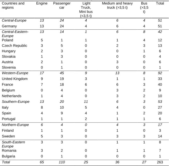
Because of the territorial focus of this paper, we don’t deal with the other great regions, but you can see the data in Table 1, which shows the different types of vehicle products according to countries and great regions for all of European settlements in 2013.
Table 1. Different types of vehicle products according to countries and great regions in the EU 28, 2013
Countries and regions
Engine Passenger car
Light Truck, Mini bus
(<3,5 t)
Medium and heavy truck (>3,5 t)
Bus (>3,5
t)
Total
Central-Europe 13 24 4 6 4 51
Germany 13 24 4 6 4 51
Central-Eastern- Europe
13 14 1 6 8 42
Poland 5 1 1 1 4 12
Czech Republic 3 5 0 2 3 13
Hungary 2 3 0 0 1 6
Slovakia 1 3 0 0 0 4
Austria 2 1 0 3 0 6
Slovenia 0 1 0 0 0 1
Western-Europe 17 45 9 13 8 92
United Kingdom 9 19 3 1 1 33
France 7 18 6 6 3 40
Belgium 0 4 0 3 2 9
Netherlands 1 4 0 3 2 10
Southern-Europe 13 20 11 6 3 53
Italy 8 10 5 4 0 27
Spain 4 9 4 1 2 20
Portugal 1 1 2 1 1 6
Northern-Europe 6 4 0 4 3 17
Finland 1 1 0 1 0 3
Sweden 5 3 0 3 3 14
South-Eastern Europe
3 3 0 1 1 8
Romania 3 2 0 1 1 7
Bulgaria 0 1 0 0 0 1
Total 65 110 25 36 27 263
Source: ACEA, 2013
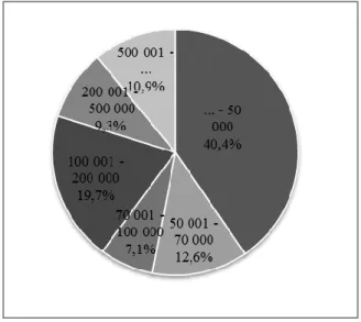
Based on the data of 183 European automotive settlements, it can be concluded that the 80 percent of this cities, towns and villages has got population of less than 200 thousand people, half of them are below 50 thousand inhabitants (Fig. 1).
This phenomenon can be explained that the automotive factories often prefer to the agglomerations of larger cities, and important port cities, not the core city. These agglomeration settlements administratively are not part of the larger city and their population is much more less.
Figure 1. Automotive settlements according to size categories in EU 28, 2013
Source: edited by authors based on ACEA (2013)
In EU 28 the population of smallest automotive settlement was 761 in the year 2011. Sandouville in France is located 20 km from the port city of Le Havre Nosovice, the other, extremely small automotive settlement can be found near Ostrava with less than 1,000 inhabitants. The biggest European cities with vehicle factories are Cologne, Prague, Munich, Barcelona, Vienna and Berlin. The population of these megacities was between 1 and 3,5 million in 2011. The highest population change brought to book Hordain in France, which could increase the number of its inhabitants by 24% in the period of 2001-2011, but it is worth nothing, that it means only about 300 inhabitants. Brasov, Craiova and Lovech have suffered the most drastic population decrease (approximately 20%).
Cluster analysis for the European vehicle settlements
In this chapter, we summarize the most important results of our cluster analysis for 178 European vehicle settlements.1 We have found, that optimal solution is 5 clusters and 7 variables. Table 2 shows the examined variables in order of importance in clustering.
1 Because of the lack of data we could involve 178 settlements. This is more than 82 percent of all European vehicle settlements.
Table 2. The examined variables according to spatial level, in order to importance in the clustering
Name of variables Spatial level Unit Year
(period)
1. Population density NUTS 3 person/km2 2011
2. Young age dependency ratio (0-14 / 15- 64)
NUTS 3 % 2012
3. Natural population change (compared to previous year)
NUTS 3 person/1000 inhab.
2011
4. Old age dependency ratio (65-x / 15-64) NUTS 3 % 2012
5. GDP per capita NUTS 3 EUR 2007-2010
6. Population LAU 2 person 2011
7. Net migration (compared to previous year) NUTS 3 person/1000 inhab.
2011 Search: www.citypoulation.de; http://epp.eurostat.ec.europa.eu
The following figure presents the size of the clusters.
Figure 2. Size of the clusters (number of units and percentage)
Source: edited by authors, 2014
The cluster 2, which includes the biggest and the most densely populated urban areas of Europe, could increase its population naturally and by migration as well. The age structure of the members is balanced. In this group we can find metropolitan areas, such as Berlin, Barcelona, Madrid, Munich and Vienna, moreover medium sized cities, such as Leeds Coventry and Poznan.
In the cluster 1, there are urban areas, which have got the highest GDP per capita in European comparison, the average population of the members is about 230 thousands, but their common problem and challenge may be the ageing of the society in the future. For example, Cologne, Nuremberg, Ulm, Mannheim, Leipzig, Dresden, Modena, Dingolfing, Sindelfingen, Neckarsulm, Sant'Agata Bolognese, and Stuttgart- Zuffenhausen belong to this cluster.
In order of quality, it is following the cluster 4, which is the most “youthful” in European comparison, its economic position is relatively favourable. This group usually consists of smaller (below 100 thousands inhabitants) cities, where the population could growth
by the migration and naturally as well. Some members of the group: Valkenswaard, Roeselare, Poissy, Molsheim, Bolzano, etc.
The members of the cluster 3 are facing serious challenges because of the extremely high (33,5%) old age dependency ratio and the natural population decline. At present, the average population is 116 thousands. In the economic point of view, the GDP per capita of this group is below average. This cluster includes for example, Ávila, Chemnitz, Foggia, Limoges, Saarlouis and Zaragoza, but surprisingly, Torino as well, with its 800 thousand inhabitants.
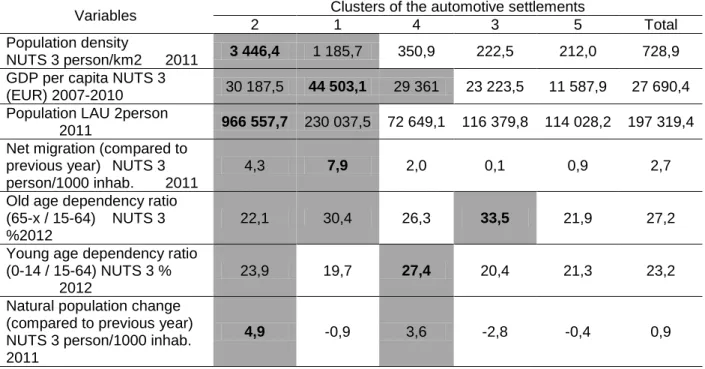
The members of the cluster 5 have got the weakest values. Economically, this group significantly falls behind the European average, its population stagnates or decreases.
The population density of the NUTS 3 areas is low enough. The average population of the cities is 114 thousands in this cluster. It can be mentioned as the “Visegrad Group”, because the so called “Visegrad countries (V4)”, named Hungary, Slovakia, Czech Republic and Poland give the largest part of this cluster (Table 3).
Table 3. Features of the clusters based on the values of all examined European automotive settlements, in order of quality2
Variables Clusters of the automotive settlements
2 1 4 3 5 Total
Population density
NUTS 3 person/km2 2011 3 446,4 1 185,7 350,9 222,5 212,0 728,9 GDP per capita NUTS 3
(EUR) 2007-2010 30 187,5 44 503,1 29 361 23 223,5 11 587,9 27 690,4 Population LAU 2person
2011 966 557,7 230 037,5 72 649,1 116 379,8 114 028,2 197 319,4 Net migration (compared to
previous year) NUTS 3 person/1000 inhab. 2011
4,3 7,9 2,0 0,1 0,9 2,7
Old age dependency ratio (65-x / 15-64) NUTS 3
%2012
22,1 30,4 26,3 33,5 21,9 27,2
Young age dependency ratio (0-14 / 15-64) NUTS 3 %
2012
23,9 19,7 27,4 20,4 21,3 23,2
Natural population change (compared to previous year) NUTS 3 person/1000 inhab.
2011
4,9 -0,9 3,6 -2,8 -0,4 0,9
Source: www.citypoulation.de; http://epp.eurostat.ec.europa.eu
Let us review the cluster membership in territorial aspects. In this point of view, the most dominant area in the cluster 1 is the Central-European region. The cluster 2 contains mainly Western-European automotive settlements. In the cluster 3 predominantly Southern-European and Central-European areas can be found. The cluster 4 principally includes Western-European settlements and the weakest cluster 5 can be identified by the Central-Eastern-European region, but some of South-and South-Eastern European areas belong to this cluster as well (Table 4).
2 More than total: grey mark, highest value: bold character
Table 4. Cluster membership in the great regions of Europe (%)
Great regions
Total Central-
Europe
Central- Eastern- Europe
Western- Europe
Southern- Europe
Northern- Europe
South- Eastern Europe
Clusters
1 78,1% 3,1% 3,1% 15,6% 100,0%
2 12,5% 25% 43,8% 18,8% 100,0%
3 38,2% 2,9% 8,8% 47,1% 2,9% 100,0%
4 77,8% 7,9% 14,3% 100,0%
5 78,8% 12,1% 9,1% 100,0%
Source: www.citypoulation.de; http://epp.eurostat.ec.europa.eu
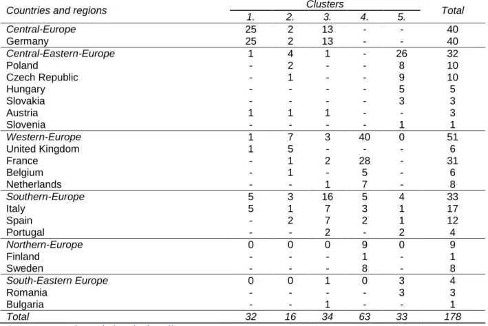
The following table shows the number of automotive settlements, according to countries and great regions within the clusters. (Table 5) This classification helps to understand, how strong the location can be determine the economic position and development opportunities.
Table 5. Number of automotive settlements, according to countries and great regions within the clusters
Countries and regions Clusters
Total
1. 2. 3. 4. 5.
Central-Europe 25 2 13 - - 40
Germany 25 2 13 - - 40
Central-Eastern-Europe 1 4 1 - 26 32
Poland - 2 - - 8 10
Czech Republic - 1 - - 9 10
Hungary - - - - 5 5
Slovakia - - - - 3 3
Austria 1 1 1 - - 3
Slovenia - - - - 1 1
Western-Europe 1 7 3 40 0 51
United Kingdom 1 5 - - - 6
France - 1 2 28 - 31
Belgium - 1 - 5 - 6
Netherlands - - 1 7 - 8
Southern-Europe 5 3 16 5 4 33
Italy 5 1 7 3 1 17
Spain - 2 7 2 1 12
Portugal - - 2 - 2 4
Northern-Europe 0 0 0 9 0 9
Finland - - - 1 - 1
Sweden - - - 8 - 8
South-Eastern Europe 0 0 1 0 3 4
Romania - - - - 3 3
Bulgaria - - 1 - - 1
Total 32 16 34 63 33 178
Source: www.citypoulation.de; http://epp.eurostat.ec.europa.eu
As we have shown the Central-Eastern European countries have the second largest cluster membership. However compared to the average of the European countries the economically most backward cluster cities forming the decisive majority of the Central- Eastern-Europe countries. Into these countries belong the so-called Visegrad counties (V4) as Hungary, Slovakia, The Czech Republic and Poland. But from this four
countries except Poland, the remaining three belong to the centrope region as Austria also.
Within the framework of the centrope region in 2010 begun and 2012 ended Infrastructure Need Assessment Tool titled project has been studied the region’s traffic network, bottlenecks and future traffic. All this has showed that the region will facing with serious traffic problems, if the current trends do not change. All this can have a significant impact to the economy including to the automotive clusters as well.
Therefore in the future the automotive cluster could be stronger in the Central- Eastern-European region and remain competitive with the neighbouring European countries it’s absolutely necessary the development of transport infrastructure.
Possibilities in the transport development
Since the 2003 foundation of the centrope region always played an important role in the region’s life the transport development issues. However not just in the population have arisen to the transport related needs, but also in the cross-border traffic concerned all actors. All this has further increased that in recent years significant economic and functioning capital investment increase has showed the region. And along with this the European cross-border traffic average well above has been increased the cross-border traffic in the centrope region which also shows well the territorial and economic integration of the region. Because the centrope region not only as transport node significant in Europe but also more transnational transport corridor passes through it, therefore in order to improve its competitiveness it’s necessary to develop of its transport connections. However this would lead not only to significant passenger car and truck traffic in the borders of the centrope region, but it will be affecting every field (water, air, rail) of the transport (INAT 2012).
All this has been recognized by the centrope regions also, and taking into account the sustainability, environmental protection, and economic, they have decided to develop a common strategic framework to the development of the transport infrastructure and public transport. Because the centrope region is not functional without appropriate transport connections, which are playing an important role form the aspects of the commuters, the economic integration, and the labor market mobility. Due to this has been created within the framework of the cenrope capacity project the “Infrastructure Needs Assessment Tool” (INAT) pilot project. As the first step of the project the centrope partner regions (Burgenland, Lower-Austria, Vienna city, South Moravia, Győr-Moson-Sopron County, Vas County, Bratislava and Trnava region) of the four countries (Austria, Czech Republic, Hungary, and Slovakia) has mapped their current development programs and transport conceptions and the future traffic demand and supply expected bottlenecks and the available cross-border planning tool kits. After this has been prepared the first such common maps form the centrope region which showed its transport network and its current problems and weaknesses. And as second step the four countries partner regions and cities has been made a common strategic framework which included the needs of the future cross-border public transport and infrastructure development.
The main results of the centrope mapping
As already has been mentioned the cross-border traffic growth was one of the first proof to the dynamic integration of the centrope region. Based on Austrian forecasts for example on the common borders of Austria with the centrope countries the
passenger car traffic even could grow by 135% until 2025, while on the other border sections at most 21% growth can be expected. In our research can be highlighted that the freight traffic also where without change of the current trends between 2025 and 2030 the road transport could by 120%, the rail by 55%, and the water by 51% grow.
And on Hungary similar to the Czech Republic and Slovakia if does not take place the development of the public transport, due to the motorization process in the whole centrope region by 30-40% will grow the number of the passenger cars by 2030.
Therefore it’s especially important that the public transport development starts not just on regional, but also on transnational level. Because the passenger car traffic will definitely increase, but to the effect of the political change “only” with 98% which is important difference compared to the trend scenario’s 135% growth (Lutter–
Sauskojus–Wolffhardt 2012). On the other hand with a few exceptions the cross- border public transport is not competitive in the centrope region.
However the biggest obstacle of the cross-border public transport development is the legal, institutional and financial framework. Because from the four countries of the region in Hungary and Slovakia there is no transport association at the moment, which would make allow that the cross-border integrated public transport service could be created. Another problem can also be identified that there is no passenger-friendly available system in multiple languages regarding to transport information or either ticket machine of any countries. And there is no harmonized schedule, which should be one of the basic conditions to the centrope integrated public transport development.
But not only due to the passanger car number increase are urgent the public transport development. The increased cross-border traffic primarily is due to that five transnational transport corridor (TEN-T) crosses the centrope region, and further two expansion proposals initiated by transnational EU project have been also added to the centrope map. One of these is the Central European Transport Corridor (CETC), and the other is the South-East Transport Axis (SETA).
At present the greatest issue of the centrope region is that there is not an appropriate north-south connection. Therefore to the extension recommended CETC and SETA corridors would serve to the elimination of this deficiency. It should be definitely note that both corridors only in Hungary running through together. The CETC axis starting from Sweden would be mean a north-south connection between the Adriatic and Baltic areas. And the specialty of the SETA is that it would be starting from the node of the centrope region passing through TEN-T corridors, which is Vienna city (INAT 2011). At the same time similar to the CETC it would provide into the direction of the Adriatic axes a southward connection. Which is also common in the two corridors that they endpoint is in Croatia the port of Fiume, and in Slovenia the port of Koper. On 1 July 2013 Croatia has joined to the European Union so it can be assumed, that both recommended north-south direction axes will be accepted by the European Commission and will be added to the transnational transport corridors. Therefore in the future to Hungary it will be a particularly important task by the corridor designated on the track can be found railway and road infrastructure development.
The transnational transport corridors showing well that the primarily linear infrastructures, the railway and the road network development will be especially important in the centrope region. Therefore to both network from the four countries current traffic data have been determined by 2025 expected capacity utilization.
Figure 3. Railway capacity utilization in the centrope region 2025
Source: INAT (2012)
From the railway capacity utilization 2025 forecast clearly turned out that without development intervention the region will be facing serious capacity problems (1.figure). And these bottlenecks in most cases are covering the main routes.
Therefore it would be especially important into southeast direction the Vienna- Budapest, into southwest direction the Vienna-Graz, into the west direction the Vienna-St.Pölten, and into north direction the Vienna-Brno-Prague and Brno-Ostrava lines development. But next to the railway lines it’s an especially important task the modernization of the transport nodes in the densely populated and in the industrialized nodes (INAT 2011).
Because Vienna is the node of almost every the region passing through TEN-T corridor, it’s not accidental that the highest traffic can be concentrating around Vienna city. Among others is due to this that the construction of the Vienna main railway station has begun in 2009, which completion can be expect on 2015.
In last July Croatia joined to the European Union so in addition to the centrope region typical east-west traffic in the future the north-south traffic could also increase significantly, which primarily will be affect the Czech Republic, Slovakia, and Hungary.
And in order to ensure that the region’s economy could remain competitive not only the development of the tracks and the stations are required but of the freight terminals also. In the case of Vienna and Bratislava are also have been plans for the building of multimodal freight terminals, but it would be also important the development of such a smaller logistic centres like the Győr-Gönyű harbour in Hungary (INAT 2011).
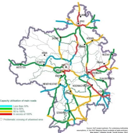
Similar to the railway, the capacity utilization of the roads also have been determined by 2025. What from the map clearly (Fig. 4.) turned out, that Vienna, Brno and Bratislava agglomeration must be facing significant traffic if not taking place intervention into the primary road network development. Along with this not just the region’s external but internal accessibility will be also problematic. Because on the already mentioned primary road network relatively high traffic overload can be expect.
Figure 4. Road capacity utilization in the centrope region 2025
Source: INAT (2012)
All this is especially true to the primarily road sections between Vienna and Brno, Bratislava and Trnava, and from Brno to Prague and into north direction to Blansko, and east direction to Ostrava which is not constructed yet (INAT 2011). And it’s also true to the larger part of the Hungarian road network, where traffic capacity problems can be expected until 2025. In the case of Hungary it’s all due to the significant backlog in motorway construction, because an east-west and north-south direction motorway would be much needed. And as it can be seen in the Figure 4, the north- south axis (Brno-Bratislava-Hegyeshalom-Csorna-Szombathely) will be also having a significant traffic. And now that Croatia is also the member of the European Union an even greater capacity increase can be expect on this rout. Therefore the development of this axis would be an especially important task in the future. Because not only the passenger traffic, but the fright traffic could increase significantly in the affected countries such as the Czech Republic, Slovakia, and Hungary.
But from the capacity utilization study turned out that until 2025 planned road developments will eliminating the significant part of the bottlenecks, but the large agglomeration areas will be remaining still critical areas. Therefore the problems of the capacity utilization can’t be solved only with road construction, but at least it’s needed the public transport development also. And this development should be affecting not just the road, but the railway, waterway, and air transport too (INAT 2011).
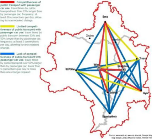
The cross-border public transport supply between the more than 50.000 person populations numbered cities in the past 10 year rather has a lot improved. This improvement at the same time concerning almost only to the large cities of the centrope, because there are more and faster connection from Vienna to Bratislava, Győr, and Sopron, and between Bratislava and Brno. Our research has also
highlighted form the findings that from the passenger car traffic also, which between those cities has been increased significantly, however due to the appropriate route density and travel time on those directions the public transport is competitive with it (INAT 2011) (Fig. 5).
Figure 5. Public transport in the centrope region, 2011
Source: INAT (2012)
But among on the peripheries can be found towns, where the public transport supply is still wrong. On those areas the travel time can be even 50% more as with passenger car, the routes are rare, and it happens that not just one time must be changing during the travel (Lutter–Sauskojus–Wolffhardt 2012). A good example to this the case of Győr and Bratislava where at the moment is not appropriate public transport connection, despite that Vienna can be found much farther from it. But it can be say similar for example from the St. Pölten-Trnava, the St.Pölten-Brno and the St.Pölten-Szombathely connection, where the travel time is 50% longer with public transport than with passenger car. Or the connections per day are less than 5, and more than one change is needed. However on the Trnava-Vienna, Győr-St.Pölten, Brno-Sopron and Brno-Trnava routes is not better the situation, because the travel time with public transport is 33-50% longer than with passenger car, and besides of the minimum 5 connections per day one change is required. At Győr in any case must be noted also the lack of the competitive public transport with Trnava. This connection could not just the Slovakian-Hungarian but the Brno-Győr Czech-Hungarian connections strengthen also. Because Hungary has at the moment into the direction of the Czech Republic the worst public transport connections.
And if in the future will not preventing or at least following the road development the railway network development then the public transport will fall back significantly against to the passenger cars.
The transport mapping of the region besides of the road and railway also covers the waterway, air and bicycle traffic too. The primary waterway in the centrope is the Danube, which from the aspect of passenger and freight traffic also a significant route.
And in the last few years’ powerful growth were observed primarily in the utilization of shuttle boats and touristic boats. But the most significant connection meant in the passenger traffic the TWIN City Liner. Namely this project had started scheduled shipping between Vienna and Bratislava.
But the freight traffic stagnates on the Danube because it hasn’t been managed yet the scheduled freighter traffic developed in the centrope region. Additional problem means also that until today it doesn’t happened the rehabilitation of the Danube and setting of the water level. Because on some parts of the river in the case of low water level bottlenecks has been creating. The Danube side logistics chains construction is still pending, but this includes the European Union’s strategy (INAT 2011).
Regarding to the air transport the most important airport in the region is the Vienna airport however, the Bratislava airport has also significant traffic. In the future both plans the capacity expansion but related to the Schwechat airport it must be definitely noted that after the construction of the main railway station its role will be more significant in the centrope. As well if the airport’s rail connection with Götzendorf will be ready, then it will connect to an international network (INAT 2011).
Related to the bicycle traffic it can be said that currently more international bicycle route crosses the centrope region which are the following (Lutter–Sauskojus–
Wolffhardt 2012):
Euro Velo 4 Central European route: Between Roscoff and Kiev through Brno
Euro Velo 6 Rivers route: Atlantic Ocean to Black Sea
Euro Velo 9 Amber Route: Baltic Sea to Adriatic Sea
Euro Velo 13 Iron Curtain Trail: Barents Sea to Black Sea
These routes are highly significant primarily from touristic aspect. And the most popular from each Euro Velo route the number 6 Rivers route which follows the line of the Danube. Therefore in the future will be especially important the local and the regional bicycle infrastructure continuous development together with the recently created online website. Namely on this website not just from the Euro Velo network can be found information but from the attractions of the centrope region and from the actual events too. This must be completed later with the information of the accommodations and the touristic centers.
From the mapping of the centrope transport infrastructure it turned out clearly that in the future with numerous challenges could face the region if the current trends will continue. All this made even more difficult that one of the basic condition would be of the competitive cross border public transport, the creation of regional expanse transport association in Hungary and Slovakia. This kind of association exists for now only in Austria and in the Czech Republic. However one of the biggest obstacles of the Hungarian transport association creation is the lack of creating the relevant legal background. And without transport association can’t be created for example such unified pass or ticket system which is valid in each region of the member states.
Failing that as already has been mentioned can’t be competitive public transport in the centrope region.
The potential benefits of Győr-Moson-Sopron and Vas County centrope development
As at the end of the previous chapter has been mentioned after the mapping of the centrope region the four country has made the transport and infrastructure development strategic framework of the centrope. This document has each member region and cities of the centrope accepted. In the framework between the goals of the
“Infrastructure Vision 2030” are listed the cross-border harmonized and local transport infrastructure development. The role of this 2030 vision is double on the one hand it serves the transnational level lobbying on the other hand supports each region in the their own (road, railway, waterway, air, etc.) development realization.
Among the 2030 visions highlighted role have become the road and railway network related to development goals. That is not accidental because as it was shown, with the primary capacity problems will be facing the road and the railway infrastructure. This is on the one hand due to the dynamic economic integration of the region, and on the other hand that more transnational transport corridor (TEN-T) also crosses it. And all these will be generating significant traffic growth in the future.
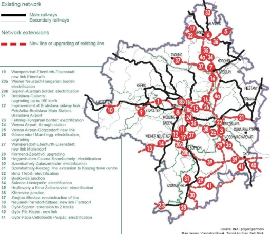
During the railway network 2030 vision not just the capacity growth was the aim, but the travel times reduction also (Fig. 6). The vision therefore includes among others the high-speed lines, the current regional lines to be transformed into main lines as well as the more efficient network nodes (Lutter–Sauskojus–Wolffhardt 2012). And all this developments will be contributing to the capacities expansion, the travel time reduces between the major cities of the centrope, and within the whole region the accessibility and public transport competitiveness improvement.
Therefore the centrope partner regions are agree with the proposal of the European Commission about the TEN-T corridors, but in order that in the future could remain the railway competitive it would be necessary for the core network the inclusion of some railway line which is currently not a part of it. Such a track would be the Vienna – Vienna Airport – Bratislava – Bratislava Airport line which integrates the airports of Vienna and Bratislava into the whole region high-level railway system. From Austrian side the Ostbahn line between Götzendorf and Pandorf and the north-south connection trough Bratislava on to Hungary by other plans are already part of the proposal (INAT 2012).
The priority axis No. 22 Prague – Vienna/Bratislava – Budapest – Athens and the Baltic – Adriatic axis Gdansk – Vienna – Bologna intersects at Brno. Therefore it would be especially important the addition of this node to the core network. Even before Croatia’s accession to the EU the centrope regions have thought it would be necessary the missing links of the SETA corridor from Vienna/Bratislava to Croatia incorporated into the TEN-T network (Vienna/Bratislava – Zagreb railway line).
Because the existing railway line has typical poor technical standards and low-speed sections, which are unable to offer high-quality service to Croatia. Hungarian side is therefore necessary to add to the TEN-T the Hegyeshalom – Szombathely, Körmend – Zalalövő, and the Szombathely – Zalaszentiván sections. And the importance of the SETA corridor will further increase that it will reduce the current six hour travel time to four hours between Vienna/Bratislava and Zagreb. From this development Hungary can benefit the most on the Vienna-Szombathely line (INAT 2012).
In the area of the Cold War and Iron Curtain several regional railway connections were closed. However, in order to strength the cross-border connections of the centrope regions it would be worthwhile to revitalize these lines. Although the reconstruction is not an easy task because the tracks were removed, and the land has became private ownership. However among others the SETA project could make justified that for
example between Austria and Hungary the Oberwart – Szombathely line reconstruction could begin. Because this development could increase not just the accessibility of Southern Burgenland as the cross-border region of the future, but it could increase the central importance of Szombathely (INAT 2012).
Figure 6. The 2030 railway network vision of the centrope
Source: INAT (2012)
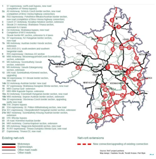
The road 2030 infrastructure vision similar to the railway aims the reducing of the capacity constraints, increasing the quality of the services, reducing the environmental impact on the settlements and the elimination of the safety problems. The 2030 long term vision therefore includes the elimination of gaps in the existing expressway/motorway network, the creation of new high-level connections, and the construction of bypass roads in order to reducing the traffic load on the urban areas (Lutter–Sauskojus–Wolffhardt 2012) (Fig. 7.). Due to these developments for example with 30% will be decrease the travel time between Vienna and Brno, and will reduce the environmental pollution in the villages (INAT 2012).
From the aims of the visions the most important affecting the areas of Hungary, which is primarily due to that from the four countries there is the most significant backlog on the field of motorway construction. Especially large deficits are the M15 and M86 motorways. Namely these motorways would ensure north-south connection until Slovakia on Bratislava- Mosonmagyaróvár-Csorna-Szombathely-Nagykanizsa track.
Secondly the M15 and M86 motorways would be the already mentioned Central European Transport Corridor (CETC) Hungarian sections. So, the current passenger and freight traffic of the M86, which have resulted in serious problems for to the cities and the smaller towns as well, should be shifted to the motorway. Finally, this year on
July 1 to the European Union joined Croatia with would be significant connection (INAT 2012).
The centrope partner regions in relation to the road network development also accepting the existing TEN-T proposal of the European Commission. However it would be necessary to pick up between Vienna and Bratislava trough the S8 and D4 realizing motorway into the priority rank connections of the TEN-T. Because this link is part of a regional Vienna – Bratislava ring-road system tasked with splitting the growing volume of Vienna – Bratislava intercity traffic between two routes. And as it already has been mentioned, the Bratislava-Mosonmagyaróvár-Csorna-Szombathely- Nagykanizsa track is also recommended to add to the Trans-European core network, because it’s a part of the CETC and ensure significant connection to Croatia (INAT 2012).
Figure 7. The 2030 motorway and main road network vison of the centrope
Source: INAT (2012)
What it should be highlight also, is the lack of the M85 motorway between Győr area (M1) - Csorna - Nagycenk - Sopron - (Austria). The first section of this road the Enese bypass road has been completed in 2011 and the Csorna bypass road is under construction which excepted completion is 2015. However it would be necessary to build this motorway as soon as possible, because after Hungary has joined the European Union the traffic of the current No.85 road has increased significantly. All this is primarily due to the increased traffic into the direction of Austria which in both direction will continue to increase in the future. Therefore the construction of the M85 first of all from the trucks and the freight traffic could be exempt the existing main road,
and as well the settlements (especially Csorna) from the increased traffic, which had more than once led to serious accidents.
But it should be not forget the M1 motorway neither, which development though not includes the 2030 vision, but as it could be seen its capacity utilization will be exceed even the 100% without development interventions. Therefore, it would be appropriate as soon as possible the existing 2x2 lane motorway expand into 3x3 lane.
The Danube means an important transport corridor in the field of freight traffic and as well in the passenger traffic as well. And at the same time it’s the 18th priority project of the TEN-T, and it plays an important role in the Danube-region strategy of the European Union. The centrope regions therefore not accidentally supporting the EU’s Danube-region strategy which includes the following main points (INAT 2012):
- Increase cargo transport by 20 % by 2020 compared to 2010
- Solve obstacles to navigability, taking into account the specific characteristics of each section of the Danube
- Establishment of an effective waterway infrastructure management
- Development of efficient multimodal terminals at the river ports (Vienna – Freudenau, Bratislava harbour, Gönyü harbour)
- Implementation of a harmonised River Information System (RIS) and ensuring the international exchange of RIS data
The other big project which means a significant milestone in the navigability development of the Danube within the centrope region is the “Large scale river engineering project between Vienna and Bratislava”. The river ports traffic and the attractiveness of the waterway transport the following measures shall be enhance (INAT 2012):
- Further capacity extension of the trimodal freight terminal of Vienna - Extension and modernisation of the freight terminal Bratislava - Extension and modernisation of smaller ports as well (e.g. Krems)
- Enabling the navigability of the branch of the Danube between Gönyü and Györ for passenger ships, taking into account the requirements of the ecosystem And beside of these each member region of the centrope aims with the ports development connected Danube passenger transport development.
Relation to the airports in the region primarily the Vienna and the Bratislava airport has key role. Both airports are functioning as an international airport, and in both cases are planned the capacity expansion, the development, and the improvement of their availability.
Conclusion
The significance of the automotive industry is transparently articulated in our research, which demonstrated the extremely important role of this particular type of business in the economy of the Central- and Eastern European region. Regardless of the dynamic development of the automotive industry in that region the symptoms of legging behind to the western part of Europe is also displayed. From this point of view the CEE countries belong to the periphery. A break point may be the development of the infrastructure network, which would improve the economic integration among these countries.
A significant growth of the traffic between the member regions of the centrope countries has proved the dynamic integration of the centrope region. The other factor, which contributed to successful integration, is the efficiency of more transnational transport corridor crosses. A greater traffic growth can be expected in the future
between the four countries, which is also displayed in the Austrian cross-border traffic forecast. The member regions of the centrope have also recognized this particular factor, which trend has already been identified in the first transport infrastructure mapping of the whole region. This particular mapping clearly shows that without the changing of the current trends the whole centrope area will be facing serious capacity problems regarding the freight and road traffic services. Therefore beside the development of the transport infrastructure networks the same emphasis must be implemented to the public transport development.
This particular transport development project offers tremendous opportunity for the Central-Eastern European countries representing the weakest indicators at the moment to be shifted into strongest clusters direction.
References
Barta,Györgyi (2012) Central and Eastern European automotive industry in European context.Manuscript, Győr. In: Rechnitzer, János – Smahó, Melinda (ed.) (2012) Vehicle Industry and Competitiveness of Regions in Central and Eastern Europe. Széchenyi István University Universitas Nonprofit Ltd., Győr 2012. pp. 33-70.
CENTROPE pilot project “Infrastructure Needs Assessment Tool – fostering competitive regional development” 6. May 2012 http://www.centrope.com/hu/centrope-projekt/kiserleti-projektek-2010- 2012/infrastrukturaertekelo-eszkoz
Hardi, Tamás (2012) A közúti járműgyártás szerepe a kelet-közép- és délkelet-európai ipari térségek kialakulásában. In: Rechnitzer, János – Smahó, Melinda (szerk.) (2012) Járműipar és regionális versenyképesség. Nyugat- és Közép-Dunántúl a kelet-közép-európai térségben. Széchenyi István Egyetem Universitas Nonprofit Kft., Győr, pp. 99–108.
INAT (2011) Mapping Infrastructure Status quo and Improvement Initiatives. Academia Istropolitana Nova [etc.], Bratislava [etc.]
INAT (2012) Strategic Framework for the Transport and Infrastructure Development in the centrope region. Academia Istropolitana Nova [etc.], Bratislava [etc.]
Losoncz, Miklós (2012) A kelet-közép-európai járműipar piaci környezete. In: Rechnitzer, János – Smahó, Melinda (szerk.) (2012) Járműipar és regionális versenyképesség. Nyugat- és Közép- Dunántúl a kelet-közép-európai térségben. Széchenyi István Egyetem Universitas Nonprofit Kft., Győr, pp. 64–98.
Lukovics, Miklós – Savanya, Péter (2012) A visegrádi országok megyéinek versenyképessége a járműipar szemszögéből. In: Rechnitzer, János – Smahó, Melinda (szerk.) (2012) Járműipar és regionális versenyképesség. Nyugat- és Közép-Dunántúl a kelet-közép-európai térségben.
Széchenyi István Egyetem Universitas Nonprofit Kft., Győr, pp.230-262.
Lutter, J.─Sauskojus, J.─Wolffhardt, A. (szerk.) (2012) centrope Infrastructure Needs Assessment Infrastructure & Transport Development – from Strategy to Action. centrope, Vienna
Rechnitzer, János – Smahó, Melinda (ed.) (2012) Vehicle Industry and Competitiveness of Regions in Central and Eastern Europe. Széchenyi István University Universitas Nonprofit Ltd., Győr 2012.
p.301.
Database
ACEA – European Automobile Manufacturer's Association (2013) http://www.acea.be/
City population (2013) www.citypoulation.de Eurostat (2014) http://epp.eurostat.ec.europa.eu