University of Sopron Faculty of Forestry
Kitaibel Pál Doctoral School of Environmental Science
Thesis booklet of doctoral (PhD) dissertation
Analysing Changes and Character of the Őrség Landscape
Pál Balázs
Sopron
2017
Doctoral school: Kitaibel Pál Doctoral School of Environmental Science
Program: Bioenvironmental Sciences Supervisor: Prof. Dr. Éva Konkoly-Gyuró
university professor
Aims of the dissertation, research questions
The research reveals the character of the Őrség landscape and presents the changes of its land cover from the mid-18th century till today, emphasising the impacts of the border defined in 1920 on the landscape and its character. The relevance of the topic is given by the tasks arising from the European Landscape Convention and from the actual Landscape Strategy of Hungary (2017-2026), where identifying landscapes and analysing their characters have advanced significance (Council of Europe 2000; FM 2017). The research was done between the birth of these two important documents, mainly within the scope of the TransEcoNet international project aiming to develop and manage the ecological network. The research aims to provide information for the preservation, management and planning activities of this highly valued, unique landscape.
Research questions are the following:
Borders of the landscape:
Where does the border of Őrség lie according to local people and the scientific literature?
Has the political border influenced the conception of the local people about the borders of Őrség?
Character of the Őrség landscape:
What are the characteristics of the Őrség landscape in the views of local people and experts?
Are there any relations between the borders of the character units and the conceptions of the local people about the borders of Őrség?
Changes of the landscape:
How have the land cover and the pattern of the landscape changed?
How do local people consider changes of the landscape?
Role of the national borders in forming the character and the changes of the landscape:
Does the character of the present and the past landscapes differ on the Hungarian and the Slovenian side of the border?
What are the reasons for the differences appearing in the present character of the landscape?
Materials and methods
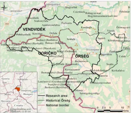
The main principle of the research area was the historical Őrség embracing 18 settlements that received privileges for defending the frontier (Beluszky 2005) (Figure 1).
Figure 1: Situation of the research area. Base map: OpenStreetMap
Further principles of the definition of the research area were the comparability of the Hungarian and the Slovenian sides of the border.
This led me to determine the width of the research area in two settlements along the Slovenian-Hungarian border. The area contains three landscapes: Őrség, Vendvidék and the Slovenian Goričko. The whole area is characterized by significant forest cover (65%) and rich in natural and cultural elements. Both sides of the border are under nature protection.
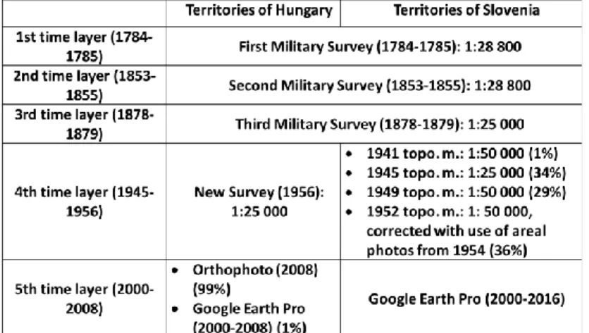
Landscape changes are revealed mainly through historical map processing. During map-processing, military surveys were analysed (Table 1). An orthophoto from 2008 was the source of actual land cover information for Hungary, and Google Earth images were the source of actual land cover information for Slovenia.
Table 1: Maps and aerial photographs used in the landscape change analyses on the Hungarian and the Slovenian side of the border During map processing, land cover information was recorded as a vector layer with a three-level category system (Konkoly-Gyuró et al. 2011). Land cover maps were checked thematically and geometrically. Then they were analysed through column charts and transitions matrices, which clearly show the transformations of the
land cover categories between the two maps. Beside classical statistical solutions, trajectory analysis was applied, which made it possible to analyse and typify the changes simultaneously for the whole time period (Skokanová 2009).
Landscape change information derived from historical maps, scientific literature, statistics, and contemporary photographs were supplemented by further information derived from interviews with local, mostly elderly people. Before each conversation, interviewees indicated the borders of the Őrség on a sketch map. These “mental maps” provide information about the landscape borders living in the mind of the interviewees. These borders can be compared to the results of the landscape character assessment (LCA). The character of the landscape was revealed through the method developed and applied for the Fertő-Hanság region (Konkoly-Gyuró et al. 2010), which is based on the methodology of Swanwick - Land Use Consultants (2002). This method combines geoinformatic analyses and field surveys. Geoinformatic processing is based on complex attributes of the three basic properties of the landscape (relief, human impact, land cover dominance), in which information from field surveys is integrated. Character types of the landscape can be distinguished on the basis of these three complex properties.
Theses derived from results
1. Borders of the Őrség based on the mental maps
The borders of the historical Őrség are considered as the actual landscape border according to statements of local interviewees.
However, on the mental maps they differ from this (Figure Figure 2).
Figure 2: Settlements of Őrség identified by the interviewees The Hungarian-Slovenian border divides the historical Őrség and it also divides the opinion of the interviewees about the present boundary of the Őrség. However, according to the mental maps, there are settlements among the former privileged villages situated today in Slovenia that are considered as Őrség by only one third of the interviewees. Simultaneously, according to the mental maps, the area of the Őrség on the Hungarian side of the border extends much further than the historical Őrség. The reason for this might be found in the former administrative units (Őrség district, and Őriszentpéter district), which included settlements also outside the historical Őrség.
Step by step these units have built into the mind of the people, so it can be that Magyarszombatfa and Velemér situated south of the historical Őrség, and also Viszák and Őrimagyarósd lying north- east are an organic part of the Őrség according to the interviewees.
2. Character of the landscape
The character of the present Őrség landscape is not homogeneous. It consists of more character types on both sides of the Slovenian-Hungarian border (Figure 3).
Figure 3: Landscape character types of the research areal
Character types differ from each other in their relief, land cover, usage intensity and settlement structure properties. Today, the political border also represents a boundary in the landscape, in which the accelerating afforestation and the consolidation of agricultural holdings in Hungary during the 20th century played a significant part and caused visible differences on the two sides of the border.
Factors particularly endangering the uniqueness of the Őrség landscape are the transformation of the mosaic-like landscape, which can be brought into connection with abandoning grasslands and arable lands and also with expanding forest areas. Further negative tendencies are the abandonment of orchards and the disappearance
of traditional the architectural style and local settlement structure called “szer”.
3. Land cover information of the First Military Survey in Őrség
The First Military Survey was compared to a contemporary map to validate proportion of grassland-arable land to forests (Table Table 2).Table 2: Cross-check of land cover information of the Csörötnek settlement in 1784 and 1785
The reason for the significant differences could be the different scale, the georeferencing difficulties and the thematic inaccuracy of the military survey. Based on the analyses the real proportion of the most questionable grassland category could be double of the area represented on the military map. Certain grasslands might have been surveyed as arable lands.
Land cover type
Proportion (%) First Military
Survey 1784
Proportion (%) Kenedics's map
1785
Difference in proportion (%)
Urban fabric 9.59 4.90 -4.69
Arable land 56.61 49.86 -6.74
Vineyard, orchard 6.05 1.53 -4.52
Forest 20.92 34.49 13.57
Grassland 2.81 6.08 3.27
Wetland 0.48 -0.48
Open water surface 2.43 3.14 0.71
Bare surface, other 0.65 -0.65
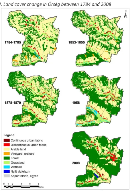
4. Land cover change in Őrség between 1784 and 2008
Figure 4: Land cover change of the territory identified as Őrség by 90% of the interviewees
According to the land cover analyses of the Őrség sample site including four settlements (Szalafő, Őriszentpéter, Bajánsenye and Kercaszomor), the area has changed a lot during the past two hundred plus years (Figures Figure 4:-Figure 5).
Figure 5: Land cover change of the territory identified as Őrség by 90% of the interviewees
Decreasing proportion of arable lands (59.1%->22.8%) and expanding forest areas (25.3%->62.3%) give the most relevant changes. The proportions of these two land cover categories were reversed during the period under survey. Besides these tendencies, the proportions of grasslands (19%->9.6%) vineyards, and orchards outside of the settlements (1.5%->0.2%) have decreased. First, arable lands and grasslands situated far from the settlements mostly at higher elevation have been replaced by forests. Parallel with expanding forests, the mosaic-like structure of the landscape has been reduced, which is indicated by the decrease of the length of
edges between forest and non-forested surfaces. Today, only 57% of the length of edges of the mid-19th century can be detected.
5. Typifying land cover changes on the two sides of the frontier
Stable trajectories on the Hungarian side (19.4%) have a greater proportion than the Slovenian side of the border (Table 3). Stable areas are forests and arable lands in both countries. The most significant differences among areas with stable trajectories are the proportion of continuous grassland cover in Hungary (1.7%) which is much greater compared to the Slovenian value (0.1%). Territories lying at lower elevations show higher dynamics in both countries: in Slovenia stable trajectories are clearly situated at higher elevations.Table 3: Land cover change trajectories (extent, proportion and average elevation in metres above sea level) of the Hungarian and the Slovenian
territories between 1784 and 2008
6. Role of the frontier in the landscape change
Proportion and configuration of the land cover of the areas situated at lower elevations were homogenous before the new national border was defined by the Treaty of Trianon. The proportion of arable lands remained higher by the mid-20th century on the Yugoslav side compared to the Hungarian side of the border. Today, arable lands differ in their configuration in both countries. On the Hungarian side, we can see arable lands with greater plots at every elevation thanks to their consolidation, while in Slovenia tiny parcels have remained. Unity in the Kerka-valley also remained in the mid-
km2 %
Average m a.s.l.
(m) km2 %
Average m a.s.l.
(m)
Stable 44.4 19.4% 285 11.9 13.5% 308
Quasi-stable 77.4 33.9% 284 28.8 32.5% 304
Stepped 17.9 7.8% 281 5.3 6.0% 302
Cyclical 14.8 6.5% 282 7.6 8.6% 305
Dynamic 41.4 18.1% 273 20.4 23.0% 291
With no constant trend 32.6 14.3% 273 14.6 16.5% 293 Change trajectories
Territories of Hungary Territories of Slovenia
20th century owing to the intense agricultural utilization in both countries. However, on the Slovenian side, arable lands were characterized by a much higher intensity of usage. There is a smaller proportion of grasslands, and built-up areas (mainly transportation infrastructure) have significantly increased, which resulted in a different landscape character.
Conclusions, suggestions
During the last circa 250 years, the Őrség landscape has shown expressive changes. Among these changes, the large-scale expansion of forest areas can be highlighted. According to the National Forest Strategy (2016-2030), increasing the forest areas of Hungary is a strategic goal (FM 2016). However, a further increase of the forest cover of Őrség is undesirable because it could lead to the loss of the remaining mosaic-like landscape structure.
Results of the landscape character assessment can contribute to a regional or nation-wide analysis besides the utilization at local level.
Through LCA executed on a larger area, the landscape character types are clearly distinguishable. Based on their unique occurrence, landscape character areas could be determined, among them an individual Őrség landscape character area.
Beside the analyses presented in this research, the generated digital historical map series can be used by other researchers in additional studies. Among others, the dynamics of land cover changes can be cross-checked with present nature protection areas or with point-map of valuable plant species. Such investigations could give us an answer to the question of how species indicate the stability or continuity of the land cover of a given habitat.
Land cover maps together with meteorological data can be used for analyses of climate change. Local scale analyses can be made using the more detailed land cover category system.
Inserting further land cover maps into the map series analysis can be refined. In the first place 20th century maps are needed, to fill
the approximately 50-60 year gap between the maps. New time layers could contribute to a more detailed analysis of the accelerated tendencies of the 20th century, caused by the rapid development of agricultural and transportation technology and the increased usage intensity.
Through a more accurate land cover map, satellite imagery or aerial photography monitoring land cover would be possible, to analyse further changes of the landscape. Fundamentally, interviewees considered the Őrség landscape as positive. It is also clear, that they are very fond of it. However, local people consider landscape changes to be negative. In their opinion, everything was better in the old times, and by today everything has turned in a bad direction. This highlights the future planning directions. What they consider as ideal should be established, and what remains of this should be preserved. This is possible, since the local people’s devotion to their landscape and their love of nature are the greatest in Őrség. Building upon this, the heritage preserved by the Őrség landscape through centuries could live on through the contribution of the inhabitants of the settlements on both sides of the Slovenian- Hungarian border and nature protection authorities.
Publications associated with the dissertation Reviewed journal articles
Balázs, P.; Konkoly-Gyuró, É.; Wrbka, T. 2016: Land cover continuity as a tool for nature conservation. Landscape changes in Lake Fertő/Neusiedler See transboundary region during the past 200 years. Acta ZooBot Austria, Vol. 153. pp. 47-65.
Jankó, F.; Báger, N.; Balázs, P.; Németh, L.; Benkéné Röszler, A.; Tóth, Z. 2013: Turizmus, természetvédelem, dezurbanizáció: tájformáló folyamatok konfliktusai az Őrségben (English title: Tourism, nature conservation, counter urbanization: conflicts of landscape forming processes in Őrség). Településföldrajzi tanulmányok, Vol. 2(2). pp.
67-85.
Király, G.; Balázs, P.; Horváth, J.; Konkoly-Gyuró, É. 2014: A Szalafői Őserdő Erdőrezervátum történeti változásai régi térképek és irodalmi források alapján (English title: Historical changes of the Szalafő Forest Reserve based on old maps and literature review).
In: Bartha, D.-Puskás, L. (Eds.): A Szalafői Őserdő. – Silva naturalis 3. Nyugat-magyarországi Egyetem Kiadó. pp. 29-43.
Konkoly-Gyuró, É.; Balázs, P. 2016: Erdőborítás változás a Kárpát- medence térségében a 19. század közepétől napjainkig (English title: Changes of forest cover in the area of the Carpathian basin from the 19th century till today). Erdészettudományi Közlemények, Vol. 6(1). pp. 79-97. http://dx.doi.org/10.17164/EK.2016.007
Book chapter, study with ISBN number
Balázs, P.; Konkoly-Gyuró, É.; Bacsárdi, V.; Király, G. 2012: A tájváltozás percepciója, a táj átalakulásának feltárása történeti térképelemzés és kérdőíves felmérés alapján az Őrségben és a Vendvidéken (English title: Perception of landscape change, revealing the landscape change based on historical map analyses and questionnaires in Őrség and in Vendvidék). Szakmai jelentés a
"Transnational Ecological Network in Central Europe" projekt 6-os munkacsomagjában. Szerkesztette: Konkoly-Gyuró Éva. Nyugat- magyarországi Egyetem Kiadó, Sopron. 64 p. Online ISBN 978-963- 334-073-8
Balázs, P.; Torkar, G.; Burnet, J. E. 2012: Perception of the present landscape - Őrség/ Goričko - Project region South. In: Konkoly- Gyuró, É.; Bacsárdi, V.; Tirászi, Á. (Eds.): Perception of landscape changes in three transboundary focus areas. Report of the Transnational Ecological Network in Central Europe project, workpackage 6, action 6.1. University of West Hungary, Sopron.
pp. 26-36. Online ISBN 978-963-334-074-5
Balázs, P.; Torkar, G.; Burnet, J. E. 2012: Perception of the past, the landscape changes and the future scenarios - Őrség/ Goričko - Project region South. In: Konkoly-Gyuró, É.; Bacsárdi, V.; Tirászi, Á.
(Eds.): Perception of landscape changes in three transboundary focus areas. Report of the Transnational Ecological Network in Central Europe project, workpackage 6, action 6.1. University of West Hungary, Sopron. pp. 53-62. Online ISBN 978-963-334-0745 Konkoly-Gyuró, É.; Balázs, P.; Nagy, D.; Király, G. 2016: Felszínborítás- változás a Vendvidéken és az Őrségben (English title: Land cover changes in Vendvidék and in Őrség. In: Bartha, D. (Ed.): Az Őrségi Nemzeti Park. I. kötet. Őrségi Nemzeti Park Igazgatósága, Őriszentpéter. pp. 437-447. ISBN 978-615-5600-05-0
Article in conference proceedings
Balázs, P., Konkoly-Gyuró, É, Bacsárdi, V., Király, G. 2011: Őrségi tájváltozási folyamatok feltárása történeti térképelemzés és a helyiek megítélése alapján (English title: Revealing the change processes of the Őrség landscape based on historical map analyses and according to the local people). In: Lakatos F., Polgár A., Kerényi-Nagy V. (szerk.) Tudományos Doktorandusz Konferencia,
Konferencia-kötet, Nyugat-magyarországi Egyetem Erdőmérnöki Kar, NymE Kiadó, Sopron, pp. 18-21. ISBN 978-963-334-013-4 Balázs, P.; Konkoly-Gyuró, É.; Király, G.; Nagy, D. 2013: Az országhatár
szerepe az őrségi táj változásában (English title: Role of the frontier in the change of the Őrség landscape). In: Konkoly-Gyuró, É.; Tirászi, Á.; Nagy, G. M. (Eds.): Tájtudomány - Tájtervezés. V.
Magyar Tájökológiai Konferencia kiadványa, Sopron. Nyugat- magyarországi Egyetem Kiadó. pp. 62-68. ISBN 978-963-334-1025 Konkoly-Gyuró, É.; Bacsárdi, V.; Tirászi, Á.; Balázs, P.; Bianchi, S.;
Hahn, A.; Völler, S.; Burnet, J. E.; Torkar, G. 2013: A tájkarakter változás érzékelése határon átnyúló közép-európai térségekben - 20. századi szóbeli történelem (English title: Perception of the changes of the landscape character in European transboundary areas – oral history of the 20th century). In: Konkoly-Gyuró, É.;
Nagy, G. M.; Tirászi, Á. (Eds.): Tájtudomány - Tájtervezés. Az V.
Magyar Tájökológiai Konferencia kiadványa, Sopron. pp. 181-188.
Online ISBN 978-963-334-102-5
Konkoly-Gyuró, É.; Balázs, P.; Tirászi, Á.; Király, G. 2016:
Felszínborítás-változások a történelmi Magyarország tájain a 19.
század közepétől napjainkig (English title: Land cover changes in the landscapes of the former Hungarian Kingdom from the mid- 19th century till today). In: Horváth, G. (Ed.): Tájhasználat és tájvédelem – kihívások és lehetőségek. VI. Magyar Tájökológai Konferencia, Budapest. Eötvös Loránd Tudományegyetem, Földrajz- és Földtudományi Intézet, Környezet- és Tájföldrajzi Tanszék, Budapest. pp. 87-96. ISBN 978-963-284-778-8
Konkoly-Gyuró É., Nagy D.; Balázs P.; Király G. 2011: Assessment of land cover change in western Hungarian landscapes. In: Balázs P., Konkoly-Gyuró É. (Eds.) 2011: TransEcoNet Workshop on Landscape History Proceedings. University of West Hungary Press, Sopron, pp. 75-89. ISBN 978-963-334-029-5
Presentation, poster
Balázs, P., Konkoly-Gyuró, É. 2015: Az Őrség határai történelmi források, tájkarakter-felmérési eredmények és a lakosság megítélése alapján (English title: Borders of the Őrség based on historical sources, landscape character assessment and opinion of local people). Poszter prezentáció a VI. Magyar Tájökológiai konferencián. Budapest. 2015. május 21-23.
Balázs, P., Konkoly-Gyuró, É., Nagy, D., Király, G. 2012. Az országhatár szerepe az őrségi táj változásában (English title: Role of the frontier in the change of the Őrség landscape). Előadás az V.
Magyar Tájökológiai konferencia Tájszerkezet, felszínborítás és tájváltozás elemzése szekciójában. Sopron. 2012. augusztus 30.
Balázs, P., Konkoly-Gyuró, É., Bacsárdi, V., Király, G. 2011. Tájváltozási folyamatok feltárása történeti térképelemzés és az érintettek megítélése alapján Nyugat-Magyarország északi és déli határ menti vidékein. Őrség. (English title: Revealing landscape changes based on historical map analyses and opinion of stakeholders in Őrség). Szekcióelőadás. Nyugat-magyarországi Egyetem Erdőmérnöki Kar Tudományos Konferencia, Környezettudományi és környezetvédelmi Szekció. Sopron, 2011. október 05.
Balázs, P., Konkoly-Gyuró, É, Bacsárdi, V. 2011: Őrségi tájváltozási folyamatok feltárása történeti térképelemzés és a helyiek megítélése alapján (English title: Revealing landscape changes of Őrség based on historical map analyses and opinion of stakeholders). Tudományos Doktorandusz Konferencia, Nyugat- magyarországi Egyetem Erdőmérnöki Kar, Sopron, 2011. április 13.
Balázs, P., Drüszler, Á., Konkoly-Gyuró, É., Mátyás, Cs., Király, G. 2011.
Drivers and effects of long-term land use changes on climate, environment and socioeconomy in Central Europe. Poster presentation at EGU General Assembly. Vienna, 4-8. April 2011.
Konkoly-Gyuró, É., Bacsárdi, V., Tirászi, Á., Balázs, P., Bianchi, S., Hahn, A., Torkar, G., Völler, S. 2012. A tájkarakter változás érzékelése határon átnyúló közép-európai térségekben - 20.
századi szóbeli történelem (English title: Perception of the changes of the landscape character in Central-European transboundary areas – oral history of the 20th century). Előadás az V. Magyar Tájökológiai konferencia Tájértékek kataszterezése, tájkarakter szekciójában. Sopron. 2012. augusztus 31.
Konkoly-Gyuró, É., Balázs, P. 2010. Változó Őrség. A tájváltozás percepciója az Őrségben (English title: Changing Őrség. Perception of landscape change in Őrség). TransEcoNet workshop.
Őriszentpéter, 2010. július 21.
Konkoly-Gyuró, É., Király, G., Balázs, P., Nagy, D. 2010. Az ökológiai hálózat történeti változásainak elemzése az Őrség és a Fertő- Hanság területén (English title: Historical changes of the ecological network in the area of Őrség and Fertő-Hanság). Konferencia előadás. IV. Magyar Tájökológiai Konferencia, Kerekegyháza, 2010. május 13-14.
References of the thesis booklet
Beluszky, P. 2005: Őrség - Vendvidék - Felső-Rába-völgy. Dialóg Campus Kiadó, Budapest, Pécs. 207 p. ISBN 963-9542-91-1 Council of Europe 2000: European Landscape Convention. Date of
signiture: 20. October 2000., Florence
FM 2016: Nemzeti ErdőStratégia 2016-2030 (English title: National Forest Strategy 2016-2030). Földművelésügyi Minisztérium Erdészeti és Vadgazdálkodási Főosztálya, Budapest. 62 p.
FM 2017: Nemzeti Tájstratégia (2017-2026) (English title: National Landscape Strategy 2017-2026). Készült a Földművelésügyi Minisztérium, Nemzeti Parki és Tájvédelmi Főosztály
koordinálásával. Földművelésügyi Minisztérium, Budapest.
85 p.
Konkoly-Gyuró, É.; Nagy, D.; Balázs, P.; Király, G. 2011: Assessment of land cover change in western Hungarian landscapes. In:
Balázs, P.-Konkoly-Gyuró, É. (Eds.): TransEcoNet Workshop on Landscape History, Proceedings. University of West Hungary Press, Sopron. pp. 75-89. ISBN 978-963-334-029-5 Konkoly-Gyuró, É.; Tirászi, Á.; Wrbka, T.; Prinz, M.; Renetzeder, C.
2010: Határon átívelő tájak karaktere. A Fertő-Hanság medence és Sopron térsége. / Der Charakter grenzüberschreitender Landschaften. Das Fertő/Neusiedlersee-Hanság-Becken und die Region Sopron.
A kétnyelvű kiadvány az Osztrák-Magyar Akció Alapítvány támogatásával készült / Gefördert von der Stiftung „Aktion Österreich-Ungarn”. Nyugat-Magyarországi Egyetem Kiadó / Verlag Universität Westungarn, Sopron. 43 p. ISBN 978-963- 9883-53-6
Skokanová, H. 2009: Application of methodological principles for assessment of land use changes trajectories and processes in South-eastern Moravia for the period 1836-2006. Acta Pruhoniciana(91). pp. 15-21.
Swanwick, C.; Land Use Consultants 2002: Landscape Character Assessment Guidance for England and Scotland. Prepared for the Countryside Agency and Scottish Natural Heritage. 84 p.