© 2016, Eszterházy Károly University, Hungary Department of Botany and Plant Physiology
Acta Biologica Plantarum Agriensis 4: 107–123 (2016) ISSN 2061-6716 (Print), 2063-6725 (Online)
http://abpa.ektf.hu/
DOI:10.21406/abpa.2016.4.107
BRYOFLORISTICAL DATA FROM AUSTRIAN PART OF SOPRON HILLS (ÖDENBURGER-GEBIRGE, E-AUSTRIA)
Péter Szűcs
1* & Harald Zechmeister
21Eszterházy Károly University, Institute of Biology, Department of Botany and Plant Physiology, H-3300 Eger, Leányka u. 6, Hungary;
2University of Vienna, Department of Botany and Biodiversity Research, Rennweg 14, 1030 Wien, Austria; *E-mail: szucs.peter@uni-eszterhazy.hu Abstract: The Austrian part of Sopron Hills was a neglected area from the point of view of bryophyte floristics. In the investigated area 141 bryophytes were found, out of these 21 liverworts and 120 mosses. There were nine species new to Burgenland: Jungermannia gracillima, Pellia neesiana, Campylopus pyriformis, Leucobryum juniperoideum, Orthotrichum lyellii, Pohlia elongata, Pohlia prolifera, Pseudephemerum nitidum, Trichodon cylindricus.
Some species were detected from the territory which are otherwise rare in Austria, such as: Fossombronia wondraczekii, Riccardia palmata, Brachythecium mildeanum, Didymodon cordatus, Didymodon vinealis, Fissidens adianthoides, Microbryum davallianum, Plagiomnium elatum, Pleuridium acuminatum, Pleuridium subulatum, Pottia intermedia, Pseudephemerum nitidum.
13 species are listed as threatened in the Red Data List of bryophytes in Lower Austria, and so do 11 species in the overall Austrian Red Data list of bryophytes.
No species of the Annex II of the FFH-directive were found.
Keywords: bryophytes, rare species, red-list status, Burgenland
INTRODUCTION
To date no significant bryological research has been carried out at
the Austrian part of the Sopron Hills, leaving this territory almost
unexplored. The overall Burgenland itself has only a very marginal
recent bryological examination. The research of Latzel (1941)
involved only the Hungarian parts of the Lower Alps. The work of
Maurer (1965) on the moss species of the Burgenland presents field
data for the Southern part of the Burgenland. Schlüsslmayr (2001)
examined the Leithagebirge in northern Burgenland and
Zechmeister (2004, 2005a) studied the bryophyte flora of the
108
Seewinkel. Another research of Zechmeister (2008) involved the peatmoss habitats of the Burgenland. Within the region of these studies only the work of Zechmeister (2005b) describes the serpentine outcrops in the area. Preliminary results for the Sopron Hills have first been published by Szűcs and Szmorad (2009). No checklist or Red Data List can be found for the Burgenland. The Red Data List of Lower Austria, which was based on abundant latest floristical data, has been published only recently (Zechmeister et al.
2013). Nevertheless, the Sopron Hills are located beyond the boundaries of the Lower Austria region, which makes the relation and direct comparison of the obtained data difficult.
The proposed article intends to fill this gap in knowledge and provides the latest bryofloristical results for the Sopron Hills.
Study area
The Sopron Hills are the north-eastern and relatively low height (between 600 and 800 m a.s.l.) subrange of the Alps. To the west they are separated from the adjacent, nearly north-south running Rosalia Hills by a saddle above the village of Sieggraben (Szmorad 2011).
In aspect of geology the western part of the hills towards the Rosalia Hills is covered with miocene sandy, gravel–clay sediments.
In the southern part of the hills (between Ritzing and Neckenmarkt, also south of Kalkgruben) there are penetrations of Leitha limestone, and acidic sandstones located between Neckenmarkt and Harka. In the north-western part of the region, large-scale areas are covered with a Badenian clay formation (Szmorad 2011). The most frequent soil types of the territory are brown forest soils. The hydrographic network of the area consists of small streams. The eastern hill front is warmer and dryer, the western, inner area is much cooler and has higher precipitation. The mean annual temperature varies between 8–9 °C, and the annual precipitation usually between 650–900 mm (Király 2004, Szmorad 2011).
From the phytogeographical point of view the Sopron Hills are
situated in the border region of the Eastern Alpine (Noricum) and
the Pannonian (Pannonicum) floristic regions. In the hills the
mesophilous and acidophilous decidous forests are dominant, but
there are large-scale areas of secondary coniferous forest stands
(Király 2004, Szmorad 2010).
109 MATERIALS AND METHODS
The fieldwork has been carried out between 2009 and 2014. The main habitats, such as acidophylous deciduous and mixed forests, planted coniferous forests, wetlands, grasslands, streams, forest roads, lakes, quarries and buildings were investigated based on a subjective site selection. Bryophytes were collected from all available substrates (soil, concrete, tree bark and root, decayed wood, stone and plastic foil).
The nomenclature follows Köckinger et al. (2015). The species names are given, as well as the Red Data List status which was given to these species for Lower Austria by Zechmeister et al. (2013), number of sampling site(s) and the substrate within. Specimens have been deposited in bryophyte collections of the Eszterházy Károly University in Eger (EGR) and in the private herbarium of Harald Zechmeister at University of Vienna. The site details are listed in the appendix.
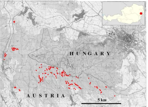
Figure 1. The sampling sites in the investigated area
110 RESULTS
List of species
In total 141 species were found, out of these were 120 bryophytes and 21 liverworts.
Hepaticeae
Blasia pusilla L. – LC – 79, 80: on soil
Calypogeia fissa (L.) Raddi – LC – 101: on soil
Cephalozia bicuspidata (L.) Dumort. – LC – 98, 101: on soil
Cephaloziella divaricata (Sm.) Schiffn. – LC – 7, 38, 62, 66, 63, 90:
on soil
Conocephalum conicum (L.) Dumort. – LC – 46: on soil
Fossombronia wondraczekii (Corda) Lindb. – NT – 79: on soil Frullania dilatata (L.) Dumort. – LC – 13: bark of Fagus sylvatica;
86: bark of Malus sylvestris
Jungermannia gracillima Sm. – LC – 63, 66: on soil
Lophocolea bidentata (L.) Dumort. – LC – 75, 67, 84: on soil
Lophocolea heterophylla (Schrad.) Dumort. – LC – 14: root of Alnus glutinosa; 16: on bark; 15, 78: on decayed wood; 90: on soil; 108:
on rooted Picea abies trunk
Lophocolea minor Nees – LC – 33: on soil
Metzgeria furcata (L.) Dumort. – LC – 108: on bark of Tilia; 119: on bark of Fagus sylvatica
Nowellia curvifolia (Dicks.) Mitt. – LC – 108: on rooted Picea abies trunk
Pellia endiviifolia (Dicks.) Dumort. – LC – 4, 79: on soil Pellia neesiana (Gottsche) Limpr. – LC – 30: on soil
Plagiochila asplenoides (L. emend. Taylor) Dumort. – LC – 46, 108:
on soil
Plagiochila porelloides (Torr. ex Nees) Lindenb. – LC – 70, 84: on soil
Ptilidium pulcherrimum (Weber) Vain. – LC – 90: on soil; 91: bark of Quercus petraea
Radula complanata (L.) Dumort. – LC – 19: bark of Acer campestre;
46: bark of Acer pseudoplatanus and Alnus glutinosa; 78: bark of Corylus avellana; 119: bark of Fagus sylvatica
Riccardia palmata (Hedw.) Carruth. – VU – 108: on rooted Picea abies trunk
Scapania nemorea (L.) Grolle – LC – 101: on soil
111 Musci
Abietinella abietina (L. ex Hedw.) M.Fleisch. var. abietina – LC – 87:
on soil
Amblystegium riparium (L. ex Hedw.) Schimp. – LC – 16: on bark and root; 77: on piece of wood
Amblystegium serpens (L. ex Hedw.) Schimp. – LC – 19: bark of Acer campestre; 21, 71: on concrete; 74: bark of Alnus glutinosa, bark of Sambucus nigra; 78: bark of Corylus avellana
Anomodon attenuatus (Hedw.) Huebener – LC – 116: on limestone Anomodon viticulosus (Hedw.) Hook. & Taylor – LC – 116: on
limestone
Atrichum undulatum (Hedw.) P.Beauv. – LC – 2, 3, 8, 10, 12, 14, 62, 63, 90: on soil
Barbula convoluta Hedw. – LC – 5: on soil
Barbula unguiculata Hedw. – LC – 44, 77, 89: on soil Bartramia pomiformis Hedw. – LC – 108: on soil
Brachytheciastrum velutinum (L. ex Hedw.) Ignatov & Huttunen – LC – 1, 14, 16: on decayed wood and soil; 7, 33, 46: on soil; 74:
bark of Alnus glutinosa
Brachythecium albicans (Neck. ex Hedw.) Schimp. – LC – 39, 42, 87:
on soil
Brachythecium glaerosum (Bruch ex Spruce) Schimp. var.
glareosum – LC – 3, 10, 11, 87: on soil
Brachythecium mildeanum (Schimp.) Schimp. – EN – 109: on soil Brachythecium rivulare Schimp. – LC – 16: on root; 50: stump of
Alnus glutinosa; 75, 76, 89: on soil; 78, 106: on decayed wood Brachythecium rutabulum (L. ex Hedw.) Schimp. – LC – 16: on
bark; 78: on decayed trunk, on concrete; 4, 39, 42, 77: on soil; 83:
on decayed wood
Brachythecium salebrosum (Hoffm. ex F.Weber & D.Mohr) Schimp.
– LC – 7: on soil; 14, 74: bark of Alnus glutinosa, bark of Sambucus nigra
Bryum argenteum Hedw. – LC – 116: on soil Bryum capillare Hedw. – LC – 104: on soil
Bryum elegans Nees var. elegans – LC – 73: on soil
Bryum moravicum Podp. – LC – 47: bark of Fraxinus sp.; 119: bark of Fagus sylvatica
Bryum rubens Mitt. – LC – 62: on soil
112
Calliergonella cuspidata (L. ex Hedw.) Loeske – LC – 3, 20, 55, 56, 63, 75: on soil; 71: on plastic foil; 78: on concrete, on decayed wood
Campylopus pyriformis (Schultz) Brid. – VU – 53: on soil
Ceratodon purpureus (Hedw.) Brid. – LC – 2, 6, 7, 10, 11, 13, 39, 42, 48, 60, 62, 87, 90: on soil
Cirriphyllum crassinervium (Taylor) Loeske & M.Fleisch. – LC – 116: on limestone
Cirriphyllum piliferum (Schreb. ex Hedw.) Grout – LC – 18, 39, 42, 48, 63, 77: on soil
Climacium dendroides (Hedw.) F.Weber & D.Mohr – LC – 18: on soil Cratoneuron filicinum (L. ex Hedw.) Spruce – LC – 37, 50, 56, 77,
78: on soil
Dicranella heteromalla (Hedw.) Schimp. – LC – 2, 7, 10, 12, 13, 62, 63, 68, 79, 90: on soil
Dicranella staphylina H.Whitehouse – LC – 39: on soil Dicranella varia (Hedw.) Schimp. – LC – 77: on soil
Dicranum montanum Hedw. – LC – 10, 12, 15: on decayed wood;
81: on decayed log; 91: bark of Quercus petraea; 91: on soil Dicranum polysetum Sw. ex anon. – LC – 62: on soil
Dicranum scoparium Hedw. – LC – 6: on decayed wood; 13, 38, 42, 90, 91: on soil; 82: stump of Alnus glutinosa
Didymodon cordatus Jur. – NT – 111: on soil; 115: surface of calcareous building; 116: on limestone
Didymodon rigidulus Hedw. – LC – 115: surface of calcareous building; 116: on limestone
Didymodon vinealis (Brid.) R.H.Zander – EN – 115: surface of calcareous building
Drepanocladus aduncus (Hedw.) Warnst. – LC – 77: on soil Encalypta streptocarpa Hedw. – LC – 116: on limestone
Eurhynchiastrum pulchellum (Hedw.) Ignatov & Huttunen var.
pulchellum – LC – 70: on soil
Eurhynchium angustirete (Broth.) T.J.Kop. – LC – 14: decayed wood; 39, 42, 63, 67, 68, 73, 84, 91: on soil
Fissidens adianthoides Hedw. – NT – 57: on soil Fissidens bryoides Hedw. – LC – 73: on soil
Fissidens taxifolius Hedw. subsp. taxifolius – LC – 1: on soil Funaria hygromertica Hedw. – LC – 62, 120: on soil
Grimmia pulvinata (Timm. ex Hedw.) Sm. – LC – 71: on concrete
Herzogiella seligeri (Brid.) Z.Iwats. – LC – 6, 15: on decayed wood
113
Heterocladium heteropterum (Brid.) Schimp. – LC – 43: on soil Homalia trichomanoides (Hedw.) Brid. – LC – 49: on root Homalothecium lutescens (Hedw.) H.Rob. – LC – 3: on soil
Homalothecium philippeanum (Spruce) Schimp. – LC – 47: bark of Fraxinus sp.; 116: on limestone
Homomallium incurvatum (Schrad. ex Brid.) Loeske – LC – 21: on concrete; 116: on limestone
Hylocomnium splendens (Hedw.) Schimp. – LC – 18, 91: on soil Hypnum cupressiforme Hedw. var. cupressiforme – LC – 1: on
decayed wood and soil; 14: root of Alnus glutinosa; 47: bark of Fraxinus; 78: bark of Alnus glutinosa; 8, 38, 84, 90, 91: on soil; 90:
bark of Malus sylvestris
Hypnum cupressiforme var. lacunosum Brid. – LC – 73: on soil Hypnum lindbergii Mitt. – LC – 71: on plastic foil; 78: on decayed
wood, 4, 39, 48, 84: on soil
Isothecium alopecuroides (Lam. ex Dubois) Isov. – LC – 119: root swelling of Fagus sylvatica
Leskea polycarpa Ehrh. ex Hedw. – LC – 19: bark of Acer campestre Leucobryum glaucum (Hedw.) Ångstr. – LC – 91: on soil
Leucobryum juniperoideum (Brid.) Müll.Hal. – LC – 90, 91: on soil Leucodon sciuroides (Hedw.) Schwägr. – LC – 86: bark of Malus
sylvestris
Microbryum davallianum (Sm.) R.H.Zander – EN – 44: on soil Mnium hornum Hedw. – LC – 108: root swelling of Tilia sp.
Mnium marginatum (Dicks.) P.Beauv. – LC – 115: surface of calcareous building
Orthotrichum affine Schrad. ex Brid. – LC – 28: bark of Fraxinus sp.
Orthotrichum anomalum Hedw. – LC – 21: on concrete; 116: on limestone
Orthotrichum cupulatum Hoffm. ex Brid. var. cupulatum – LC – 116: on limestone
Orthotrichum diaphanum Schrad. ex Brid. – LC – 65: bark of Sambucus nigra
Orthotrichum lyellii Hook. & Taylor – LC – 28: on bark of Fraxinus sp.
Orthotrichum obtusifolium Brid. – LC – 25: on bark of Fraxinus sp.
Orthotrichum pallens Bruch ex Brid. – LC – 35: bark of Fagus sylvatica
Orthotrichum speciosum Nees – LC – 35: bark of Fagus sylvatica
114
Oxyrrhynchium hians (Hedw.) Loeske var. hians – LC – 82: root swelling of Alnus glutinosa; 89: on soil
Palustriella commutata (Hedw.) Ochyra var. commutata – LC – 57, 109: on soil; 71: on plastic foil
Phascum cuspidatum Schreb. ex Hedw. var. cuspidatum – LC – 44, 45: on soil
Physcomitrium pyriforme (Hedw.) Bruch & Schimp. – LC – 60: on soil
Plagiomnium affine (Blandow ex Funck) T.J.Kop. – LC – 78: on decayed trunk; 18, 73, 90: on soil
Plagiomnium cuspidatum (Hedw.) T.J.Kop. – LC – 16: on root; 18:
on soil; 78: on concrete
Plagiomnium elatum (Bruch & Schimp.) T.J.Kop. – VU – 68: on soil Plagiomnium rostratum (Schrad.) T.J.Kop – LC – 106: on decayed
wood
Plagiomnium undulatum (Hedw.) T.J.Kop. – LC – 21, 68, 75, 78: on soil; 15: on decayed wood; 82: stump of Alnus glutinosa
Plagiothecium cavifolium (Brid.) Z.Iwats. – LC – 12, 63: on soil Plagiothecium denticulatum (L. ex Hedw.) Schimp. – LC – 12: on
soil; 15: on decayed wood
Plagiothecium laetum Schimp. var. laetum – LC – 12, 13, 16: on soil Plagiothecium nemorale (Mitt.) A.Jaeger – LC – 12: on soil
Plagiothecium succulentum (Wilson) Lindb. – LC – 16, 63: on soil Platygyrium repens (Brid.) Schimp. – LC – 78: bark of Alnus
glutinosa
Pleuridium acuminatum Lindb. – VU – 2, 62: on soil
Pleuridium subulatum (Hedw.) Rabenh. – NT – 5, 63: on soil Pleurozium schreberi (Willd. ex Brid.) Mitt. – LC – 18, 39, 42, 62, 84:
on soil
Pogonatum aloides (Hedw.) P.Beauv. – LC – 62, 63: on soil Pohlia elongata Hedw. var. elongata – LC – 12: on soil Pohlia melanodon (Brid.) A.J.Shaw – LC – 1, 89: on soil
Pohlia nutans (Hedw.) Lindb. subsp. nutans – LC – 2, 6, 63, 90: on soil
Pohlia proligera (Kindb.) Lindb. ex Broth. – VU-R – 54: on soil Pohlia wahlenbergii (F.Weber & D.Mohr) A.L.Andrews var.
wahlenbergii – LC – 5: on soil
Polytrichum formosum Hedw. – LC – 2, 6, 11, 13, 90: on soil
Polytrichum juniperinum Willd. ex Hedw. – LC – 48, 79, 90: on soil
115
Polytrichum piliferum Schreb. ex Hedw. – LC – 8, 62, 70, 90, 111: on soil
Pottia intermedia (Turner) Fürnr. – VU – 39: on soil Pottia truncata (Hedw.) Bruch & Schimp. – LC – 35: on soil Pseudephemerum nitidum (Hedw.) Loeske – EN – 98: on soil Pseudoleskeella nervosa (Brid.) Nyholm – LC – 19: bark of Acer
campestre
Pseudoscleropodium purum (L. ex Hedw.) M.Fleisch. – LC – 39, 42, 84, 90, 114: on soil
Pterigynandrum filiforme Hedw. var. filiforme – LC – 119: on bark of Fagus sylvatica
Pylaisia polyantha (Hedw.) Schimp. – LC – 19: bark of Acer campestre; 74: bark of Sambucus nigra; 78: bark of Corylus avellana
Racomitrium canescens (Timm. ex Hedw.) Brid. subsp. canescens – LC – 89: on soil
Rhizomnium punctatum (Hedw.) T.J.Kop. – LC – 16: on root and bark; 74: bark of Alnus glutinosa; 15, 83: on decayed wood; 46, 50, 82: stump of Alnus glutinosa
Rhyncostegium murale ((Neck. ex Hedw.) Schimp. – LC – 21: on concrete; 115: on calcareous building
Rhytidiadelphus squarrosus (L. ex Hedw.) Warnst. – LC – 18, 42, 84: on soil
Schistidium crassipilum H.H.Blom – LC – 21, 71: on concrete Syntrichia ruralis (Hedw.) F.Weber & D.Mohr – LC – 86: on concrete Tetraphis pellucida Hedw. – LC – 16, 106, 113: on decayed wood Thuidium assimile (Mitt.) A.Jaeger – LC – 39: on soil; 78: on decayed
wood
Thuidium delicatulum (Hedw.) Schimp. – LC – 18, 38, 84: on soil Thuidium tamariscinum (Hedw.) Schimp. – LC – 18, 78: on decayed
wood; 42, 68: on soil
Trichodon cylindricus (Hedw.) Schimp. – LC – 1, 17: on soil Tortula muralis Hedw. var. muralis – LC – 71: on concrete
Ulota bruchii Hornsch. ex Brid. – LC – 25, 110: bark of Fraxinus sp.
Ulota crispa (Hedw.) Brid. – LC – 17: bark of Betula pendula
116 DISCUSSION
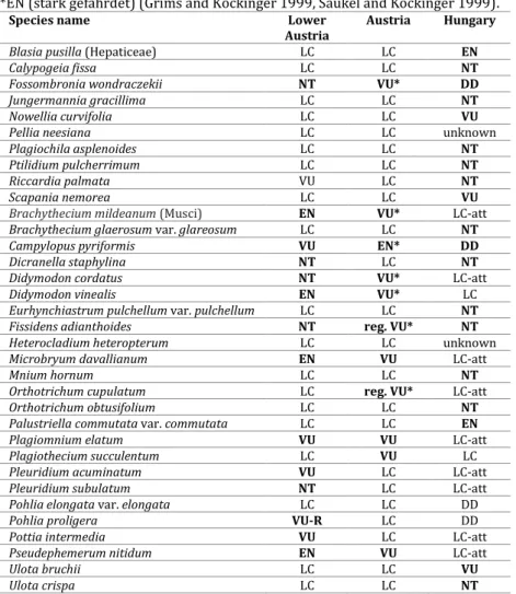
On the basis of these results, the bryophyte list of the project area was compared to the national (Grims and Köckinger 1999, Saukel and Köckinger 1999) and regional bryophyte Red Data List (Zechmeister et al. 2013) as well as to the Hungarian Red data List (Papp et al. 2010) (Table 1).
Table 1. The Red Data List status of bryophytes in Lower Austria (Niederösterreichs) (Zechmeister et al. 2013), Austria (Grims and Köckinger 1999, Saukel and Köckinger 1999) and Hungary (Papp et al. 2010).
Comments: Red Data List status in Austria:*VU (gefährdet), *reg. VU (r3 gefährdet,
*EN (stark gefährdet) (Grims and Köckinger 1999, Saukel and Köckinger 1999).
Species name Lower
Austria Austria Hungary
Blasia pusilla (Hepaticeae) LC LC EN
Calypogeia fissa LC LC NT
Fossombronia wondraczekii NT VU* DD
Jungermannia gracillima LC LC NT
Nowellia curvifolia LC LC VU
Pellia neesiana LC LC unknown
Plagiochila asplenoides LC LC NT
Ptilidium pulcherrimum LC LC NT
Riccardia palmata VU LC NT
Scapania nemorea LC LC VU
Brachythecium mildeanum (Musci) EN VU* LC-att
Brachythecium glaerosum var. glareosum LC LC NT
Campylopus pyriformis VU EN* DD
Dicranella staphylina NT LC NT
Didymodon cordatus NT VU* LC-att
Didymodon vinealis EN VU* LC
Eurhynchiastrum pulchellum var. pulchellum LC LC NT
Fissidens adianthoides NT reg. VU* NT
Heterocladium heteropterum LC LC unknown
Microbryum davallianum EN VU LC-att
Mnium hornum LC LC NT
Orthotrichum cupulatum LC reg. VU* LC-att
Orthotrichum obtusifolium LC LC NT
Palustriella commutata var. commutata LC LC EN
Plagiomnium elatum VU VU LC-att
Plagiothecium succulentum LC VU LC
Pleuridium acuminatum VU LC LC-att
Pleuridium subulatum NT LC LC-att
Pohlia elongata var. elongata LC LC DD
Pohlia proligera VU-R LC DD
Pottia intermedia VU LC LC-att
Pseudephemerum nitidum EN VU LC-att
Ulota bruchii LC LC VU
Ulota crispa LC LC NT
117
No species of the Annex II of the FFH-directive were found in the investigated area. However, Leucobryum sp. which is part of the Annex V of the respective directive was found several times (for details see the species list and corresponding site numbers).
The bryophyte flora of the investigated area resembles that of other lowlands in northern or southern Austria and despite its position in eastern Austria it has only a very small number of species typical or widespread in the Pannonian area (e.g. Didymodon vinealis). This is due to the fact that most habitats in the Sopron Hills do not represent typical eastern Austrian habitats as natural dry grasslands or vineyards. Furthermore, most of the sites are situated at comparable higher elevation as most of the sites in the east of Austria. In addition the investigated sites represent a wide range of woods and consequence microclimate and soils are more humid than at „typical” Pannonian sites.
Related to its bedrock the flora is dominated by acidophilous species and only a very few species related to calcareous bedrock were found. The large extent of woods in the area favours a wide range of shade tolerant plants, as well as epiphytes and species restricted to dead logs. Compared to other studies in the centre of the Pannonian area of the Burgenland (e.g. Zechmeister 2005b) which is slightly north of the study area, hepatics show a comparable high number in this study, which is mainly a result of the more humid situation in the investigated area.
The number of threatened species is low in our study as the investigated sites were situated within habitats which are neither threatened by human activity and nore rare in occurrence, too.
Acknowledgement – The project was financed by the „Ernst Mach-Stipendium der AÖU der Aktion Österreich-Ungarn” and „Stipendium der AÖU für Universitätslehrer der Aktion Österreich-Ungarn” scholarships.
The article was funded by „Társadalmi Megújulás Operatív Program Kutatás, Innováció, Együttműködések – Társadalmi innováció és kutatási hálózatok együttműködésének erősítése az Eszterházy Károly Főiskola, a Bay Zoltán Alkalmazott Kutatási Nonprofit Kft. és az Agria TISZK Közhasznú Nonprofit Kft.
együttműködésével” called project (TÁMOP-4.2.1.D-15/1/KONV-2015-0013). The project was supported by the European Union and the European Social Fund co- funded.The authors are grateful to Ferenc Szmorad and Tamás Pócs for their help in literature access and interpretation.
118 REFERENCES
GRIMS, F. & KÖCKINGER, H. (1999). Rote Liste gefährdeter Laubmoose (Musci) Österreichs. In: NIKLFELD,H. (ed.), Rote Liste gefährdeter Pflanzen Österreichs.
Austria Medien Service, Wien, pp. 157–171.
KIRÁLY,G. (ed., 2004). A Soproni-hegység edényes flórája. (Die Gefäßpflanzenflora des Ödenburger Gebirges). Flora Pannonica 2(1): 7–12.
KÖCKINGER,H.,SCHRÖCK,C.,KRISIAI,R.&ZECHMEISTER,H.G. (2015). Checklist of Austrian bryophytes. http://131.130.59.133/projekte/moose/ [01.11.2015.]
LATZEL,A. (1941). Beitrag zur Kenntnis der Moose des Ostralpenrandgebiets. Beih.
Bot. Centralbl. 61: 211–260.
MAURER,W. (1965). Die Moose des Südburgenlandes. Wiss. Arb. Burgenland 32: 5–
40.
PAPP,B.,ERZBERGER,P.,ÓDOR,P.,HOCK,ZS.,SZÖVÉNYI,P.,SZURDOKI,E.&TÓTH,Z. (2010).
Updated checklist and redlist of Hungarian bryophytes. Studia botanica hungarica 41: 31–59.
SAUKEL,J.&KÖCKINGER,H. (1999). Rote Liste gefährdeter Lebermoose (Hepaticae) und Hornmoose (Anthocerotae) Österreichs. In: NIKLFELD, H. (ed.): Rote Liste gefährdeter Pflanzen Österreichs, Austria Medien Service, Wien, pp. 172–177.
SCHLÜSSLMAYR,G. (2001). Die Moosvegetation des Leithagebirges im Burgenland.
Verhandlungen der Zoologisch-Botanischen Gesellschaft in Wien 138: 65–93.
SZMORAD, F. (2010). A Soproni-hegység erdeinek történeti, növényföldrajzi és cönológiai vizsgálata. (The historical, phytogeographical and coenological investigations on the forest of the Sopron Hills). PhD dissertation in manuscript, Pécsi Tudományegyetem Biológia Doktori Iskola, Pécs. 128 pp.
SZMORAD,F. (2011). The Riparian Alder Forests of the Sopron Hills. Acta Silvatica &
Lignaria Hungarica 7: 109–124.
SZŰCS,P.&SZMORAD,F. (2009). Ergänzungen zur Moosflora des Ödenburger Gebirges.
Flora Pannonica 7: 61–72.
ZECHMEISTER,H.G. (2004). Die Moosflora im Natura 2000 Gebiet "Neusiedlersee", unter besonderer Berücksichtigung der Salzwiesen im Seewinkel.
Verhandlungen der Zoologisch-Botanischen Gesellschaft in Wien 141: 43–62.
ZECHMEISTER,H.G. (2005a). Bryophytes of continental salt meadows in Austria.
Journal of Bryology 27: 297–302.
ZECHMEISTER, H.G. (2005b). Die Moosflora der Serpentinrasen im Burgenland.
Verhandlungen der Zoologisch-Botanischen Gesellschaft in Wien 142: 9–15.
ZECHMEISTER,H.G. (2008). Vorkommen und Gefährdung der Torfmoose (Gattung Sphagnum L.) im Burgenland. Verhandlungen der Zoologisch-Botanischen Gesellschaft in Wien 145: 97–106.
ZECHMEISTER,H.G.,HAGEL,H.,GENDO,A.,OSVALDIK,V.,PATEK,M.,PRINZ,M.,SCHRÖCK,C.&
KÖCKINGER, H. (2013). Die Rote Liste der Moose Niederösterreichs.
Wissenschaftliche Mitteilungen Niederösterreichisches Landesmuseum 24: 4–
126.
(submitted: 30.11.2015, accepted: 04.01.2016)
119 APPENDIX
Site details
1. Burgenland, Bezirk Oberpullendorf, Ritzing, Angerwald, near country border, planted Picea abies forest (21.10.2009) N47°38'24.7” E16°29'43.9”, 477 m. [8364.4]
2. Burgenland, Bezirk Oberpullendorf, Ritzing, Angerwald, near country border, Fagus sylvatica forest (22.10.2009) N47°38'21.9” E16°30'4.0”, 472 m. [8365.3]
3. Burgenland, Bezirk Oberpullendorf, Ritzing, near village, on gravelly forest road (23.07.2013) N47°38'33.9” E 16°28'19.4”, 430 m. [8364.4]
4. Burgenland, Bezirk Oberpullendorf, Ritzing, near village, next to gravelly forest road (23.07.2013) N47°38'34.9” E16°28'17.0”, 433 m. [8364.4]
5. Burgenland, Bezirk Oberpullendorf, Ritzing, lake (23.07.2013) N47°38'45.5” E16°28'11.0”, 436 m. [8364.4]
6. Burgenland, Bezirk Oberpullendorf, Ritzing, on embankment of forest road (23.07.2013) N47°38'57.7” E16°28'16.7”, 478 m. [8364.4]
7. Burgenland, Bezirk Oberpullendorf, Ritzing, by forest road (23.07.2013) N47°38'57.7”
E16°28'16.7.”, 481 m. [8364.4]
8. Burgenland, Bezirk Oberpullendorf, Ritzing, in deciduous forest, by forest road (23.07.2013) N47°38'58.1” E16°27'59.0”, 525 m. [8364.4]
9. Burgenland, Bezirk Oberpullendorf, Ritzing, in deciduous forest (23.07.2013) N47°39'01.1”
E16°27'50.2”, 552 m. [8364.2]
10. Burgenland, Bezirk Oberpullendorf, Ritzing, in deciduous forest, by forest road (23.07.2013) N47°39'01.6” E16°27'37.8”, 544 m. [8364.2]
11. Burgenland, Bezirk Oberpullendorf, Ritzing, by forest road (23.07.2013) N47°39'04.2”
E16°27'37.0”, 543 m. [8364.2]
12. Burgenland, Bezirk Oberpullendorf, Ritzing, on embankment of forest road (23.07.2013) N47°39'01.2” E16°27'32.9”, 526 m. [8364.2]
13. Burgenland, Bezirk Oberpullendorf, Ritzing, in old Fagus sylvatica forest (23.07.2013) N47°38'57.7” E16°27'33.2”, 518 m. [8364.4]
14. Burgenland, Bezirk Oberpullendorf, Ritzing, near lake, by stream (23.07.2013) N47°38'55.20.0” E16°27'28.0”, 494 m. [8364.4]
15. Burgenland, Bezirk Oberpullendorf, Ritzing, by stream (23.07.2013) N47°38'52.6”
E16°27'30.9”, 482 m. [8364.4]
16. Burgenland, Bezirk Oberpullendorf, Ritzing, dried puddles (23.07.2013) N47°38'41.0”, E16°27'36.3”, 467 m. [8364.4]
17. Burgenland, Bezirk Oberpullendorf, Ritzing, by forest road (23.07.2013) N47°38'38.5”, E16°27'41.7”, 459 m. [8364.4]
18. Burgenland, Bezirk Oberpullendorf, Ritzing, grassland (23.07.2013) N47°38'30.8”, E16°27'58.2”, 415 m. [8364.4]
19. Burgenland, Bezirk Oberpullendorf, Ritzing, in deciduous forest, by the forest road (23.07.2013) N47°38'24.2”, E16°28'6.4”, 422 m. [8364.4]
20. Burgenland, Bezirk Oberpullendorf, Ritzing, grassland (23.07.2013) N47°38'17.3”
E16°28'10.6”, 393 m. [8364.4]
21. Burgenland, Bezirk Oberpullendorf, Ritzing, Waldschule, by the road (23.07.2013) N47°38'33.0” E16°28'32.4”, 416 m. [8364.4]
22. Burgenland, Bezirk Oberpullendorf, Ritzing, old Fagus sylvatica forest, by the forest road (26.10.2013) N47°38'45.8” E16°28'57.4”, 482 m. [8364.4]
23. Burgenland, Bezirk Oberpullendorf, Ritzing, old Fagus sylvatica forest (26.10.2013) N47°38'42.7” E16°28'58.6”, 491 m. [8364.4]
24. Burgenland, Bezirk Oberpullendorf, Ritzing, Lange Zeile, embankment of forest road (26.10.2013) N47°38'33.1” E16°28'59.0”, 486 m. [8364.4]
25. Burgenland, Bezirk Oberpullendorf, Ritzing, Lange Zeile, crossroads (26.10.2013) N47°38'28.0” E16°29'1.40”, 486 m.
120
26. Burgenland, Bezirk Oberpullendorf, Ritzing, border of coniferous forest (26.10.2013) N47°38'25.6” E16°28'50.0”, 481 m. [8364.4]
27. Burgenland, Bezirk Oberpullendorf, Ritzing, in coniferous forest (26.10.2013) N47°38'27.1” E16°28'41.1”, 449 m. [8364.4]
28. Burgenland, Bezirk Oberpullendorf, Ritzing, in little valley (26.10.2013) N47°38'31.2”
E16°28'44.9”, 434 m. [8364.4]
29. Burgenland, Bezirk Oberpullendorf, Ritzing, embankment of road, in wheel-tack (26.10.2013) N47°38'39.6” E16°28'45.2”, 432 m. [8364.4]
30. Burgenland, Bezirk Oberpullendorf, Ritzing, embankment of road, in wheel-tack (26.10.2013) N47°38'40.4” E16°28'46.5”, 435 m. [8364.4]
31. Burgenland, Bezirk Oberpullendorf, Ritzing, in old Fagus sylvatica forest (28.10.2013) N47°38'39.2” E16°29'5.1”, 502 m. [8364.4]
32. Burgenland, Bezirk Oberpullendorf, Ritzing, in old Fagus sylvatica forest (28.10.2013) N47°38'30.7” E16°29'12.0”, 512 m. [8364.4]
33. Burgenland, Bezirk Oberpullendorf, Ritzing, in deciduous forest, embankment of forest road (28.10.2013) N47°38'9.1” E16°29'6.8”, 486 m. [8364.4]
34. Burgenland, Bezirk Oberpullendorf, Ritzing, in deciduous forest, embankment of forest road (28.10.2013) N47°38'9.1” E16°29'6.8”, 472m. [8364.4]
35. Burgenland, Bezirk Oberpullendorf, Ritzing, border of grassland (28.10.2013) N47°37'35.7” E16°29'25.5”, 379 m. [8364.4]
36. Burgenland, Bezirk Oberpullendorf, Ritzing, grassland (28.10.2013) N47°37'33.2”
E16°29'31.0”, 370 m. [8364.4]
37. Burgenland, Bezirk Oberpullendorf, Ritzing, grassland, stream (28.10.2013) N47°37'50.4”
E16°29'27.7”, 399 m. [8364.4]
38. Burgenland, Bezirk Oberpullendorf, Ritzing, in deciduous forest, embankment of forest road (28.10.2013) N47°38'2.8” E16°29'9.8”, 471 m. [8364.4]
39. Burgenland, Bezirk Oberpullendorf, Ritzing, Pinus sylvestris forest, in glade (28.10.2013) N47°37'54.0” E16°29'30.6”, 421 m. [8364.4]
40. Burgenland, Bezirk Oberpullendorf, Ritzing, Pinus sylvestris forest, in glade (28.10.2013) N47°37'54.1” E16°29'34.6”, 444 m. [8364.4]
41. Burgenland, Bezirk Oberpullendorf, Ritzing, Pinus sylvestris forest, in glade (28.10.2013) 47°37'54.1” 16°29'34.5”, 444 m. [8364.4]
42. Burgenland, Bezirk Oberpullendorf, Ritzing, Pinus sylvestris forest, in glade (28.10.2013) N47°37'54.2” E16°29'38.2”, 456 m. [8364.4]
43. Burgenland, Bezirk Oberpullendorf, Ritzing, border of Pinus sylvestris forest, by forest road (28.10.2013) N47°37'53.0” E16°29'42.9”, 450 m. [8364.4]
44. Burgenland, Bezirk Oberpullendorf, Ritzing, arable field (28.10.2013) N47°37'33.9”
E16°29'58.2”, 398 m. [8364.4]
45. Burgenland, Bezirk Oberpullendorf, Ritzing, arable field (28.10.2013) N47°37'29.9”
E16°30'9.4”, 395 m. [8365.3]
46. Burgenland, Bezirk Oberpullendorf, Ritzing, valley, by stream (28.10.2013) N47°37'39.1”
E16°30'26.2”, 367 m. [8365.3]
47. Burgenland, Bezirk Oberpullendorf, Ritzing, valley, by stream (28.10.2013) N47°37'40.4”
E16°30'24.1”, 368 m. [8365.3]
48. Burgenland, Bezirk Oberpullendorf, Ritzing, gravelly road crossing (28.10.2013) N47°37'43.5” E16°30'22.4”, 360 m. [8365.3]
49. Burgenland, Bezirk Oberpullendorf, Ritzing, valley, by stream (28.10.2013) N47°37'44.9”
E16°30'17.4”, 371 m. [8365.3]
50. Burgenland, Bezirk Oberpullendorf, Ritzing, valley, by stream (28.10.2013) N47°37'45.5”
E16°30'12.1”, 371 m. [8365.3]
51. Burgenland, Bezirk Oberpullendorf, Ritzing, valley, by stream (28.10.2013) N47°37'47.4”
E16°30'10.4”, 378 m. [8365.3]
52. Burgenland, Bezirk Oberpullendorf, Ritzing, valley, by stream (28.10.2013) N47°37'48.5”
E16°30'08.6”, 383 m. [8365.3]
121
53. Burgenland, Bezirk Oberpullendorf, Ritzing, embankment of forest road (28.10.2013) N47°37'53.3” E16°30'08.6”, 401 m. [8365.3]
54. Burgenland, Bezirk Oberpullendorf, Ritzing, by forest road, little lake (28.10.2013) N47°38'05.8” E16°29'46.5”, 449 m. [8364.4]
55. Burgenland, Bezirk Oberpullendorf, Ritzing, wet grassland (28.10.2013) N47°37'59.0”
E16°29'20.4”, 418 m. [8364.4]
56. Burgenland, Bezirk Oberpullendorf, Ritzing, wet grassland (28.10.2013) N47°38'00.4”
E16°29'20.0”, 421 m. [8364.4]
57. Burgenland, Bezirk Oberpullendorf, Ritzing, calcareous spring (28.10.2013) N47°38'05.6”
E16°29'18.6”, 447 m. [8364.4]
58. Burgenland, Bezirk Oberpullendorf, Ritzing, by forest road (28.10.2013) N47°38'07.3”
E16°29'19.9”, 510 m. [8364.4]
59. Burgenland, Bezirk Oberpullendorf, Ritzing, Angerwald, near country border, deciduous forest (30.10.2013) N47°38'29.3” E16°29'27.1”, 521 m. [8364.4]
60. Burgenland, Bezirk Oberpullendorf, Ritzing, Angerwald, near country border, deciduous forest (30.10.2013) N47°38'31.8” E16°29'34.5”, 519 m. [8364.4]
61. Burgenland, Bezirk Oberpullendorf, Ritzing, near country border, embankment of forest road (30.10.2013) N47°38'21.3” E16°30'15.9”, 451 m. [8365.3]
62. Burgenland, Bezirk Oberpullendorf, Ritzing, Gruberkreuz, near country border, forest road crossing, little lake (30.10.2013) N47°38'16.9” E16°30'24.0”, 445 m. [8365.3]
63. Burgenland, Bezirk Oberpullendorf, Ritzing, abandoned gneis-stone quarry (30.10.2013) N47°38'35.5” E16°31'08.8”, 440 m. [8365.3]
64. Burgenland, Bezirk Oberpullendorf, Ritzing, embankment of forest road (30.10.2013) N47°38'20.1” E16°31'23.8”, 445 m. [8365.3]
65. Burgenland, Bezirk Oberpullendorf, Ritzing, by forest road (30.10.2013) N47°37'59.4”
E16°31'40.0”, 345 m. [8365.3]
66. Burgenland, Bezirk Oberpullendorf, Ritzing, embankment of forest road (30.10.2013) N47°37'58.2” E16°31'42.5”, 365 m. [8365.3]
67. Burgenland, Bezirk Oberpullendorf, Ritzing, embankment of forest road (30.10.2013) 47°37'34.6” E16°31'58.2”, 330 m. [8365.3]
68. Burgenland, Bezirk Oberpullendorf, Ritzing, by forest road (30.10.2013) N47°37'41.7”
E16°31'45.3”, 340 m. [8365.3]
69. Burgenland, Bezirk Oberpullendorf, Ritzing, abandoned quarry, recultivated places (30.10.2013) N47°37'41.7” E16°31'45.3”, 340 m. [8365.3]
70. Burgenland, Bezirk Oberpullendorf, Ritzing, embankment of forest road (30.10.2013) N47°37'30.1” E16°32'03.1”, 325 m. [8365.3]
71. Burgenland, Bezirk Oberpullendorf, Neckenmarkt, fence of garden (30.10.2013) N47°37'10.6” E16°32'27.1”, 290 m. [8365.3]
72. Burgenland, Bezirk Oberpullendorf, Neckenmarkt, weekend houses (30.10.2013) N47°37'13.1” E16°32'21.9 ”, 300 m. [8365.3]
73. Burgenland, Bezirk Mattersburg, Marz, near recultivated quarry, by forest road (22.11.2013) N47°42'16.8” E16°23'47.1”, 465 m. [8264.3]
74. Burgenland, Bezirk Mattersburg, Sieggraben, by stream (22.11.2013) N47°40'22.7”
E16°23'54.6”, 380 m. [8364.1]
75. Burgenland, Bezirk Mattersburg, Sieggraben, wet grassland (22.11.2013) N47°40'22.9”
E16°23'55.8”, 375 m. [8364.1]
76. Burgenland, Bezirk Mattersburg, Sieggraben, wet grassland (22.11.2013) N47°40'22.4”
E16°23'58.1”, 385 m. [8364.1]
77. Burgenland, Bezirk Mattersburg, Sieggraben, wetland and stream (22.11.2013) N47°40'21.9” E16°24'02.3”, 380 m. [8364.1]
78. Burgenland, Bezirk Mattersburg, Sieggraben, wetland and stream (22.11.2013) N47°40'20.7” E16°24'06.1”, 385 m. [8364.1]
79. Burgenland, Bezirk Mattersburg, Sieggraben, embankment of forest (22.11.2013) N47°40'18.6” E16°24'03.6”, 400 m. [8364.1]
122
80. Burgenland, Bezirk Mattersburg, Sieggraben, by forest road, little pond (22.11.2013) N47°40'18.8” E16°23'59.5”, 395 m. [8364.1]
81. Burgenland, Bezirk Mattersburg, Sieggraben, near forest road (22.11.2013) N47°40'18.6”
E16°24'03.6”, 395 m. [8364.1]
82. Burgenland, Bezirk Mattersburg, Sieggraben, valley, by stream (22.11.2013) N47°39'36.5”
E16°22'53.1”, 500 m. [8364.1]
83. Burgenland, Bezirk Mattersburg, Sieggraben, Satterhöhe, valley, by stream (22.11.2013) N47°39'43.5” E16°22'49.3”, 470 m. [8364.1]
84. Burgenland, Bezirk Mattersburg, Sieggraben, border of grassland, embankment of forest road (22.11.2013) N47°39'46.7” E16°22'53.2”, 455 m. [8364.1]
85. Burgenland, Bezirk Mattersburg, Sieggraben, valley, by sream (22.11.2013) N47°39'40.6”
E16°22'52.9”, 475 m. [8364.1]
86. Burgenland, Bezirk Mattersburg, Sieggraben, roadside (22.11.2013) N47°39'34.0”
E16°22'45.1”, 495 m. [8364.1]
87. Burgenland, Bezirk Mattersburg, Kalkgraben, grassland and roadside (22.11.2013) N47°39'40.6” E16°22'52.9”, 455 m. [8364.1]
88. Burgenland, Bezirk Mattersburg, Kalkgraben, grassland (22.11.2013) N47°39'40.6”
E16°22'52.9”, 420 m. [8364.1]
89. Burgenland, Bezirk Oberpullendorf, Neckenmarkt, Millenium Teich, between two lakes (24.06.2014) N47°36’59.1” E16°34’05.0”, 235 m. [8365.3]
90. Burgenland, Bezirk Oberpullendorf, Neckenmarkt, embankment of forest road (24.06.2014) N47°37’33.2” E16°33’30.7”, 335 m. [8365.3]
91. Burgenland, Bezirk Oberpullendorf, Neckenmarkt, near embankment of forest road, deciduous forest (24.06.2014) N47°37’33.8” E16°33’27.4”, 350 m. [8365.3]
92. Burgenland, Bezirk Oberpullendorf, Ritzing, in glade, grass, on soil (30.07.2014) N47°39’07.6” E16°27’20.4”, 545 m. [8364.2]
93. Burgenland, Bezirk Oberpullendorf, Ritzing, in mixed forest (30.07.2014) N47°38’54.2”
E16°27’03.6”, 565 m. [8364.4]
94. Burgenland, Bezirk Oberpullendorf, Ritzing, in mixed forest (30.07.2014) N47°38’46.5”
E16°26’56.4”, 545 m. [8364.4]
95. Burgenland, Bezirk Oberpullendorf, Ritzing, in glade of planted pine forest, grass (30.07.2014) N47°38’20.1” E16°26’43.2”, 440 m. [8364.4]
96. Burgenland, Bezirk Oberpullendorf, Ritzing, next of planted pine forest, by forest road (30.07.2014) N47°38’15.5” E16°26’46.8”, 420 m. [8364.4]
97. Burgenland, Bezirk Oberpullendorf, Ritzing, by forest road (30.07.2014) N47°38’10.2”
E16°26’41.7”, 405 m. [8364.4]
98. Burgenland, Bezirk Oberpullendorf, Ritzing, wall of road cut (30.07.2014) N47°38’07.9”
E16°26’43.7”, 420 m. [8364.4]
99. Burgenland, Bezirk Oberpullendorf, Ritzing, in coniferous forest (30.07.2014) N47°38’07.2” E16°26’45.0”, 445 m. [8364.4]
100. Burgenland, Bezirk Oberpullendorf, Ritzing, in coniferous forest (30.07.2014) N47°38’07.9” E16°26’42.8”, 445 m. [8364.4]
101. Burgenland, Bezirk Oberpullendorf, Ritzing, on embankment of forest road (30.07.2014) N47°38’06.8” E16°26’36.9”, 410 m. [8364.4]
102. Burgenland, Bezirk Oberpullendorf, Ritzing, by forest road (30.07.2014) N47°38’06.1”
E16°26’35.4”, 410 m. [8364.4]
103. Burgenland, Bezirk Oberpullendorf, Ritzing, on embankment of road (30.07.2014) N47°38’05.2” E16°26’35.3”, 410 m. [8364.4]
104. Burgenland, Bezirk Oberpullendorf, Ritzing, by forest road (30.07.2014) N47°38’08.8”
E16°26’33.6”, 395 m. [8364.4]
105. Burgenland, Bezirk Oberpullendorf, Ritzing, embankment of forest road (30.07.2014) N47°38’10.1” E16°26’33.2”, 405 m. [8364.4]
106. Burgenland, Bezirk Oberpullendorf, Ritzing, in Alnus glutinosa marsh (30.07.2014) N47°38’09.9” E16°26’31.8”, 400 m. [8364.4]
123
107. Burgenland, Bezirk Oberpullendorf, Ritzing, by stream, water conversancy building (30.07.2014) N47°38’09.3” E16°26’29.8”, 400 m. [8364.4]
108. Burgenland, Bezirk Oberpullendorf, Ritzing, by stream (30.07.2014) N47°38’10.3”
E16°26’29.3”, 400 m. [8364.4]
109. Burgenland, Bezirk Oberpullendorf, Ritzing, in Alnus glutinosa marsh (30.07.2014) N47°38’10.8” E16°26’30.9”, 405 m. [8364.4]
110. Burgenland, Bezirk Oberpullendorf, Ritzing, by stream (30.07.2014) N47°38’11.6”
E16°26’26.8”, 400 m. [8364.4]
111. Burgenland, Bezirk Oberpullendorf, Ritzing, by forest road (31.07.2014) N47°39’14.7”
E16°26’38.9”, 495 m. [8364.2]
112. Burgenland, Bezirk Oberpullendorf, Ritzing, by forest road (31.07.2014) N47°39’04.7”
E16°26’38.1”, 480 m. [8364.2]
113. Burgenland, Bezirk Oberpullendorf, Ritzing, by wet places (31.07.2014) N47°39'1.6”
E16°26'26.6”, 465 m. [8364.2]
114. Burgenland, Bezirk Oberpullendorf, Ritzing, near planted Picea abies forest, by forest road (31.07.2014) N47°38'49.9” E16°26'04.1”, 460 m. [8364.4]
115. Burgenland, Bezirk Oberpullendorf, Ritzing, by stream, on milestone (31.07.2014) N47°38'12.5” E16°26'25.6”, 405 m. [8364.4]
116. Burgenland, Bezirk Oberpullendorf, Ritzing, by road-crossing, monument (31.07.2014) N47°37'57.6” E16°26'21.3”, 385 m. [8364.4]
117. Burgenland, Bezirk Oberpullendorf, Ritzing, in deciduous forest, coulloir (31.07.2014) N47°38'41.2” E16°27'7.3”, 525 m. [8364.4]
118. Burgenland, Bezirk Oberpullendorf, Ritzing, in deciduous forest, (31.07.2014) N47°38'40.1” E16°27'4.8”, 515 m. [8364.4]
119. Burgenland, Bezirk Oberpullendorf, Ritzing, in deciduous forest, by forest road (31.07.2014) N47°38'39.9” E16°26'49.6”, 530 m. [8364.4]
120. Burgenland, Bezirk Oberpullendorf, Ritzing, in road-crossing (31.07.2014) N47°39'03.4”
E16°27'5.9”, 540 m. [8364.2]