JUDIT BÁRCZINÉ KAPOVITS
ESTABLISHMENT OF THE LANDSCAPE ARCHITECTURAL METHODOLOGY FOR GREENWAY PLANNING IN HUNGARY
PhD BOOK OF THESES
BUDAPEST, 2014
Name of
Doctoral school: Corvinus University of Budapest
Landscape Architecture and Landscape Ecology Field: Agricultural Technology
Head of
Doctoral School: Prof. Attila Csemez, DSc
Corvinus University of Budapest Faculty of Landscape Architecture Department of Landscape Planning and Regional Development
Supervisor: Prof. Attila Csemez, DSc
Corvinus University of Budapest Faculty of Landscape Architecture Department of Landscape Planning and Regional Development
Associate supervisor: Ágnes Sallay, PhD
Corvinus University of Budapest Faculty of Landscape Architecture Department of Landscape Planning and Regional Development
The applicant met the requirement of the PhD regulations of the Corvinus University of Budapest and the theses are accepted for defence process.
.……….... ………...
Head of Doctoral School Supervisor
I. Aim of the research
The aim of my research is the establishment of planning for new outdoor recreation alternatives in Hungary using Olmsted’s greenway model, so that the proposed greenway planning methodology integrates into Hungary’s specific landscape conditions and into the spatial and settlement planning system which forms part of the legislative system. My priority aim is expression of a definition of greenways, containing their crucial spatial characteristics, clearly expressing meaning, and capable of integration into the legal and technical environment; this is in order that the concept of greenway can appear in specialist literature and in planning processes aimed at practical implementation. I have paid particular attention to the best possible integration of the results of regional civil society greenway programmes into landscape planning and into the hierarchical order of spatial and settlement planning.
II. Materials and methods
My research methods are based on the general methodology of scientific research, which is complemented by research methods peculiar to landscape architecture. The academic approach is based on exploration of literature on greenway design. I first analysed the landscape architecture study which can be regarded as the introduction to Hungary of greenway design (CSEMEZ et al, 2000) and then I reviewed the Hungarian academic publications on the topic. The sources found in the literature were primary and secondary sources, and their content derived from design historical, scientific and civil society organisations. I evaluated the meaning of the greenway concepts mentioned in the specialist literature and in the civil society initiated greenway programmes, I examined the semantic similarities and differences in concepts used in spatial and settlement planning, and in scientific wording used in ecological studies. An important part of the research was analysis based on findings gained from multiple site visits in the study area.
Among the acknowledged foreign sources, I paid special attention to analysis of overviews in landscape architecture-themed publications (FABOS, 1995; SEARNS, 1995; ZUBEK, 1995;
BISCHOFF, 1995). In reviewing the major specialist literature on greenway planning, I see the development and practice of US greenway planning as the model, and examine the possibility of its application in Hungary. The reason for this is that the source for all other landscape architecture- based greenway planning – European and Asian – is US greenway planning based on the concept of an Olmsted-style green space system. Based on the demonstrably workable Olmsted greenway model, greenway concepts and methodological planning variations have emerged in other continents and countries, adapted to local landscape characteristics. I also think it important to use the original landscape architecture source as a model, because in the activities of civil society-
initiated greenway movements, the focus is on local initiatives, and the strengthening of local communities related to this. At the same time, because of the tourist potential of greenways, the regionally relevant characteristics and expected effects of greenways are important, and these need to be revealed through landscape design incorporated into the spatial and settlement planning system.
The material examined during research:
— the Olmsted greenway model and its development in specialist literature
— the research and teaching results so far on Hungarian greenway design
— the results of civil society greenway movements
— the landscape features of the chosen study area
— the national spatial planning system
— the national settlement planning system The research methods used:
— analysis of greenway planning literature
— landscape architecture analysis of the study area in terms of the use of the greenway model
— multiple personal site visits to the study area and analysis of findings
— meetings with affected landowners and farmers in the study area
— specialist meetings
— the generalisation and extension of the results of the tests on the sample area
— coordination with the research topic of findings from participation in conferences Proposition 1:
Exploration of the historical precedents of Greenway Design in Hungary
I explored the historical precedents of greenway planning in Hungary in the light of examples from literature in landscape architecture. I found that the following are historical precedents of Hungarian greenway design, and that these can be incorporated into a functioning greenways network: the planning and design of Hungarian urban parkways; the creation of bridle paths in Baroque mansion grounds; the planning of pedestrian tourist trails; and in particular the planning of cycle routes and pedestrian/ cycle routes in natural and semi-natural environments.
Emblematic examples of the history of greenway design in Hungary
— Andrássy út in Budapest
— the Danube Promenade Budapest
— bridle paths in the grounds of Baroque mansions
— tourist route network in Hungary
— pilgrimage routes
— EuroVelo 6 cycle route alongside the Danube
— EuroVelo 11 cycle route alongside the Tisza
— cycle route around Lake Balaton
— cycle route around Lake Fertő / Neusiedl
— cycle route around Lake Velence
— EuroVelo 13 cycle and walking route along the former Iron Curtain
— the cycle and walking route and green space development alongside the Séd Stream
— the cycle and walking route and green space development alongside the Rákos Stream
— the cycle and walking route and green space development alongside the Szilas Stream
— the cycle route alongside the Általér
— greenways initiated by civil society organisations Application to study area
The historical precursor to greenway design in the Zsámbék Basin was the civil society greenway network proposed by the Budavidék Greenway Alliance (Figure 1).
Proposition 2:
The creation of a definition of “greenway” which can be integrated into Hungarian spatial and settlement planning
I reviewed the major definitions of greenways in landscape architecture literature and – with reference to landscape architecture research and examples realised in practice – highlighted the specific spatial characteristics of the greenway model based on Frederick Law Olmsted’s design concept. I presented the opportunity and innovative nature of greenway design in the study area of the Zsámbék Basin, and taking the Hungarian legal context into consideration arrived at a definition of “greenway” which can be integrated within the spatial and settlement planning system.
My proposed definition: A greenway is a route designed for more than one type of recreational use, which, together with linked green spaces, creates a regional-level, hierarchical network. The main areas for the establishment of greenways are alongside watercourses, abandoned railway lines, historical trails, traditional routes between settlements preserved as agricultural tracks, and other particular linear landscape elements which are suitable for playing both recreational and ecological roles.
Application to study area
The innovative feature of the greenway network proposed for the Zsámbék Basin area is planned dual use of the routes by pedestrians and cyclists; the spine of the network is the Békás Stream and
the traditional trail between the settlements of Budajenő and Páty. The proposed greenway network is an alternative to the cycle routes alongside the main road proposed in regional and local plans, and it complements the existing network of hiking trails (Figures 2, 4, 5 and 6).
Proposition 3:
Determination of the basic spatial possibilities of Hungarian greenways
I explored the similar or different roles of greenways and single-use recreational routes (walking or cycling routes), greenways and ecological corridors, as well as the spatial design possibilities. I found that, according to the defining characteristics of the greenway model, there are existing multi- purpose recreational trails in Hungary which can be considered to be greenways. These can form part of a greenway network without the need for further action or improvements. I established that some walking and cycling routes can be converted to greenways through the addition of recreational uses and green space/ ecological development. I also found that some ecological corridors could become greenways through the recreational development of green space. Within the study area I showed that greenways can be designed as new landscape elements with the harmonisation of recreationally and ecologically oriented developments.
The basic spatial possibilities of establishing greenways in Hungary:
— existing or planned multi-purpose recreational routes with ecological roles being connected as greenways to the greenway network
— development of existing or planned single-use recreational routes as greenways through green space/ ecological design
— formation of existing or planned ecological and recreational green corridors as greenways through design of recreational use
— planning of new greenways by using the greenway model Application to study area
The following are the spatial possibilities of the greenway network proposed by me for the Zsámbék Basin:
— the traditional trail with double row of trees connecting the settlements of Budajenő and Páty identified for pedestrian and cycle use at the initiative of the Budavidék Greenway Alliance
— the ecological corridor along the Békás and Budajenő streams and the sections of green corridor alongside the abandoned Biatorbágy railway line which can be developed with the planning of recreational uses
— new greenway sections alongside tributaries of the Békás Stream and some agricultural tracks
Proposition 4:
Determination of greenway planning tasks through the classification of greenways in Hungary I found that the classification of greenways is necessary for the determination of greenway planning tasks related to given planning areas. I identified the main types of greenway through determining their location and spatial roles. In my proposal for classification I defined the general, common tasks, as well as specific design tasks for each greenway type. In the process of designing greenways the defined tasks should be developed together by type according to the two aspects. I present greenway types appearing within a specific greenway network, the regional-level greenway network concept that I propose for the Zsámbék Basin area.
The
classification system
1. Greenway types according to location:
- waterside greenways
- greenways alongside abandoned railway lines - greenways on historical routes
- greenways on traditional routes between settlements - greenways within settlements
- other greenways
2. Greenway types according to regional role:
- nationwide greenways - regional greenways - local greenways Application to study area
The elements of regional significance of my proposed greenway network for the Zsámbék Basin area are: waterside sections alongside the Békás and Füzes streams which can be classified as greenways; sections which can be classified as greenways on the traditional route between Budajenő and Páty; and some sections which can be classified as greenways within the settlements of Budajenő, Páty and Biatorbágy. The greenway sections of regional importance alongside the Békás Stream can be connected to the cycle route alongside the Danube, which can become a greenway of national significance. Among the proposed greenway sections of local status are those which can be classified as greenways running alongside abandoned railway tracks, greenways within settlements and other greenway types (Figure 3).
Figure 1:: Civil society greenway network in Zsambek Basin
Figure 2: The proposed greenway network applied on the greenway model by the author
Figure 3: The proposed greenway types on zhe example of the Zsambek
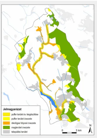
Figure 7: The proposed demarkation of a regional zone suitable for greenway development on the example of the Zsambek Basin
Figure 8: The overlapping "Regional zone alongside ecological corridor' and the proposed 'Regional zone for greenway development' on the example of the Zsambek Basin
Figure 5: A cycle route section in the regional plan alongside a main road versus a greenway section alternatíve alongside a traditional trail versus train for regional cycle route
Figure 6: Waterside greenway opportunity alongside Bekas Stream versus cycle route opportunity alongside a planned main road Figure 4: A greenway section
signed alongside agricultural tracks versus a proposed waterside greenway section alongside the Bekas Stream
Proposition 5:
Determination of the place of greenway planning within spatial planning in Hungary
I determined the potential for integration of greenway planning work into planning processes at national, county and highlighted regional levels, on the basis of the requirements of Government Decree 218/2009 (X.6.), which defines regulations for the content of spatial plans.
I found that greenway planning can be incorporated into the Examination and Programme stages of spatial plans and into procedures for regional impact assessments and environmental impact assessments. Regional-level greenways can appear in regional zone plans as proposed regional zones for the formation of greenways. The formation of zones ensures the emergence of greenway networks forming an interrelated, hierarchical system. I found that greenway design can appear as an independent phase of work among underlying work stages, thus contributing to the further detailed planning of defined greenways at national and regional levels, in the course of settlement planning.
Application to study area
According to the work phases in Government Decree 218/2009 (X.6.), the integration of the proposed regional-level greenway network for the area of the Zsámbék Basin can be incorporated into the spatial planning process, into the Spatial Plan of the Budapest Agglomeration as a priority area, or into the Pest County Spatial Plan.
Proposition 6:
Establishing the formation of a “proposed regional zone for greenway development”
I found that in terms of land use greenways are unvarying, but with regard to treatment and usage patterns they can be seen as areas requiring different treatment, so that the demarcation of an independent regional zone can provide for their optimal design, development and maintenance.
The aim of the formation of a “proposed regional zone for greenway development”:
The primary aim of the formation of a new regional zone is the preservation and protection of landscape elements which are valuable from the point of view of landscape structure (waterside areas, abandoned railway lines, historic trails, former routes between settlements preserved as agricultural tracks etc.) and their surroundings, which at the same time represent attractive possibilities for several kinds of recreational use. The secondary aim of forming the zone is to reveal the recreational opportunities of linear landscape features suitable for the development of greenways and to optimally develop green space, which can result in the creation of greenway networks forming a hierarchical system of regional significance and with important recreational and ecological aspects.
Recommended regulations for the area of a “proposed regional zone for greenway development”
The regulations to be applied in the proposed zone will serve the harmonisation of optimal technical/ green space solutions for recreational use with the preservation of ecological assets.
— The development of routes suitable for several types of recreational use must be ensured within the zone, together with the continuity of those routes, uninterrupted by fences or motor traffic;
— The zone must be designed, developed and maintained in relation with green surfaces within settlements;
— The rules for use of land within the zone (recreational use, agricultural use) must be established in local regulations.
Data required for the development of the proposed regional zone
Demarcation of the proposed regional zone can take place on the basis of the following data:
— regional structure plan
— regional ecological network area plans
— settlement plans
— historical maps
— results of landscape archaeology research
— local memory and tradition
— experience from site visits Application to study area
I propose the demarcation of a regional zone suitable for greenway development in the area of the Zsámbék Basin alongside the Békás, Budajenő and Füzes streams and along the traditional route between the settlements of Budajenő and Páty (Figures 7, 8).
IV. Conclusions and proposals
The theoretical foundations of greenway planning exhibit a close relationship with the theoretical foundations of green space planning in Hungary. The greenway model which can be traced back to the landscape architecture innovation of Frederick Law Olmsted shares the same basic idea with the Hungarian green space system: the linking of linear and non-linear elements of green space into an integrated system. In the greenway model, the role of linear green space elements in natural or near- natural environments is emphasised. The design of greenways is often the starting-point for the development of further green-space developments. The application of the model in Hungary can therefore promote the development of green spaces, the emergence of integrated green-space systems and the spread of green-space systems at landscape scale.
Part of the essence of the greenway model is that a greenway is a green space element suitable for a number of different recreational uses – primarily walking and cycling – sharing a route designed
along a chosen linear landscape element. From this it follows that the width of a greenway can vary, depending on landscape conditions. Along the length of a greenway there are wider and narrower sections, depending on neighbouring land-use and land ownership factors. Depending on spatial conditions, multiple recreational uses can be accommodated on a shared route or in a segregated system.
The particular essence of greenway planning is that its aim is the coordinated development of local, regional and nationwide greenway networks. Initiation of greenway plans can take place at any design level, but in every case planning at regional level is needed. For the determination of optimal greenway routes between settlements, in all cases there is the need for landscape architecture studies and design covering several settlements. On the basis of the results of my research I can state that in Hungary the legislative foundations at regional level are provided by the spatial planning system determined by legislative regulation. Greenway planning work can be incorporated into spatial planning activities stipulated by government decree. The regional-level elements of the greenway plan can be featured in regional zoning plans through the formation of a new zone (“regional zone proposed for greenway development”). This also means that current legislative spatial planning regulation enables inclusion of greenway plans as new landscape architecture proposals of regional importance. At the same time, the possibility for integration of greenway planning into spatial planning means that in the event of the acceptance of demarcation of a regional zone suitable for greenway development, the task of further greenway design development will feature in the process of settlement planning. The greenway planning proposals featured in settlement plans can be further refined at the level of detailed design.
Greenway design involves the implementation of a combination of design for recreation and ecologically-sensitive design. For this reason, in the process of planning attention must be paid to laws and other legal requirements, design guides and technical specifications which relate to the development of walking trails and cycle path networks, as well as to the realisation of natural and environmental principles and the conservation and development of ecological assets.
During my research I established that there are identifiable design-historical antecedents for greenway planning in Hungary. Design antecedents must be taken into account when determining greenway planning tasks. Firstly, planning must incorporate those built elements which, based on the greenway model, can be classed as greenways or can be converted into greenways through development. In the course of greenway planning at national and regional levels these should be considered to be parts of a greenway network to be developed. Such are the cycle trails alongside the Danube, Tisza and Drava rivers, Lake Balaton, Lake Neusiedl/ Fertő and Lake Velence. The walking and cycle trails paired with development of green space alongside the Séd, Rákos and
Szilas streams should be seen as completed greenways with regional roles, and the partly-completed cycle trail along the Által Stream should be similarly regarded.
The novelty of Hungarian greenway planning is the necessary development on the greenway model of built features which can be regarded as greenways or greenway-design antecedents, and the planning throughout the whole country of new greenways and greenway networks so as to build up a hierarchical greenway network which connects the built-up and non-built-up areas of settlements and different parts of the country with each other, like a system of blood vessels. In keeping with the metaphor of a vascular system, the full development of a greenway network will also mean that greenways in natural or semi-natural surroundings are accessible from all parts of settlements on foot or by bicycle, without need of a car.
On one hand the establishment of greenways complements the networks of tourist cycle and walking trails, and on the other hand it can be an alternative to them. Greenways based on the greenway model can create cycle trails linked to main roads by connecting the choice of route not to built technical transport infrastructure, but primarily to waterside banks, areas alongside abandoned railway lines and traditionally-formed historic routes between settlements. Greenway planning in agricultural zones directs recreational uses into “channels”, and thus land-use conflicts between farm activities and recreational use in agricultural areas is minimised.
Greenway planning can play a key role in creating a link between the green spaces of built-up and non-built-up areas, the settlement structure and settlement ecological functions of which are both significant. In connection with greenway planning there can occur the conservation and utilisation of valuable settlement structure and landscape structure elements such as roads between settlements which have survived as agricultural tracks, trade and pilgrimage routes, shelterbelts, memorial lines of trees, etc.
For the practical application of the results of my research, the first step could be the acceptance, with professional consensus, of my proposed concept of “greenway”, or its further refinement, as necessary.
The incorporation of greenway planning into spatial planning would serve the general application of the greenway model in Hungary. This means that in areas where there is currently no history of greenway planning, and where there is no clear intent to plan greenway networks, spatial planning would pave the way for national and regional greenway network planning. The integration of greenway planning into spatial planning would ensure the optimal design of greenway networks and comparison of greenway alternatives with other fields’ design proposals at national and regional levels.
I propose the incorporation of greenway planning in spatial planning firstly at highlighted regional
(Budapest Agglomeration, the Balaton Highlighted Resort Area) and county planning level, because the establishment of greenways suitable for a variety of recreational uses is primarily justified in areas of high population density or those attractive to tourists. At this level, the main task is determination of the optimal routes of regional greenway networks according to recommended greenway-planning methodology: analysis of greenway opportunities for waterside areas, areas alongside abandoned railways, historical routes, traditional routes between settlements and alongside other linear landscape features suitable for developing greenways.
In the further design of plans of national significance which can conform to the greenway model and have already been started (especially the walking and cycle trails alongside the Danube River, the Tisza River, Lake Balaton and the walking and cycle trails along the former Iron Curtain), I suggest incorporation of the design of green space linked to the routes, and its development for recreational and ecological purposes. The planning of other areas alongside rivers, streams and lakes can be initiated at settlement level according to the greenway model based on good examples which have already been completed (developments along the Séd, Rákos, Szilas and Által streams).
Further research tasks are the uncovering of greenway opportunities alongside abandoned railway lines, historic routes, traditional routes between settlements and other features.
Regardless of possibilities and intentions, the application of the greenway model can occur at the level of settlements, groups of settlements or regions, and it is possible for the greenway model to be used at the level of built landscape features. However, for the creation of a greenway network coordinated at national level, interconnecting “the whole country like a vascular system”, greenway planning must be integrated into the spatial planning and settlement planning process.
V. The author's publications in the field of dissertation's topic
Part of book
Bárcziné Kapovits Judit [2014]: Tervezéstörténeti áttekintés a magyarországi zöldúttervezés megalapozásához. In: Csemez Attila (szerk): Tájakadémia IV. Időszerű tájrendezési feladatok.
Budapest, 2014. pp. 37-48. ISBN 978-963-503-576-2, ISSN 2062-7688
Bárcziné Kapovits Judit ‒ Molnár András József [2012]: Nyomvonalvezetési megfontolások, helyi kezdeményezések szerepe zarándokutaknál. In: Filepné Kovács Krisztina (szerk): A Mária út hálózat és kialakítása. Budapesti Corvinus Egyetem, Budapest. pp.47-54. ISBN 978-963-503-507-6
Sallay Ágnes ‒ Bárcziné Kapovits Judit [2011]: Zöldúttervezés, mint a turizmusfejlesztés eszköze (Tájépítész és civil együttműködés a Zsámbéki-medencében). In: Michalkó Gábor, Rátz Tamara (szerk): A turizmus dimenziói: humánum, ökonómikum, politikum (Turizmus Akadémia sorozat 5.) Kodolányi János Főiskola, Székesfehérvár. pp.78-291.
ISBN 978-615-5075-10-0, ISSN 1786-2310.
Sallay Ágnes ‒ Bárcziné Kapovits Judit: Zöldúttervezés [2009] In: Dr. Sallay Ágnes (szerk): Ormos Imre Tudományos Ülésszak, LOV 2009. Tájépítészeti tanulmányok. BCE Tájépítészeti Kar, Budapest. 179- 192. ISSN 2061-5051, ISBN 978-963-87922-2-8
Chapter of academic textbook
Sallay Ágnes ‒ Bárcziné Kapovits Judit [2010]: Greenways=Zöldutak. In: Sallay Ágnes (szerk): Tájtervezés és területfejlesztés. Egyetemi jegyzet. Budapesti Corvinus Egyetem, Tájépítészeti Kar. Budapest. pp.
193-203 ISBN 978-963-503-459-8
Journal articles
Hutter Dóra ‒ Almási Balázs ‒ Bárcziné Kapovits Judit (2014): Zöldútfejlesztési lehetőségek felhagyott vasútvonalak mentén ‒ Tájépítész hallgatók ötlettervei a biatorbágyi régivasút környezetére. 4D Tájépítészeti és kertművészeti folyóirat. 34. pp. 24-41. ISSN 1787-6613
Bárcziné Kapovits Judit (2011): Zöldutak lehetséges szerepe a táj- és településtervezésben, a zöldútfogalom tervezéstörténeti áttekintése alapján. 4D Tájépítészeti és kertművészeti folyóirat. 24. pp. 2-17. I SSN 1787-6613
Judit Bárcziné Kapovits ‒ Ágnes Sallay ‒ Attila Csemez (2011): Landscape design tasks based on the Budavidék Greenway. Acta Universitatis Sapientiae. Agriculture and Environment Supplement. . pp.
68-79. ISSN 2343-8894
Judit Bárcziné Kapovits – Ágnes Sallay – Attila Csemez – (2010): Opportunities for the development of Greenways in Hungary. Landscape Architecture. 6. Beijing.pp. 044-047.ISSN 1673-1530
Bárcziné Kapovits Judit ‒ Csemez Attila ‒ Sallay Ágnes (2009): Tájépítészeti kutatási feladatok a magyarországi zöldutak fejlesztésénél. Tájökológiai Lapok 2. Szent István Egyetem, Gödöllő. 465- 471. ISSN 1589-4673
Bárcziné Kapovits Judit ‒ Kollányi László (2012): A Mária Út a Zsámbéki-medencében. Vidék és Gazdaság.
2012. Különszám. 37-39. ISSN 2062-333X
Conference paper
Bárcziné Kapovits Judit (2012): A zöldúttervezés tájépítészeti keretei a Zsámbéki-medence példáján. In:
Konkoly‒Gyúró Éva ‒ Tirászi Ágnes ‒ Nagy Gabriella Márta (szerk): V. Magyar Tájökológiai Konferencia, Sopron, 2013. pp. 201-207. ISBN 978-963-334-102-5
Attila Csemez ‒ Judit Bárcziné Kapovits (2013): Opportunities for greenways through development of ecological and green corridor landscape planning in Hungary. In: Fábos, J. G., Lindhult, M., Ryan, R.L., & Jacknin, M. (Eds). 2013. Proceedings of Fábos Conference on Landscape and Greenway Planning 2013:Pathways to Sustainability. University of Massachusetts, Amherst, April 12-13, 2013.
Full papers. pp. 452 ‒ 460 ISSN 2326-9936
Judit Bárcziné Kapovits ‒ Attila Csemez ‒ Ágnes Sallay (2011): Opportunities for greenways in Hungary based on the example of the Budavidék Greenway. Chinese-European cooperation for a longterm sustainaibility. 10-11 November 2011, Budapest. http://korny.uni- corvinus.hu/cneucoop_fullpapers/s1/juditbarczinekapovits.pdf ISBN 978-963-503-411-6
Judit Bárcziné Kapovits ‒ Ágnes Sallay ‒ Attila Csemez (2010): Opportunities for the development of Greenways in Hungary. In: Fábos, J. Gy., Ryan, R.L., Lindhult, M.S., Kumble, P., Kollányi, L., Ahern, J., Jombach, S., (Eds): Proceedings of Fabos Conference on Landscape and Greenway Planning, Budapest July 8-11. 71-78. ISBN 978-0-471-72228-1