Dissertationes Archaeologicae
ex Instituto Archaeologico
Universitatis de Rolando Eötvös nominatae Ser. 3. No. 3.
Budapest 2015
Dissertationes Archaeologicae ex Instituto Archaeologico Universitatis de Rolando Eötvös nominatae
Ser. 3. No. 3.
Editor-in-chief:
Dávid Bartus Editorial board:
László Bartosiewicz László Borhy Zoltán Czajlik
István Feld Gábor Kalla
Pál Raczky Miklós Szabó Tivadar Vida Technical editors:
Dávid Bartus Gábor Váczi Dániel Szabó
Proofreading:
Szilvia Szöllősi Zsófia Kondé
Available online at http://dissarch.elte.hu Contact: dissarch@btk.elte.hu
© Eötvös Loránd University, Institute of Archaeological Sciences
Budapest 2015
Contents
Zoltán Czajlik 7
René Goguey (1921 – 2015). Pionnier de l’archéologie aérienne en France et en Hongrie
Articles
Péter Mali 9
Tumulus Period settlement of Hosszúhetény-Ormánd
Gábor Ilon 27
Cemetery of the late Tumulus – early Urnfield period at Balatonfűzfő, Hungary
Zoltán Czajlik – Balázs Holl 59
Zur topographische Forschung der Hügelgräberfelder in Ungarn
Zsolt Mráv – István A. Vida – József Géza Kiss 71
Constitution for the auxiliary units of an uncertain province issued 2 July (?) 133 on a new military diploma
Lajos Juhász 77
Bronze head with Suebian nodus from Aquincum
Kata Dévai 83
The secondary glass workshop in the civil town of Brigetio
Bence Simon 105
Roman settlement pattern and LCP modelling in ancient North-Eastern Pannonia (Hungary)
Bence Vágvölgyi 127
Quantitative and GIS-based archaeological analysis of the Late Roman rural settlement of Ács-Kovács-rétek
Lőrinc Timár 191
Barbarico more testudinata. The Roman image of Barbarian houses
Field reports
Zsolt Mester – Norbert Faragó – Attila Király 203
Report on the excavation at Páli-Dombok in 2015
Ágnes Király – Krisztián Tóth 213
Preliminary Report on the Middle Neolithic Well from Sajószentpéter (North-Eastern Hungary)
András Füzesi – Dávid Bartus – Kristóf Fülöp – Lajos Juhász – László Rupnik –
Zsuzsanna Siklósi – Gábor V. Szabó – Márton Szilágyi – Gábor Váczi 223 Preliminary report on the field surveys and excavations in the vicinity of Berettyóújfalu
Márton Szilágyi 241
Test excavations in the vicinity of Cserkeszőlő (Jász-Nagykun-Szolnok County, Hungary)
Dávid Bartus – László Borhy – Emese Számadó 245
Short report on the excavations in Brigetio in 2015
Dóra Hegyi 263
Short report on the excavations in the Castle of Sátoraljaújhely in 2015
Maxim Mordovin 269
New results of the excavations at the Saint James’ Pauline friary and at the Castle Čabraď
Thesis abstracts
Krisztina Hoppál 285
Contextualizing the comparative perceptions of Rome and China through written sources and archaeological data
Lajos Juhász 303
The iconography of the Roman province personifications and their role in the imperial propaganda
László Rupnik 309
Roman Age iron tools from Pannonia
Szabolcs Rosta 317
History of the settlement of the Sand Ridges of Kiskunság between the 13th–16th century
History of the settlement of the Sand Ridges of Kiskunság between the 13th–16th century
Szabolcs Rosta
Kecskeméti Katona József Múzeum rosta@kkjm.hu
Abstract
Abstract of PhD thesis submitted in 2015 to the Archaeology Doctoral Programme, Doctoral School of History, Eötvös Loránd University, Budapest under the supervision of József Laszlovszky.
The main objective of this thesis was to investigate and to write the history of the medieval settlement and town history of the Sand Ridges of Kiskunság [Kiskunsági Homokhátság], which had never been done before.
I. The target area
This thesis identifies the Sand Ridges of Kiskunság as its target area. The methods, which have been used and developed simultaneously at the time of carrying out the present research, have also expanded and modified the name and the scope of the target area. In order to clarify the late medieval settlement system, the research needed an in-depth examination of both the 13th and the 16th century — which had been previously regarded as peripheral — similarly to that of the interim period. As a result of this, the time limits of the narrative had to be expanded towards the municipal systems of the Árpád age and the Turkish occupation as well.
The study area is located between the river Danube and Tisza, in the middle of the Danube-Tisza Ridge / Sand Ridge. The Sand Ridge cannot be located clearly in administrative terms, because the major part of it can be found in Bács-Kiskun County, while substantial parts of it extend to Pest and Csongrád County as well. Its full extent is approximetaly 7400 km2. Unfortunately, the research connected to this dissertation could not cover the whole area because of both archaeological and historical factors and space limitation. The study area covers 50 current municipalities, which are a total of 4320 km2, so essentially a significal part of the sand ridges has been successfully analysed in historical terms. The name ’Kiskunság’ is also used for this area, which is not only a geographical unit, but a both historically and culturally hard-to-define unit as well. However, the name ’Kiskunság’ for this area only appeared in the 16th century, the definition in respect of the period is not accurate. In addition, the research — in which it became clear that the historical unit of ’Kiskunság’ has also undergone constant changes
— was mainly based on the current definition depicted in the modern historical and cultural approach, which might not have been valid in the Middle Ages. Geographical sciences do not represent a single voice in terms of the names and the use of geographical units within the area
DissArch Ser. 3. No. 3 (2015) 317–330. DOI: 10.17204/dissarch.2015.317
Szabolcs Rosta
(between the river Danube and Tisza) either, which might have been caused by the previously mentioned historical and cultural factors as well.
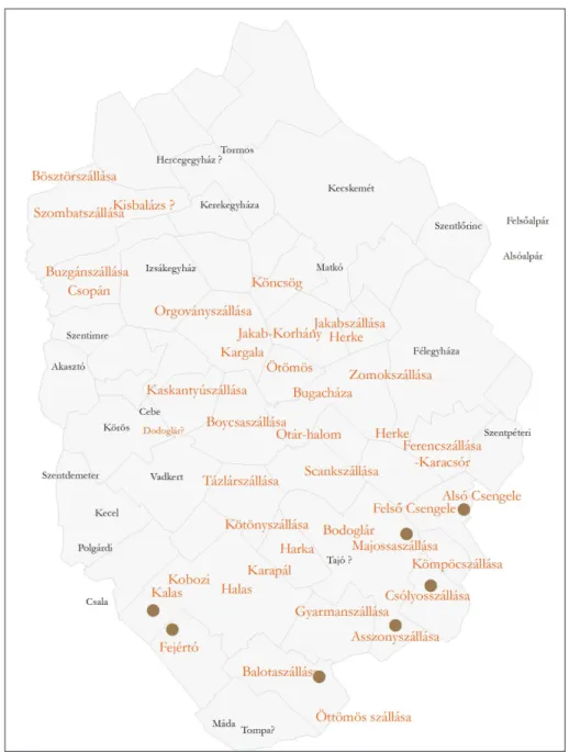
Fig. 1.The target area in Bács-Kiskun county.
The present thesis therefore adressess ’The Sand Ridges of Kiskunság’ in its title because it represents a geographical unit and also carries the cultural characteristics of the area which have been historically examined and described in this study(Fig. 1).
II. Aspects of the research
In order to reach the primary goal, a new unified system of criteria had to be created, which provided as a base for both the treatment of the various earlier data releases which had quite diverse results, and was also eligible for dealing with the enormous data gained by new and revolutionary methods that have never or rarely been used in historical settlement research before.
318
History of the settlement of the Sand Ridges of Kiskunság
In order to accomplish the main aspects of settlement studies – that is to gain use of objective and factual, consistent data that is as accurate as possible – it was first necessary to identify and validate the place of the medieval sites. This requirement, however, made it clear that the research involving all the deposits of sand ridge was physically impossible, since the exact outline of the entire local network would be available only through a previous systematic traversal and mapping of the site. In addition, other rational considerations made it necessary to narrow down the research of the originally proposed test sites. In the case of small medieval sites only archaeological research methods can be used, which have either none or just a little historical or topographical implications. Thus, the former Templar sites came to the fore as the obvious core of the medieval settlement system.
The main task of the study was to explore the medieval churches and communities built around the environment, according to the assessment criteria specified. Considering the circumstances, targeted field trips have been specified as the basis for the research, most of the new results can be described mainly by doing so. The purpose was to explore com- monly known but archeologically unknown medieval Templar sites to which any kind of field-identifiable data was available. An in-depth analysis has been done of the settlement system found in some previously systematically mapped parts of the area around Kecel and Kiskunfélegyháza, involving all the little villages. These results can be applied to the sand ridge as a whole and they also testify that the examination of larger parts would not result is more accurate results in connection with the settlement historical issues. The research revealed that a targeted investigation of the medieval Templar localities is itself capable of providing as a base for writing the history of the settlement of the area. Thus, for the funda- mental objective of the present research – for writing the settlement history of the Sand Ridge – it was the most important step to shed light on the exact sites of the medieval Templar register.
III. Methods applied during the settlement history research
The foundation, according to which the archaeological description of any settlement history era is a complex task that can only be carried out by using a complex, multi-disciplinary approach, in which even the smallest information can and has to be integrated in order to move forward, is especially true in connection with the Sand Ridges. The reason for this is the extreme lack of resources which can be accounted for the fact that we only have an extremely low rate of archaeological research done on the Middle Ages and in the other parts of the country (Hungary) such an in-depth research is almost unheard of. Therefore, in addition to the traditional archaeological and historical methods and data any other information provided by other sciences – such as the natural sciences, the language, the local history, folklore or oral tradition – is strongly appreciated. In addition, it is vital to search for new ways and opportunities as well as to involve alternative methods of settlement history that might have never or just a little been made use of in earlier studies.
Historical sources
The biggest gap in the municipal system just described on the basis of historical sources is because of the low number of potential and recoverable medieval resources that are already scarce themselves. This lack of information and resource is true in particular with regard to the
319
Szabolcs Rosta
Árpád age in the 14th century. György Györffy’s opinion clearly indicates the resource-poor situation of Kiskunság: “...the historical geography of the Kunság cannot be written based on information gained from 14th century resources. . . ”.1 Györffy’s opinion definitely reflects the real situation, that by examining settlement geography based only on the involvement of historical sources, it is impossible to access and to describe this area’s road network in the 14th century. A good example for illustrating the lack of resources is that there are only three charters mentioned from the 35 known kun value accommodation during the 14th century. The existence of the majority has been found out only in the second half of the 15th century but the former kun settlement became more archaeologically identified and defined only after the depopulation of the area known as the mere, according to the 16th century Turkish Defter data.
Not to mention the geographical names which have been preserved in other names, which are believed to have a former settlement, however historical sources are silent about them.
It is clear that the exclusive use of historical resources in connection with the 13th and 14th century in particular – though they contain valuable and vital information – is problematic and might be not adequate for a settlement history research.
Linguistics
There are numerous topics of primary importance in the Kiskunság – such as Kun rooted place names from the Kun-Kipchak group of scattered memories. In addition, there are non-trivial numbers of kun rooted geographical names that are vital in the present historical settlement research.
After the death of István Mándoky the collection and analysis of kun language memories – including geographical names stemming from Kunság – have decreased significantly. For the further collection of kun scattered memories we only have constantly shrinking opportunities in the second half of the current century because of the social and economic transformation that has currently been underway in the past century. Nevertheless, the research encountered numerous new geographical names with “a kun-suspicious root” that might be present exclu- sively in the locals’ language or on the local maps, which need further scientific evaluation.
Words which might be linked to the Kun language in the surroundings of a medieval settlement might contribute to a more detailed settlement history. Linguistic data accompanied by any historical, archaeological, geographical data relating to the neighborhood of Kiskunság provide important information about the history of the medieval towns.
Mapping – GIS
In the settlement history research of the Sand Ridge the highest assistance has been provided by cartographic materials in terms of the quantity and quality of the results. The usefulness of maps in terms of archaeology are already indisputable, as they record field phenomena, which might serve as basic information, whether it is a prehistoric Kurgan or medieval church hill. They are particularly useful in the sense that in most cases they show a total area, so they might be a basis for the reconstruction of the environment, and they might also reveal connections between various phenomena. Moreover, old maps are vital because they can show
1 Györffy 1963–1998, III. 532.
320
History of the settlement of the Sand Ridges of Kiskunság
all the elements of the contemporary landscape, which might no longer be visible. 18th and 19th century maps depicting different arts of the Sand Ridges of Kiskunság can determine the common ground points in a plane that might be a small hill in the countryside, or just prominent surroundings. Frequent cases indicate that they use geographic name for example for heaps, with reference to their characteristics. Kőhalom [Stone Pile], Csonthalom [Pile of Bones], Aranyhegy [Gold Mountain] are names that suggest human traces. The Templom- Kápolna-hegy [Temple, Chapel Hill], halom [hill], domb [hill] clearly indicate archeologically affected field points. Most of the information is carried by the 18th-century maps, which disseminate data for the late medieval period. Traces of former settlements died during the Turkish occupation, especially so called naked temples looking good also in their in their ruined state are also fundamental point of relationship between the past and the new age.
The use of GIS is an innovation in cartography, which can extract the previous options, re- interpret the results. Today, through georeferencing earlier maps by adapting them to a coordinate system distortions can be eliminated which could mean trouble for a later localization of some specific points. Thanks to modern technical innovations an accurate map region can be projected onto image data in which the 18th-century maps can give their exact location with the help of the coordinates used today. Practical importance of this innovation is that all mere church, ruin, referring to the medieval towns in the old maps – can be transferred onto maps of today’s with high-precision, so they can be easily identified on the field. Most of the maps known today for the study area became available for use, approximetaly the data of 400 maps have been built in the present thesis. 68 out of the 146 locations depicted the maps of medieval churches in some identifiable form.
The full superimposing of 18–19th century maps onto medieval settlement and road networks can only be done after an appropriate filter has been applied.2 However, the one-by-one data application and analysis has resulted in that the medieval maps turned out to possess a significantly higher importance in terms of the medieval town and the road network research.
The collection of massive amount of cartographic material is itself a huge step forward, but their data can be interpreted and successfully made use of in a historical research of medieval towns and settlements and this is what makes medieval cartography a key source for research.
Field work
The necessity and the role of field work has been indesputable since István Méri’s research of medieval villages in Nagykunság, during which he had made use of numerous field surveys and field trips.3The study area has been known as a valuable quarry due to earlier excavations and research, but the shortcomings and contradictions of the common archaeological data made it essential and necessary to identify and to make use of a number of data resulting of such research. The importance of field trips has also been enhanced by the fact that on-site monitoring made clear such relations in the case of well-known sites as well, which have been previously regarded as a matter of question by literature, so in many cases it was necessary for us to augment, correct and sometimes to override data stemming from previous findings.
2 Hatházi 2004, 12.
3 Méri 1954.
321
Szabolcs Rosta
The main aspects during the fieldwork were to collect data concerning the town’s size, location, and the age of the settlements around the given sites. The involvement of GPS significantly raised the accuracy of our field trips. The traditional field trips have been combined with metal detector tests which helped in many cases to clarify the definition of the era. During the field trips we used the typology developed during the follow-up level excavation finds having been collected to determine Ópusztaszer for over thirty years.
There are of course difficulties that arise only during the archaeological analysis of the results stemming from field trips. Through the determination of finds collected on the surface it is difficult to recognise and to detect such historical processes that excavations themselves have difficulties to clarify. In view of the subject, during the field trips it cannot be determined on the basis of material collected that whether the settlements were destroyed at the end of the 13th century because of and by the Tatar settlement or by processes that were linked to deserting, even though it often cannot be done by excavations either. There are no answers for the questions concerning the start of the plague epidemics due to deserting and the from this resulting reinstallment of settlements in the second half of the 15th century. The determination of the phases of depopulation occurring during the 16th century is difficult on the basis of data merely collected during field work. The medieval history of today’s Kiskunság is unfit in itself to decide and an- swer questions related to which settlements could be linked to the Kuns who immigrated after 1246.
IV. The center of the Sand Ridges of Kiskunság at the Árpád era:
Pétermonostora
A major excavation was carried out at the Csitári-farm site in Bugac-Felsőmonostor between 2010 and 2013, which resulted in that the center of the Sand Ridge between the 12th and the 13th century could be identified. The middle of the Danube and Tisza has a unique monastery complex that was demolished by the 14th century and is surrounded by large settlements, which can play an important role in the Hungarian medieval archaeological research in the future. These have a prominent role within the framework of this dissertation and they also provide us with long-term opportunities for the further development of complex testing methods which can be used in archaeological and historical research. Pétermonostora is a major point in this dissertation. The medieval place which could be identified as Pétermonostora had a significant impact on our knowledge of the Sand Ridges and of the middle ages between the 12th and the 13th century.
The archaeological research and excavation of Pétermonostora has enriched us with valuable finds. The quality and the quantity of the metal material found there could provide us with unexpected and unprecedent results. Apart from the iron items, more than 4000 medieval metal items were found, which enbled us to carry out an in-depth research and to draw conclusions.
The metal finds from the Árpád age were varied and rich in terms of material. Our most unique and best quality finds were two enamelled bronze plates and their associated gold-plated hinges, which were unprecedented in contemporary Hungarian commemorative material. Art historical evaluation is still pending, according to the current position they had been made in the middle of the 1180s, their style is Limoges style, which stems from the Rhine region, and they depict a series scene that relate them as an accessory to the relic which hold the reliquary of St. Peter(Fig. 2).4
4 Its art historical analysis is carried out by Etele Kis.
322
History of the settlement of the Sand Ridges of Kiskunság
Fig. 2.Reliquary of St. Peter, enamelled bronze plates.
Even if the historical sources are silent about the important life events of Pétermonostora during the 13th century, the results from the direct archaeological evidence demonstrate that the life of the village has experienced serious fracture in the mid-13th century. The collapse of Pétermonostora in the middle of the 13th century was linked to a sudden incident, for which the Mongol invasion of 1241–1242 was an obvious explanation. Pétermonostora’s importance can also be accounted for by the fact that it allows us to draw general conclusions that reach beyond its limits as well as its role as a vital quarry. Since this settlement was not spared in the area of municipal order and of impact of such processes that symbolize the whole history of ridge.
V. Key results of the complex historical research of the Sand Ridges of Kiskunság and its area
The collection of extensive medieval monuments and materials in the area has not been done until now. Extremely important is the work by Piroska Biczó, who carried out a short, but important study in 1987, which successfully sums up the literature and knowledge related to
323
Szabolcs Rosta
Bács-Kiskun County’s Templar sites in the past 30 years.5Piroska Biczó divides the Templar places in terms of the source material. With respect to the study area, she listed 16 places based on exclusively certified medieval data. 33 other church places were known from modern censuses, whereas 9 church had only archaeological data, and 6 had only geographical references.
Some of the above categories can overlap with each other. Maybe compared to the above numbers it can be shown how much progress has been made in the research of the medieval history of the Sand Ridges of Kiskunság [Kiskunsági Homokhátság]. This dissertation contains a total of 146 medieval scenes as opposed to the 60 church places said listed before. Although in the 1980s significantly more data would have been available in principle, they could not have been involved in this research because of their inaccessibility, the lack of accurate maps and other difficulties. So, essentially the collection and systematization of the already existing historical data itself resulted in a significant progress as well.
The emphasis of the data quality is quite striking if we compare it to the increase in the large number of churches. While in the 1980s, we only had data about 9 Templar place from the area, we can currently place on the map 59 late medieval churches, and 33 in addition from the Árpád age, which have been destroyed. 80% of the previous data available was only chartered mentions from a modern aspect. Compared to the previously archeologically as known classified 9 venues, the current data collection was carried out on 92 sites, with the use of a unified criterion system, which represents a more than tenfold increase.
The recognition and inclusion of new data sources and groups resulted in that 33 medieval church sites of all the 92 locations – that have been elucidated in the framework of this paper – were identified and introduced to archaeology, and were considered to be unknown before. In light of the new information earlier data had to be reinterpreted that opened up new possibilities for a number of field identification. Clarification and correction was necessary in the case of 41 sites with regard to their location, expansion, scientific age. Altogether there were only 11 medieval church sites for which we had enough adequate information, and which need not have been (re)certified.
Road networks
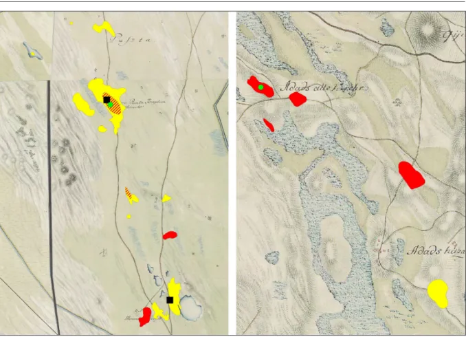
Through the georeferencing it is possible to come up with extraordinary results with regard to the road networks. The resultant of the medieval road network reconstruction and that of the medieval villages was the previous accurate map positioning. Through the relation of 18th century maps of roads and exactly identified archaeological sites, the medieval road network between the river Danube and Tisza was accurately plotted. It was essential to recognize that the 18th-century maps record the current states from the late Middle Ages, which make them suitable for determining the medieval road alignment, after having been necessarily filtered(Fig. 3).
GIS
Cartography has always brought significant figures in the science of archaeology, the inclusion of such material to a depth previously, however, was not widespread. The expansion of GIS brought about even more spectacular and more accurate maps that can be used in research.
5 Biczó 1987.
324
History of the settlement of the Sand Ridges of Kiskunság
Fig. 3.Archaeological sites from Árpád period (yellow) and Late Middle Ages (red) and the first military survey attitudes road network, Bugac and Kunadacs region.
This paper gives clear evidence that maps are one of the most important, prominent sources for the research of late-medieval settlement system. Today, we have an even more accurate and outstanding stock available for research through technical progresses and feedback.6 The importance of using maps is illustrated by that the location and the identification of more than 20 sites in the present study had been helped by them. In addition, it proved to be essential for the identification of the villages and sites from historical sources, because the boundaries of todays’ settlements do not or just partially reflect the medieval estate conditions, in many cases they have undergone a major transformation.
Hydrography
The medieval hydrographic map of the Sand Ridges of the Kiskunság was completed, which had to be taken into account in determining the local archaeological site locations as well. The probable late medieval hydrographic situations are reflected by the second military survey maps of 1960, which have been significantly altered after the drainages. While climate change research also revealed a number of smaller changes during the Middle Ages as well, this did not show any noticeable changes such as the striking of the dry period in the Sarmatian period.
The hydrographic map helped to systematically explore and detect more areas of interest while the field work. In the Árpád age the establishment of a watery environment clearly attracted settlement, there are only small deposits in the drier areas. In the late Middle Ages it
6 Thanks to the GIS work of István Pánya.
325
Szabolcs Rosta
is difficult to find even a small settlement, which would not lay in a short distance from a lake or water. This approach to water is a basically completely logical principle for organizing a settlement, nevertheless it is definitely worth using hydrographical maps for the research of settlement history in order to determine places where we might find earlier unexpected centres and settlements.
Mongol invasion and the deserting villages
The results of their research can be considered as part of the core issues in the resolution of the extent of how and to what extent the Mongol invasion and its destruction is related.
Some argue that the Mongol invasion resulted in profound changes, but it has been suggested that, based on earlier sources an earlier desertation of villages can be detected and traced as well. On the basis of the arguments meticulously put forward by thesis, the main reason for the desertation of the Sand Ridges of Kiskunság occurred during the 13th century at the time of the Mongol invasion. In connection with the Mongol invasion and its destruction of the subject area we can argue that its extent is similar to that of the adjacent counties – for which Györffy defined a rate of decay which represents at least 75%.7 This rate could be exacerbated by the fact that church premises of the Árpád age are usually more difficult to detect than later in the 14–16th century. Following the above reasoning, it is shown that destrucion rate of the settlements and villages in the Sand Ridges [Homokhátság] in the middle of the 13th century might easily reach 90–100% in mortality rates. The central parts of the Sand Ridges of Kiskunság had a desertation in the 13th century which was caused by not a natural process, but by a highly destructive happening—the Mongol invasion. As the research methods were linked to some specific micro regions of the Sand Ridges of Kiskunság [Kiskunsági Homokhátság], these numbers are only valid for the lowland parts of the country and are clearly different from mortality rate represented throughout the country.
It was shown that the ditch systems observed around some churches had originally a protective function and they can be linked to the Árpád age, specifically the 13th century. These ditch systems can be connected to the events of the Mongol invasion.
Cumanians (Kuns)
Partly related to the above results, the research was able to examine the Cumanians’ settlements and to define the early kun settlement system. The specific situation of the area comes from the fact that in the middle of the 13th century, a completely destroyed – and by this fully preserved – Hungarian Christian settlement system gave rise to a – in their customs, their language and their way of life not significantly different – Cuman transition. The available, mainly archaeological and linguistic data proved to be adequate to answer the question to what extent the Cumans used the formerly destroyed Hungarian settlements after the Mongol invasion. It is clearly seen that at least the half of their settlements did not take possession of a former settlement but they were developed by a different organizational principle. It is an important observation and the available methods can demonstrate that often a high yield shore water attract villages that were created later in their early winter quarters. It is inevitable to
7 Györffy 1963.
326
History of the settlement of the Sand Ridges of Kiskunság
mention that the Cumanian settlement system was closed. Settlements apparently arose under a law or a system – at least in their first few decades – which separated and sealed their system and society at the same time.
The Cumanian settlement area of the Kiskunság started in a more closed way than previously thought, its system already started to break up at the time of the examined sources. However, we still have little information in order to understand these(Fig. 4).
Fig. 4.Kiskunság, in the 2nd half of the 13th century.
Land use
In any case, further analysis is required to extract the issue of land use, a significant lifestyle change is demonstrated in the 13th century, based on the available data. The rainfall, so the hydrological environment remained almost constant during the Middle Ages. Although the weather conditions have changed since the 13th century, the weather was cooler. Almost
327
Szabolcs Rosta
parallel to this the municipal system had undergone an integration after the Mongol invasion and destruction, and significantly less settlements were developed both in the number and in scope. These would not justify the appearance of quicksand after the 13th century in Kiskunság.
In the given the climatic conditions during this period only human involvement could be accounted for the movement of sand. This refers to differences between the land usage during the Árpád age and the late Middle Ages, which ultimately result in differences in the various economical and management systems. Considering the Cumanians’ way of life, who were moving into the area, we can have a satisfactory explanation for these anthropogenic effects, and it can be believed that the roots of the large livestock management and the use of the plains date back to the 15th century, which have been also mentioned in historical sources(Fig. 5).
Fig. 5.Plough-land from the 13th century covered by sand, near Kiskunhalas.
Possession conditions
Because of the deserting caused as a result of the occupation, some borough area grew enor- mously. But it is also shown that some efforts in the 14th century also influenced the restocking of the early modern era by emphasizing extensive livestock farming and usage of the plains.
The outskirts of these settlements and cities grew rapidly by the end of the late Middle Ages, smelting down smaller tenancies from the Árpád era. In the area of Kecskemét a state charter of 1456 merely describes the current state of tenancies and it indicates the result of this effort.8 Nothing illustrates these intentions better than the charter from King Sigismund [Zsigmond]
from 1423, according to which the Cumanians complain that“. . . the people of Kecskemét and Kőrös . . . often make use of these fields and plains with malice aforethought, they trample and
8 Hornyik 1927, 16.
328
History of the settlement of the Sand Ridges of Kiskunság
ruin the crops on them. . . ”.9 Szeged was suing in the second half of the 15th century—taking advantage of the plague epidemics that caused population decline – for the possession of the formerly warring, and already deserted Cumanian settlement, Asszonyszállása. It seems that one of the ongoing, deliberate settlement concentrations in the late Middle Ages can be detected, which resulted in the need for a greater border design with a new type of economic policy in mind. It is certain that similar processes took place immediately after the Mongol invasion but it meant the merger of smaller possessions or areas within the frames of the former municipal systems. This is how large and small estates appeared in the late Middle Ages, depending on how many Árpád age possessions had been merged.
Efforts to increase the area meant the creation of the will to create the steppes, which lead to the settlement integration process, called village deserting. However, the historical research into the settlement of Kiskunság warned that this was not an aim of a natural process of integration and binding associated with the goal of economic development, but the final result. These processes only take place when an external – or possibly inside – factor causes a drastic change in the social scheme, which case is associated with a significant population decline. So in the case of Kiskunság there is no need to look for economic reasons behind the spectacular integration processes, which then exert their effects on society thereafter. It seems that the opposite is true, the integration is an economic result of a change generated by a social pressure which would not have occurred – at least not in such a spectacular way – if it had not been for the drastical population decrease, so without the Mongol invasion and the Turkish occupation.
The chronological questions of medieval cemeteries
As the result of the observations made in connection with the cemetery excavation of Felső- monostor it can be probable that apparent disorder of the cemeteries around the churches and the chronological difficulties resulting from this can be refined with a general view, beyond Pétermonostora. In Pétermonostora – due to its gradual rebuilding – the cemetery is both vertically and horizontally distinct, so that the burial customs can be examined in short, ap- proximetaly 30–60 year-long stages. In Kiskunfélegyháza-Templomhalom the burials from the Árpád age and the late medieval period can be easily distinguished due to fillings resulting from the landscaping. They can be separated from each other not only based on their attachments but their rites. Alajos Bélint also observed the tradition of pouring charcoal into the graves in Templomhalom.10
Recent excavations have proved beyond doubt that this rite belong to the early period without exception, they are only characteristic for the Árpád age. The graves which can be dated with the help of the coins found in them to the 11th century did not contain the trace of such tradition, that is why the tradition of pouring charcoal into graves can be dated to the 12th century in Kiskunfélegyháza as well. The skeletons from these graves had straight positions without exception, which is similar to the phenomena observed in Pálmonostora.
It could be observed that the dominance of the straight hand position was terminated. Both locations – Pétermonostora physically separately – demonstrated a tradition of hand position and attachment that was significantly different from those stemming in the 14th–16th century.
9 Hornyik 2011, 39.
10 Bálint 1956, 78.
329
Szabolcs Rosta
We may venture to assume that in the characteristics observed in here and in Kiskunfélegyháza tend to be valid for other medieval cemeteries around churches throughout the region too. Thus, it is possible to find a clue regarding the chronology of the burials during the excavations of medieval church cemeteries, even in cases too that are less obvious than those mentioned above.
City policy
In addition to events such as the Mongol invasion and the Turkish occupation which brought about big changes, a number of more or less tangible specific events are linked to the processes carried out between the 13th and 16th centuries, which affected the municipal systems. The system integrating all available data seem to fit the constanly changing, pulsing processes of medieval towns because no one can call municipal ownerships static. It was done not just in the case of Árpád age the late Middle Ages, this can show the current settings of almost all the centuries.
The characteristics of a given period of urban development can only be described with continu- ous motion, the developments can be viewed only with the recognition of persisting problems such as the lack of resources and the limited nature of the available archaeological conditions.
However, some traits are noticeable that enable us to talk about historical periods in terms of settlement characteristics. The present study attempted to break the settlement history of the Sand Ridges of Kiskunság between the 13th and 16th century into periods based on such traits.
The most important result historical research of the settlement in the Sand Ridge of Kiskunság is the creation of an accurate medieval Templar site inventory, identifying the locations on the field.
Almost every other result that can be treated with a general validity can be traced back to this.
The research system used in the present study was suitable for gaining a deeper understanding of the medieval settlement history of the Sand Ridges of Kiskunság more accurately than ever before.
References
Bálint, A. 1956: A Kiskunfélegyháza-Templomhalmi temető.A Móra Ferenc Múzeum Évkönyve, 55–83.
Biczó, P. 1987: Adatok Bács-Kiskun megye középkori építészetéhez. In: Sztrinkó, I. (ed.):Múzeumi kutatások Bács-Kiskun megyében 1986.Kecskemét, 71–80.
Györffy, Gy. 1963-1998:Az Árpád-kori Magyarország történeti földrajza I–IV.Budapest.
Györffy, Gy. 1963: Magyarország népessége a tatárjárástól a XIV. század közepéig. In: Kovacsics, J. (ed.):
Magyarország történeti demográfiája. Budapest.
Hatházi, G. 2004:A kunok régészeti emlékei a Kelet-Dunántúlon.Opuscula Hungarica V. Budapest.
Hornyik, J. 1927:Kecskemét város gazdasági fejlődésének története.Kecskemét.
Hornyik, J. 2011: Kecskemét város története oklevéltárral. Az I. kötet latin nyelvű okleveleinek magyar fordítása. In: P. Fehér, M. (ed.):Kecskeméti Örökség Könyvek I.Kecskemét.
Méri, I. 1954: Beszámoló a tiszalök-rázompusztai és túrkeve-mórici ásatások eredményeiről II.Archaeo- logiai Értesítő 81, 138–154.
330