The examination of water regulation works with the help of a geoinformatical database
in the 18th-century Kingdom of Hungary Pro&Contra 4
No. 2 (2020) 89–113.
Abstract
Due to the sporadicity of works and the limited number of resources, researching the period of water history from the end of the Turkish period to the great management works of the 19th century is a more challenging task compared to the study of later periods.
Concentrating on the first military survey, this study aims to provide a comprehensive picture of the flood relief works of the 18th century on the basis of the maps of the territory of the Kingdom of Hungary. During the study, water features (embankments, channels, etc.) that could be identified on the military survey sheets were recorded in a GIS database. The main objective was to be able to compare these works in terms of volume (built embankment and channel lengths) and spatial distribution with the water management works of later ages. Although undoubtedly a reliable source for the study, the first military survey only allows the creation of a “basic database” therefore this present study presents the results of the first phase of a larger project.
Keywords: history of water management, water management works, first military survey, GIS, database, 18th century
Introduction – framework of research
Due to the Carpathian Basin’s distinctive hydro-geomorphological conditions, water management has always been an economic and governmental priority and remains so.
It is no wonder that water management studies have a long tradition. As far back as the end of the 19th century - 50 years after their formation, water management associations completed their written history,1 and in the second half of the 20th century, a separate archive was established for managing water management documents. In the early years, water management history dealt with institutional and technical approaches where the relevant studies were rather descriptive and less analytic. New historical auxiliary sciences emerging in the 20th century, such as historical geography and historical ecology (or environmental history) approach “water management” in a much more complex way since they focus on the relationship between landscape and society while water management organisation and
1 Klára Dóka: The management of water works and their economic importance in Hungary. 1872-1918.
Budapest, 1987. 6-7.
technology can be found as a single aspect here. Thanks to the economic importance of the agricultural sector and to the major socialist water management investments, the 20th century provided a favourable social sphere for research on water management history;
these researchers maintained the momentum up until the turn of the millennium. Studies have been given a new boost from research and social interest in increasing environmental problems (e.g. climate change, decreasing water level, aridity changes) however, these investigations already formed part of the field of environmental history. Regrettably, the amount of water management research is declining before debate in the subject could have made a real difference by providing a sufficiently accurate picture of the past of water management. Despite the fact that the author’s doctorate research primarily focuses on environmental history, the content and methodology of this study are closer to the traditional history of water management and historical geography although it also seeks to identify shortcomings in these fields which need to be addressed to evaluate the relationship between landscape and society thoroughly.
For the sake of clarity, some basic concepts require further clarification and what they mean in the framework of this study. Water management refers to society’s water use for economic purposes where elements (cleaning of oxbows, establishment of fishponds) of oxbow lake management (in line with the relevant ecological conditions) are also included in the term. It also refers to 19th century water regulation works (e.g. building of dams) aiming to drain floodplains and are irrespective of the previous aspects. Water regulation refers to a procedure where farming communities transform the hydrographical system of their environment: all forms of anthropogenic interventions shall be included here.
After the Turkish wars in the 18th century, the Great Plain areas mostly affected by floods underwent economic reorganization which was accompanied by an increase in the number of anthropogenic interventions. This study is primarily an attempt to examine the extent of man-made landscaping for water regulation purposes in the century - in the first century of intensive landscaping period since 1700 – also, what regional differences can be found and how these differences can be compared to later works.
“Eras” of water regulation
Flood relief and river regulation works the Carpathian Basin can be divided into three main eras based on the concepts, organisation, financing and construction.
The first is the so-called “local water regulation era” which saw some minor works initiated and implemented by local owners. This era began in the first half of the 18th century and ended roughly in the middle of the 19th century. The procedure’s starting
point was the post-Turkish economic reorganisation, while the endpoint can be found around the launch of corporate regulations.
The second is the so-called “regular” or “classic” river regulation era where the Tisza- Valley is usually associated with the name of Pál Vásárhelyi. The 1846 establishment of the Tiszavölgy Association or the ceremonial Tiszadob hoeing, initiated by István Széchenyi in 27th August 1846 marks the era’s symbolic starting point. This period is characterized by river-wide works, where significant and vital interventions were made by the whole association. After 1846, 2,700 kilometres of embankments were built in the Tisza Valley alone leading to relieved flood pressure in 3 million cadastral acres.2 Due to the radical economic, social and political changes, the WWI and WWII can be marked as the endpoint of this era.
The third is the so-called “modern water regulations era” which began in the middle of the 20th century and continues to this day. Compared to the previous two eras, this period saw the increasing significance of dewatering, irrigation and water storage while environmental aspects also came into the picture. The era’s major works included the construction of Tiszalök and Kisköre Dams and their inland water drainage and irrigation channels.
Characteristics of the local water regulation era, challenges of the investigation Due to the size of works, little scientific interest and the challenges of previous research, the era of “local water regulations” is underrepresented in the historical literature of water management history and economic history.
Studies for the period before 1850 can be divided into two main groups: One group includes water history research that essentially seeks the historical roots of modern water management, and the other includes those that wish to reconstruct 3 contemporary floodplain management. The long-term aim of the latter is to explore the complex system
2 Imre Botár –Zsigmond Károlyi: Management of the Tisza 1846-1879. in: Vízügyi Történeti Füzetek 3. Buda- pest, 1971. 19.
3 Floodplain management: A concept that includes oxbow lake management but is much broader. Floodplain management refers to the differentiated management of riverine communities, which includes “passive”
land use systems, as opposed to “oxbow lake management”, which adapt to the floodplain environment and make use of it, but do not include water diversion or treatment (this is also determined by the environmental conditions, because where there are no oxbow lakes, there can be no oxbow management). In a stricter sense, oxbow lake management was characteristic only of a narrower group of riverine communities, however, the conceptual scope of floodplain management included the management systems of most riverine communities before the comprehensive river regulations of the 19th century.
of relations between landscape and society, its changes and the reasons for the changes and to assess in the context of later events whether these processes had a positive or negative impact. Some of the anthropogenic hydrological interventions of the 18th century - dam construction and sewerage - cannot yet be clearly considered as an indicator,4 of the changing approach of land use; there is no doubt, however, that in the century, especially in the last third, we will find many examples of water management works that ignore ecological aspects and can be seen as a precedent for later comprehensive work, which are compatible with the mercantilist and physiocratic approach of government.
Another feature of the relevant professional literature is the lack of synthesis of the results of comprehensive research, which is mainly due to the fact that the momentum of the historical study of water management had decreased before the actual works were realized (it should be noted that this would require serious resources and research collaboration). Our knowledge on 18th century water management is therefore scattered and compared to other periods, little information can be found about the era of local flood relief. Studies about water management history introduce the given era with the help of a major construction or by analysing such factors as the emergence of engineer training or mapping works. This does not necessarily mean that comprehensive studies on water management are non-existent (see the accounts of Dénes Ihrig5, Klára Dóka6, Woldemár Lászlóffy 7, Csáth – Deák – Fejér – Kaján8): it simply means that these accounts paid little attention to 18th century works and their analysis was extremely limited due to the available resources. As far as historical science is concerned, there hasn’t been a comprehensive qualitative assessment on the era; thus these works cannot be compared to the complex river regulations. Some aspects of the procedures are very uncertain:
territorial distribution (e.g. should we investigate according to river sections or country regions?) and the size of the works (e.g. length of embankments, channels, etc.).
4 An excellent example of this is one of the most significant early works in the Middle Tisza region, the so-called Construction of Mirho Dam. With a great historical interest in the 1980s, the work carried out mainly by the population of Nagykun settlements and even conference proceedings were published in connection with the memorial conference held in Kisújszállás in 1987 on the occasion of the two-hundred-year anniversary of the construction of the dam. Most of the researchers considered the construction to be the antecedent of the great Tisza regulation of the 19th century and believed that the construction introduced a new era of land use in the area. In contrast, however, there are some circumstances - e.g. the relatively lengthy period between the construction of the Mirhó Dam and the subsequent work – which suggest that farmers did not yet want to give up their primarily livestock-based farming system around the floodplains.
5 Dénes Ihrig (ed.): A magyar vízszabályozás története. [The History of Hungarian Water Management] Bu- dapest, 1973.
6 Dóka Klára: The management of water works and their economic importance in Hungary. 1872-1918.
7 Woldemár Lászlóffy: The Tisza. Budapest, 1982.
8 Csath – Deák– Fejér – Kaján: Magyar vízügytörténet. [History of HungarianWater Management] Baja, 1998.
The challenges of investigating local water management are to be found in the source characteristics of the 18th century and in the organizational characteristics of the works. In the 18th century, the water directorate was still in its infancy and, although water management procedures received significant subsidies from royalty, the river engineering and architecture department of the Hungarian Chamber, founded in the 1770s, and the Shipping Directorate, established in 1776, had little efficiency and they achieved significant results in the field of mapping and in the Duna area only. 9 In the second half of the 18th century and in the first of the 19th century, several royal commissioners were appointed but it had also little effect. Károly Sigray in the Sárköz area and Lőrinc Orczy in the Upper- Tisza area met with the resistance of the counties and landlords were not really interested in the works either.10 Orczy, also a royal guard and writer, was sceptical right after his appointment and his poem showed the situation:
“a man is to be found
who, defying suffering, can patrol the country up and around let’s send Orczy and give him a chance,
to do a great thing without finance”
Orczy’s illustration proves that water management works could only be completed by the cost of local landlords or counties and the procedure itself was executed by public workers and its organisation was by no means an easy task. Since the recently established water management organisations and the appointed royal commissioners could offer limited financial support, and they often merely encouraged the procedure, the control of the procedure was also problematic. As a result of this, findings of the works (especially those ones which were executed on less commercially preferred water systems) cannot be found in any central statistics. Operating between 1773 and 1788, only the Shipping Directorate’s index and register and the reports of 1785/1786 can be found in the archives of the board of governors. The latter is 984 pages long and includes not only water management procedures but also reports on road and bridge constructions11 Documents on water management can also be found in the archives of the Hungarian Chamber but these mainly focus on the Duna area and the water constructions in the chamber lands.12 The highest number
9 Klára Dóka: The management of water works and their economic importance in Hungary, 8-28.
10 Dénes Ihrig (ed.): A magyar vízszabályozás története. [The History of Hungarian Water Management], 64-68.
11 Ibolya Felhő: A helytartótanácsi levéltár. A Magyar Országos Levéltár kiadványai I. [Archives of the Board of Governors. Papers of the Hungarian National Archives] Levéltári Leltárak 3. Budapest, 1961. 503-505.
12 István Nagy: A Magyar Kamara és egyéb kincstári szervek. [The Hungarian Chamber and other treasury divisions. Papers of the Hungarian National Archives] A Magyar Országos Levéltár kiadványai I. Levéltári
of relevant documents can be found in the county of municipal archives. These records, letters and other documents provide a good basis only for research: complex quantitative assessments cannot be elaborated based on these accounts.
Sources of research, the basic database
Stored in archives, survey maps in a manuscript form are the most common sources of water management. In connection with water management works, plans were made in all cases and most of them can still be found in the archives of the board of governors, chambers or in local county map collections. Completed works are indicated on such major maps as military investigations or comprehensive mapping prior to regular managements.
Maps had already been used in water management research previously however, geoinformatics provides a more updated, more precise and quicker data-processing. This research primarily aims to create a geoinformatical database in which specific works can be recorded.
The primary source of analysing the 1700–1800 period was the first military investigation and I also consulted minor works including the map sheets of Tisza mapping created by János Litzner between 1783 and 179013. The latter primarily functioned as a control source of the military investigation. Thus, in accordance with the first military survey, the database presented in this study contains water management projects before 1782–1785 and a significant number of them were created in the period after 1700.
Map sheets are based on the georeferenced version of the DVD ‘First Military Investigation: Kingdom of Hungary’, published by Arcanum. The projection is used with the Unified National Projection System (hereinafter: UNPS). For later publication, it would have been more obvious to take Mercator WGS84 base map which is commonly used on online platforms. However, we used EOV in all of our investigations in the Middle Tisza area identicality was our main goal here as well. Since the later transformation of the database’s vector layers can be completed easily, it further strengthened our choice.
Those flood relief works which can be identified on the map sheets of the first military investigation, were recorded on a vectorial map: this functions as the basis of the database. According to the type of works, these were recorded on 3 different layers:
embankments, channels and riverbed control works. Within the main type of works, there
leltárak 9. Budapest, 1995. 210-212.
13 Litzner and Sándor. Tisza folyó vízrajzi térképe. [Water Management Map of the Tisza] Hungarian National Archives (Hereinafter: HNA) Archives of Heves County. T 117.
are some attributes connected to lined items: relatable water flow or standing, the section in case of bigger water flows, type of channel or embankment, administrative unit. These will be detailed later on.
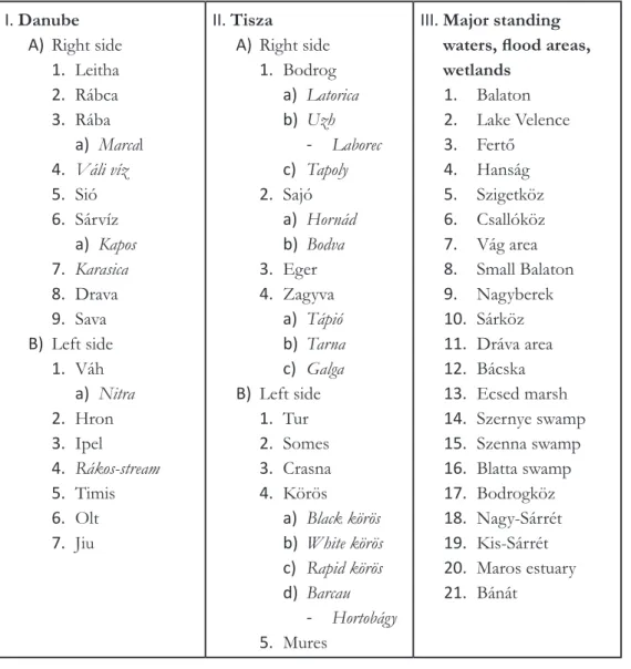
The territory of the Hungarian Kingdom was depicted in 965 sections in the military investigation. Given that most of the section sheets depict mountainous areas which are less relevant for water management investigations, we conducted a targeted research instead of processing all sheets. This research focuses on areas next to the potential rivers or standing waters. During the research, we strove to examine river and lakeside areas as widely as possible considering flood line identified on maps. By examining embankments carefully, the investigation was completed systematically by starting with the big rivers and ending with the tributaries. The list of the investigated rivers, standing waters and marshes are included in Table 1.
I. Danube A) Right side
1. Leitha 2. Rábca 3. Rába
a) Marcal 4. Váli víz 5. Sió 6. Sárvíz
a) Kapos 7. Karasica 8. Drava 9. Sava B) Left side
1. Váh a) Nitra 2. Hron 3. Ipel
4. Rákos-stream 5. Timis 6. Olt 7. Jiu
II. Tisza
A) Right side 1. Bodrog
a) Latorica b) Uzh
- Laborec c) Tapoly 2. Sajó
a) Hornád b) Bodva 3. Eger 4. Zagyva
a) Tápió b) Tarna c) Galga B) Left side
1. Tur 2. Somes 3. Crasna 4. Körös
a) Black körös b) White körös c) Rapid körös d) Barcau
- Hortobágy 5. Mures
III. Major standing waters, flood areas, wetlands
1. Balaton 2. Lake Velence 3. Fertő 4. Hanság 5. Szigetköz 6. Csallóköz 7. Vág area 8. Small Balaton 9. Nagyberek 10. Sárköz 11. Dráva area 12. Bácska 13. Ecsed marsh 14. Szernye swamp 15. Szenna swamp 16. Blatta swamp 17. Bodrogköz 18. Nagy-Sárrét 19. Kis-Sárrét 20. Maros estuary 21. Bánát
Table 1. Investigated areas
The first military investigation was conducted on a small scale compared to water maps, so there was a possibility that certain defences or other artefacts would not appear on it due to their size. This can be offset by the fact that, from a tactical point of view, the location of embankments and channels is significantly relevant thus their inclusion was a priority.
In the Middle-Tisza area which had been thoroughly examined previously, a mapping was conducted at the same time as the military investigation. This mapping was however independent from the military one and it focused on regulation for the first time. János Litzner, engineer of Heves and Outer-Szolnok counties, surveyed the section between Bábolna and Tiszasas and the surrounding areas between 1783 and 1790. He depicted the
results on 48 map sections. It was obvious for us to use this supposedly accurate map as the control source of the military investigation. On the Litzner map, traces of 44 works can be found and all of these (except two) are easily noticeable in the military investigation as well. Based on these, it seems that the less detailed military investigation is also a reliable source of water management history although one that did not primarily focus on water management.
Unfortunately, a unified system of signs was not used during the military investigation which made it difficult to separate embankments from roads or identify channels. The legend for this was compiled in 1932 by Andor Borbély and Júlia Nagy.14 Dam as sign category is missing in this account; only road-related embankments appear in this as a
“loaded road” and “dam-road”.
Embankments in the first military investigation
14 Annamária Jankó: Magyarország katonai felmérései [Military investigations in Hungary]. Arcanum Kézikönyvtár.
https://www.arcanum.hu/hu/online-kiadvanyok/Janko-janko-annamaria-magyarorszag-katonai-felmere- sei-1/ (2019.06.14)
Traces of water management works are therefore unclear in some cases: that is why, one of the most important attributes of channels and embankments is that they can be identified precisely or unclearly. Having regard to the fact that the depiction of artificial channels is not different (or slightly different) from natural waters, then those are categorised as “hypothetical” more often. Due to the lack of such inscriptions as “canal”, channels (to collect water or for the purpose of a given water management procedure), can only be separated according to a straight line. However, given that the survey of waterbeds extending in the middle of marshes and reeds was problematic for the workers, natural watercourses are depicted as more angular and more straight on wetlands.
Separate categories within channels: drainage and water collecting channels, digging of waterbeds, cleaned oxbow lake, bend cut-offs, a mill channels/ship channels/other channels.
In order to find out the category of the given artificial watercourse, the categorisation considered the environment (especially hydro-geomorphological conditions) based on the following aspects:
Channels which start flowing from a deep point of marshes and wetlands and heading towards the closest natural watercourse shall belong to “drainage and water collecting channels”. Short channels in the Great Plain area connecting waterbeds or its close surroundings with the edge of marshes/reeds: belong to the “cleaned oxbow lake category”.15 The strikingly straight waterbed section which can be observable in the line of watercourse beds and can clearly be separated from its environment (from the previous and from the next section) belong to the “digging of waterbeds” section.
The strikingly straight channels which shorten the length of waterbeds belonged to “bend cut-offs”. Within embankments, we have the following categories: distributary closure (mainly along the upper section of the Danube), flood relief embankments, mill dams and road embankments. Flood relief embankments and road embankments overlap with each other and all embankments had separate attributes which indicated whether the embankment had a traffic function or not (road embankment: yes/no). Road embankments include those embankments which run through marshes or floodplains, their embankment nature is indicated with stripes however, certain facts suggest that these embankments do not (or only slightly) prevent water flow: as far as flood relief is concerned, their characteristics are illogical, are surrounded by water on both sides and their line may be interrupted by
15 This procedure is associated with the broader definition of Zsigmond Károlyi’s oxbow lake: ruptures on ridges or such holes which interrupt high banks: through these, flood water reaches the floodplain and during subsiding, they drain the surrounding marshes through the same ridges and holes. Károlyi – Nemes: Szolnok és a Közép-Tiszavidék vízügyi múltja. I. Az ősi ártéri gazdálkodás és a vízi munkálatok kezdetei (895-1846) [Water management history of the Middle Tisza area I. The beginnings of the traditional floodplain farming and water management works] Vízügyi Történeti Füzetek 8. Budapest, 1975. 16.
bridges. Flood relief embankments include those embankments which separate dry and wet lands and their characteristics are logical. If the map shows that a road runs on a given embankment (or on its section), then this belongs to the road and flood relief embankment category with mixed purposes. Here, its traffic function is also indicated.
Due to the simple, striped topography, maps do not make it possible to calculate the exact size (diameter, depth, canopy level, bending of banks, etc.), of flood barriers and channels: only their length can be indicated. This error can be corrected by using other relevant sources and maps (e.g. more precise blueprints) during the extensive research.
Findings of the first military investigation
374 embankments and channels could be identified on the maps of the first military investigation in the Kingdom of Hungary. From these, 254 were clearly identified. There were 374 works altogether in 34 counties: 42 works were being completed in Bratislava.
From these, there were 22 drainage works and 20 embankment constructions. A significant number of works took place in Tolna, Somogy, Pest-Pilis-Solt, Szabolcs, Békés, Zala, Heves and Outer Szolnok counties. The works were completed in 165 settlements: from these, embankment flood relief works took place in 114 areas, while drainage works were being completed in 51 areas.
The number of comprehensive water management works can be calculated by collecting all works in a given settlement. The highest number of anthropogenic interventions took place in the Great Plain (51%); however, if we consider the number of newly constructed channels/embankments and their length, the Transdanubian region saw the most works (61%).
0,0 10,020,0 30,0 40,0 50,060,0 70,0 80,0 90,0
number (%) length (%) number (%) length (%) number (%) length (%)
chanelling embankments overall
Territorial distribution of works based on the largest regions
Great Plain Transdanube Upper Hungary
Graph 1. Territorial distribution of embankments and channels identified in the first military investigation based on the largest regions
Not surprisingly, the majority of 374 works related to the two biggest rivers: the Danube (103) and the Tisza. The highest number of works took place on such Danube tributaries as the Vág, Sárvíz and the Kapos, while Tisza tributaries like the Körös and the Berettyó also saw several works. If we consider the number of newly constructed channels/
embankments and their length, the following were prominent: Danube (405 km), Tisza (202 km), Sárvíz (138 km), Lake Balaton (78 km), Vág (70 km), White-Körös (44 km) and the Drava (29 km). It is therefore concluded that the economically more developed Transdanubian region and the southern region (which received more attention due to the large number of chamber lands) had more construction although there were major works in the Tisza area and along its tributaries.
In the professional literature, anthropogenic landscape shaping is mainly associated with population density (overpopulation) and economic growth (extensive agricultural growth).16 The newly developing geoinformatical database is planned to be suitable for the statistical analysis of the relationships between landscape formation and growth on a national scale however, this will be detailed in a different study although the results of some simpler preliminary studies are worth mentioning here. The correlation between population density and the territorial distribution of works may indicate a relationship between population growth and the intensity of water management. Joseph II’s population census
16 Klára Dóka: Gazdálkodás a Tisza árterein a XIX. század első felében. [Farming on Tisza in the first half of the 19th century] Agrártörténeti Szemle, 24. évf. (1982) 3-4. sz. 292-293.
took place at almost the same time as the military investigation therefore, the combined use of data in the analysis is evident. Based on the census, population density of the counties was published by Dezső Danyi and Zoltán Dávid in 1960. 17. I examined the correlation between the population of the 34 counties involved in the water management works and the intensity of landscape formation in terms of the total work/population density, the embankment/population density and the drainage/population density completed in each county in terms of number and size of works (embankment and channel lengths). The statistical correlation between population density and the number and size of works proved to be weak, with a correlation coefficient of -0.24 and 0.34 for lengths for embankment and drainage, and -0.110 and 0.009 for the number of works. A correlation coefficient above 0.2 indicates a “certain but weak” correlation. Based on these, it appears that embankment is associated with lower, while drainage is associated with higher population density. Given that the hydro-geomorphological conditions in Transdanubian regions (Sárvíz area, Lake Balaton, Fertő and Hanság, etc.), characterized by higher population density, more intensive and market-oriented farming, drainage seems to be more necessary while in the sparsely populated, lower-lying and weaker areas of the Tisza region, the embankment is the more obvious method of water management. Based on these, the results are not surprising at all.
Overall, during the period of local water management, it seems that the hydrological environment and the extensive population growth pressure were equally significant while higher population density and economic development do not necessarily go hand in hand with greater concentration of the works.
17 Danyi – Dávid (eds.): The first Hungarian census (1784-1787). Budapest, 1960. 55.
Population density (persons/km2 )18 Embankments
and channels Embankments Channels Length
(m) number Length
(m) Number
of works Length
(m) Number of works
Abaúj 39,9 7971 10 7971 10
Arad 25,5 13460 5 1602 2 11858 3
Bács 17,9 77737 6 6818 3 70918 3
Baranya 37,7 6753 2 6753 2
Bars 36,3 1028 1 1028 1
Békés, Csanád, Csongrád
17,3 131477 46 44790 24 86687 22
Bereg 18,1 9396 2 9396 2
Bihar 28,7 2117 3 2117 3
Borsod 37,6 2119 1 2119 1
Esztergom, Komárom
32,5 57619 17 21730 3 35889 14
Fejér 23,8 96342 9 96342 9
Győr, Moson 34,4 66951 16 48147 8 18804 8
District 3 19,8 15231 17 15062 13 168 1
Heves 24,8 17749 19 12915 16 4834 3
Hont 30,1 1200 1 1200 1
Nyitra 50,3 48056 11 45638 8 2418 3
Pest 25,1 110456 23 47263 6 63193 17
Pozsony 42,7 102208 42 74777 20 27431 22
Sáros 35,7 1608 1 1608 1
Somogy 24,8 71955 27 20660 8 51295 19
Sopron 43,8 24419 5 24419 5
Szabolcs 23,4 38081 22 24208 19 13873 3
Szatmár 22,9 59800 12 50430 7 9370 5
Tolna 37,7 54800 28 4993 9 49807 19
18 Danyi – Dávid (eds.): The first Hungarian census. 55.
Population density (persons/km2 )18 Embankments
and channels Embankments Channels Length
(m) number Length
(m) Number
of works Length
(m) Number of works
Trencsén 46,9 1362 2 1362 2
Ugocsa 17,3 8639 7 3579 4 5059 3
Vas 40,1 15106 9 15106 9
Veszprém 36,2 30602 5 5725 3 24878 2
Zala 37,7 76860 20 16156 3 60704 17
Zemplén 33,3 1455 1 1455 1
Correlation with population density:
-0,226 -0,163 0,240 -0,110 -0,348 -0,009 Table 2. Embankments and channels built until the end of 18th century in the
Kingdom of Hungary
Building embankments
374 works were identified where 169 were embankments. From these, only 22 were uncertain. Up until the military investigation, the total length of embankments was 517 km of which 447 km were flood defence embankments, 57 km were road embankments and 11 km were road and flood defence embankments for mixed purposes. Built by 1785, the 447 km of flood defence embankment was 10% of the 4,000-kilometre-long embankment built during the period of systematic regulations that began around 1850. The volume of works was thus insignificant in comparison to later periods.
56% of the embankments are connected to the Danube and its tributaries, 26% to the Tisza and its tributaries while 18% to standing waters and marshes. Data are in line with preliminary expectations since many more embankments were built in the more agriculturally developed western Danube areas. However, it is important to note that only one of the two most extensive embankment systems, the Csalló and the Szigetköz, is connected to the Danube while the other can be observed in the Upper Tisza Region. In 1782, the longest continuous embankment line in the country was also built in the Upper Tisza Region, in Bereg-Satu Mare County, with a length of 57 kilometres. It is followed by the 33 km long embankment in Pest-Pilis-Solt county in the Baja area although this can only be identified with uncertainty.
18%
56%
26% Standing waters and marshes
Danube and tributaries Tisza and tributaries
Graph 2. Embankments lengths in water systems
Due to the hydro-geomorphological features of the area, nearly 80% of road embankments and flood defence embankments (also functioning as road embankments) belong to the floodplain of the Tisza and its tributaries. On the high banks of the Danube, inland transport was possible without the formation of road embankments while in the wetlands of the Tisza it was essential to create such embankments and, in addition, the maintenance of salt roads was an important interest of the Chamber. That is why 43% of those embankments which function only as road embankments could be found in two administrative units, Csongrád and Heves-Outer Szolnok counties. The Debrecen-Szolnok-Pest salt road which is very important in the transport of Transylvanian salt runs on the latter in an east-west direction”19. It passes through the edge of the marshiest areas of the country (Nagy- and Kis-Sárrét).
0,00 20,00 40,00 60,00 80,00 100,00 120,00 140,00 160,00 180,00 200,00
Duna Duna mellékfolyói… Csallóköz és… Vág Marcal Sió Tapolca Kapos Koppány Dráva Mura Tisza Tisza mellékfolyói… Szabolcs-Szatmár-… Felső-Tisza Közép-Tisza Alsó-Tisza Körös Maros Sebes-Körös Berettyó Hortobágy Zagyva Sajó Szamos Takta
ezer
Length or river embankments (km)
Graph 3. Length of river embankments and major embankment systems
19 Mihály Szikszai: Jász-Nagykun-Szolnok Megye közlekedéstörténete. [The history of transport in Jász-Nagykun- Szolnok county] Jász-Nagykun-Szolnok Megyei Levéltár Közleményei 7. Szolnok, 2005. 9-10.
Channelization
The total length of the 203 artificial channels depicted in the military investigation was 692 km of which 463 km were channels for draining marshes and other runoff areas while 95 km were riverbeds helping drain off floods. These were largely land reclamation interventions for the benefit of farming and water management works in larger manorial areas and appear in relatively large numbers in the water history literature.20 Drainage works were mostly carried out on large estates where they were producing goods: an example is the Festetics manorial in Keszthely where the drainage channels of the manor also appeared in the sheets of the military investigation.
67%
16%
10%
2% 2% 3%
drainage channel run-off and riverbed digging
shipping channel darainage channel mill channel other channels
Graph 4. Ratio of channel types based on their lengths
The longest continuous shipping channel was the Ferenc Channel built in Bácska, the works of which began only in 1793, seven years after the military investigation. However, a significant section of the channel - presumably in view of the advanced state of planning - was indicated on the sheets of the military maps. The most extensive drainage channel system was established in Fejér County with the management of Sárvíz and its surroundings.
The longest continuous channel was 55 km long and a total of 138 km of channels were built in the Sárvíz area until the military mappings.
20 See.: Ihrig : The History of Hungarian Water Management. 62-64.
121781
33073
406245
131875 0
50000 100000 150000 200000 250000 300000 350000 400000 450000
Other standing
water and marshWater system of
Lake Balaton Water system of
the Danube Water system of the Tisza
Graph 5. Total length of channels in connection with the different water systems (m) Final conclusions
In a comprehensive account ‘The History of Hungarian Water Management’, edited by Dénes Ihrig 41 particular works are mentioned from the period before 1785. From these, 29 were accurately identified in the military investigation while 4 were not relevant as they took place in Banat and Transylvania. In contrast, 374 specific works were identified in the military investigation therefore we have a more accurate picture of the period of local flood relief than in the compilation of the history of water management. In her account
‘The management of water works and their economic importance in Hungary’, Klára Dóka puts an emphasis on 14 counties which were overrepresented due to their hydrographic conditions.
31% of the channels recorded in the database and 52% of the flood defense embankments can be found in these counties it is true, therefore, that most of the works focus on these areas, but if we want to give a detailed account of the waterworks in the 18th century, our research area must be wider than that designated by Dóka.
It can finally be noted that the works carried out in in the Upper Tiszavidék, are as significant as the construction in Transdanubian regions, which were over-represented in the literature. Based on the final overview map, the locations of the necessary comprehensive works are thoroughly outlined.
In the future, works appearing on the current mappings need be added to our database since their scale is smaller and can be outlined in greater detail. The next step is to match the database with maps collected from the Archives of the Governor’s Council. According to our preliminary survey, almost three hundred water management maps for the period before 1850 can be found in the map archive.
After processing these maps, we will have a much more detailed picture about the period of local water management.
References
Andrásfalvy, Bertalan, A Sárköz ősi ártéri gazdálkodása [The ancient floodplain management of Sárköz] Budapest: Vízügyi Dokumentációs és Tájékoztató Iroda, 1973.
Botár, Imre and Károlyi, Zsigmond: A Tisza szabályozása 1846-1879 [Regulation of the Tisza 1846-1879] Budapest: Vízügyi Dokumentációs és Tájékoztató Iroda, 1971.
Csáth, Béla, Deák, Antal, Fejér, László, and Kaján, Imre: Magyar vízügytörténet [Hungarian history of water management] Baja: Eötvös József Főiskola Műszaki Fakultás, 1998.
Danyi, Dezső, and Dávid, Zoltán: Az első magyarországi népszámlálás (1784-1787). [The first census in Hungary (1784-1787)] Budapest: Statisztikai Kiadó Vállalat, 1960.
Dóka Klára: “Gazdálkodás a Tisza árterein a XIX. század első felében” [Farming in the floodplains of the Tisza in the first half of the 19th century] Agrártörténeti Szemle 24, no.
3-4 (1982): 292–293.
Dóka, Klára: A vízimunkálatok irányítása és jelentősége az ország gazdasági életében. [Management and significance of water works in the economic life of the country 1872-1918.] Budapest: Mezőgazdasági Ügyvitelszervezési Iroda, 1987.
Felhő, Ibolya: A helytartótanácsi levéltár. [The Archives of the Council of Governors] Budapest:
Akadémiai Kiadó, 1961.
Ihrig, Dénes ed.: A magyar vízszabályozás története [History of Hungarian water regulation]
Budapest: Országos Vízügyi Hivatal, 1973.
Jankó, Annamária: Magyarország katonai felmérései [Military surveys of Hungary] Budapest:
Arcanum Kézikönyvtár. https://www.arcanum.hu/hu/online-kiadvanyok/Janko-janko- annamaria-magyarorszag-katonai-felmeresei-1/.
Károlyi, Zsigmond, and Nemes, Gerzson: Szolnok és a Közép-Tiszavidék vízügyi múltja. I. Az ősi ártéri gazdálkodás és a vízi munkálatok kezdetei [The water management history of Szolnok and the Middle Tisza region. I. The beginnings of the ancient floodplain management and water works] (895- 1846). Budapest: Budapest: Vízügyi Dokumentációs és Tájékoztató Iroda, 1975.
Lászlóffy, Woldemár: A Tisza. Vízi munkálatok és vízgazdálkodás a tiszai vízrendszerben. [The Tisza. Water works and water management in the Tisza water system] Budapest: Akadémiai Kiadó, 1982.
Nagy, István: A Magyar Kamara és egyéb kincstári szervek [The Hungarian Chamber and other treasury bodies] Budapest: Magyar Országos Levéltás, 1995.
Sugár István: A Közép-Tiszavidék két kéziratos térképe [Two manuscript maps of the Middle Tisza region] Eger: Dobó István Vármúzeum, 1989.
Szikszai, Mihály: Jász-Nagykun-Szolnok Megye közlekedéstörténete [Transport history of Jász- Nagykun-Szolnok County] Szolnok: Jász-Nagykun-Szolnok Megyei Levéltár, 2005.
Tóth, Albert ed.: “Áldás és átok a víz” Tudományos emlékülés a Mirhó gát építésének 200. évfordulójára [Water is a blessing and curse at the same time: Memorial meeting for the 200th anniversary of the completion of Mirhó dam] Kisújszállás: Kisújszállás Város Tanácsa, 1987.