IDENTIFYING NATURA 2000 HABITATS
IN THE WATERSHED OF THE MIDDLE SECTION OF THE DEVOLL RIVER (SOUTHEAST ALBANIA)
Marjol Meço1*, Alfred Mullaj2, Ajola Mesiti2 &
Ermelinda Mahmutaj2
1*Department of Biology, Faculty of Natural Sciences, University of Tirana, Albania;
mariol.meco@yahoo.com
2Flora and Fauna Research Center, Faculty of Natural Sciences, University of Tirana, Albania
Meço, M., Mullaj, A., Mesiti,A. & Mahmutaj, E. (2018): Identifying Natura 2000 habitats in the watershed of the middle section of the Devoll river (Southeast Albania). – Studia bot. hung. 49(2):
73–81.
Abstract: Th e watershed of the middle section of the Devoll River is located between the districts of Korçë, Pogradec, and Gramsh. Th e geographical location of this area, complex topography, cli- mate characteristics, diff erent rock substrates and soil types as well as hydrological conditions, contribute to a rich fl ora and diversity of natural habitats. Our main goal was the identifi cation and mapping of Natura 2000 habitat types within the study area, based on mainly their typical plant species. Th e mapping was carried out during the period 2016–2018. Th e most representative habitats in the area are: (sub-)Mediterranean pine forests with endemic black pines (9530), Panno- nian–Balkanic turkey oak–sessile oak forests (91M0), Quercus trojana woods (9250), and Quercus ilex and Quercus rotundifolia forests (9340).
Key words: fi eld study, GIS, forests, maquis, riparian vegetation
INTRODUCTION
Th e watershed of the Devoll River is located in the southeastern part of Albania where a relatively more continental, sub-alpine climate prevails, but with Mediterranean infl uences in the lower altitudes. Th e study area covers the water- shed of the middle section of the Devoll River. Its surface is around 1,017 km2, about the 3.5% of the area of Albania. Due to the high range of altitudes (from 100 m to 2373 m), the complex topography, the highly variable rock substrates, soil types, and hydrological conditions, a wide diversity of vegetation and habitat types are found within the study area (Kabo 1990, 1991, Norconsult 2010).
Th e diversity of vascular plants is remarkable in the study area. Altogether 1,224 taxa are reported in a recent study including 3 taxa reported for the fi rst time in Albania (Meço et al. 2018a). About 1.9% of the fl ora of the study area consists of endemic and subendemic taxa of Albania of which Halacsya sendtneri
subsp. devollensis is a stenoendemic taxon of Devoll watershed. Of particular im- portance there are also 167 taxa endemic of the Balkans and 261 taxa that have a conservation status according to the Albanian and/or IUCN red lists (in Albania, the plants in the offi cial red list are protected by law). Th is fl oristic richness has attracted interest also for their economic values because 25% of the fl ora of the study area is represented by plants of economic value from which the medicinal- aromatic plants (177 taxa) are of particular importance as they are one of the main sources of economic income for the rural population (Meço et al. 2018b).
In the study area four altitudinal vegetation belts are present: 1) xerophitic evergreen forest and shrubland, 2) thermophilous broadleaved oak forests and all other derived degradation stages, within this series, 3) mesophilous broadleaved or mixed forests, dominated by beech (Fagus sylvatica) and black pine (Pinus nig- ra) and 4) alpine meadows and dry grasslands with the dominance of Carex spp., Stipa spp., Sesleria spp., Nardus stricta, Festuca spp., etc.
Little or no information is known about the habitats that cover the area, espe- cially for those of the Annex I of the Directive of Habitats. In this study we aimed to identify and map the Natura 2000 habitats within the study area, using geo- graphical information system (GIS) tools and soft wares. Th is area includes a wide range of modifi ed and artifi cial habitats. Th e majority of these habitats are inten- sively used for fi rewood collection and grazing. Artifi cial habitats are represented mostly by agricultural land and pine plantations, but they aren’t part of our study.
MATERIAL AND METHODS
Th e habitats in the watershed of the middle section of the Devoll River were identifi ed according to the Directive 92/43EEC (Council Directive 92/43/
EEC 1992). Th e habitat identifi cation was based on identifying diagnostic spe- cies and phytosociological relevés according to the Braun-Blanquet system.
By using the program Arc Map 10.1, on a scale of 1:200,000, a high reso- lution habitat map was produced. All the data are geo-referenced in the WGS 84 system and in UTM zone 34N. A wide range of maps and records were used to identify the border of habitat plots. Digital imagery was used as the primary data source for mapping. Th e analysed data sets included large scale vegetation maps (Corine Land Cover map) (Devillers et al. 1991) and topographic maps (topographic base map of 1:25,000). Digital orthophotos were taken from the ALUIZNI (Informal Building Legalization Agency, asig.gov.al), were clipped to match the project study area boundaries and were geo-referenced. Field lo- calities and digital maps were connected by data records collected in the fi eld.
Information on each habitat type was recorded in a GIS database. All points re- corded in the fi eld were accompanied with ecological data and information on
vegetation types and species composition. Since the aerial photos are insuffi cient to separate and delimit all habitat types, repeated fi eld surveys were undertaken, by making new transects.
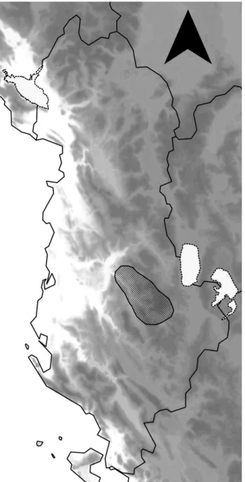
Fig. 1. Map of Albania and the study area (hatched).
Further information in the attribute table has been assigned to each habitat plots (polygons): coordinates, the main communities found in the region and the phytoclimatic belt relevance.
All habitat types and their spatial distribution in the studied watershed area of the Devoll River, which fully correspond to the terms of codes and defi nitions in the Directive 92/43/EEC (Council Directive 92/43/EEC 1992), were mapped using Geographical Information System (GIS). Th e analysis of existing data was concentrated at the 1: 5,000 scale.
Seventeen fi eld trips were undertaken and about 1000 GPS points were reg- istered altogether. Subsequent fi eld work missions were undertaken as a quality control measure to verify map information.
For plant identifi cation Flora Europaea (Tutin et al. 1968–1980, 1993) and Flora of Albania (Paparisto et al. 1988, Qosja et al. 1992, 1996, Vangjeli 2015) were used.
RESULTS
As a result of high biodiversity, the study area supports a wide range of natural and semi-natural habitats, which cover about 73.5% of the study area.
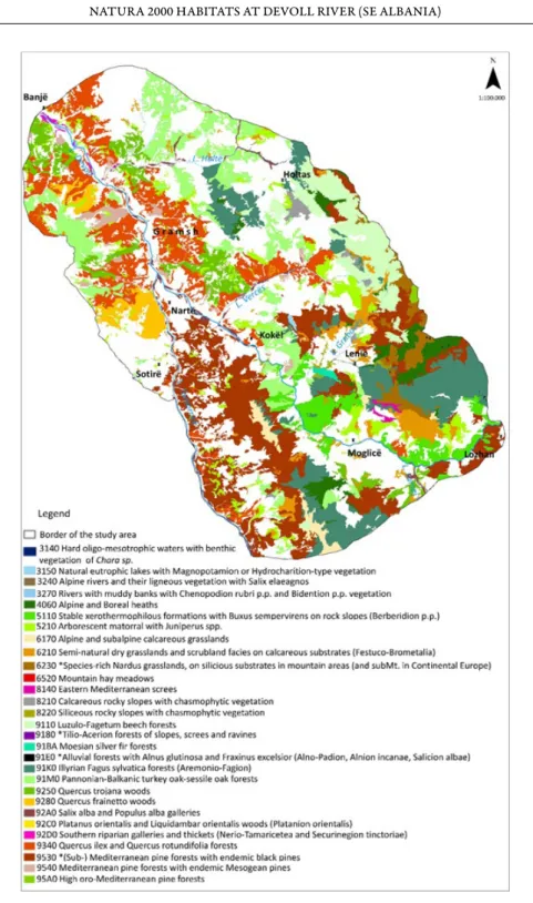
29 habitat types of Annex I of the Habitat Directive (Directive 92/43/EEC) were identifi ed, from which habitats 9530, 9180, 6230 and 91E0 are priority, while the habitat 3240 is reported for the fi rst time in Albania (Fig. 2). Th e most representative habitat is the (Sub-)Mediterranean pine forests with endem- ic black pines (9530). About 22.5% of the study area is covered by habitats 9340, 91M0, 9250, and 9280, which belong to the hierarchical group of thermophil- ous forests and scrub among which the maquis and oak forests are identifi ed.
About 4.1% of the study area is covered by grasslands, belonging to habitats 6170, 6210, 6230, and 6520. From these, around the 36% is covered by the habitat Semi-natural dry grasslands and scrubland facies on calcareous substrates (Festuco-Brometea, 6210).
Based on the diagnostic species present in the beech forests of the study area and at the results of the work of Hoda et al. (2018), we classifi ed these forests in two habitat types: 91K0 Illyrian Fagus sylvatica forests (Aremonio-Fagion) oc- curring at intermediate altitude (1200–1500 m) and 9110 Luzulo-Fagetum beech forests occupying the higher altitudes (1600–1800 m).Th e impact of human ac- tivity is very high through agricultural activity, deforestation for fi rewood collec- tion, grazing, livestock, etc. As a result, about 26.5% of the study area is covered by modifi ed and artifi cial habitats which are not included and classifi ed in the present habitat map. In the Natura 2000 habitats map (Fig. 2) all these areas are marked with white colour.
Fig. 2. Natura 2000 habitats map of the study area.
DISCUSSION
Th e study area is considered as an area of high biodiversity value, which results from the geographic position and high diff erences in altitudes, microcli- mate elements, mountains, edaphic factors and, to some extent, due to the vari- ous forms of traditional use of the forest areas and plants. Th ese are refl ected even in a wide range of natural and semi-natural vegetation types and habitats.
Semi-natural and modifi ed habitats, especially those intensively used for fi re- wood collection and grazing, constitute the majority of the habitats present, while artifi cial habitats represented mostly by pine plantations on eroded slopes only cover small sections of the study area.
Habitat types in the watershed of the middle fl ow of the Devoll River can be easily classifi ed in three fundamental types: 1) strictly aquatic ones that live in the river-bed or lake and water reservoirs, 2) riparian habitats that grow along the river banks, 3) terrestrial habitats. Most of the aquatic fl ora consists of algae and taller plants which are suited for humid environments and sometimes even complete immersion, even if temporary. Aquatic plants depend on a riverine en- vironment, and their existence is infl uenced by many factors. For example, peri- ods of submersion, the aquifer level, the force of the current, the composition of the riverbed, and the transparency of the water all play an important role. Some plants are completely submerged while others root in the riverbed and emerge from the water at various heights. More typical of these vegetation types are the reed beds with Typha angustifolia, Phragmites australis, and Typha minima, which latter is a rare species in Albania.
Riparian vegetation includes shrubs and arboreal species (Salix alba, S. pur- purea, S. elaeagnus, Populus alba, Platanus orientalis, Tamarix parvifl ora, Alnus glutinosa, etc.), which are found in areas between aquatic plants and other plant species, with a total surface about 953 ha (0.9%) in the study area. Riparian veg- etation of the study area is one of the most important vegetation types but even more endangered from the construction of hydropower plant (HPP). In this vegetation type six Natura 2000 habitats were identifi ed, from which 91E0* is a priority habitat. Th e habitat most aff ected by hydropower, the dam of Banja hy- dropower up to the Gramshi town now fully fl ooded, is the gallery with Tamarix parvifl ora (92D0).
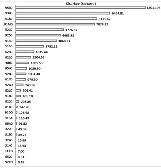
As regards terrestrial habitats of the studied watershed area of the Devoll River, the habitat 9530* covers a huge part of the study area, about 13,012 hec- tares (12.8%). Th e black pine forests are typical above 1000 m but in our study area these formations start from 300 m, oft en mixed with the elements of the Mediterranean maquis (mainly Arbutus unedo) or with the riparian vegetation of the Tomorrica River. In Albania this is not a common situation. Presumably,
the relatively strong infl uence of continental climate from the upper part of the Devoll and Tomorrica Rivers has created favourable conditions for the establish- ment of black pine populations in the area between these two rivers.
Th e habitat types of thermophilous forests occur in the lower part of the study area to about 1000 m above sea level where the Mediterranean climate is dominant. Th is habitat type is mainly represented by semi-natural grasslands, formed as a result of human activity, such as deforestation and abandonment of agricultural lands.
Habitat 8220, the chasmophytic vegetation of serpentine and siliceous sub- strates has an outstanding conservational value. Th is habitat type represents one of the most important habitat types related to important species, i.e. endemic
Fig. 3. Th e surface area of the mapped habitat types.
and subendemic species. Fanelli et al. (2018) described a new alliance from the vegetation of silicon-serpentine substrate in our study area and the Shebenik- Jablanice National Park, named Festucopsion serpentine (Halacsyetalia sendt- neri). Due to its special characteristics, Fanelli et al. (2018) have proposed to include this habitat to the Annex I of the Habitat Directive.
* * *
Összefoglaló: A szerzők Albánia középső részén, a Devoll vízgyűjtőjének 1017 km2-es terü- letén végezték el az ott található Natura 2000 élőhelyek tipizálását és térképezését. A vizsgált te- rületen belül az ország legnagyobb részéhez képest kifejezettebb kontinentális hatás érvényesül, az alacsonyabb régiókban viszont tipikus mediterrán klíma és növényzet a jellemző. A térképezéshez georeferált légi felvételeket és topológiai alaptérképeket használtak fel, és 17 terepnap során mint- egy 1000 ponton rögzítették az ott található és a környező vegetáció paramétereit.
A munka során összesen 29 közösségi jelentőségű Natura 2000 élőhely előfordulását sikerült kimutatni a területről. Legjelentősebb kiterjedésben a 9530-as kódú Mediterrán (szubmediterrán) fenyőerdők endemikus feketefenyővel találhatók meg, emellett jelentős a Magyaltölgy (Quercus ilex) és kereklevelűtölgy (Quercus rotundifolia)-erdők (9340), a Pannon cseres-tölgyesek (91M0), a Macedón- tölgy (Quercus trojana)-erdők (9250) és a Magyar tölgyesek (Quercus frainetto) (9280) területaránya.
A bükkösöket két típus, az Illír bükk (Fagus sylvatica)-erdők (Aremonio-Fagion) (91K0) és a Mészke- rülő bükkösök (Luzulo-Fagetum) (9110) képviselik. A Magashegységi folyók és fás szárú vegetációjuk parti fűzzel (Salix elaeagnos) (3240) élőhelyet most először jelzik Albánia területéről. A gyepek ará- nya alárendeltebb a vizsgált területen, 4,1%-ot borítanak. Közülük leggyakoribbak a Meszes alap- kőzetű féltermészetes száraz gyepek és cserjésedett változataik (Festuco-Brometalia) (6210), a Hava- si és alhavasi mészkedvelő gyepek (6170), a Meszes alapkőzetű féltermészetes száraz gyepek és cserjése- dett változataik (Festuco-Brometalia) (6210), a Fajgazdag Nardus-gyepek szilikátos alapkőzetű hegy- vidéki területeken és kontinentális európai területek domb- és hegyvidékein (6230) és a Hegyi kaszáló- rétek (6520).
REFERENCES
Council Directive 92/43/EEC (1992): On the conservation of natural habitats and of wild fauna and fl ora. – http://eur-lex.europa.eu/le gal
Devillers P., Devillers-Terschuren J. & Ledant J. P. (1991): CORINE biotopes manual.
Habitats of the European Community. Part 2. – Offi ce for Offi cial Publications of the European Communities, Luxembourg, 300 pp.
Fanelli G., Gjeta E., Mahmutaj E., Mullaj A., Salvatori F. & De Sanctis M. (2018): Th e ophiolitic communities of Shebenik Jablanice National Park (Albania). – Rendiconti Lincei.
Scienze Fisiche e Naturali 29(2): 309–328. https://doi.org/10.1007/s12210-018-0694-7 Hoda P., De Sanctis M., Fanelli G., Farcomeni A., Kalajnxhi A., Mahmutaj E., Mer-
sinllari M. & Attorre F. (2018): Modelling the Carpino–Fagetea communities in Albania.
– Abstract, 27th Congress of the European Vegetation Survey, 23–26 May. Poland
Kabo M. (1990, 1991): Gjeografi a Fizike e Shqipërisë Vol. 1–2. – Akademia e Shkencave e RPS të Shqipërisë, Qendra e Studimeve Gjeografi ke, Tirana, 551 pp.
Meço M., Mullaj A. & Barina Z. (2018a): Th e vascular fl ora of the Valamara mountain range (SE Albania), with three new records for the Albanian fl ora. – Flora Mediterranea 28: 5–20.
https://doi.org/10.7320/fl medit28.005
Meço M. & Mullaj A. (2018b): Assessing the medicinal and aromatic plants in watershed of the middle section of Devoll River. – 10th Conference on Medicinal and Aromatic Plants of Southeast European Countries. Split, Croatia, 20–22 May 2018
Norconsult (2010): Devoll Hydropower Project. – Development Phase (ESIA Report), Tiranë Paparisto K., Demiri M., Mitrushi I. & Qosja Xh. (1988): Flora e Shqiperise. Vol. 1. – Acad.
Sci. Albania, Tirana
Qosja Xh., Paparisto K., Demiri M. & Vangjeli J. (1992): Flora e Shqiperise. Vol. 2. – Acad.
Sci. Albania, Tirana
Qosja Xh., Paparisto K., Vangjeli J., Ruci B. & Mullaj A. (1996): Flora e Shqiperise. Vol. 3. – Acad. Sci. Albania, Tirana
Tutin T. G., Burges N. A., Chater A. O., Edmondson J. R., Heywood V. H., Moore D. M., Valentine D. H., Walters S. M. & Webb D. A. (eds) (1993): Flora Europaea, 2nd ed., Vol.
1. – Cambridge University Press, Cambridge
Tutin T. G., Heywood V. H., Burges N. A., Moore D. M., Valentine D. H., Walters S. M.
& Webb D. A. (eds) (1968–1980): Flora Europaea, Vol. 2–5. – Cambridge University Press, Cambridge
Vangjeli J. (2015): Excursion Flora of Albania. – Oberreifenberg, Koeltz Scientifi c Books, 661 pp.
(submitted: 23.11.2018, accepted: 30.11.2018)