University of West Hungary
Thesis of PhD dissertation
SURVEY ON THE BOTANICAL STATE AND VEGETATION CHANGE OF THE MIRES OF
ALCSÍK BASIN
Szilárd Kerekes
Sopron – Csíkszereda 2010
UNIVERSITY OF WEST HUNGARY
Kitaibel Pál Doctoral School of Environmental Sciences
Bioenvironmental Science Program
Scientific tutor: Dr. habil. Király Botond Gergely associate professor of university
INTRODUCTION
Romania is poor in mires compared to its Central European neighbours. Prior to water regulation works only 0.03 % of its surface was covered by mires.
The mire region of Csík Basin has an outstanding position among the mire areas of Romania because it is extensive and rich in glacial relict plant species.
Due to human influences, mires cover only 0.01 % of the country at present and the water regulation works ruined the major part of the Csík mire region as well.
As the natural areas became more appreciated, the remaining mires were declared as protected. However, this act was not followed by regular conservation management and the state of the water deficient mires is continuously declining.
There are botanical surveys available on Csík Basin, however, most of these were compiled before the water regulation works. In the following period only few research were made discussing the human influences on the botany of the mires.
AIMS OF THE SURVEY
The survey on former changes and their results that determine the current state of the mires lead us to the
knowledge on the on-going processes in the area and through this its active and effective conservation.
Because of this, we considered the most important to give answers for the following questions:
• What could have been the former state of the mires of Csík Basin?
• What kind of anthropogenic effects affected these mires?
• How did these effects influence the vegetation of the mires?
• What is the current state of these mires?
• What factors threaten the mires of Csík Basin today?
• What suggestions can be made for conservation regarding the current state and former changes of the vegetation?
SURVEY METHODS
The surveyed area is situated in Alcsík Basin (part of the Eastern Carpathians) at the altitude of 641-650 m. On the flysch base the sediment layer made up of andesite pyroclastics is covered by black meadow, gley, peat, humic alluvial and bog soils. The watertable can be found at 0-1.0 m depth. The climate of the area is sub-alpine basin climate, with annual mean temperature 5.9 °C and average annual precipitation 567 mm.
We chose Borsáros mire and Belső-Égés fen complex for research sites. The reason for this was that these mires are known relatively for long and we have numerous data on them, however, their summarizing elaboration is still missing.
Another reason for the selection was that these are still in a comparatively good state.
Borsáros minerogenous mineral water flush is situated in the area of Csíkszentkirály settlement, on the right floodplain of Olt River. It consists of two isolated parts: Vízkert (2.1 ha) and Omlásalja mires (0.4 ha).
Belső-Égés minerogenous, topogenous fen complex is located west of Csíkverebes village, on the right floodplain of Olt River. Its area is 6.2 ha.
For the landscape history research of the area studies and maps (First Military Mapping Survey, Austrian-Hungarian military map 1894, map of Borsáros 1953 by KRISTÓ, tourist map 1998), former descriptions and coenologic relevés of habitats, photos and memoirs were used.
Flora changes were followed by spectral analysis, in which the species list compiled by former researchers was compared with the present flora of the mires. The changes were evaluated according to the ecological indexes, life-form, flora element and coenosystematic classification of SANDA et al. (1983) as
well as the social behaviour types and rarity indexes of BORHIDI (1993). As the former frequency data were absent, we had to rely only on the comparison of the proportions of each category.
The survey on the actual vegetation was carried out during elaborate field trips between 2004-2009.
For the habitat descriptions of the mires under significant anthropogenic effect and characterized by various degradation rates and succession states an actual vegetation map was compiled. For vegetation mapping 1:5000 scale cadastral maps, 1:25000 scale military maps and aerial photos published by Google Earth were used.
During mapping local habitat categories based on physiognomic-habitat criteria were separated modelling the General National Habitat Classification System (Á-NÉR) (BÖLÖNI et al. 2007). The borderlines of the vegetation units were designated during the elaborate field trips and were documented by GPS device. The vegetation maps were drawn by Digiterra Map geoinformatics software.
The field sampling of the vegetation was implemented by making coenologic relevés and habitat descriptions. My purposes were to sample in a way that makes the methods and sampling repeatable as well as the objective designation of the
sample sites. 40 coenologic relevés and descriptions were made. In additional 120 incomplete relevés only the descriptions were used.
RESULTS
Results of the landscape history survey
In my study, the human activities, which crucially determined the present state of the mires of Csík Basin were summarized. These are the following:
In the 13th century when the Székely settled down the basin was almost uninhabited and a rather wet, inaccessible area. Its bottom was covered by mires, birch and spruce swamps.
The Székely inhabited the river terraces at first, cleared the forests in the basin as well as led the water of the mires and swamps into the riverbed of Olt. They turned the dried up areas into pastures and ploughlands and from the 15th century they moved near the riverbed of Olt already suitable to settle down in.
From the beginning of the 18th century, following the Tartar invasion and with the appreciation of the value of wood, in the neighbourhood of the settlements forest felling continued at a high rate.
In the second half of the 19th century there was a 2.400 ha large “swampy, boggy meadow land” along Olt River and an approx. same size area was flooded by Olt every year.
To stop the floods the mass of the water was diverted to a new riverbed in 1891-1892. The river regulation decreased the water-dominated area to 1.600 ha.
Between 1975-1986 a new great river regulation and drainage works were carried out in the basin.
Analysing the fieldwork and aerial photos it revealed that there are 11 significant mires of approx. 65 ha size present in the region today and these are situated exclusively in the area of Alcsík Basin.
Their natural succession processes were substantially disturbed by water regulation and powerful degradation processes launched. The glacial relicts became scarce or in places disappeared completely.
The fieldwork proved that the conservation measures without revitalization interventions (declaration of protection status, designation of administrative organizations and restriction of traditional land use methods) have not improved the state of the mires, but have provided undisturbed succession and degradation processes.
Survey results on the change of vegetation and flora Borsáros mire
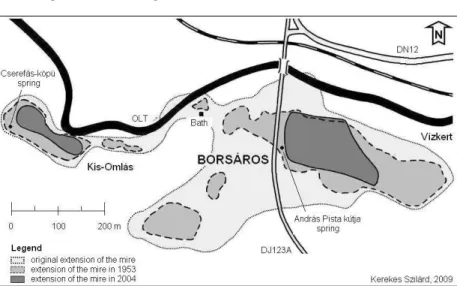
In the first half of the 20th century, after the drainage works the peat moss mire began to shrink and became fragmented (Fig. 1.).
Fig. 1: The changes of the extension of Borsáros mire
For the 1940s Molinia meadows with scattered willow and birch bushes turning into peat moss mires became the characteristic habitat of the mire.
For the 1980s in Vízkert part, which is poor in water and not regularly managed the Molinia meadow with Salix repens subsp. rosmarinifolia was surrounded by partly continuous
grey willow scrub, grey willow scrub with alder and grey willow scrub with birch habitats.
In Omlásalja part of good water supply, which is regularly mown, peat moss transition mire, tussock sedge communities, rich fens, grey willow scrub with alder and reedbed were formed. In the 2000s when the mowing ceased, tall herb communities and reedbed began to expand.
The evaluation indicated the significant changes in the flora of the mires (KEREKES 2007):
The proportion of boreal and circumpolar flora elements, the hemicryptophyte, microterm, hydrophyte, mesohydrophyte, acidocline, acidophile species, species occupying nutrient poor habitats, preferring abundant sunlight, specialists and generalists and species to be protected decreased.
At the same time, the proportion of European, Eurasian, cosmopolitan flora elements, species characteristic of Molinio- Arrhenatheretea, Querco-Fagetea and Phragmiti- Magnocaricetea classes, arboreal, mesotherm, mesophyte, neutrophil species and those of mesotrophic-hypertrophic habitats, natural weed species and ruderal competitors increased.
We concluded that the ratio of species referring to natural state (72 %) and to be protected (20 %) is still high, however,
shows decreasing tendency (KEREKES 2008). The proportion of alien flora elements remained negligible.
Belső-Égés fen complex
At the beginning of the 20th century, the mire was occupied by tall sedge and reedbed communities, Carex nigra fens and tussocks, willow and alder bushes. The smaller or larger open water surfaces were covered by communities of floating island character.
After the water regulation works in 1975-1986 the grassland management was halted and as a consequence, reedbeds occupied the edge areas. In the inner part of the mire grey willow scrub formed. The extension of transition fens and tall herb communities increased and on the other hand, the cover of rich fens decreased.
From the results of the spectral analysis of the flora, it revealed that in the fen complex the number of Eurasian flora elements, arboreal and annual species, species characteristic of Molinio-Arrhenatheretea and Phragmiti-Magnocaricetea classes, mesophyte, xeromesophyte and neutrophil species, species of eutrophic habitats as well as disturbance-resistant indigenous species increased.
The ratio of hemicryptophyte, hydatophyte and helophyte, mesohydrophyte and hydrophyte species decreased. The
number of species characteristic of natural habitats slightly decreased, however, still remained high (75 %). The ratio of species to be protected is significantly high (29 %).
The share of circumpolar and boreal (22 %) as well as alien species (1 %) didn’t change considerably.
Results of vegetation mapping and coenologic survey More important vegetation units of the surveyed mires
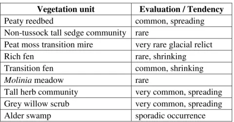
In the survey, we concluded that in the studied mires there are nine vegetation units that are regularly repeated and/or of significant extension (Tab. 1.).
Tab. 1.: Summarizing table of the mire vegetation units Vegetation unit Evaluation / Tendency
Peaty reedbed common, spreading
Non-tussock tall sedge community rare
Peat moss transition mire very rare glacial relict
Rich fen rare, shrinking
Transition fen common, shrinking
Molinia meadow rare
Tall herb community very common, spreading Grey willow scrub very common, spreading
Alder swamp sporadic occurrence
The succession state between a rich fen and Molinia meadow is called transition fen.
Succession relationship system of the described vegetation units
Based on the evaluation of historical sources, floristic data and field experiences the following succession relationship system is assumed between the listed vegetation units (Fig. 2.):
With the change of water conditions, the peat moss transition mires are replaced by rich fens or Molinia meadows.
In the case of rich fens, the succession can lead towards transition fens, Molinia meadows, reedbeds, tall herb communities or grey willow scrubs.
If the proper water supply and moderate grassland use are lacking, the transition fens can turn into Molinia meadows, swamps, reedbeds, tall herb communities, grey willow scrubs or birch swamps. The Molinia meadows are replaced by grey willow scrubs.
The non-tussock tall sedge communities are substituted by tall herb communities and Molinia meadows. The tall herb communities transform into grey willow scrubs or can turn into ruderal tall herb communities if their habitat dries out.
The forestation of grey willow scrubs leads to the development of alder swamps. If the habitat conditions change, the alder swamps and birch swamps are likely to turn into alder-willow gallery forests.
Fig. 2: Draft relationship system of the more important vegetation units of the surveyed mires
Legend:
→ – direction of succession, - - → – questionable process, ↔ – formation of natural transitions on the habitat borders
The actual vegetation of Vízkert mire
On the basis of field trips and species lists the actual vegetation map of the mire was compiled. It shows that approx.
three quarter of the mire is covered by arboreal and one quarter of it is covered by non-arboreal mire vegetation (Fig. 3.).
Fig. 3.: The actual vegetation map of Vízkert mire
Legend road
mineral water spring draining ditch
non-tussock tall sedge community
transition fen tall herb community
meadowsweet stand grey willow scrub birch-grey willow scrub alder-grey willow scrub alder swamp (gallery forest
type)
humid arboreal vegetation
Based on the estimation of the population sizes of the protected and to be protected plant species, we concluded that from the conservation point of view fens are the most valuable parts of Vízkert mire. Their outstanding values: Angelica palustris, Betula humilis, Ligularia sibirica.
The actual vegetation of Omlásalja mire
The elaborated vegetation map shows that on approx. the four fifth of the mire non-arboreal vegetation (reedbed, non- tussock tall sedge community, peat moss transition mire, rich fens and transition fens, tall herb community) and on one fifth alder-grey willow scrub can be found.
The field survey proved that the peat moss transition mire, unique for Csík Basin is the last refuge of the original mineral water flush vegetation (especially Sphagnum magellanicum, Saxifraga hirculus, Drosera anglica).
Based on the survey, it revealed that the majority of the rare plant species is seriously endangered in both mires. They find their living conditions in shrinking areas and their isolated populations have continuously decreasing numbers.
The actual vegetation of Belső-Égés fen complex
On the first actual vegetation map of the fen complex the extensions of the reedbed, non-tussock tall sedge community, calcareous rich fen, transition fens, Molinia meadow, tall herb
communities, grey willow scrubs, alder-grey willow scrubs and the developing alder swamp were documented.
We concluded that the reedbed occupied more than the half of the fen complex. Most of the precious plant species populations (Primula farinosa, Lysimachia thyrsiflora, Polemonium coeruleum etc.) have low individual numbers and threatened by vegetation dynamics processes.
SUGGESTIONS FOR CONSERVATION
In their present state, the mires of Csík Basin need strict protection, rehabilitation as well as management. Without these, the mire area is occupied by tall herb communities, reedbeds, willow and alder swamps and as a result, the habitat and species diversity of the mires seriously decreases.
Through the interventions, we aim to restart the peat forming processes and to secure the optimal mosaic-like landscape structure and succession state for successful habitat conservation.
• The ecological water demand of the mires can be provided by halting the consumption of the mineral water feeding the mire and the industrial water withdrawal (Vízkert), the construction of a water retain object (Omlásalja) and the regular cleaning of the railway culvert (Belső-Égés).
• The bank destruction of Olt River has to be stopped by planting willow trees and depositing gravel piles (Omlásalja).
• At the mire edges the present scrubs, wooded swamps, tall herb communities and reedbeds have to be preserved as buffer zones. We have to let the forests and reedbeds settle in the treeless edge areas (Omlás-alja, Belső-Égés), especially where the mires border on ploughlands.
• During winter the grey willow scrubs separating the fens (Vízkert, Belső-Égés) as well as the shrubs from the peat moss transition mire, from tall sedge communities and fens have to be manually removed.
• The tall sedge communities and fens have to be conserved by manual mowing at the end of the summer.
• In the swamps surrounding the mires motorized mowing can take place two or three times a year.
• With the popularization of the natural values of the mires, the attitude towards this habitat type change and the need of its conservation can be supported by local people.
NEW SCIENTIFIC RESULTS
1. A landscape and research history overview was given on the mires of Csík Basin.
2. The major changes, which took place between 1929-2009 in the size, vegetation and flora of the mires were described.
3. The more important vegetation units of Borsáros mire and Belső-Égés fen complex were characterized.
4. The succession relationship system of these vegetation units was drafted.
5. The actual vegetation map of Borsáros mire and Belső- Égés fen complex were elaborated.
6. Formerly not published plant species were reported from the surveyed mires.
7. The estimation of population sizes of protected and to be protected plant species was carried out in the surveyed mires.
8. We drew attention on the threatening factors of the mires of Csík Basin.
9. Conservation management suggestions were made to achieve the successful protection of the natural values of the mires.
LIST OF PUBLICATIONS RELATED TO DISSERTATION
In conference papers:
KEREKES SZ. (2006): A csíkszentkirályi Borsáros-láp (Alcsíki-medence, Erdély) állapotfelmérése. In: Aktuális flóra- és vegetációkutatás a Kárpát-medencében VII.
(Debrecen, 2006. február 24-26.)
In scientific journals in Hungarian language:
KEREKES SZ. (2007): A csíkszentkirályi Borsáros-láp flóraváltozásainak ökológiai és természetvédelmi értékelése – A Csíki Székely Múzeum Évkönyve. Humán- és Természettudományok 2006: 389-411.
KEREKES SZ. (2008): A mocsári kőtörőfű (Saxifraga hirculus L.) előfordulása Romániában – A Csíki Székely Múzeum Évkönyve. Humán- és Természettudományok 2007-2008:
237-246.
LIST OF PUBLICATIONS NOT CLOSELY RELATED TO THE DISSERTATION
In scientific journals in Hungarian language:
KEREKES SZ. (2005): Természetkutatás és -védelem a lakóhely környékén – Magiszter Pedagógusok szakmai- módszertani folyóirata III (3): 28-39.
KIRÁLY G. – BARANYAI-NAGY A. – KEREKES SZ. – KIRÁLY A. –KORDA M. (2009): Kiegészítések a magyar adventív-flóra ismeretéhez IV. – Flora Pannonica 7: 3-31.
Lecture notes, textbooks:
KEREKES SZ. – BARTHA D. (2006): Természetismeret Tankönyv a IV. osztály számára – T3 Kiadó, Sepsiszentgyörgy, 112 pp.
KEREKES SZ. – BARTHA D. (2006): Természetismeret Munkafüzet a IV. osztály számára – T3 Kiadó, Sepsiszentgyörgy, 84 pp.