E-JOURNAL • 2020 AUTUMN
HUNGARIAN ARCHAEOLOGY
www.hungarianarchaeology.hu
PARADIGM SHIFT IN THE RESEARCH INTO ROMAN ROADS?
Possibilities of site diagnostics in road research in Roman Pannonia
András Bödôcs1
Hungarian Archaeology Vol. 9 (2020), Issue 3, pp. 1–12. doi: https:// doi.org/ 10.36338/ ha.2020.3.2
During the ca. 500 years of the Roman Empire, road construction and maintenance was viewed as a pri- ority, but it also offered a perfect means of propaganda. Today, the traces of these activities are visible in many places; inscriptions on Roman milestones (miliarum) and on other constructions proudly present these extraordinary achievements, which were accomplished, in most cases, by military pioneer troops.
“MILESTONES”
The search for Roman roads also takes note of anecdotal discoveries, one of the most entertaining of which is undoubtedly the story a French Foreign Legion unit and its commander, presumably the well-known General Armand-Jacques Leroy de Saint-Arnaud. In 1850 in North Africa, he and his troops broke through a previously impassable gorge in the Atlas Mountains (probably the Kanga Pass). However, his joy to be the first to pass here in history ended when he saw the inscription of the Third Augustan Legion (from 145 A.D.?) on one of the rock walls, which informed posterity that the legionaries repaired the road here (or, according to other opinions, they built it; see von Hagen, 1967; Ürögdi, 1979; glynn-Jones, 1996, 121).
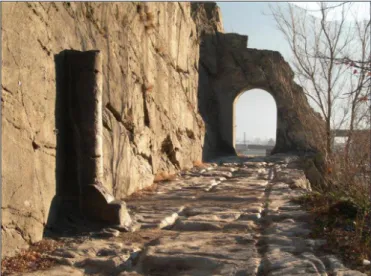
Encountering the inscription of the Tabula Traiana or the Roman road to the Danube for the first time must have been a similar experience. Unfortunately, research in Pannonia has not been able to find anything comparable. The reason for this was explained by Gábor Finály in 1903: “Here, transportation is possible not only on the natural transport line that runs along the banks of the Danube, but almost everywhere, as it is the nature of the hilly landscape” (Finály, 1903, 64). As a consequence, there are no spectacular moun- tain roadways that have been in use for centuries, or rock-cut passages where Roman pioneers could have demonstrated their expertise, such as the “tunnel” of the Donnas rock road (Fig. 1), the inscribed “tunnel” at Pierre Pertuis in Switzerland (CIL XIII, 5166), or the rock-cut passage of Mont de Lans in France along the Roman road to Bons (CHevallier, 1997; Moreno
gallo, 2004), just to name a few examples. Routes between Roman settlements known from ancient sources could have remained intact during the medi- eval period and could be found almost anywhere in the well-accessible Pannonian terrain. No wonder that for more than 150 years the Hungarian archae- ology journals urged researchers to map Pannonia’s former Roman road network. Flóris Rómer drew attention to this issue already in 1866 (róMer, 1866, 83): “Defining the course of Roman roads is highly necessary in order to describe our old land”. Still, more than 100 years later, Endre Tóth expressed this need in a remarkably similar way (TóTH, 1975, 275).
In the decade that followed, Roman road research made more progress than in the century before, thanks to the reinterpretation of archival maps and their comparative analysis based on modern archae-
1 Institute of Archaeology, Eötvös Loránd University. E-mail: bodocs.andras@btk.elte.hu
Fig. 1. Roman road cut into rock, with a milestone and a gate. Donnas, Aosta, Italy(source: http://www.crdl.scuole.
vda.it/images/civilisation/paysage.pdf)
ological field research (TóTH, 1977; CserMényi & TóTH, 1979–1980). Studies also took a different – above ground – perspective, due to the revolutionary approach of aerial archaeology that facilitated a break- through in road research (visy 1978; visy 1980). One may say that these were the enlightening moments of research into roads in Roman Pannonia, which showed that a systematic mapping of the road network was possible in spite of a long period of failed attempts. Now, a few decades later, we are at an interesting turn- ing point again, exploring the possibilities of archaeological GIS applications and modern site diagnostics.
ROMAN ROAD PLANNING
The Roman road network is fundamentally different from the earlier, prehistoric road network. The most striking distinction is its planning and magnitude – almost 100,000 km of roads were built on the territory of the empire (TóTH, 2005). Road construction was probably not a Roman invention; according to Isidorus of Spain (Isid., Etim. 15, 16, 6), it was popular knowledge that Romans had learnt the technique of construct- ing stone-paved roads from the Phoenicians (Carthaginians), who had to create better quality roads as they lived in semi-desert areas (sMiTH 1875, 1191–1195). Yet, the quality of the road network that often forms the basis of modern-day transport routes is clearly an achievement of Roman engineering. Hugh Davies considers three main aspects as a precondition for the creation of the Roman road network (davies 2002, 16):1. The knowledge of and adaptation to the topographic environment between the points of departure
and arrival;
2. The crucial role of transport, especially the transport of goods;
3. Engineering knowledge that enables a population to overcome natural barriers and transform their topographical environment.
Engineering, including land surveys, is hardly imaginable without prior planning. For planning, the use of blueprints is essential, and as blueprints are based on geographic knowledge, surveys and topographic maps are required as well. We know about a wide variety of professional terms used in engineering, as well as many design and construction tools that were presumably used in road building (Bödőcs, 2008). How- ever, at present, there is little research on how, and along what principles the routes were defined, since we do not have a “manual” that would describe in detail the methods of road construction in a manner similar to Vitruvius’ work on architecture. In addition to archaeological data, Vitruvius’ writings (Vitr. 5, 1; Ten books on architecture) and Statius’s poem on the construction of the via Domitia (Stat. Silv., 4, 3), provide information about technological practices. However, these sources only reveal the methods of road building but fail to discuss why a road was built at a given location. In addition, writings on legislation mention a few details, such as how wide the roads should be. There is only one group of sources that reveals informa- tion about the peculiarities of planning and design:
a special collection written mostly by surveyors, called Corpus Agrimensorum Romanorum (CAR).
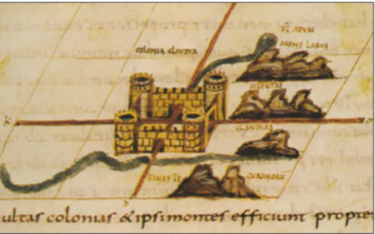
These writings discuss how the road network sys- tem was established, and how it affected the dirt roads bordering the plots in the strictly orthogonal estate system; the latter was developed during the years of the late Republic and the early Empire and was implemented when veterans were allotted land (Fig. 2). Road parameters mentioned in legal texts also most often concern such roads, i.e. parts of the same rural dirt road network, created in the territory of the coloniae or in other rural areas.
Why is the rural dirt road system so important for the construction of impressive long-distance roads,
Fig. 2. Representation of the centuriatio in a 9th-century miniature from the so-called Palatinus 1564 manuscript:
the topography and land allotment around Colonia Clavdia (probably Aventicum)
András Bödőcs • Paradigm Shift in the Research into Roman Roads?
3 HUNGARIAN ARCHAEOLOGY E-JOURNAL • 2020 Autumn
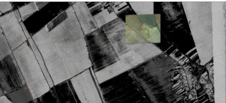
found in several places throughout the empire? Ancient surveyors already emphasised that the centuriatio, i.e., the land measurement and division system, should adapt to the conditions of the landscape, which may be dominated by a coastline, a bay, a river, or an important route. Around Corinth, for example, roads were planned in relation to the coastline and to each other (roMano, 2006). In the Po plain, along the via Aemilia, a number of orthogonal plots were documented, which followed the line of the main road. Another example is the area around Pula (in Istria), where the rectangular cultivation system based on Roman design still dominates today’s landscape and can be perceived using freely available remote sensing data (Fig. 3).
In landscapes with a hardly travelable terrain, Roman pioneers must have looked for old pathways that had been in use for centuries, which could be refurbished and made more accessible; in open land- scapes, on the other hand, it was possible for them to design new routes freely. Upon analysing the Roman roads mapped in Britain, Peterson came to the conclusion that their routes show mathematical, (coordinate) geometric connections with the centuriatio land division system (PeTerson, 2014). The Roman centuriatio, created by the division of land, was a gigantic grid of coordinates, which also served as a reference during the construction of the major military and trade routes. This suggests that following the occupation of a territory, in-depth topographical studies and surveys were carried out. Entertaining this hypothesis may facilitate the discovery of Roman roads in Pannonia, similarly to Britain, where roads could be constructed just about anywhere due to the landscape’s topographical character.
REINTERPRETING A ROMAN ROAD IN PANNONIA
During cadastral and topographic surveys carried out in Hungary in the 19th century, Roman road tracks or their hypothetical traces were often recorded by the surveyors. Based on these data, Endre Tóth was able to survey and document in the 1970s one of the longest Roman road sections in Hungary, between pres- ent-day Szombathely and Sárvár (Fig. 4). This road was marked as “Alte Römerstrasse” [old Roman road]
on the map of the Second Military Survey, and it also appears as a Roman route on earlier cadastral maps (TóTH, 1977). Archaeological excavations identified this road in the early 2000s (Kiss, 2007; anderKó, 2009). Drawing on information from the Itinerarium Antoniniana (Itin. Anton. 262, 9–263, 2), Endre Tóth identified this road as a section of the Roman route between Savaria and Brigetio, and since then it has been acknowledged by scholarship as such.
Archival and remote sensing data, the results of more recent excavations, and the GIS analysis of these datasets opened new possibilities for the interpretation of this road. The large-scale excavations that started in the late 1990s brought to light several small Roman dirt road sections, which were successfully inte-
Fig. 3. Google Earth’s satellite image of the environs of Pula in Istria (Colonia Iulia Pola Pollentia). The areas encompassed by the rectangularly arranged present-day roads correspond to 2×2 centuriae (ca. 1×1.4 km)
grated into a coherent orthogonal system by the means of GIS tools (Bödőcs, 2008; 2014). It became clear that these roads were elements of a large cadastral system, the above-mentioned centuriatio, created after the Romans founded Savaria. After identifying aerial archaeological phenomena with the help of computer models and upon integrating them with excavation data, it can be stated that the land division system cre- ated around Savaria corresponds in all respects to the ideal construction schemes proposed by the authors of the above-mentioned CAR. In the past, attempts were made to identify this land division system (MóCsy, 1965; gugl, doneus & doneus, 2008), but archaeological research failed to validate these models. Our recent reconstruction also demonstrated that, in contrast to areas that once belonged to the Roman Empire, such as Tunisia, Northern Italy, and, especially, France – where similar results were achieved using car- tographic analysis and aerial photo filtering (e.g. filtrage optique method: CHarrauT & Favory, 1993;
gugl, 2005; Bödőcs, 2011) –, the current topographic conditions of Hungary cannot be efficiently studied with these methods, because our present-day landscape has preserved fewer traces of Roman activity than the regions mentioned above. The position of the Roman roads shows that the Roman land division system can no longer be unambiguously detected in the orientation of today’s landscape elements, as is the case in some regions of Western Europe (Bödőcs, 2009). However, the theoretical model, created on the basis of the archaeological data, made it possible to incorporate a considerable amount of information provided by remote sensing (Fig. 5) (Bödőcs, 2008; 2011; 2013; 2014; 2015).
Fig. 4. On the map of the Second Military Survey (to the right), there is a Roman road near the village of Bögöt. The track of a past road is clearly visible on the satellite image, in line with the straight modern roadway. The gravel embankment is not
visible anymore on the terrain, as it was in 1977 according to Endre Tóth’s publication (TóTh, 1977)
Fig. 5. This 1986 photo from the aerial photo archive of the Institute of Military History shows a complete centuria in the area between the villages of Kőszegpaty and Vasasszonyfa: phenomena (dark stripes) that follow the lines of the centuriatio model
(gray lines). Although its north-eastern corner was not visible in the original image, it could be completed by using Google Earth’s data
András Bödőcs • Paradigm Shift in the Research into Roman Roads?
5 HUNGARIAN ARCHAEOLOGY E-JOURNAL • 2020 Autumn
The Roman road between Szombathely and Sárvár, and the photo mosaic of the area of Felsőcsatár west of Szom- bathely, assembled from several aerial photographs, fit into this scheme (Bödőcs, 2013).
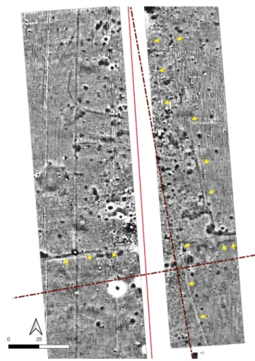
In the photo mosaic (Fig. 6), the line of an east-west road is clearly visible, and in some places, it is crossed by perpen- dicular features, probably other roads (limites). This road is of special importance because its track is the continuation of the Roman road between Szombathely and Sárvár, as published by Endre Tóth. Upon examining the images, we selected an area and conducted a geophysical (magnetometer) survey.
The aim was to prove that the feature seen in the aerial pho- tos can indeed be interpreted as part of the centuriatio model and as the intersection of Roman roads and ditches that once bordered landed properties.
The east-west oriented roadway, its ditches, as well as the intersection of the roads and ditches that marked the bound- aries of plots (centuriae) are clearly visible in the composite image (Fig. 7). At the time of its construction, the primary function of the Roman road between present-day Felsőcsatár and Sárvár was to serve as the east-west axis (decumanus max- imus) of the veterans’ estate system in the territory of Savaria.
The question may arise as to whether this road already existed in the time of the Roman estate system development; was the orthogonal system oriented according to a pre-existing path, as the sources mention, or was it newly established? Was this
Fig. 7. Anomalies seen on the magnetometer survey at Felsőcsatár, hypothetically identified as a crossing
of roads. The road (B) running between the ditches of the east-west oriented decumanus maximus, and the bordering ditches of the centuriae (A) are clearly
visible. The survey was made by G. Márkus Fig. 6. A mosaic of photos from various periods and sources, juxtaposed to the centuriatio model (marked by the yellow gridlines).
Note the east-west oriented road in the bottom of the image (decumanus maximus), and another road or ditch north of it in one centuria’s distance. The arrow in the left bottom corner marks the location where the geophysical survey was conducted
road created in the middle of the 1st century A.D? Do we know about any road in this period which may have served as a reference for orientation?
ORIENTATION – PLANNING – SURVEY
In addition to the decumanus maximus, there was another main axis, the cardo maximus, which was ori- ented perpendicularly, in this case in a N-S direction. This is, more or less, the direction of the prehistoric trade route between the Baltic Sea and the Adriatic, known as the Amber Road, named after the best-known raw material that was traded in that time. After the Roman conquest, this road was rebuilt in a better qual- ity, and some of its identified sections are also known from the maps of military surveys, from aerial and satellite images, and from excavation data. There must have been a road there, running in this centuries-old commercial corridor, when in the 1st century A.D. military establishments and civil settlements started to be founded. However, excavation data suggests that no there is no trace for typical Roman constructions (i. e., embankment-like elevation, rammed and gravelled pavement, sometimes with drainage ditches) here before the mid-1st century A.D., at least in the road sections known to date (MladoniCzKi & soszTariTs, 2009; groH, sedlMayer & zalKa, 2013). However, an already existing road along the corridor of the Amber Road must have been a more important factor in terms of site selection than were the earlier, east-west ori- ented roads. Besides, the cardo maximus, which usually followed a N-S orientation, had a vital importance during planning according to the ancient authors (Hyg. Grom., 14). It is not yet possible to identify where the two main axes intersected, and where the so-called locus gromae or the starting point was, but based on what we know about the layout of the colonia, it should probably be looked for outside the western gate, and not in the city centre (see Fig. 2).
The hypothetical route of the road that left the town in a northern direction follows one of the dirt roads of the centuriatio (the so-called limes actuarius or quintarius) for a considerable distance in the area of Herény (Fig. 8). Although farther down it turns
away from the dirt road and ceases to follow the orientation of the centuriatio, the track still shows some connection with it. A straight sec- tion of the road at Nemescsó intersects the raster formed by the centuria (the spatial units based on regular squares) in a ratio of 1:6, while this ratio is 1:8 in the area of Frankenau (Fig. 9).
Is conscious planning and measuring that followed the Roman surveyors’ rectangular coordinate system perceptible in the con- struction of roads? We learn from the Roman auctors themselves that this land division sys- tem could have been used to record and store information. In addition to recording landown- ers in the area of each centuria, a map of the area was made, in which landscape elements were marked along cadastral data. Such a map, pieced together from marble fragments, was unearthed from the area of ancient Arau- sio, present-day Orange (Piganiol, 1962).
A number of inscriptions report on the road building and surveying activities of the legio III Augusta; these serve as a unique historical source that attracts interest across disciplines
Fig. 8. Known and hypothetical remains of Roman roads in the territory of Savaria (thick red line), and traces of the centuriatio
(thin red line), mapped on the basis of aerial photos, satellite images, and excavation data. Only the so-called quintarius roads
(bordering every fifth centuria) are marked (grid). Black boxes indicate the locations seen in Figs 5, 6, 9, and 11
(edited by A. Bödőcs)
András Bödőcs • Paradigm Shift in the Research into Roman Roads?
7 HUNGARIAN ARCHAEOLOGY E-JOURNAL • 2020 Autumn
(AE 1905, 177; CIL VIII, 10018; 10023). Similar inscriptions are known from the time of Anoninus Pius on the construction of via Septimia (Numidia) (CIL VIII, 2705) and on the land surveys that preceded the limitatio/centuriatio (AE 1905, 185). From these inscriptions we also learn that huge areas were surveyed using a rectangular coordinate system that was also used for mapping (CIL VIII, 22786f). According to the texts, huge distances were covered, hundreds of kms from the centre of the survey (deCraMer 2001;
deCraMer et al., 2003). Such a map could be used in a later border dispute during the re-planning process.
We learn from Vegetius (Veg. Mil. 3, 6) that military commanders had topographical descriptions at their disposal; he writes that the commanders going to war must have had maps that accurately represented the given area, and which, just like an itinerary, provided information on accommodation, watering places, crossings, and stations where horses could be changed. If an area had already been surveyed accurately in an orthogonal system for the division of land, and some parts (the colonial lands) had certainly been mapped, it must have been obvious to use the same system to map the whole province. Sources report that in Pannonia, not only the colonial lands, but other areas were also surveyed with the same method, used for the centuriatio system. Therefore, it may be assumed that reasonably accurate information was available on the topography of the province, similarly to North African surveys. The raster grid used in the land division system could also be used for planning and surveying roadways. Certain bearing angles were thus easily measured. There was no need for sophisticated measuring devices such as diopters, the predecessors of today’s theodolites, to set different angle variants (e.g., approximately 45 ° – 1: 1; 30
° – 4: 7; 10 ° – 1: 6; 7 ° – 1: 8). Roman surveyors had the topographic knowledge and mapping experi- ence that Hugh Davies hypothesised, which enabled them to create consciously designed road systems.
In Vitruvius’ description (Vitr. 9, 7, 1), the gnomon – the tool that was used to define the geographical
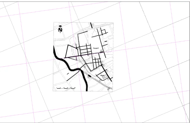
Fig. 9. The reconstruction of the street network of Savaria (after Mladoniczki & SoSzTariTS 2009), and the theoretical blueprint of the centuria-network. In Savaria, there are no axes running through the town center. The symbolic locus gromae, the starting
point is probably somewhere outside the western gate. The rectangular (not square) grid is the hypothetical centuria system according to A. Mócsy (MócSy, 1965)
grid system – provides latitude not as an angle but as the relative proportion of the gnomon’s length and its shadow. These figures (e.g., 5:3 for Alexandria and 7:5 for Rhodes) indeed provide pretty accurate approximations of latitude. Using ratios this way was customary in ancient Roman engineering.
SITE DIAGNOSTICS IN ROAD RESEARCH
In which way does all this help in mapping Roman roads? Today, traditional surface survey and topographic research (e.g. fieldwork) are not the only means for archaeology to localize sites; it is often possible now to use modelling procedures to narrow down the area that is worthwhile to investigate further with various diagnostic tools. Aerial archaeology continues to play an important role in road research; new results are expected especially in the application of unmanned aerial monitoring vehicles (UAV / RPAS), commonly known as drones, in terms of both topographic imagery and infrared surveys. Geophysical surveys con- ducted on contiguous, large surfaces have yielded surprising results in many cases. In terms of verification measurements of the land division model, it is worth revisiting previous surveys, e.g. the test results of known road stations in the area of Nemescsó and Balogunyom. Comparing the land division system to the results from the magnetometer survey conducted at the known road station of the Balogunyom–Ceteháza site, the outcome is impressive (Fig. 10).
Due to the disturbance caused by the excavation, the road station itself remains invisible in the survey, however, it can be localized in the area marked by intense anomalies in the middle of the image. It is inter- esting, however, that on the hypothetical track of the Amber Road there are ditches whose direction and position correspond to the division of the centuriatio (Fig. 11, yellow arrows), and they intersect at right angles at places where the hypothetical blueprint (marked by dotted lines) suggests a boundary between plots. No well-designed Roman roadway (i. e., the Amber Road) is seen on the magnetometer survey, prob- ably because the former Roman road is indeed under the present-day public road. However, it is clear that certain elements of the Roman estate division system can be detected near the road station, and the connec- tion between the building and the centuriatio should also be clarified.
Fig. 10. Sections of the Amber Road between Nemescsó (above) and Frankenau (bottom) that could be identified on Google Earth’s satellite images. The ratio of the road track (white) and the centuria grid (red) is 1:6 and 1:8, respectively (edited by A. Bödőcs)
András Bödőcs • Paradigm Shift in the Research into Roman Roads?
9 HUNGARIAN ARCHAEOLOGY E-JOURNAL • 2020 Autumn
On an 18th century map (TóTH 2005; OSZK TK 1068; Fig. 12), there is a route north of Körmend marked as a Roman road. Unfortunately, the sheet depicts the entire Vas county and is by no means an accurate military topographic map, so this infor- mation cannot be properly processed. Although this road cannot be precisely localized, like the road depicted in the Second Military Survey, its approx- imate direction can be reconstructed, and may sug- gest the presence of either a military road, or the border of the centuria. The extension of this road section is marked on the comprehensive map by a dotted line in the direction of Savaria (Fig. 8). The possible presence of strategic planning, such as the use of the centuriatio as a reference system for road construction, may suggest that this road fits the model of the Roman road observed in the area of Nemescsó and Frankenau. Historical data, when juxtaposed to such models, can help in selecting the part of the research area where site-specific test surveys should be conducted using site diagnostic tools.
EPILOGUE
In general, in Western Hungary there is a correlation between Roman routes and the geometrical elements of the land division system. Therefore, it can be hypothesized that there was a planning strategy behind road constructions, which made it possible to maintain and correct the orientation of routes between destinations, and also took into account topographic features (e.g. river crossings). For further research it is pivotal to map the existing and identifiable traces with high precision and verify the models on large test surfaces.
Thus, future observations can extend the study area from the well-known regions in Western Hungary to areas that are less well understood.
Fig. 12. Detail of map TK 1068 in the National Széchenyi Library, showing Vas county; the caption “Rudera via strata
Rom.” marks the Roman road section
Fig. 11. The magnetometer image of the area around Balogunyom Roman road station, created in a joint effort
of ÖAI and Savaria Museum (after Groh, SedlMayer &
zalka 2013). The white line in the middle is the present-day roadway, and the hypothetical Roman road runs underneath
it. The dashed line marks the hypothetical centuriatio, while the yellow arrows show the ditches that were oriented
according to the centuriatio (edited by A. Bödőcs)
BiBliograPHy
Abbreviations
AE = Année Epigraphique
CIL = Corpus Inscriptionum Latinarum
Anderkó, K. (2009). Mit adtak nekünk a rómaiak? Utakat. [What did the Romans ever gave us? Roads].
https://sirasok.blog.hu/2009/02/02/mit_adtak_nekunk_a_romaiak_2 (Last accessed: 31 August 2020) Bödőcs, A. (2008). A római kori úthálózat térinformatikai vizsgálata a mai Magyarország területén [A geoinformatical analysis of the Roman period road network in present-day Hungary]. PhD Dissertation, Budapest, ELTE.
Bödőcs, A. (2009). A római kori Savaria környéki centuriatio területének vizsgálata térinformatikai eszközökkel [A geoinformatical analysis of the area of the centuriatio around Roman Savaria]. MA Thesis, Budapest University of Technology and Economics.
Bödőcs, A. (2011). Aerial archaeological substantiation of a Roman cadastre system’s predictive model.
The Newsletter of the Aerial Archaeology Research Group 42, 13–25. http://www.univie.ac.at/aarg/php/
cms/AARG-News/aarg-news-42 (Last accessed: 31 August 2020)
Bödőcs, A. (2013). Borders: The problems of the aerial archaeological reserach of a Roman limitatio in Pannonia. In Z. Czajlik & A. Bödőcs (eds.), Aerial archaeology and remote sensing from the Baltic to the Adriatic: selected papers of the Annual Conference of the Aerial Archaeology Research Group, Budapest, 13th–15th September 2012 Budapest, Magyarország (pp. 59–66). Budapest: L’Harmattan Kiadó – ELTE BTK Régészettudományi Intézet.
Bödőcs, A. (2014). Földmérők Savariában. Javaslat a savariai centuriatio újabb elméleti modelljére [Land surveyors in Savaria. Proposing a new theoretical model of the centuriatio in Savaria]. In P. Balázs (ed.), Firkák III: Fiatal Római Koros Kutatók III. konferenciakötet (pp. 361–372). Szombathely: Savaria Múzeum.
Bödőcs, A. (2015). Neuer interpretationsversuch eines altarsteinfragments aus Savaria. In L. Borhy, K.
Tankó & K. Dévai (eds.), Studia Archaeologica Nicolae Szabó LXXV Annos Nato dedicata (pp. 45–56).
Budapest: L’Harmattan Kiadó.
CIL = Corpus Inscriptionum Latinarum
Chevallier, R. (1997). Les Voies Romaines. Paris: Picard.
Cserményi, V. & Tóth, E. (1979–1980). Eine römische Straßenstation und die Straßenstrecke zwischen Salla und Arrabona. Savaria 13–14, 171–203.
Davies, H. (2002). Roads in Roman Britain. Gloucestershire: Shire.
Decramer, L. R. (2001). Auf den Spuren der Geometer der Dritten Legion Augusta. Römische Landvermessungin Nordafrika. Der Vermessungingenieur 3, 194–201.
Decramer, L. R., Hilton, R., Martin, A. & Plas, A. (2003). Centuriations et orientation solaire. Les bornes gromatiques de Tunisie. Communication à la Table ronde du Cercam.
András Bödőcs • Paradigm Shift in the Research into Roman Roads?
11 HUNGARIAN ARCHAEOLOGY E-JOURNAL • 2020 Autumn
Charraut, D. & Favory, F. (1993). De la carte topographique à l’analyse d’images: Méthodologie de l’identification des limitations antiques. Cadastres et occupation dusol. Revue Archéologique de Narbonnaise 26, 19–56.
Finály, G. (1903). Római utak a Dunántúlon [Roman roads in Transdanubia]. Archaeológiai Értesítő 23, 164–173.
Glynn-Jones, A. (1996). Holding Up a Mirror: How Civilizations Decline. London: Imprint Academic.
Groh, S., Sedlmayer, H. & Zalka, V. Cs. (2013). Die Straßenstationen von Nemescsó und Sorokpolány an der Bernsteinstraße (Pannonia, Ungarn). Grabungen, geophysikalische Prospektionen und Surveys 1980–1982 und 2009–2012. Wien: Zentraleuropäische Archäologie.
Gugl, Ch. (2005). Limitatio Carnuntina. GIS-Analyse der römischen Zenturiation im Raum Carnuntum (Niederösterreich). Anzeiger der Österreichischen Akademie der Wissenschaften 140 (1), 61–126.
Gugl, Ch., Doneus, M. & Doneus, N. (2008). Roman field boundaries in West Pannonia – diversity of a system. In R. Compatangelo-Soussignan – J.-R. Bertrand – J. Chapman – P.-Y. Laffont (eds.), Marqueurs des paysages et systèmes socio-économiques. Proceedings of Le Mans COST Conference, Documents Archéologiques 1 (pp. 113–125). Rennes: Pur.
Grüll, T. (2008). A principátus geopolitikai propagandája [The geopolitical propaganda of the Principate].
Ókor VII (3), 56–65.
von Hagen, J. (1967). Römerstraßen der Rheinprovinz. Erläuterungen zum Geschichtlichen Atlas der Rheinprovinz VIII. Bonn: Schröder.
Kiss, P. (2007). Temető a Savaria-Arrabona út mentén (Sárvár, Sár). Előzetes beszámoló [Cemetery along the road from Savaria to Arrabona (Sárvár, Sár). A preliminary report]. In Sz. Bíró (ed.), FiRKák I. Fiatal Római Koros Kutatók I. Konferenciakötete (pp. 267–282). Győr: Győr-Moson-Sopron Megyei Múzeumok Igazgatósága.
Mladoniczki, R. & Sosztarits, O. (2009). Die Strecke der Bersteinstraße in Savaria. In Sz. Bíró (Hrsg.), Ex officina... Studia in honorem Dénes Gabler (pp. 325–356). Győr: Mursella Régészeti Egyesület.
Mócsy, A. (1965). Savaria utcarendszerének rekonstrukciójához [About the reconstruction of Savaria’s road network]. Archaeológiai Értesítő 92, 27–36.
Moreno Gallo, I. (2004). Vias Romanas. Ingenería y técninca constructiva. Monterreina: Moreno Gallo, I.
(2004). Vias Romanas. Ingenería y técninca constructiva.
Peterson, J. (2014). Roman roads and surveying. East Herts Archaeological Society Newsletter 35.
Piganiol, A. (1962). Les documents cadastraux de la colonie romaine d’Orange. Gallia, suppl. XVI. Paris:
Centre National de la Recherche Scientifique.
Romano, D. G. (2006). Roman surveyors in Corinth. Proceedings of the American Philosophical Society 150, 62–85.
Rómer, F. (1866). Műrégészeti kalauz különös tekintettel Magyarországra [An archaeological guide, with a special focus on Hungary]. Pest.
Tóth, E. (1975). Pannonia római útvonalainak a kutatása [Research into Roman routes in Pannonia].
Somogyi Közlemények 2, 275–278.
Tóth, E. (1977). A Savaria-Bassiana útszakasz [The road section between Savaria and Bassiana].
Archaeológiai Értesítő 104, 65–77.
Tóth, E. (2005). Római utak a Dunántúlon [Roman roads in Transdanubia]. Műemlékvédelem XLIX (1), 1–8.
Ürögdi, Gy. (1979). Hogyan utaztak a régi rómaiak? [How did the ancient Romans travel?] Budapest:
Panoráma.
Smith, W. (1875). A Dictionary of Greek and Roman Antiquities. London.
Visy, Zs. (1978). Pannoniai limes-szakaszok légi fényképen [The Pannonian sections of the limes on aerial photographs]. Archaeológiai Értesítő 106, 235–259.
Visy, Zs. (1980). Római jelzőtornyok és a limes-út Intercisa térségében [Roman watchtowers and the limes road in the area of Intercisa]. Archaeológiai Értesítő 107, 166–175.