Integrated calcareous nannofossil and ammonite data from the upper Barremian e lower Albian of the northeastern Transdanubian Range (central Hungary): Stratigraphical implications and consequences for dating tectonic events
O. Szives
a,*, L. Fodor
b,c, A. Fogarasi
d, Sz K€ ov er
baHungarian Natural History Museum, Baross u. 13, 1088 Budapest, Hungary
bMTA-ELTE Geological, Geophysical and Space Science Research Group, Pazmany P. 1/C, 1117 Budapest, Hungary
cMTA-ELTE Volcanological Research Group, Pazmany P. 1/C, 1117 Budapest, Hungary
dMOL Energy UK Ltd, Riverside House, Riverside Drive, Aberdeen, Scotland, United Kingdom
a r t i c l e i n f o
Article history:
Received 24 January 2018 Received in revised form 18 May 2018
Accepted in revised form 7 June 2018 Available online 19 June 2018
Keywords:
Nannoplankton Ammonites Biostratigraphy Early Cretaceous Eo-Alpine Tectonics
a b s t r a c t
The transition of post-obduction Neotethyan contraction to Eo-Alpine (“Austroalpine”) nappe stacking that took place during the Early Cretaceous is an important event in the Cretaceous history of the Alpine- Carpathian-Dinaridic orogenic system. The Transdanubian Range (TR) in Hungary has been shown to have been impacted by both events. Dating of this transition has proved to be difficult; several in- terpretations were published during the last decades. Uniquely exposed in and around the Gerecse Mountains, the Labatlan Sandstone Formation (LSF) and the Vertessomlo Aleurolite Formation (VAF) bracket this time interval. The last phase of Neotethyan contraction occurred after the deposition of the LSF, and the Eo-Alpine nappe stacking started during the deposition of the VAF. Earlier stratigraphical studies provided valuable data for our understanding of geodynamics, but precise bio- and chro- nostratigraphy eto constrain the interval of deformations e became possible only with systematic correlation of macrofossil-poor outcrops to ammonite-rich series with the help of calcareous nannofossil data. Here new nannofossil data, and whenever still available, a re-examination of the original smear slides yields new constraints on the age of the younger part of the sequence. The nannofossil and ammonite record is now combined to create a local chronostratigraphical correlation, with records tied in to the integrated Tethyan nannofossil and ammonite biozonation, which, in turn, is numerically calibrated by international zonal standards and radiometric ages. Our study demonstrates that the youngest part of the sandstone-dominated LSF is in nannozone NC7B of late Aptian age. The overlying K€osz€or}uk}obanya Conglomerate Member has a closely similar age in NC7A/B, noticeably older than previously suggested. On the other hand, the VAF clearly is of early Albian age (NC8). This latter unit is not represented in the inner Gerecse Mountains, in contrast to what has been suggested in previous studies. The observed earlier two sub-phases of Neotethyan compression with NeS to ENEeWSW shortening possibly are latest Aptian in age and are within nannofossil subzone NC7C, while the following Eo-Alpine deformation has an early Albian age (NC8) and is marked by WeE to NWeSE compression. The Aptian/Albian boundary (around 113 Ma) may indicate the switch of the TR from lower to upper position with respect to Neotethyan subduction to“Austroalpine”nappe stacking. Our data on deformational ages may support the idea that the onset of “Austroalpine” transpressional deformation atc.114e112 myr ago could be related to the start of Penninic subduction, or, alternatively, to the onset of intra-oceanic subduction within the Austroalpine realm.
©2018 Elsevier Ltd. All rights reserved.
1. Introduction
Calcareous nannoplankton and ammonites are common and well-preserved fossils in Lower Cretaceous sedimentary units of the Transdanubian Range (TR). SinceHantken (1868), deposits of the
*Corresponding author.
E-mail address:sziveso@nhmus.hu(O. Szives).
Contents lists available atScienceDirect
Cretaceous Research
j o u r n a l h o m e p a g e :w w w . e l s e v i e r. c o m / l o c a t e / C r e t R e s
https://doi.org/10.1016/j.cretres.2018.06.005 0195-6671/©2018 Elsevier Ltd. All rights reserved.
Gerecse and the northernmost Vertes Mountains of the TR have been interpreted to have fundamentally different origins (Haas and Csaszar, 1987; Kazmer, 1988). In view of their unique nature, the exposed siliciclastic Cretaceous sediments of the Gerecse Moun- tains, and their subsurface continuations in the northwestern Vertes foreland, have always been in the focus of Hungarian stra- tigraphy and palaeontology (Somogyi, 1914; Fül€op, 1958, 1997;
Baldi-Beke, 1963; Csaszar, 1986, 1995; Kazmer, 1987; Argyel an, 1989, 1996; Sztano, 1990; Bodrogi, 1992; Fogarasi, 1995, 2001;
Bodrogi and Fogarasi, 2002; Sasvari, 2009; F}ozy et al., 2013).
Following earlier geodynamic models and advances in stratigraphy, intensivefield work in the Gerecse Mountains during the last 25 years has provided new information on structural evolution (Bada et al., 1996; Csontos et al., 2005; Sasvari, 2008, 2009; Fodor and F}ozy, 2013; Fodor et al., 2017, 2018). However, in order to draw geodynamic conclusions from these data sets more precise bio- stratigraphical knowledge of the Gerecse clastics sequence would be needed, particularly for its late stage.
From a structural point of view, the TR represents a particular unit within the Alpine-Carpathian-Dinaridic orogen, while its tectono-sedimentary evolution includes processes related to both Dinaric and Austroalpine domains (Tari, 1994; Schmid et al., 2008) (Fig. 1A). Mesozoic palaeotectonic reconstructions suggest that the TR was situated between two major oceanic domains, the Middle TriassiceLate Jurassic Neotethyan Meliata-Vardar and the JurassicePaleogene Piemont-Ligurian (South Penninic or Alpine Tethys) oceans (Fig. 1B, C) (Csontos and V€or€os, 2004; Schmid et al., 2008; Handy et al., 2010). At present, the TR is surrounded by tectonic units derived from these oceans and their passive margins (Fig. 1A). However, its tectonic boundaries formed during consec- utive deformation phases from the Late Jurassic to Early Miocene.
In consequence of its transitional Mesozoic palaeogeographical position, the tectonic evolution and related basin formation were controlled by both oceanic domains. This is particularly clear in Cretaceous basin evolution and connected deformation phases.
During the Early Cretaceous, a clastic sedimentary basin evolved in the northern part of the TR, which represents a flexural basin (Csaszar andArgyel an, 1994; Tari, 1994, 1995; Mindszenty et al., 1994, 2001). The loading nappe stack was derived from the obducted Neotethyan oceanic lithosphere and its imbricated pas- sive margin (Fig. 1C). In this way, the TR shares a common geo- dynamic link with Dinaridic units located along its southeastern boundary (Fig. 1A).
On the other hand, the Late Cretaceous tectonic evolution of the TR is linked to the Austroalpine nappe system. This stack of nappes was essentially formed during the Late Cretaceous, and at present is situated to the north and west of the TR (Plasienka, 2003; Schmid et al., 2004) (Fig. 1C). Nappe stacking is part of the Eo-Alpine orogeny, which has an indirect geodynamical link with the sub- duction of the Piemont-Ligurian (Penninic) ocean (Fig. 1C) (Handy et al., 2010). Thus, the TR changed its position with respect to the subducting oceanic lithospheres. This fairly important switch in tectonic connections occurred during the mid-Cretaceous, during thefinal phase, or right after the Early Cretaceous foreland basin evolution of the northeastern TR. One important goal of the present paper is to provide precise biostratigraphy-based age constraints for this change, dating formations in relation with deformation phases.
On the basis of nannofossils - combined with ammonite data - the main purpose of the present work is threefold. Firstly, to identify the age of certain sedimentary units represented by surface outcrops or wells with no available macrofossil record, which have not been precisely dated so far. Secondly, to update previously unpublished nannofossil biostratigraphical work for the area (Fogarasi, 2001), and lastly, to provide a more precise time frame for structural deformation phases of the clastic basin. Analysis on
foraminifer and ostracod assemblages are also on the way, and a detailed ammonite stratigraphy for the area and its sedimentary units were provided previously byF}ozy et al. (2002)and Szives (1999, 2002)andSzives et al. (2007).
The present paper holds the novelty of a revised subdivision of structural phases with respect to the combined nanno- and ammonite zones. These zones are calibrated to absolute time scales (Ogg et al., 2016), thus the suggested extent of deformation phases can be expressed in millions of years, which makes it comparable to other types of sources for deformation phases derived from neighbouring Alpine-Carpathian areas.
2. Nannofossil research in the area
The history of nannoplankton research of the Lower Cretaceous of Hungary is rather brief. The most influential Hungarian nannofossil micropalaeontologist has beenMaria Baldi-Beke (1963, 1965; Baldi- BekeinFül€op, 1964, 1976; Baldi-BekeinCsaszar, 1986; Sztano and Baldi-Beke, 1992). Later, Felegyhazy (Felegyhazy and Nagymarosy, 1991, 1992) and Fogarasi (Fogarasi, 2001; F}ozy et al., 2002) started to work on the topic. Since then no nannofossil research was done on Lower Cretaceous sedimentary rocks in the TR.
3. Geological setting
3.1. General background
The Mesozoic sedimentary sequences of the TR reflect complex sedimentary and tectonic processes that occurred in the neigh- bouring Vardar-Meliata branch of the Neotethys Ocean and also in the Piemont-Ligurian Ocean (Csaszar and Argyel an, 1994; Tari, 1994; Csontos and V€or€os, 2004; Fodor and F}ozy, 2013). Exten- sional tectonic movements connected to the Neotethyan breakup started in the Middle Triassic. Convergent tectonics became dominant from the late Middle Jurassic, related to intra-oceanic subduction and subsequent obduction of the Vardar ophiolites onto the passive Adriatic margin, possibly from the Middle Jurassic onwards (Schmid et al., 2008; Handy et al., 2010) (Fig. 1B, C).
Reflecting these processes, two different subbasins developed in the TR during the Early Cretaceous; the northeastern Gerecse sili- ciclastic basin and the southwestern maiolica carbonate basin (Fig. 1A) (Haas and Csaszar, 1987; Kazmer, 1988; Csaszar, 2002).
These two subbasins were separated by an elevated high. The sili- ciclastic sedimentary units of the Gerecse Mountains represent the depocentre of the northeasterly subbasin, while the high to the southwest corresponds to the forebulge of a typicalflexural foreland basin (Csaszar andArgyel an, 1994; Tari, 1994; Mindszenty et al., 1994, 2001). The load forflexural deformation was the overriding Neotethyan Vardar ophiolites, although the distance between the obducted ophiolites and the TR was considerable. Petrographic work has demonstrated that such ophiolites represented a part of the source for the clastic input (Argyel an, 1989, 1996; Vasko-David, 1991; Csaszar et al., 2008). Sedimentological research has deter- mined sediment transport directions mainly from the northeast, subordinately from the east (Sztano, 1990; Fogarasi, 1995). These directions are in agreement with the foreland basin model that postulated the source east or northeast of the TR, where ophiolites could have been present (see position of TR inFig. 1A and C).
3.2. The Early Cretaceous sedimentary cycle in the area
The evolution of the Gerecse and Vertes foreland basins started during the earliest Cretaceous (Berriasian), when deposition of widespread maiolica limestones ceased. The earliest sign of a clastic source came with the deposition of the Fels}ovadacs Conglomerate
Member of the Bersek Marl Formation which contains basic mag- matite and chert pebbles (Fül€op, 1958) and abundant chrome- spinell among heavy minerals. The source of the clasts was inter- preted to have been the obducting Neotethyan oceanic lithosphere (Argyelan, 1996; Csaszar andArgyelan, 1994).
The 50e150-m-thick Bersek Marl Formation is predominantly a marly sequence with thin sandstone intercalations, which was deposited during the Valanginian-Hauterivian time interval. From the Barremian onwards, sandy input became dominant and led to depo- sition of the Labatlan Sandstone Formation. The stratigraphy, geochemistry and fossils of the two units were intensively studied by Fül€op (1958, 1997), F}ozy and Fogarasi (2002), F}ozy and Janssen (2009) andBajnai et al. (2017). In an isolated outcrop the lithostratigraphically different K€osz€or}uk}obanya Conglomerate Member (KbC) on top of the formation is exposed. The Labatlan Lt-36 borehole drilled in this outcrop (named K€osz€or}uk}obanya) has revealed the connection of the KbC with the underlying Labatlan Sandstone Formation. The KbC member is composed of sandstones and conglomerates and is inter- preted as a high-density gravityflow thatfilled channels of a deep-sea fan (Sztano, 1990; Csaszar et al., 2012; Sztano et al., 2018). This event represents the end of foreland basin evolution in the eastern Gerecse Mountains. Its late Aptianeearly Albian age (Sztano and Baldi-Beke, 1992) has been debated; it is here considerably revised.
Along the western margin of the Gerecse Mountains, the Aptianelowermost Albian Tata Limestone Formation was laid down onto erosional surfaces. Occasionally, at the base of this crinoidal limestone hardground-related pockets can be found that contain a diverse, albeit highly condensed fossil assemblage of late early Aptian to earliest Albian date (Szives, 1999; Szives et al., 2007), interpreted as intermittent sediments of a submarine environment (G€or€og, 1995; Szives, 2002) in contrast to the terrestrial hiatus stressed byFül€op (1976).
In the early Albian, due to slow subsidence and transgression, deeper offshore sedimentation started in a small basin located in the western part of the Gerecse Mountains and in the Vertes foreland, which led to formation of the Vertessomlo Aleurolite unit, a dark siltstone (Figs 10e11). This formation is a continuation of the un- derlying Tata Limestone Formation by an increase in the amount of silt. Its heteropic facies in the Vertes foreland basin is a pachyodont- bearing limestone, the K€ornye Limestone Formation, which was interpreted as a shallow-marine reef sediment (Csaszar, 1986;
Czabalay, 1995). The typical succession of the Vertessomlo Aleur- olite Formation was penetrated in the Vertessomlo Vst-8, Tatabanya Ta-1462, Oroszlany O-1881 and Agostyan Agt-2 boreholes. Due to new clastic input, the growth of the early Albian reef complex was terminated and the variable, clastic to carbonate Tes Claymarl For- mation was laid downin terrestrial to brackish environments on top of the K€ornye Limestone and the westerly Vertessomlo Aleurolite Formation and extended further to the southwest (Figs. 10e11) (Csaszar, 1978, 1995). A decrease in clastic sedimentary influx during the early late Albian, combined with a sea level rise, resulted in the formation of the rudist platform Zirc Limestone Formation of 20e200 metres in thickness (Csaszar, 2002). The presence of planktic foraminifera in its upper part indicates deepening, when a sea level rise together with an increased amount of terrigenous input, drowned the carbonate platform. From the late Albian to the Cenomanian an important, locally 500 metres thick sequence of the ammonitiferous Penzeskút Marl Formation deposited (Fig. 11). Its fossil content indicates a deep, hemi-pelagic, open-marine envi- ronment (Scholz, 1979; Csaszar, 1986; Szives et al., 2007).
3.3. Early Cretaceous structural evolution of the Gerecse Mountains Analysis of the Early Cretaceous structural evolution of the Gerecse is rather difficult because of poor outcrop conditions and
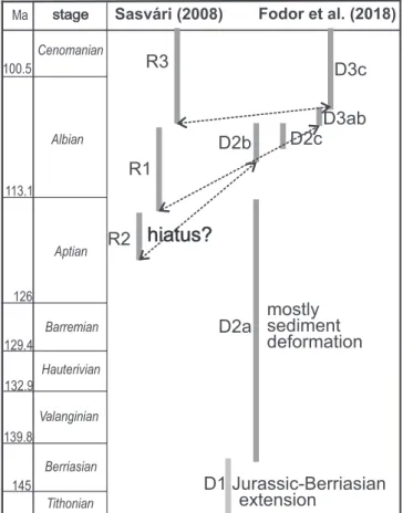
the presence of several structural phases. Following early structural works byBada et al. (1996), more recently,Sasvari (2008, 2009)and Fodor (2010)suggested that there were three contractional defor- mation phases to have occurred during the Aptian to Albian, during and after clastic foreland sedimentation (Fig. 2).Fodor et al. (2018) subdivided the evolution into three tectonic phases with six sub- phases, which can be compared to that outlined in earlier works, but they refined the subdivision of tectonic evolution will be shown later onFig. 12.
Although there are slight deviations in shortening directions (compression), the main difference is in timing with respect to the termination of clastic sedimentation. Sasvari (2008, 2009) sug- gested that part of the deformation, namely his first phase, occurred during the early(?) AptianFig. 2.
He postulated a hiatus or a very low deposition rate within the Lt-36 borehole, prior to deposition of the KbC. He attributed an Aptian date to the missing interval that might correspond to a structural deformation phase. In contrast,Fodor et al. (2018)sug- gested continuous sedimentation up to the KbC. The onset of the oldest Cretaceous deformation (D2b and D2c subphases) took place after clastic deposition ended in the Gerecse clastic basin. Following stratigraphic concepts, he attributed an earliest Albian date to the D2b-c subphases. In both concepts, this early deformation was connected to foreland basin evolution and also to formation of the forebulge and southwestern maiolica basin (Fig. 1) (Tari, 1994;
Sasvari, 2009). The direction of compression could have been be- tween the NeS to the ENEeWSW.
The second deformation phase (R1 ofSasvari, 2008; D3a-b of and Fodor et al., 2018), shown inFig. 12, was a shortening with folding, the compressional axes of which ranged from EeW to NWeSE and geodynamic connections strongly varying according to authors. The middle or late Albian to Cenomanian third phase with a NWeSE to NNWeSSE shortening (R3 ofSasvari, 2008; D3c of Fodor et al., 2018) undoubtedly marks the Late Cretaceous Eo- Alpine orogeny (Tari, 1994; Sasvari, 2008). According to several authors (e.g.,Haas and Csaszar, 1987; Tari, 1994; Sasvari, 2008) the typical folded character of the central and southern TR is only due to the third phase (Fig. 12; marked R3, D3c). On the other hand, Fodor (2010) considered the second phase to mark the onset of regional folding in the TR (D3ab), while the third phase indicated additional shortening only. Thus, knowledge of the age of thefirst and second phase constrains the age of the foreland-related and subsequent Eoalpine deformations and also the change between the two major geodynamic events.
4. Localities and general remarks
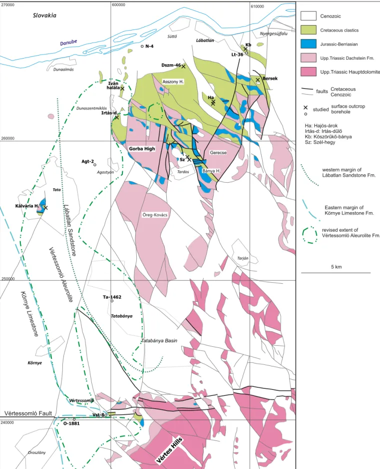
Irtasd}ul}oeThis outcrop lies in the western Gerecse (co-ordi- nates: 1823001.94" E, 4741046.59.6200N). Thefine-grained marly sequence lies above the bulk of a sandstone unit, although a few metres of sandstone cover the marlstone. The site was earlier interpreted to represent the Vertessomlo Aleurolite Formation.
Ivan halalaeThis outcrop (co-ordinates: 1823033.1900E, 47420 53.7000N) exposes sandstone, but geophysical data seem to indicate intercalation withfine-grained strata (Zalai et al., 2015).
DSZM-046 outcrop(co-ordinates: 1825058.1400E, 4743051.3900 N)esamples (numbered DSZM-046/1e2) were taken from a small valley in the northern Gerecse from a grey, silty claymarl which was expected to represent the Vertessomlo Aleurolite Formation on the basis of dip data and geophysical measurements (Zalai et al., 2015), but present nannofossil investigations refute this option and date these rocks as Aptian.
Szel-hegyethese outcrops expose afine-grained siltstone just above some sandstone layers of the Labatlan Formation (numbered as 2014-02-18 and 2014-03-04; co-ordinates: 1827030.1700E 47
Fig. 1. A.Tectonic sketch of the Transdanubian Range (TR) and its surroundings (afterSchmid et al., 2008; modified byFodor et al., 2017). Locations of Early Cretaceous clastics after Faupl and Wagreich (1992), Gorican et al. (2012)andLuzar-Oberiter et al. (2012); the AlbianeCenomanian Tannheim-Losenstein Basin afterWagreich (2001, 2003). Note that the
40015.7200 N and 1827033.5200E, 4740019.1100 N). These rocks were literally attributed to the early Albian Vertessomlo Aleurolite Formation (Sztano et al., 2018) on the basis of lithological aspects, but without any palaeontological evidence.
Hajos-arokethis outcrop (co-ordinates: 1828037.8700E, 47420 24.8200N) exposes sandstones with calcareous intercalations; these were assigned to the Labatlan Sandstone Formation by Fül€op (1958). Sedimentological characters have recently been revised by Sztano et al. (2018). In the uppermost part of the outcrop, conglomerate intercalations can be observed; these may appear similar to the K€osz€or}uk}obanya Conglomerate Member of the Labatlan Sandstone Formation.
Kalvaria-domborTata(co-ordinates: 18190 03.5600E, 47380 21.7400 N) is a classic locality of Hungarian geology (Fül€op, 1976;
Haas and Hamor, 2001), at which the crinoidal Tata Limestone Formation overlies the JurassiceLower Cretaceous maiolica lime- stone. In between these units submarine hardground-related pockets were found, infilled with a huge amount of glauconitised or phosphatised macrofossil internal moulds. Ammonites from the Epicheloniceras martinitoHypacanthoplites jacobi standard Medi- terranean Ammonite Zones (SMAZ), of early late Aptian to earliest Albian age (sensu Kennedy et al., 2000) have been described (Szives, 2002; Szives et al., 2007).
K€osz€or}uk}obanyaeat this outcrop (co-ordinates: 1830019.3800E, 47 440 40.6700 N), rocks represent the top part of the Labatlan Sandstone Formation; in other words, the youngest exposed part of the Lower Cretaceous clastic sequence in the Gerecse Mountains (Figs. 3, 10, 11). The K€osz€or}uk}obanya Conglomerate (KbC) Member is part of a coarsening-upward clastic sequence of the Labatlan Sand- stone Formation and is underlain by sandstones and siltstones, which has been determined in the Labatlan Lt-36 well which was drilled here. The KbC conglomerate was interpreted as a submarine channel of a deep-sea fan and, on the basis of nannofossils, it was assigned an early Albian (NC8 zone) date (Sztano and Baldi-Beke, 1992).Fogarasi (2001)had no smear slides from this outcrop available; he used data supplied by Baldi-Beke (Sztano and Baldi-Beke, 1992).
Labatlan Lt-36 borehole(co-ordinates: 1830024.8700E, 47440 36.5700N)ethis was sunk at the locality of K€osz€or}uk}obanya. In its uppermost part, a c. 30-m-thick, fine-grained deposit of silty sandstone and siltstone of the Labatlan Sandstone Formation was penetrated.
Neszmely N-4 borehole(co-ordinates: 1823054.1500 E, 47440 19.8200 N) e this penetrated the Labatlan Sandstone Formation down to a depth of 421 metres. Between 156.0 and 351.0 metres, a rich ammonite assemblage was found (Horvath, 1978a, b).
Tatabanya Ta-1462 borehole(co-ordinates: 1838045.2400E, 47 5709.2300N)ethis borehole was drilled in 1962 and penetrated the Vertessomlo Aleurolite Formation to a depth of 382.2 metres in the town of Tatabanya.
Vertessomlo Vst-8 borehole(co-ordinates: 1822046.1900E, 47 30027.4300N)ethis was sunk in the northern part of the Vertes Mountains (Csaszar, 1995, 2002). The sequence starts with the crinoidal Tata Limestone Formation, then grading upwards into a fine-grained sequence classically attributed to the early Albian Vertessomlo Aleurolite Formation (Csaszar, 1996) with intercala- tion of the pachyodont-bearing K€ornye Limestone Formation.
Albian rocks were overthrust by the Tata Limestone Formation.
Agostyan Agt-2 borehole(co-ordinates: 1821044.0100E, 47390 59.9300N)ethis penetrated a massive thickness of 400 metres of Vertessomlo Formation (Csaszar, 1985). Its importance is the huge thickness of the same sedimentary formation, representing a relatively short time period.
Oroszlany O-1881 borehole(co-ordinates: 1820055.2300E, 47 3009.4400N)ethis also penetrated the Vertessomlo Formation and contains a fragment of the ammonite zonal index, Douvilleiceras mammillatum, at a depth of 338.4 metres, as published bySzives et al. (2007, p. 78, pl. 25,fig. 3). Thus, this unit can be placed in theDouvilleiceras mammillatumSMAZ. Preparation of smear slides was not deemed necessary, because on the basis of this ammonite its age could be determined precisely.
The Bersek Hill sections (F}ozy, 1995; Bajnai et al., 2017) are beyond the scope of the present study for two reasons: they are older, i.e., up to theToxancyloceras vandenheckiiSMAZ, in contrast to younger sections investigated for the present study the age of which correspond to theMartellites sarasiniSMAZ. Besides, detailed integrated ammonite, nannofossil and belemnite data of Bersek Hill were previously published byF}ozy and Fogarasi (2002)andF}ozy and Janssen (2009).
5. Material and methods
We sampled outcrops and borehole intervals where the presence of the upper part of the clastic Lower Cretaceous sequence, the upper
original Cretaceous position of Fatra-Klappe units was more to the south (Plasienka, 2003). BeC. Palaeogeographical sketches of the Alpine-Carpathian-Dinaridic area in two time slices (Handy et al., 2010), which may correspond to the D2a and D2b-c subphases of the Gerecse Mountains. Note the position of the TR within the green ellipse. Red labels and green patches refer to Early Cretaceous clastic basin remnants and for the possible extent of the foreland basin. Medvednica (M) was located below the ophiolite sheet.
Cenomanian
Albian
Aptian
Barremian Hauterivian
Valanginian
Berriasian Tithonian 139.8
129.4 126 113.1 100.5 Ma
132.9
145
stage
Sasvári (2008) Fodor et al. (2018)
hiatus?
D3ab D3c
D2b D2c
D2a
D1 Jurassic-Berriasian extension
mostly sediment deformation R2
R1 R3
Fig. 2.Previous concept and postulated ages of Early Cretaceous deformation phases in the Gerecse Mts. Dashed lines indicate the possible correlations of the onset of the deformation phases. Note that the revised versions of the age of deformation phases are given after the biostratigraphical chapters, onFig. 12.
Környe Limestone
Vértessomló Aleurolite Lábatlan Sandstone
Öreg-Kovács Asszony H.
Gerecse
Bánya H.
Kálvária H.
Sz
Ha Dszm-46
Irtás-d.
Iván halála
Bersek Kb
Lt-36
Agt-2
N-4
Vst-8 Ta-1462
O-1881
Cenozoic Cretaceous clastics
Jurassic-Berriasian
Upp.Triassic Dachstein Fm.
Upp.Triassic Hauptdolomite
surface outcrop borehole studied
Ha: Hajós-árok Irtás-d: Irtás-dűlő Kb: Köszörűkő-bánya Sz: Szél-hegy
Cretaceous Cenozoic faults
revised extent of Vértessomló Aleurolite Fm.
western margin of Lábatlan Sandstone Fm.
Eastern margin of Környe Limestone Fm.
5 km Lábatlan
Nyergesújfalu Danube
Slovakia
Dunaszentmiklós
Agostyán
Süő
Dunaalmás
Tardos
Tarján
Oroszlány Környe
Tatabánya
Vértessomló Tata
Tatabánya Basin Gorba High
Vértes Hills Vértessomló Fault
270000
260000
250000
240000
600000 610000
Fig. 3.Geological map of the Gerecse and northern Vertes Mountains (Fodor and F}ozy, 2013), showing the localities and boreholes mentioned in the text.
part of the Labatlan Sandstone Formation, could be postulated (i.e., N- 4 borehole, Ivan halala, Hajos-arok and K€osz€or}uk}obanya outcrops). In addition, the previously assumed occurrences of the early Albian Vertessomlo Aleurolite Formation (Irtasd}ul}o, DSZM-46, Szel-hegy) are also investigated here for thefirst time in order to determine their exact age. The boreholes Vst-8, Ta-1462 and O-1881 were re-sampled (Fig. 3) and available ammonite data are combined with nannofossils.
Analyses of ammonite faunas were carried out previously for bore- holes that penetrated the deeply buried Vertessomlo Aleurolite For- mation (Szives et al., 2007, pp. 34e42) and the underlying crinoidal limestone unit (Tata Limestone Formation) at various localities in the northwestern Vertes foreland (Szives et al., 2007, p. 78).
New smear slides were prepared for Irtasd}ul}o (1), Ivan halala (1), the outcrop DSZM-46 (5), Szel-hegy (4), core material of boreholes Lt-36 (1), N-4 (9), Vst-8 (10) and Agt-2 (1), following the
smear slide technique described byBown and Young (1998). The original smear slides of Baldi-Beke (Sztano and Baldi-Beke, 1992) from KbC (6) and of Fogarasi (Fogarasi, 2001; F}ozy et al., 2002) from borehole Lt-36 (12) were also re-examined. Smear slides (34) of the Vst-8 borehole and the Hajos-arok (8) and Tata Kalvaria-domb (5) localities investigated byFogarasi (2001)must be considered lost.
A quantitative nannofossil analysis is beyond the scope of the present paper, although, based on work byHerrle and Mutterlose (2003), three basic quantitative classes were used to measure nan- nofossil abundances, as follows:common: more than 1 specimen per field of view (FOV), frequent: 1 specimen per 2e10 FOV,rare: 1 specimen per 11 FOV. Data sheet of nannofossil abundances including all localities is attached as aSupplementary Appendix 1.
Ammonite and nannofossil taxa cited in the text are listed in the Supplementary Appendix 2 in order of classification (Bown and Fig. 4.Calcareous nannofossils from the Neszmely N-4 borehole, northwest Hungary. Pictures are from younger (top) to older rocks (bottom) in this borehole. All images were taken at a magnification of 1250; scale bar equals 1mm 1.Retecapsa angustiforata, 158.0 m; 2.Helenea chiastia, 158.0 m; 3.Watznaueria barnesiae, 158.0 m; 4e5.Diazomatolithus leh- mannii, 158.0 m; 6.Braarudosphaerasp., 158.0 m; 7.Micrantholithus stellatus, 158.0 m; 8.Nannoconussp., 158.0 m; 9.Assipetra terebrodentarius, 158.0 m; 10.Watznaueria bayackii, 169.0 m; 11.Percivalia fenestrata, 169.0 m; 12.Micratholithus obtusus, 169.0 m; 13.Percivalia fenestrata, 198.0 m; 14.Retecapsa surirella, 198.0 m; 15.Helenea chiastia, 198.0 m; 16.
Repagulum parvidentatum, 198.0 m; 17.Nannoconussp., 198.0 m; 18. nannofossil fragment of uncertain identity, 198.0 m; 19.Hayesites irregularis, 198.0 m; 20.Percivalia fenestrata, 219.0 m; 21.Diazomatolithus lehmannii, 219.0 m; 22.Braarudosphaera pseudobatilliformis, 219.0 m; 23.Braarudosphaera regularis, 219.0 m; 24.Assipetra terebrodentarius, 219.0 m; 25.
Nannoconus steinmannii, 351.0 m; 26.Nannoconus inornatus, 351.0 m; 27.Micrantholithus obtusus, 351.0 m; 28.Micrantholithussp., 351.0 m; 29. ?Braarudosphaerasp., 351.0 m; 30.
Assipetra terebrodentarius, 351.0 m.
Young 1997); ammonite nomenclature followsWright et al. (1996), while the taxonomy of nannofossil taxa is adopted from the Nan- notax3 website (Young et al., 2014).
Calcareous nannofossils are rare to common and moderately to well preserved in the smear slides studied. Photographs were taken with a Nikon Eclipse 50iPol microscope at a magnification of1250
and a MediaCybernetics Evolution MP Colour digital microscope camera.
The smear slide collections of both Baldi-Beke and Fogarasi are housed in the Micropalaeontological Collections of the Hungarian Natural History Museum (HNHM, Budapest). Here, the newly pre- pared ones are also deposited.
Fig. 5.Calcareous nannofossils from Szelhegy, northwest Hungary. All images were taken at a magnification of 1250; scale bar equals 1mm. From sample Szelhegy 02-18: 1.
Staurolithites crux; 2.Zeugrhabdotus diplogrammus; 3.Zeugrhabdotus embergeri; 4.Zeugrhabdotus noeliae; 5.Zeugrhabdotus?bicrescenticus; 6.Rhagodiscus asper; 7.Retecapsa sur- irella; 8.Diazomatolithus lehmannii; 9.Watznaueria barnesiae; 10.Watznaueriasp.; 11.Watznaueria bayackii; 12.Micrantholithus obtusus; 13.Micrantholithus hoschulzii; 14.
Micrantholithus?obtusus; 15.Nannoconussp.; 16.Nannoconussp.; 17.Nannoconus kamptneri; 18.Nannoconus kamptneri; 19.Nannoconus steinmannii; 20.Eprolithusfloralis; 21.
Assipetra terebrodentarius; 22.Hayesites irregularis.From sample Szelhegy 03-04: 23.Tegumentum stradneri; 24.Zeugrhabdotus diplogrammus; 25.Zeugrhabdotus embergeri; 26.
Retecapsa surirella; 27.Flabellites oblongus; 28.Helenea chiastia; 29.Rhagodiscus infinitus; 30.Nannoconus?inornatus; 31.Nannoconus?inornatus; 32.Micrantholithus obtusus; 33.
Micrantholithus obtusus; 34.Micrantholithus obtusus; 35.Micrantholithus hoschulzii; 36.Assipetra terebrodentarius.
5.1. Comments on nannofossil and ammonite biostratigraphy 5.1.1. Nannofossil zonation
Due to the former low-latitude geographical position of the sedi- mentary sequences of the TR examined (Csontos and V€or€os, 2004), we here use Tethyan zonations which followBown et al. (1998)and the Geological Time Scale (GTS;Ogg et al., 2016). The latter is a compila- tion of several sources, includingRoth (1978), Bralower et al. (1995) and BowninKennedy et al. (2000, 2017). The GTS also provides an integrated chart of biozonations, together with magnetostratigraphy.
In addition,Mahanipour et al. (2011,fig. 7)summarised Barremiane Aptian nannofossil zonations currently in use.
5.1.2. Ammonite zonation
Standard Mediterranean Ammonite Zones (SMAZ) are used here (compareReboulet et al., 2014, 2018), with the exception of the
upper Aptian Hypacanthoplites jacobiZone (sensu lato), which is based on KennedyinKennedy et al. (2000, p. 601)and has been adopted by the latest version of the GTS. The Barremian/Aptian boundary still is problematic on the basis of ammonites due to taxonomic debates (Frau et al., 2017; Reboulet et al., 2018).
5.1.3. The Aptian/Albian boundary (AAB) problem
During the past two decades intensive integrated research on the Aptian/Albian boundary (AAB) has been carried out (Hart et al., 1996; Kennedy et al., 2000, 2014; Hancock, 2001; Owen, 2002;
Petrizzo et al., 2012). Recently, Kennedy et al. (2014)have sum- marised the results and remaining problems. In 2016, the GSSP of the AAB was ratified (Kennedy et al., 2017).
According toKennedy et al. (2000), the upper AptianH. jacobi SMAZ extends to above the AAB, which means that the top of the H. jacobiSMAZ does not correspond either to the base of the Albian, Fig. 6.Calcareous nannofossils from the DSZM-046 locality, northwest Hungary. All images were taken at a magnification of 1250; scale bar equals 1mm. From sample DSZM-046/
1: 1.Staurolithitessp.; 2.Zeugrhabdotus embergeri; 3.Zeugrhabdotus noeliae; 4.Rhagodiscus angustus; 5.Rhagodiscus asper; 6.Rhagodiscus asper; 7.Nannoconus inornatus; 8.
Nannoconus inornatus; 9.Nannoconussp.; 10.Nannoconus circularis; 11.Nannoconussp.; 12.Micrantholithussp.; 13.Braarudosphaera pseudobatilliformis; 14.Braarudosphaera reg- ularis; 15.Braarudosphaera regularis; 16.Assipetra terebrodentarius; 17.Hayesites irregularis.From sample DSZM-046/2: 18. ?Staurolithitessp.; 19.Zeugrhabdotus bicrescenticus; 20.
Watznaueria bayackii; 21.Watznaueria okadai; 22.Retecapsa angustiforata; 23.Eiffelithus striatus; 24.Nannoconus minutus; 25.Nannoconus kamptneri; 26.Nannoconus truittii; 27.
Micrantholithus obtusus; 28.Micrantholithus hoschulzii; 29.Micrantholithus hoschulzii; 30.Micrantholithus hoschulzii.
nor the base of nannofossil zone NC8. An integrated zonation of relevant sections in the Vocontian Basin, as published byHerrle and Mutterlose (2003), also supports this view. According to Bown (in Kennedy et al., 2000,fig. 29), thefirst occurrence (FO) ofPredis- cosphaera columnata(circular) postdates the last occurrence (LO) of Leymeriella tardefurcata, which fact was not adopted in the GTS.
In addition, the most recent geomagnetic data (Ogg et al., 2016) define the base of M0R as the base of the Aptian at 126.3 Ma, which is 3 myr older than in the previous versions of the time scale.
On the basis of nannofossils, Bown (inKennedy et al., 2000, p.
617e621) summarised his opinion as follows,‘The FO of the genus ofPrediscosphaera(P. spinosa) lies somewhere in the upper Lower Aptian (Neohibolites ewaldibelemnite Zone) and thus cannot be used to solve the Aptian/Albian boundary problem’. Bown dis- cussed the evolutionary lineage and FO ofPrediscosphaeraspp. in detail and concluded that,‘P. columnatasensu stricto (with circular rim) can remain as a proxy as the boundary marker itself’, which idea was later retained byKennedy et al. (2014), but with lesser confidence. Besides, as Bown (in Kennedy et al. 2000, p. 619) emphasised:‘… I am confident the lowest P. columnataat Pre- Guittard is low in thejacobi ammonite Zone in the upper Upper Aptian’. For this reason, the base of nannozone NC8 does not correspond to the AAB.
The position of the boundary is of special interest in the Vst-8 and Ta-1462 boreholes, as well as at the outcrops of Tata Kalvaria-domb and K€osz€or}uk}obanya.
6. Results
Our aim was to calibrate the best possible age of the rocks sampled so as to clarify certain sedimentary units and the timing of tectonic movements and structural deformations. However, palaeobiogeographical and palaeoecological implications, as based on nannofossils, are beyond the scope of the present paper. Every
locality or borehole is described according to zone or subzone that either represents the longest, or the more likely time interval of the sequence sampled.
6.1. Biostratigraphy
Unless indicated otherwise, data fromYoung et al. (2014) are used here for thefirst (FO) and last occurrences (LO) of taxa.
6.1.1. Flabellites oblongusZone (NC5), upper Hauterivianeupper Barremian
This zone is defined as the interval between the FO of Cru- ciellipsis cuvillieriand the FO ofHayesites irregularis.
6.1.1.1. Subzone NC5E. This subzone is defined as the interval be- tween the FOs ofFlabellites oblongusandHayesites irregularis.
6.1.1.1.1. Neszmely N-4 borehole. In this borehole a siliciclastic sedimentary unit was penetrated between depths of 421 to 156 metres. In a sample from a depth of 351.0 m, Micrantholithus obtusus, Micrantholithus hoschulzii, Nannoconus steinmanni, ? Braarudosphaerasp. andAssipetra terebrodentariuswere found. The 284.0 m sample was barren, while the one from 219.0 m contained a very poor nannoflora, with some rare examples of species of Watznaueriainclusive ofWatznaueria bayackii, plusM. hoschulzii, Braarudosphaera regularis, B. pseudobatilliformis, Diazomalithus lehmanniiandRetecapsa surirella. The smear slide from 198.0 m contains a distinctly early Aptian nannoflora, with rare presence of the zonal indexHayesites irregularis,Helenea chiastia,R. surirella andW. bayackii.Only species of Watznaueriaare very abundant, other forms are rare. The sample from 189.0 m contains a poor nannoflora in a moderate state of preservation with frequent nannoconids and species of Watznaueria. A smear slide from a depth of 169.7 m yielded Retecapsa crenulata, W. bayackii and B. regularis. In the upper levels of the borehole, at a depth of Fig. 7.Calcareous nannofossils from the localities Irtasd}ul}o and Ivan halala, northwest Hungary. All images were taken at a magnification of 1250; scale bar equals 1mm. From Irtasd}ul}o: 1.Percivalia fenestrata; 2.Helenea chiastia; 3.Nannoconus steinmannii. From Ivan halala: 4.Staurolithites crux; 5.Owenia hillii; 6.Rhagodiscus angustus; 7.Rhagodiscus asper;
8.Helenea chiastia; 9.Watznaueria barnesiae; 10.Owenia dispar; 11.Owenia partitum; 12.Nannoconuscf.circularis; 13.Nannoconuscf.circularis; 14.Nannoconus bucheri; 15.
Braarudosphaerasp.; 16.Braarudosphaera batilliformis; 17.Micrantholithus obtusus; 18.Eprolithusfloralis.
158.0 m, the rock colour changes from grey to purplish grey. A smear slide prepared from this depth yielded a singleMicrantholi- thus stellatus, and rare specimens ofR. crenulata,A. terebrodentarius, Cyclogelosphaera margerellii, B. regularis, D. lehmannii and H. chiastia.
On the basis of ammonites,Horvath (1978a, b)placed the Bar- remian/Aptian boundary at 187 m. A late Barremian-early Aptian ammonite fauna, with records of Toxancyloceras vandenhecki at 351 m, Macroscaphites (Costidiscus)microcostatusand Barremites difficilisare at 187 m. The ammonite fauna is now being revised, but Fig. 8.Calcareous nannofossils from K€osz€or}uk}obanya; original samples of M. Baldi-Beke. All images were taken at a magnification of 1250; scale bar equals 1mm. From sample 5:
1.Zeugrhabdotus embergeri; 2.Rhagodiscus asper; 3.Watznaueria ovata; 4.Diazomatolithus lehmannii; 5.Assipetra terebrodentarius; 6. ?Radiolithus planus; 7. ?Lithraphiditessp. From sample 21, layered: 8.Tegumentum stradneri; 9.Staurolithites crux; 10.Staurolithitessp.; 11.Helenea chiastia; 12.Rotelapillus crenulatus; 13.Retecapsa surirella; 14.Flabellites oblongus;
15.Watznaueria britannica; 16.Laguncula dorotheae; 17.Tubodiscus burnettiae; 18.Braarudosphaera regularis; 19.Micrantholithus obtusus; 20.Micrantholithus hoschulzii; 21.
Micrantholithus hoschulzii; 22.Nannoconus circularis; 23.Eprolithusfloralis; 24. ?Hayesites irregularis; 25.Lithraphidites carniolensis.From sample 21, marly: 26.Staurolithites crux; 27.
Laguncula dorotheae; 28.Nannoconus kamptneri; 29.Micrantholithus hoschulzii; 30.Micrantholithus hoschulzii; 31.Micrantholithus hoschulzii; 32.Eprolithusfloralis; 33.Assipetra terebrodentarius.
a comprehensive age assignment is already available. At 158 m a specimen ofCheloniceraswas found, at 156 m one ofDeshayesites, both genera being exclusive to the lower Aptian. Full list of ammonite taxa identified byHorvath (1978a, b)with her original identifications (which is not have been revised yet) is listed in the Supplementary Appendix 1.
Csaszar (1995)reported that the upper 70.2 metres of the core (i.e., between 158 and 87.8 m) were of late Aptian age. Unfortu- nately, this part of the core seems to be lost and because of the lack of fossil evidence we cannot be certain of this late Aptian date for this missing core interval.
In summary, we can place the Barremian/Aptian boundary (i.e., base of NC6) at thefirst certain occurrence ofBraarudospera regu- larisandB. pseudobatilliformisat a depth of 219 m. Although these are not zonal indexes, species ofBraarudosphaerahave no certain records below the Aptian (P. Bown, pers. comm., November, 2017).
The FO ofH. irregularisis at a depth of 198 m undoubtedly docu- ments an Aptian time interval. Below 219.0 m zone NC5, above the presence of zone NC6 is assumed. In view of the absence ofEpro- lithusfloralis, which would mark the base of zone NC7, the presence of this zone cannot be verified over the entire length of the core.
This nannofossil zonation is in slight contradiction with the ammonite record, which placed the Barremian/Aptian boundary at 187 m.
6.1.1.1.2. Irtasd}ul}o outcrop. Nannofossils are very rare in this sample and poorly preserved, being mostly eroded and/or dis- solved.Watznaueriais the sole fairly common taxon. Single speci- mens of Nannoconus steinmannii, Percivalia fenestrata and H. chiastiawere noted.Nannoconus steinmanniihas its last occur- rence in the earliest Aptian (P. Bown, pers. comm., November, 2017). Watznaueria bayackii is also frequent. The presence of N. steinmanniiand the absence ofH. irregularisandBraarudosphaera lead us to conclude that the age is latest Barremian (subzone NC5E).
Nannofossils from this outcrop are illustrated inFig. 7.
6.1.1.1.3. Szel-hegy outcrops. Nannoflora of sample 2013-02-18 comprises very abundantWatznaueriaand common nannoconids, N. kamptneribeing commoner thanN. steinmannii. One specimen of H. irregulariswas also found, together with rareM. hoschulziiand M. obtusus. A form ofMicrantholithus?obtusus(Fig. 5/14) resembles the early Valanginian boreal zonal index form,Micrantholithus? speetonensis. We conclude that the age of this sample is early Aptian (subzone NC6A), on the basis of the co-occurrence of the zonal index and N. steinmannii. The nannoflora of sample 2013-03-04 comprises one specimen of F. oblongus, rare M. obtusus, rare W. bayackii,Rhagodiscus amplus,Rhagodiscus infinitusand Rhago- discus asper.Nannoconids are relatively frequent, withNannoconus
?inornatusandN. kamptneri.The absence ofH. irregularis, and the presence ofF. oblongusandN.?inornatussupports subzone NC5E
Fig. 9.Calcareous nannofossils from the Vertessomlo Vst-8 borehole. All images were taken at a magnification of 1250; scale bar equals 1mm 1, 2. ?Arkhangelskiella cymbiformis, 112.0 m; 3.Zeugrhabdotus embergeri, 112.0 m; 4. ?Clausicoccus subdistichus, 112.0 m; 5.Cretarhabdus inaequalis, 112.0 m; 6. ?Cretarhabdussp.; 7.Watznaueriacf.britannica, 112.0 m; 8.
Prediscosphaerasp., 112.0 m; 9.Prediscosphaera, spine top, 112.0 m; 10.Nannoconus truittii rectangularis, 112,0 m; 11.Nannoconus truittii rectangularis, 112.0 m; 12.Assipetra tere- brodentarius, 112.0 m; 13.Zeugrhabdotussp., 117.9 m; 14.Zeugrhabdotus diplogrammus, 117.9 m; 15.Watznaueriasp., 117.9 m; 16.Nannoconus truittii, 117.9 m; 17. inorganic crystal; 18.
Zeugrhabdotus diplogrammus, 122.9 m; 19.Nannoconus truittii, 122.9 m; 20.Nannoconussp., 122.9; 21.Assipetra terebrodentarius, 122.9 m; 22.Nannoconussp., 169.0 m; 23.Nan- noconussp., 169.0 m; 24.Hayesites irregularis, 169.0 m.
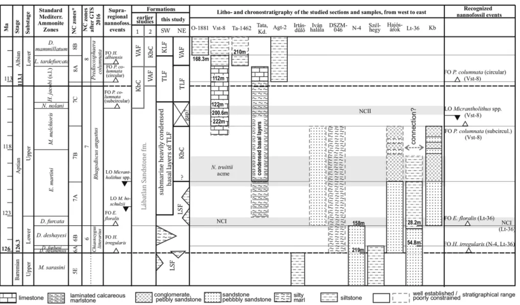
Fig. 10.Biostratigraphical results of the sites studied and revised age of clastic sequences of the northeastern Transdanubian Range. Note that investigated zones are scaled. From left to right: age and timing followsOgg et al. (2016), SMAZ are afterReboulet et al. (2014), with the exception of the upper AptianjacobiZone sensu lato, which is after KennedyinKennedy et al. (2000, 2016). Nannofossil zonation with asterisk is afterBown et al. (1998); the uppermost Aptian to lowermost Albian follows BowninKennedy et al. (2000, 2016). Nannofossil zonation and supraregional events are fromOgg et al. (2016), which is based on a "compilation of several sources", includingRoth (1978), Bralower et al. (1995)and BowninKennedy et al. (2000, 2016). Formations after (1):Csaszar (1995)and (2):Sztano et al. (2018)are compared to the present study. KLF: K€ornye Limestone Formation; TLF: Tata Limestone Formation; LSF: Labatlan Sandstone Formation; KbC: K€osz€or}uk}obanya Conglomerate Member of Labatlan Sandstone Formation; VAF: Vertessomlo Aleurolite Formation. Kb: K€osz€or}uk}obanya. Nannoconid crises I (NCI) and II (NCII) are indicated as light grey shaded areas, also as theNannoconus truittiiacme, on the basis ofErba (1994)andHerrle and Mutterlose (2003).
Szivesetal./CretaceousResearch91(2018)229e250241
for this sample, which presumably makes it older than the previous sample from Szel-hegy. In summary, we can point out that samples from Szel-hegy are not of an Albian date, contrary to previous as- sumptions. (SeeFig. 5).
6.1.2. Chiastozygus litterariusZone (NC6), lower Aptian
This is an interval zone between the FOs ofHayesites irregularis andEprolithusfloralis.
It has been determined at Hajos-arok, which is discussed below under subzone NC7B.
6.1.2.1. Subzone NC6A. This subzone is defined as the interval be- tween the FO ofHayesites irregularisand the LO of Conusphaera rothii. The presence of this subzone has been noted in the upper
part of the core of the Neszmely N-4 borehole, Szel-hegy (both discussed above, under subzone NC5E), also at Hajos-arok and in the Labatlan Lt-36 borehole (both discussed below under subzone NC7A).
6.1.2.2. Subzone NC6B. This interval is defined as the interval be- tween the LO ofConusphaera rothiiand the FO ofEprolithusfloralis.
This subzone could be proved in the Labatlan Lt-36 borehole below 54.8 m, on the basis of the FO ofH. irregularis. Nannofossil taxa from this borehole are discussed below, under subzone NC7A.
6.1.3. Rhagodiscus angustusZone (NC7), upper Aptian
This zone is defined as the interval between the FOs ofEprolithus floralisand circularPrediscosphaera columnata.
Fig. 11.New lithostratigraphical chart of Lower Cretaceous clastic formations of the northeastern Transdanubian Range, showing the positions of sites sampled [modified after Csaszar (1995, 1996)andSztano et al. (2018)]. Note that the zones studied are scaled. Abbreviation: Mb: member. Columns on the left are the same as inFig. 10. The Aptian/Albian boundary is marked with a dashed line on the right. Two ammonite zones, ofDeshayesites oglanensis(1) andDeshayesites forbesi(2), are both below theD. deshayesiZone.
6.1.3.1. DSZM-046 outcrop. Sample DSZM-046/1 contains a diverse nannoflora, with rare occurrences of M. hoschulzii, R. asper, R.
angustus,Staurolithitessp.,Zeugrhabdotus embergeri,Zeugrhabdo- tus noeliae and W. bayackii, co-occurring with frequent W. barnesiaeandB. regularis. A singleH. irregularishas also been documented, together with nannoconids: N. inornatus, N. circularisandNannoconussp. On the basis of the zonal index and frequent species ofBraarudosphaera, as well as the decrease in numbers ofMicrantholithus, we date this sample as zone NC6 or zone NC7.
Sample DSZM-046/2 has a diverse nannoflora consisting of frequent W. bayackii and M. hoschulzii, and rare occurrences of Eiffelithus striatus, Staurolithites sp., N. kamptneri, Nannoconus minutusandNannoconus truittii. A single specimen ofZeugrhab- dotus?bicrescenticushas also been noted. Age-diagnostic forms are absent from this sample, but on the basis of the co-occurrence of M. hoschulziiandN. truittii, its age can be can be estimated as zone NC7. More precise subzonal identification was not possible due to a lack of subzonal indexes for both samples. In summary, we can remark that samples from outcrop DSZM-046 obviously are not Albian in age. (SeeFig. 6)
6.1.3.2. Ivan halala outcrop. The nannoflora from this locality con- tains a few specimens of Staurolithites crux, Owenia partitum, Owenia dispar, R. angustus, R. asper, H. chiastia, N. circularis, B. batilliformis, M. obtusus and E. floralis. A single specimen of Nannoconus bucherihas also been found, as well as a surprisingly young ?Owenia hillii. The FO ofE.floralismarks the base of zone NC7. On the basis of the co-occurrence ofM. obtusus,N. bucheriand N. circularis we place this sample in subzone NC7A. Species of Oweniaindicate a slightly younger (subzone NC7B) age, which is why we cannot rule out this option either. In summary, we conclude that this sample is not of Albian age, but most likely can be placed in zones NC7A/B.
6.1.3.3. Subzone NC7A. This subzone is defined as the interval be- tween the FO ofEprolithusfloralisand the LO ofMicrantholithusspp.
6.1.3.3.1. Labatlan Lt-36 borehole. For a detailed nannofossil biostratigraphy of this core reference is made toFogarasi (2001) and, in the framework of an integrated ammonite-nannofossil study, toF}ozy et al. (2002).
Fogarasi examined 12 samples from between depths of 3.3 and 98 metres, and presented a range chart of the nannoflora Fig. 12.Comparison of age, duration and shortening (stress) axes of Cretaceous deformation phases in the Gerecse and surroundings. Note that the timing of the phases in earlier works is approximate. Columns show concepts byTari (1994)andTari and Horvath (2010), Sasvari (2008, 2009), Fodor (2010), Fodor et al. (2018)and the present study. Columns on the left are the same as inFig. 10 and 11.
recognised, summarising his opinion (in F}ozy et al., 2002, Ta- ble 1,Fig. 1.) as follows,‘…. the age of the whole core can be placed between late Barremian to Aptian.’. In more detail, ’On the basis of our nannoplankton studies, we can identify forms of the NC6-NC7 zones. At 28.2 m the co-occurrence ofE.floralis and R. angustus can be recognized, which marks the base of NC7A zone. … Samples above this have not yielded bio- stratigraphically significant nannoflora, but more likely are younger in age.’
Nannoconids are missing totally between 54.8 and 28.2 m, which can be interpreted as a nannoconid crisis more likely to be NCI, considering the ammonite macrofauna that clearly represents a maximum earliest Aptian date (F}ozy et al., 2002). In smear slides prepared from samples above 33.3 m, the return of nannoconids and the presence ofMicrantholithusis remarkable, which does not really support subzone NC7B or 7C ages, as previously suggested by Fogarasi. The negative correlation between nannoconids and A. infracretacea andA. terebrodentariusas documented byHerrle and Mutterlose (2003) could be observed in these samples. In addition to the nannoconid crisis (NCI) around the boundary of subzones NC6B/7A, first pointed out byErba (1994), Herrle and Mutterlose (2003) detected a younger nannoconid crisis around the boundary between subzones NC7B/7C, which they named nannoconid crisis II (NCII). They also correlated these crises with major carbonate platform-drowning events.
In the Lt-36 borehole, species of Micrantholithus occur also above the crisis.Young et al. (2014)placed the LO ofM. hoschulziiin the late Aptian substage, as Erba (1996)had done at the top of subzone NC7C.Bralower et al. (1995)positioned the top of subzone NC7A on the basis of the LO ofM. hoschulzii; the 2016 version of the GTS also shows the last Micrantholithusspp. to mark the top of subzone NC7A.
In summary, below 54.8 m, the presence of subzone NC6A is documented on the basis of the FO ofH. irregularis, in accordance with ammonite data (F}ozy et al., 2002). Between 54.8 and 28.2 m, subzone NC6B has been determined. The zonal indexR. angustus, together withE.floralis, appears at 28.2 m, which may mark the base of subzone NC7A. In contrast to the original concept by Fogarasi, we have found no evidence for a younger (subzones NC7B or NC7C) age of the upper part of the Lt-36 core, not among nan- nofossil taxa, nor among ammonites.
6.1.3.3.2. Hajos-arok. Nannofossils of this locality were exam- ined byFogarasi (2001), but his original eight smear slides are lost.
He described 42 species and assigned the nannoflora to subzones NC6A to NC7B, on the basis of the presence of H. irregularis, E.
floralis and Braarudosphaera hockwoldensis. The NCI was also documented within this section on the basis of an acme of A. infracretacea and A. terebrodentarius, as well as an acme of N. truittii(Erba, 1994), (Herrle and Mutterlose, 2003) in the highest samples.Bodrogi (1999)also concluded that the age of the upper beds was late Aptian. The upper part of the section at Hajos-arok has several distinctive conglomerate levels which possibly could be coeval with the conglomerates at K€osz€or}uk}obanya, but needs further micropaleontologic investigations.
6.1.3.4. Subzone NC7B. This subzone is defined as the interval be- tween the LO of Micrantholithus hoschulziiand the FO ofRhago- discus achlyostaurion.
6.1.3.4.1. K€osz€or}uk}obanya. This locality exposes the youngest sedimentary unit of the entire Cretaceous clastic succession for which the most widely divergent age assignments have been sug- gested, varying between Aptian/Albian (Sztano and Baldi-Beke, 1992) and Cenomanian (Felegyhazy and Nagymarosi, 1991, 1992).
None of these authors provided clear, identifiable images of age- indicative forms.
We re-examined the original smear slides of Baldi-Beke (see Sztano and Baldi-Beke, 1992). Of the six smear slides, three were empty, but others contain an abundant nannoflora of moderate to good preservation. The nannoflora from this locality is described in more detail in view of the conflicting age interpretations of previ- ous authors.
In sample‘5’the following forms were found:Z. embergeri,Rh.
asper,W. ovata,D. lehmannii,A. terebrodentarius, ?Radiolithus planus and ?Lithraphidites sp. Sample ‘21. layered’ yielded Tegumentum stradneri,Staurolithites crux,Staurolithites sp., H. chiastia,Rotela- pillus crenulatus, R. surirella, F. oblongus, Watznaueria britannica, Laguncula dorotheae,Tubodiscus burnettiae,B. regularis,M. obtusus, M. hoschulzii,N. circularis,E.floralis,H. irregularisandLithraphidites carniolensis.From sample ‘21. marly’, we documented S. crux, L.
dorotheae, N. kamptneri, M. hoschulzii, E. floralis and A. terebrodentarius., while Baldi-Beke mentioned but did not photograph (Sztano and Baldi-Beke, 1992) from the same sample, Prediscosphaerasp. indet. Despite detailed search, we did notfind any specimen that could be assigned to that genus.
Micrantholithus declined and disappeared across the late Barremian-early Aptian interval andBraarudosphaeraappeared in the early Aptian according to P. Bown (pers. comm., 11.2017), which implies that these samples certainly cannot be of Albian age. The LO ofM. hoschulziimarks the lower boundary of subzone NC7B (Bown et al., 1998). In contrast,Young et al. (2014)extended the range of this species to the top of the Aptian subzone NC7C, asErba (1996) had done earlier.Herrle and Mutterlose (2003, fig. 5) reported the FO ofPrediscosphaerasp. from the basal part of subzone NC7B, while, according toBralower et al. (1994, 1995)and Bown et al.
(1998), the FO of subcircular columnatais around the middle of subzone NC7C and close to the base of theNolaniceras nolaniSMAZ.
Browning and Watkins (2008)published a biostratigraphical chart on some age-diagnostic taxa from the ODP Site 1049C and came to the same conclusion as far asPrediscosphaerais concerned as Bown (inKennedy et al., 2000). According toErba (1996),M. hoschulzii, M.floralisand thefirst species ofBraarudosphaera(B. africana) can appear together without species ofPrediscosphaeraover the entire NC7 zone (ofRhagodiscus angustus) in the Tethyan realm.
Based on the above considerations, we here conclude that the age of the KbC samples falls with zone NC7 on the basis of the co- occurrence ofM. hoschulzii,E.floralisandB. regularis. Most likely are subzone NC7A or, maximum, subzone 7B on account of the relative abundance of the genusMicrantholithus. We must strongly discard its possible extension into zone NC8 or higher on account of the complete lack of any zonal or subzonal index taxa, including sub- circular or circularP. columnata. We cannot discard the option of resedimentation on the basis of the preservation. Based on geological mapping, and noted already byFül€op (1958), similar conglomeratic layers are intercalated in the upper part of the Hajos-
arok sequence. This NC7A/B zonal age is in concordance with the one suggested by redeposited orbitolinids and other large forami- nifera, which indicated a late Aptian (Schlagintweit, 1990) or
‘younger than mid-Aptian age’(G€or€og, 1995) or‘clearly mid-Aptian age’(G€or€og, 1996). This time interval equates with the top of the Epicheloniceras martinito lowerParahoplites melchiorisSMAZs.
6.1.3.5. Subzone NC7C. This subzone is defined as the interval be- tween the FOs ofRhagodiscus achlyostaurion andPrediscosphaera columnata.This subzone cannot be determined on the basis of the material examined herein.
6.1.4. Zone NC8, uppermost Aptian-lowermost Albian
This zone represents the interval between the FOs of Predis- cosphaera columnataandAxopodorhabdus albianus.