Table of Contents
... 1
1. 1. The objectivesand tasks of landscapeand environmentalplanning ... 2
1.1. 1.1. The interpretation of the concepts oflandscape andenvironment ... 3
1.2. 1.2. The tasks of landscape and environmental planning ... 3
1.3. 1.3. Practical applications of landscape studies ... 5
1.4. 1.4. Theapplication oflandscape studies in landscape planning ... 7
2. 2. Thetheoretical basis oflandscape planning ... 12
2.1. 2.1. Theinterpretation of thelandscapefrom theaspect of planning ... 12
2.1.1. 2.1.1. The unity anddynamism ofthe landscape ... 12
2.1.2. 2.1.2. Landscape perception as the basis of planning ... 15
2.2. 2.2. The concept of landscape planning ... 16
2.3. 2.3. Landscape planningandlandscape maintenance ... 21
2.4. 2.4. The framework system of landscape planning in Hungary ... 26
2.4.1. 2. 4. 1. About landscape classification in general ... 26
2.5. 2.5. The Historyof Hungarianlandscape classification ... 27
3. 3. Thelegal basis oflandscape andenvironmental planning ... 38
3.1. 3.1. Legislation in environmental protection ... 38
3.2. 3.2. Master plans ... 44
3.3. 3.3. Legislation in landscape preservation ... 46
4. 4. Landscape planningandland use planning ... 49
4.1. 4.1. Therelationship between land use planningand regional development ... 50
4.2. 4.2. TheEuropeanguidelines forland use planning ... 51
4.2.1. 4.2.1. The SevesoII Directive ... 52
4.2.2. 4.2.2. TheEU'sland use directive ... 52
4.3. 4.3. Land use from the point of view of agriculture andruraldevelopment ... 53
4.4. 4.4. Land useplanningfor obtaining subsidies ... 60
5. 5. Landscapeandnature conservation in landscape planning ... 61
5.1. 5.1. Landscape protection ornature conservation? ... 62
5.2. 5.2. The aspects of landscapeprotectioninlandscape planning ... 63
5.3. 5.3. Fitting into thelandscape ... 66
5.3.1. 5.3.1. Instructions for landscape compatibility ... 67
5.3.2. 5.3.2 Highlightedvaluesand areasto be treated with special attention ... 68
5.4. 5.4. Theaspects ofnature and landscape protectionin Hungary ... 69
5.5. 5.5. Case studies ... 70
5.5.1. 5.5.1. The protection of species and biotopes ... 70
5.5.2. 5.5.2. Land reclamation planning ... 71
6. 6. Landscape andenvironmental planningin the worldand in Hungary ... 74
6.1. 6.1. The history oflandscape andenvironmental planningthe world ... 74
6.2. 6.2. Landscape planningin Europe ... 77
6.3. 6.3. Landscape planningandlandscape change ... 86
6.4. 6.4. Landscape planning in Hungary ... 92
6.5. 6.4.1. Landscape planning in the recent past ... 95
7. 7.Sustainablelandscape planning ... 96
7.1. 7.1.Sustainable development andlandscape planning ... 96
7.2. 7.2. The respect of the traditions and the values of the past and sustainability ... 99
7.3. 7.3.The protection ofvalues ... 102
7.4. 7.4.Sustainable development andecosystemservices ... 104
8. 8Ecological networks, corridors andlandscape planning ... 107
8.1. 8.1.Aboutnetworks in general ... 107
8.2. 8.2.The EuropeanEcological Network ... 107
8.3. 8.3. The National Ecological Network ... 109
8.4. 8.4.EcologicalCorridors ... 110
8.5. 8.5.The role ofecological networksin planning ... 111
9. 9. The National Settlement Development Perspective and Settlement Planning ... 115
9.1. 9.1 The National Settlement Development Perspective ... 115
9.1.1. 9.1.1. Introduction ... 115
9.1.2. 9.1.2. Future prospects ... 116
9.1.3. 9.1.3. Medium-term goals until 2013 ... 116
9.1.4. 9.1.4.Institutionsand tools ... 123
9.1.5. 9.1.5. Regions for planning and statistics ... 123
9.2. 9.2. Settlement planning as part of landscape planning ... 124
9.2.1. 9.2.1.Introduction ... 124
9.2.2. 9.2.2.OTÉKas the basis of urbanplanning ... 124
9.2.3. 9.2.3. The green-space system of settlements in the OTÉK ... 125
10. 10.Landscape values to be protected ... 126
10.1. 10.1.Nature conservation andlandscape valuesto be protected ... 134
10.2. 10.2.The cadastre of biotopes ... 134
10.3. 10.3. Protected areas, species and natural values ... 135
11. 11. The EuropeanLandscape Convention ... 136
11.1. 11.1. Introduction ... 136
11.2. 11.2. The background of the origin of Convention ... 137
11.3. 11.3 Thepurpose of the Convention ... 137
11.4. 11.4. Thetasks set in the Convention ... 138
11.5. 11.5. The roleof the Conventionin Hungary ... 138
11.5.1. 11.5.1. Institutional andorganizational background ... 139
11.5.2. 12.5.2. Theimplementationof the LandscapeConvention ... 139
11.5.3. 12.5.3. The preparation of the actionplan ... 140
11.5.4. 12.5.4. The inventory andevaluation of landscapes ... 140
11.5.5. 12.5.5. The LandscapeAward ofthe European Council ... 140
11.5.6. 11.5.6. The Hungarian nationalcompetition ... 141
12. 12. Summary- steps of landscape planning ... 142
12.1. 12.1.Introduction - theapproach ... 142
12.2. 12.2. Theplanningobjectivesandtheidentity of the designer ... 143
12.3. 12.3.The process of planning ... 143
12.4. 12.4. Summary ... 144
Landscape and environment planning Kertész, Ádám
Professor
Eszterházy Károly College, Instiutue of Geography and Environmental Studies, Department of Geography
Research professor emeritus
Hungarian Academy of sciences, Research Centre for Astronomy and Earth Sciences, Geographical Institute 2013. 05. 10
This course is realized as a part of the TÁMOP-4.1.2.A/1-11/1-2011-0038 project.
Introduction
It is not indifferent to anybody whether the landscape where we spend our lifetime isbeautiful, aesthetic, that is to say goodto live in and nice to look at,or it is run-down, neglected anduntidy.Before the appearanceof man, or perhaps evenbefore the explosionof populationand theIndustrial Revolution,the landscapes of our Earth were quasi-natural landscapes, where the view was developed by nature, and itwas aesthetic, following from the nature ofthings. Sometimesexceptions may have occurred: destructions caused by landslides, volcaniceruptions, state of nature afterforest firesetc., but apart from that,thedemand for planning at landscape-levelemerged only recently.The furtherthe population increased, the more human society and theirfacilitiesexpanded, the more the question arose, that notonly buildings, factories, individual facilitiesought to be planned, but also their surroundinglarger territorialunits, that is to say the landscapeitselfand the wider environment of individual establishments or groups of establishments.
It is also evidentthat agriculture, which can be considered as the beginning of human activities, evolvedroughly10-11000years ago. It was a far morenaturalactivitythanfor examplethe industrialinstallations orcities, so from the point of view of the agriculture, the conceptof planning arose at most from the need to decide whether particular areas were most suitable for being exploited asforests, vineyardsorfields.
Theoriginof the landscape planningof today still has ahistory that can be retraced to the distant past.Consider, for example the irrigationsystems in ancientMesopotamia or the IncaEmpire, whichcarried outreallandscape planning. The Incasbuiltroads, pursued terraced farming,every inch offield wasstrategicallyexploited. Later we shall return to the history of landscape planning, here we only wanttopoint out the fact thatthismodernscienceand technological practice have a longhistory.
In the following we will define the objectives and tasks oflandscape andenvironmental planning. We will place themamong thepracticalapplications of landscape studies andwe will give abrief overviewofthe applications.We will also recall theidea of landscape concept and analyse the possibilities of design.
The photos of this book are among the figures and so the reader should not be surprised if most of the figures are actually photos helping to understand the problem in question.
1. 1. The objectivesand tasks of landscapeand environmentalplanning
As we mentionedin the introduction, man, more accurately human society,lives in the landscape. The landscape, respectively theenvironmentaround usdetermines the quality of our life. Are landscapeand the environment alwaysthe result of planning? Of course not, though, as we willdiscuss it in the historicaloverview,conscious design has existed for a very long time. We can hardlyimaginesomethingmore important than the carefully planned,rationallydesigned, aesthetic and healthylandscape, since man‟s well-being is essentiallydetermined bythe mediumin which he livesandworks. Nowadays the planned globalized landscapes similar to each other are becoming more and more common(Figure 1).
Figure 1. There are more globalizedcityscapes in the world.Bangkok, the skyscrapers along the River ChaoPhraya, (photography of the author).
The landscape can be best planned whentheconditionsare givenfor this, so thelegal conditions existthatmakeit possible, and the demand for its (re)designarises. More commonis thecase, when weonlywant to make the scenery look nicer, but naturally the existenceof the above conditions isnecessary in that case as well.
Sincedesign andplanning are linked to the concepts of landscapeand environment we definethem briefly below.
1.1. 1.1. The interpretation of the concepts oflandscape andenvironment
Both of theseconceptsareused very often in our every-day life, but not alwayscorrectly. Today, theconcept of the environmentstarts to supersede orreplace theconcept of landscape.We will not start theoretical discussions, we only try topoint out themost importantcharacteristics.
It is obvious thatbothlandscapeand environmentare complex systemsthat canbe considered asecosystems. Here we have to deal with systemsthat consist of biotic(including humans) and abioticelements.Thisdefinitionimplies thatpeople and their activities areincluded in the elements oflandscapeas an ecosystem. The developmentof the landscape-concept shows, however,that initially it wasinterpreted as acategoryof natural history, and the necessity to introducetheconcept ofcultural landscape emerged only later.
Whenwe talk aboutplanning it is obvious that the role of human societyis highly important.Basically we have to do with cultural landscapes which means a landscapecreated or transformed by man, whichcanbe called an anthropogeniclandscape. Consequently, landscape is a specific territorialunit which is a result of abiotic and biotic landscape forming factors andthe activities of human societyaccording to thefollowing classical definition.
“Any landscapeis the natural combinationand synthesis of the landscape forming factors (structure, relief, climate,hydrological network and humanactivities that form the landscape and create culture, Bulla-Mendöl (1974). It is a geographical arealunit. There may very well be similar landscapes on the Earth, but they are never exactly the same. So each landscape isan individuum.” (In Bulla‟s opinion, however, landscaperemained a categoryof natural history.)
The LIII/1996Lawon Nature Conservationdefineslandscapeis in the following way: "Landscape is a part of the earth's surface that can bedelimited and has a characteristicstructureandparticularities, with its typical natural valuesand naturalsystems, moreover with the characteristics of human culture, where the environmental objects of natural origin and theartificial (man-made) objects are ininteraction."
Thedifference between landscape andenvironmentis manifested in their system of relations, and on the other hand, in their territorialborders. Marosi(1980) states that "the concept of the environment expresses a condition of presupposition and assumes a relationship, namely the possession in a relationship, in which the possessor is any living, active organism.”According to thiscontext, therefore, only a living being can have an environment, especially humans.We believethatabiotic factors can also haveenvironments, for examplea nuclearpower plant.”
From the point of view of planningtheagreements and the common features of these two concepts will be identified first.Bothlandscapeandenvironmentarefour-dimensional spatialcategories andas already mentioned complex systems that can be considered as ecosystems.
Ingeographylandscapes aredistinctterritorial units(suchasthe Great Hungarian Plainas a macro-region, the Danube-Tisza Interfluve as a meso-regionandtheGerje-Perje-plain as amicro-region). Landscape planning is nottheplanning ofscientificly definedlandscapes as we will discuss itbelow.
As a conclusion,we can say thatwhenit comes toplanning, the concepts oflandscape andenvironmentare very closeto each other, there is no needtocontinuethe above theoreticaldiscussion. From the point of view of the planning landscape andenvironmentareterritorial unitsfor which theplanningtask has to be executed.
1.2. 1.2. The tasks of landscape and environmental planning
We continuethe above ideas by saying that landscape andenvironmental planning are some kind of territorial units. For example this can be amicro-region. It is not likelythat thespatialstructure of a geographical territorial
unit has to be planned. The planningis ratheroriented tosome administrativeunits: a village,a townor one of itsdistricts, acounty,or anytarget area can be a designated forplanning from some particular aspect. The planning that concerns nationalparks and conservation areas etc. is specific, because the area oftheplanning activity is based onnaturalfactors, but it is still considered as an administrative unit.
Environmental planningmeans theplanning ofthe environment of anyobject. This can be theenvironmentof aprotected area, a protectedforest,but it canbean industrialfacility, too. The given objectis in the centre oftheenvironmental planning,thereforethe planning affects the environment of the object. At this point, we refer back to the above definitions, as well as to thedifferences between landscape and environment, namely tothe fact that only particular physical objects can have environments. Thedifference is thatlandscape planning is based on the generalrethinking of spatial structure inagiven region,whereas there must be an object in the focus of environmental planning.
In Figure 2 a semi-arid -semi-humidarea is shown to illustratethat even thoughthe term"environment" is used we actuallymeanlandscape characteristics. In the Hungarian language the word "environment", especially in relation to "environment, environmentalconditions" is thetranslationand reception of the English expressions
„environment, environmental conditions”. In relation to the areashownin Figure 2 thisrefers more tophysic- geographical than to landscape characteristics.
Figure 2. The typical appearance of the semi-arid semi-humid environment in a Spanishlandscape:
redclaysediment accumulation, bald mountains andwhitehouses.Concha, Spain, (photography of the author).
It follows from the above discussion that we do not make any difference betweenlandscape andenvironment asterritorial units,since thedifference comes from the giventask and the methodis not necessarilyaffected.Ifnecessary,of course,we will noteif a special planning task is carried out concerning the environment of a givenobject.
In the rest of the present work the concepts of landscape andenvironmental planningwill occurassynonyms. It is the term landscape planning that will be generally used.
Landscape planning is a manifold activity. Thepracticeoffers many different tasksto the designers,who seek to solve the problem with their expertiseof the field and with thebest of their knowledge, using up-to-date methods.
All the following sections describetheplanning tasks andopportunitiesaccording to different aspects.
The subject of the next section is theplacement of landscape planning among thepractical applications of
1.3. 1.3. Practical applications of landscape studies
Landscape planning belongs to the practical applications of landscape studies. It is importantto note that in landscape studiesbasic researchand applied research areclosely related toeach other. According to the generalprinciple landscape must beused in a way to allow us to preservethemaximumof its natural character and to interfere to naturalprocessesonly minimally.The evaluationof landcapacity, loadability and utilization of a landscape serves the optimizationof land use, landscape use and regional developmentaccording tothe principlesof sustainable development.Sustainable development, rational management, resource protection are the main principles of practicalapplications.
In factthepractical applicationsof landscape studies culminate in planning, so all practicaltrends contribute to planning. The purpose of practicalapplications can be the planning of themore efficientuse of resources and of the land, to reveal the hiddenpotentials of the landscape, and to avoiddisturbing circumstancesinland use and in the use of the resources, due tothe processes that are the results of the utilization of the resources, as well as theidentification of thepotentialhazards. Another aim is the rationalization of theplanningand decision- makingprocesses, searching for the material andtime-savingsolutions and the foundation ofthescientificdecision- making
The demand for applied landscape studies and landscape ecology emerged in themiddle ofthe last century all over theworld. In the focus of scientific research of Russianand German schools the following topics were included:landscape planning, landscape management, landscape prognosis, respectively the relatedlandscape protection and nature conservation.This goal wasachieved by usingthe method offunctional assessment(cf. e.g.
Solntsev1968,Richter‟s landscape maps1980). The French haveratherfollowed thetrend of ecodynamicalmapping(Tricart 1976,Journaux1975,1981).The Anglo-Saxonliterature,simplifies perhaps evenmorethanthe French: instead oflandscape evaluation,land evaluation was performed(Howes 1980,Naveh- Lieberman 1984).
The applications oflandscape andenvironment do not really follow the scientificdefinition,but according to the evolved every dayofuse. In some applications,the concepts of landscapeand environmentareverydifferent, e.g.
environmentalprotection and landscape protection. However, there aretrends, where these concepts arevery similar inmeaning(landscape evaluation, environmental assessment, landscape and environmentalutilizationetc.).
Environmental assessment was the maintrend of applied landscape studies in the last century.Székely(1973) emphasises that the practical importance ofthe complex and functionallandscape-assessments is theexploration andcategorization oftheir stability, which must be considered during thelandscapeprognosis. Pécsi - Jakucs - Somogyi(1972) point out in the explanatory part of themap of landscape types ofHungarythat it isa good basis not only for thecomplex regionallandscape classification(Pécsi - Somogyi,1967)but also forthe optimalutilization of the geographical environment. Therelationship between landscape typology andregional planning is also highlighted. Marosi - Szilárd(1963) analyse the conceptualand methodologicalissues of physical geographicallandscape evaluation, Somogyi (1967) and Jakucs - Andó (1967, 1968) givelandscape evaluation for specificareas. Ádám (1968) investigates the tasks andmethodologicalproblems of landscape evaluation in relation to theassessment of landscape-types(hillyagriculturalmicro-regions), moreover he elaborates a method toevaluatethe naturalpotential of landscapes. Later Ádám (1975,1980)worked out specificexamplesof complexphysic-geographicallandscape assessment from the point of view of agricultural economics.
The importance oflandscape ecology and landscape studies significantly increased in thesecond half of thelast century, however, the leading role of landscape science shifted from Europe to the United States. The relativelynewdevelopmentof the American school is related to a practicalissue: to aworkshopheld in AllertonPark(Risser etal., 1984). The subject, the research area, and the tools of modernlandscape ecologyweredeterminedthere.Apart from theEuropeanschool, the focus is on natural, quasi- naturalsystems(e.g.nationalparks) as well as on theoreticalapproaches ofmodelling including fully abstractmodels.
In theAmericanschoollandscape ecologyis primarilylinkedto biologyand not to geography, it is regarded asa sub- disciplineofecology. For the solution of large-scale environmental problems it is necessary to apply the landscape ecologicalapproach for monitoring the dynamics ofecosystems as well as to examinethe relationships betweenthe spatialpatterns andprocesses. These factorsplay a major rolein the evolvement of the discipline.It is alsoan importantfact that in theeightiesof the last century up-to-date computerhardware andsoftware environments were availableandhigh-resolution remote sensingsubstances wereobtained.
Significanteventsin the science history of landscape ecology in the U.S.and in the world took place when Forman andGordonpublished their landscape ecology handbook in 1986(Forman, R.T.T.andGordon, M. 1986).
Equally important is the book by Naveh, Z. and Lieberman, A.S. (1994) ontheoretical and applied landscape ecology, and finally the holistic approach by Naveh, Z.(2000) on landscape ecology.
At the beginning oftheeightiesof thelast century, overseas landscape ecology was interested in the heterogeneity of the landscape, in the dynamics of the landscapeand in the issues oflandscape change,and, asmentioned above,not the human impactwasthe in the focus of research.According to the definition of the Association ofLandscapeEcology(IALE) Executive Committee(Mission IALE1998),landscape ecology is the scienceof the spatialvariations of landscapes atdifferent scales, includingthe biophysical andthe social causesand consequences of landscapeheterogeneity. According to IALE landscape ecology tries to answerthe challenges of the management of natural resources, landscape planning,landscape architectureand landscape protection as well as of land use policy.
We break off the reviewoftheapplicationsat this point,we do not gointofurther details. We could go onfor a long time presenting the Hungarianand internationaltrendsthat are manifold.The number of applicationsis so large thatit is almost impossibleto givea complete review ofthem.Therefore theclassification ofapplicationsis extremely difficult. In a broad sense (sensu stricto)many thingscanbe considered aslandscape ecological applications: land useplanning,a wide variety ofspatial planningtasks and different assessment procedures, just to mention a few of htem. The following figure (Figure 3) presents the most important fields of application.
Figure 3.Themain fields of applications oflandscape ecology.
1.4. 1.4. Theapplication oflandscape studies in landscape planning
It is obvious that landscape planning cannot be performed withoutthe basic scientific principles of landscape science, so in generalwe can saythat landscape ecological knowledge must appear in the course of the planning process.The aspects of ecology and landscape ecology in the classical sense are veryimportant during this process.The assertion ofecologicalconcerns into theplanning increasedrapidly in the last few decades.
Theenforcement depends onwhat kind ofplanis prepared.The importance ofecological aspects, sustainabilityandthe necessity of ensuringsustainable development has been highlighted for a long time in forestry andwater management, and to some extent even in agricultural andland useplanning. We may saythat in the trends of planning related to nature, due to its evidenceecologicalthinking is alreadypresent,whereas in more remote areas of planning like industrial ortransportplanningsuch criteria have arisen only recently.
We remark thatlandscape planning and land use planningare closely related. The latter will be treated in Chapter 4. So in Chapter 4 we can read about therelationship betweenlandscape studies and landscape as well. Figure 4 shows the role of landscape studies and of landscapescience in landscape planning.
Figure 4. The application of landscape studies in landscape planning.
1.5. Landscape evaluation
Landscape evaluationis mentioned here only to the extent that regards planning. Landscape evaluation is a highly diversified application area about which we can read in Lóczy‟s(2002) bookon this subject, as well as in theforthcoming electronic lecture note (e-book) entitled "Landscape and environmental planning"(Kertész 2012). Thetrend of thedevelopment of applied landscape ecologyindicates the way thatled us tolandscape
evaluation. Properly speaking, landscape evaluation is the prerequisite oflandscape planningandlandscape maintenance(seeChapter 2).
Marosi-Szilárd (1963) laiddown the theoretical and methodologicalfoundationsof theHungarian physico- geographicallandscape assessment. The authorsconsideredlandscape evaluationas a new branchof landscape studies, asa new applied geographicaldiscipline. According to the authors it is indispensable to carry out analytical physico-geographical research to fulfil the requirements of landscape assessment. They also stress the importance of the preparation of a landscape synthesis based on the assessment work "as the closing chapter of the traditionallandscape assessmentor in the form ofa separate study which overviews the favourable or unfavourablenatural conditions influencingthe landscape household as thesummary ofthe potential of the landscape."
Descriptivelandscape evaluation can be found in almostall the available landscapeworks published sincethe 1960s. As it is notstrictlyrelevant, the concept of “ecopottyp” will not be detailed here(see thedetails inthe above-mentionede-book), here only the main idea will be mentioned, i.e."that landscapes can be classified into different types also according to their natural properties that influence the economy, namely their potential, which is the basis of landscape assessment (Marosi-Szilárd1963). According to the authors the revelation of particularecopottyps,the delimitation of their borders and their complexgeographicalcharacterization constitute themain objectiveoflandscape evaluation.
Alandscapecan be evaluatedseveralways.Figure 5 shows an example to this. Figure 6 aims todraw our attention to the very important fact. Namely thatareas ofhigh conservationsignificancecan onlybe usedfor the purposes of conservation.
Figure 5.YorkshireDales NationalPark. It is a landscape of high natural and landscape protection value, as well as recreational area, (photography of the author).
Landscape evaluationandenvironmental assessmentare extremelyimportant from the point of view of planning becausewe need to knowwhatthe landscapeis the most suitable for, so theplanningcan initiate the kind of land use that is beneficial for the economy.Different parts ofthe landscapeare suitable fordifferent purposes, and they belong to differentecopottyps. Obviouslyit is difficultto take all aspects into consideration, and among these aspectsthe value of the landscapeisonly oneaspect.
Figure 6. A landscape that can onlybe used as a protectedarea. A series of dolineson the Nagy-mező in the Bükk Mountains, (photography of the author).
It is alsotrivial that GISmethods should beused forthe assessment, because it is the best method for the analysis and evaluation of the qualifying maps with differentinformation content ofa given area (Figure 7).If the evaluation is carried out according to the perspectives of the user sectors, themethod of evaluationis almost alwayssome kind ofscoring. Thescoring systemsare weighting systems. "Weighting" means the assignment of higher value to certain factors. In most cases, however, it corresponds to the calculation of a weighted average.
Figure 7. The thematic layers of a GIS (Kertész, 1997)
The following series offigures (photos, Figure 8-11) is intended toshowhow in different andperhapsextremelydifferentways landscapes can be utilized.There arelandscapesthatcan not be utilized (Figure 8), and there are landscapes thatcan be used fora variety of purposes.
Figure 8. A landscape that cannot be used. A badland. Fuertaventura, Canary-islands, (photography of the author).
Figure 9. A landscape, that can be used for several purpuses, such as vineyards, forestry,agricultureandtourism.
All these land use types are shown on the photo.Balaton-felvidék. (www.badacsony.com)
InFigure 10 it is clearlyvisiblehow theoriginal fully naturalbeachwas given anartificial, planned shape.In Figure 11 we can seealandscapethatcan be usedfortourism just because it is natural.
Figure 10. Alandscape designed and fullytransformed and by man. A port withvariousobjectsandbuildings.
Aberythwith, Wales, (photography of the author).
Figure 11. Natural landscape, used for tourism. Pico de Teide, Tenerife, (photography of the author).
In the next sectionwe try to providethe theoreticalfoundationsthat areabsolutelynecessary to ensure the realization of qualifiedlandscape planning with the expertise required.Bearing this in minda relatively longdiscussionfollows.
2. 2. Thetheoretical basis oflandscape planning
2.1. 2.1. Theinterpretation of thelandscapefrom theaspect of planning
In theprevious section wedefined theconcepts oflandscape and environment, we pointed outthe differences betweenthe two terms,and we said thatin this lecture notethesetwo termswere going to be used with synonymousmeaning, and we will generally use thetermlandscape planning. In the followinglet us examine which properties of the landscapeare the most important from the point of view of the planning.
Besides being a unit, landscape is also a dynamically changing territory to be considered dynamic.
2.1.1. 2.1.1. The unity anddynamism ofthe landscape
Theconsistency oflandscape isusually expressed with the indicator "holistic" (Antrop, M. 2000).Holosis a Greek word meaning „complete,whole‟. Besides meaning „holistic, whole‟, it is alsoconnected to the full-system theory, whichmeans thatthe system isviewedas a whole. The unitis more thanthesum of its parts, this is theessence ofholism. The holisticnature is also manifested in the factthat theimportance ofa part is defined by its place in thesystem as a wholeandits relationship toother components ofthe system (Figure 12). It alsofollows thatifwe changeone element ofthe system, the whole system will continue to changeto some extent. It is akind ofimportant theoreticalfinding that must be taken into account throughout the process of landscape planning.For example, ifI changethedrainage in the landscape, the whole system changes, namely the section that was supplied with water earlier gets to a worse situation, and this will affectthe landscape forming factors that have an impact on the whole landscape.
12.
Ho lis m as a uni fyi ng co nce pt (N ave h, 20 00)
In the English language and inseveralIndo-Europeanlanguages, too theconcept of landscape is related to the concept of land. It is importantto note that the concept of landand landscapeare fundamentally differentfrom each other.The landis oftenawell-bordered areathat is in most cases managed andmaintained by theowner of thepiece of land. The word landscapemeans the environment that we perceive and can be considered to be a common culturalproduct. Landscapeis oftenusedwith a theoretical meaningbut it can also be a concrete,existing area. In the abstract meaningof landscapethere are noboundaries and the word “landscape” refers to the concepts ofsight, scenery,structure, system.In concrete casesthe differentlandscapesare distinguishedfrom one another, each landscape means a more or lesswell-defined and delimitedpiece of land.
The different types of landscape can be distinguished from one another both in typological and in chorologicalsense. In typologicalsenselandscape types can be definedas aportionof land located at manydifferentplacesand having similarproperties. The term chorologyis derived froma Greekword choros
„place, space‟, so the expressionchorology means „spatiality‟. As an examplewe can mentionalowfloodplain that can be found next to the Tiszaand the Danubeand many other rivers. The chorological meaningisabout a certain part of a landscape whichhas specificand uniqueproperties, so in chorologicalmeaning the unique properties are underlined, expressing thatthisindividual landscape is different from other landscapesof thattype of landscape.
That is whythelow floodplainalong the Körös isdifferent from the low-floodplain (or its part) along the river Szamos.
As already mentionedthe term holistic refers tothe idea that what we consider as a whole is not just the sum ofconstituentunits. The holistic approachalso meansthatthe single elements areonly recorded by their position and by their relationship with the surroundingelements. We alsomentionedthat due tothe system of relations, a change inone elementcanaffect the change of the entiresystem.All theserelationshipswill be clearer and more precise by introducing the conceptofholon(Naveh andLieberman, 1993).
Theholon,among other things, makes possible to study landscapes in a hierarchic way.Thelandscapes are classified both in chorological and typologicalways and this classificationfollows acertainhierarchicalorder.
Thecombination ofdifferentlandscape types results in various spatialpatternsand thusdifferentlandscapes.
Theselandscapes, spatial units can be classified into chorological hierarchical order according to their size. It is interesting to note thatAmericanauthorsignore the fact thatthese conceptswereadopted andused half a century earlier by Europeanresearchers. In Hungary,Pécsietal.(1972) discussedinthechorological andtypologicalsystems in detail in the introductionof the article onthe landscape types of Hungary.The landscape researchers of the formerGerman Democratic Republicand the Soviet Union intenselystudiedthe topic andreported their results in numerous publicationsin the sixties. We don‟t give a detailed review of their scientific concepts here.
Many systems ofland classificationandevaluation are based onthis system, i.e. on the hierarchical system of landscapes(HowardandMitchell, 1980; Zonneveld, 1995). Land evaluation is often based onthe polygon-system of the micro-regions, which is thebasic layer of theGISdatabase.
At certainlevels of the aggregationthese complex systems can become individual, which means that itcan onlyoccuronce. In many cases these individual unitscorrespond tothe geographicallandscapes, which are the result of the complex, but unique combination of natural andcultural factors. This is similar to the landscape- definition of Bulla in other words (seeChapter 1).
Thelandscapes are forming andevolving continuously due to external and internalfactors. Theinternal factorsoften operate directlyat the local level, for example the activities ofthe inhabitants. The external factorsoftenexert their effectsindirectly. The international economicstrategies andpolicy have long-term effects on thelandscape. Decisions are made at various political levels. They are realised at various scales.
The most importantconcept incurring inconnectionwith planningis the scale. In this context the cartographicinterpretation of scaleprovidesguidance. Medium and large scales allow the representation offield objects of different size. Thiscan be interpretedfrom planning aspect so that a master plan of a district in Budapest and thegeneral plan of the whole city show various objects and different details. This means thatmonumentalprojects affect largeareas, so they are represented on small-scale maps.Thesmall-scaleprojects have effectsat locallevel, so inthis case large-scalemaps are applied. The maps can beconsidered asthree- dimensionalmodelsandpowerfultools ofcommunication. Scientific researchand decision-making as well as decision-making preparation requirea hugeamount of data. The data must be available, up to dateand full-scope.
It is important thatthe data must cover the whole area, in other words,the variance of resolutiondoes not allow for a faircomparison. It is also importantthat the data should becompleteand up to date. The lattermeans that we must omitcertain details. However largescalemapsshowingexactprojectsrequiredetaileddatabases. In many
cases,therefore, datacollection is madefor the specificcontext of theproject, with its owndeveloped methods.
This makes the comparison and integration with projects of the neighbouring areas difficult.
2.1.2. 2.1.2. Landscape perception as the basis of planning
Theappearance,the sight ofalandscape (either quasi-natural, or planned) arouses some kind of feeling in us by exerting an effect on oursenses. Therefore it is crucial for landscape planningtocreate a such a spatial object that we like and which makes usfeel well (Figure 13).
Landscapeandenvironment are perceived subjectively and ina comprehensivemanner. We detectthe whole, not just the sum of the componentparts.This is best expressed by the German term "Gestalt". It is difficult to translate this word. It refers both to the structureand tothe construction. The definition, according to which value, meaning and significance can be assigned to an item onlyin relation withthe surroundingelements, is farmore applicable. According to this,the valueof theelementsis not constant;the samelandscape elementscan havelarger or smallervalues according tothe geographicallocation. Ifthe itemis changed, it has an impacton thewhole bychanging the relationships andalso the quality ofthe item.
Figure 13.The MoselValley atBernkastel. The subjective feeling is undoubtedly nice, (photography of the author).
Perceptionoperates in accordance with the "Gestalt" principles.Theperception ofthingshappenspeculiarly, it is different from an automaticimage capture(photo,scan).The rulesunder whichthe perceptionis madeare theuniversal and can be connected to human nature. These rulesare very important inthe perception of the landscape(Antrop, 1996). Humanperceptionis verysophisticated.A human beingis able toidentifyandanalyze complexpatterns, spatial structures andimages at the highestlevel. After discovering uniqueelements of a pattern/sample, we immediately create new structures in order to form newobjects, which are identified at a higherabstractionlevel.The recognisedobjects arecompared to our existingcognition.If wecan connect them to ourexistingknowledge, we canidentify them.This means that a name canbe connectedto them.
Perception isa complexprocess of learning.As part of it, the interactiveanalysis ofthe observationsand the connection of the resultsto our currentknowledge and pastexperiencesbeginat the moment ofperception.
Thus,observation ofthe landscapeis very subjectiveand can only be understood byknowingthe personality ofthe observer. Thismeans thatdifferent people see differentlandscapes at the same place,and therefore there can be greatdifferences inthe evaluationof the landscape.
Bearing the abovein mind,we can saythat besides allsubjectivity, it isevenpossibleto planlandscapesin a way that it wins the approval of thevastmajorityof the society.After preparing different versions of the landscape plans, it is practical to ask the people in the area to completequestionnaires to find outwhich planning version they prefer.
Figure 14illustrateshowpleasing it is to the eye when the enormous, interconnectedtables are disrupted by a few treesorbushesat least at the lowestlevels.
Figure 14.Greatinterconnected fields,rows of treescan only be found in the lowest-lying parts, namely in the valleys on the croplands ofLuxembourg near the German border, (photography of the author).
2.2. 2.2. The concept of landscape planning
Landscape planningcan be definedasa conscious action that aims to rearrange the territorialstructure of aspatialunit,landscape part, landscape or otherarea according tosometheoreticaland/or practicalaspects. During the planning process of the new regionalstructurethetheoretical and practicalaspects of sustainable developmenthave to be kept in mind and the relevant regulations, rules and legal issues must be completely respected. Landscape planning should definitely serve and improve the living conditions of the residents ofthe human community. During the planning process of the the issues described inSection2.1 must be respected, particularly the things in relationto theperception of the landscape.A geographerneverforgetstherole ofscale.
Theplanscan be made at a wide variety ofscales, as thiswas mentioned several times, the scaleof the planisdetermined by the purpose.
Figure 15. A naturallandscapewhereplanneditemsandchangescan not be seen, but human activities, grazing play a crucial role inthe developmentof erosionditches. The foreland of the Dragon Mountains, South Africa, (photography of the author).
According to theSpatialDevelopmentGlossary(2007), landscape planningis anactivity carried outby the experts of public and private sectors, with the aim oflandscapecreation,to protect, preserve, increaseor restore the value the of landscapes, at different scales, from greensurfaces andpublicparksto thelargeareas (forests, large naturalareas), as well as the restoration ofdegradedlands(mines, refills).Figure 15shows adegradedlandscape,where it is necessary to stop grazing to reclaim the land. Landscape planning includes avariety ofskills, such aslandscape architectureand planning, nature conservation, botany, ecosystem knowledge (see below), soil science,hydrology, the knowledge of cultural landscapes etc. TheEuropean Landscape Convention is animportantguidanceto landscape planning.
The citeddocumentdoes not mention geographyas an expertise.This is verysad andprovoking,especially because the majority of the Hungarian landscape plans alsomissthe geographicalknowledgeandinmy opiniona professionalgeographer is perhaps the only expert whois capable of a complex approach. The knowledgeof the ecosystemincludeslandscape ecology(thegeographicaldiscipline, at least for us) and bioecologyor simplyecology.
Landscape arrangement meansslightlylessthan landscape planning, namely, aconsciousactivitythat is aimed at changing the structure of a spatial unit orlandscape, or affectingjustsome parts of it.Theconceptof landscape planning is defined by the MSZ20370:2003 (Hungarian Standard) "landscape arrangement is the conversion of the landscape according to ecological,technical,economicknowledgeand aestheticprinciplesin order toincreasethe physiologicalconditional effects, productivity, use, and visualvalue." If theconcept oflandscape arrangement is interpreted on the basis of this definition, it is not much different from landscape planning.
Figure 16 shows alandscapein whichnaturality is degraded by the planned, yet unorganized field objects.
Figure 16. The combination ofnatural and planned, but notnecessarilyaesthetically pleasingelementsin the landscape. Balaton-felvidék, (photography of the author).
According to the LandscapeManual(2010) landscape protection is “the understanding, conservation and rehabilitation of the natural values, natural systems, and unique values of the landscape that determine the aesthetic and functional properties andcharacteristics as well as the maintenance of the landscape‟s ability to function."
According to the manual themost importanttasks oflandscapeprotection are the following:
· “the long-term preservation of the possibilities of land use (landscape potential) by preventing irreversible destruction of the natural resources
· the preservation of the landscape-character, which includes the protectionof the scenery, and
· the protection of therural landscape(based on Act LIII of 1996)."
Themainconcepts in connection with landscape planning and landscape protection are standardized. Among others thesestandards are alsoincluded intheLandscapeManual(2010), the conceptsanddefinitions are presentedbelow.The definitions are well formulated so it is unnecessary to give and use other definitions.
Because of theimportance oflegalstandards,we quote the most important ones based on theLandscapeManual(2010).
Uniquelandscape value(MSZ 20381:1999): "natural value, formationsandlandscape elementscreated by human activity that is typical of a certain landscape, which hasnatural, historical, cultural, scientific or aestheticsignificancefor the society" (e.g. Figure 17).
Figure 17. Uniquelandscape value. Tihany, Aranyház geyser cone, (photography of the author).
Landscape evaluation(MSZ 20370:2003): the identificationand rating of the ecological, economicand aestheticimportance of the natural andartificial(man-made) components and groups of components of the landscape.
Landscape potential(according to MSZ20370:2003) is a "capacity of the landscape that reflects thepossible extent ofland use, and the extent how the landcan fulfil the wide range of social needs. Its components areinterrelatedecological, economicand landscapepotentials of the given region."
Rehabilitation(MSZ 20370:2003): "the restoration of areas degraded because of former use, fornature conservation, on ecological basis".
Landscape structure(MSZ 20370:2003): “the spatialorderand arealproportion of various land uses and the location of the differentlandscape elementsand combinations ofelements".
Landscape assessment(MSZ 20370:2003): "inventoryof the landscape factors and elements according to their historical evolutionand currentstatus".
Landscape character (MSZ20370:2003): "the proportion and spatial location of the naturaland artificial(man- made) landscape elements. Thediverse andrecognizablepattern of landscape factors and thenatural orartificiallandscape elementsthat appears consistentlyina particular landscape.Thecharacter is created as a result of the unique combination of landscapefactors, landscape elements, groups of landscape elements and their interactions."
Figure 18shows an artificial construction that does notfitinto the landscapestructure and deteriorates thecharacter of the landscape. Figure 19 isarare andfortunatecase, where the character of thelandscape is difficult to destroy.
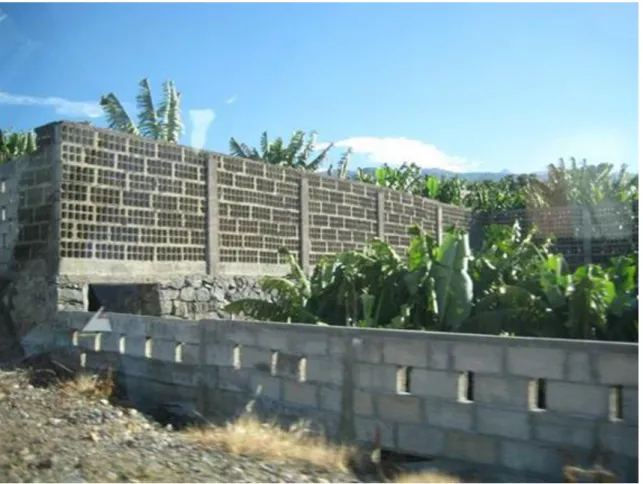
Figure 18. The disappearance and degradation oflandscape character. Banana plantations surrounded by a concrete fence. Tenerife, (photography of the author).
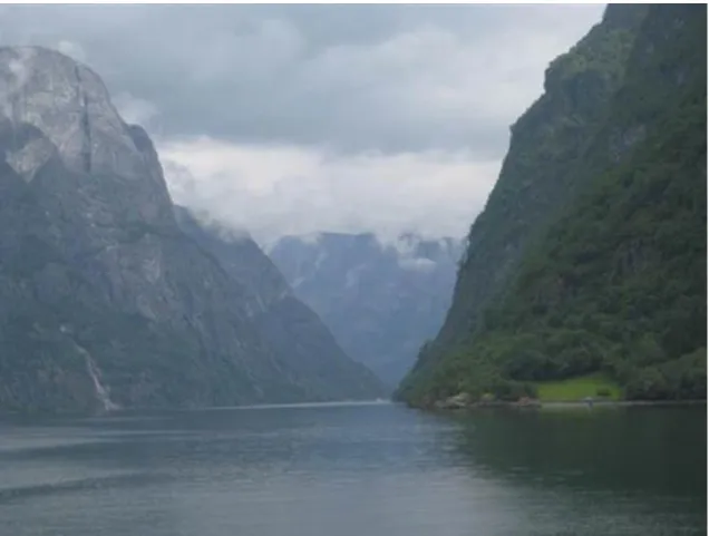
Figure 19. A naturallandscape character, that is probably difficult to destroy because of thesteepslopes.
SogneFjord, Norway, (photography of the author).
TheLandscapeManual defines several terms in addition tothe above,such as green surface anditselements,green surface systems, green areas, biologicallyactive surfaceand the concept of biologicalactivity value, but we disregard their detailedcitationandpresentation.
2.3. 2.3. Landscape planningandlandscape maintenance
Figure 20. Urban planners were too economic in planning green spacesin Athens, (photography of the author).
Figure 21. Parks in the United Kingdom are integral elements of the towns reminding us of naturalconditions,in this case ofapasture, (photography of the author).
Simplywe can saythatit is necessary to maintain the planned landscape.However, wemay assumethat the termlandscape planning is almost the same as landscape maintenance,since preparing theplanmeanscare in itself.
Let us see, then, what therelationship between thesetwo concepts is. The establishment and maintenance ofparks, green areas is an importanttask oflandscape planning and maintenance of denselybuilt-up areas.Figure 20shows an example of bad management, while Figure 21 presents afavourablesituation.
From the literature of the last centurylet us citeLanger, who pointed out in 1970that"landscape maintenance"
(Landschaftspflege) is nothing more thanappliedlandscape ecology.Leser(1976) considerslandscape maintenance as the basisoflandscape ecology. In Knauer‟s opinion(1981) landscape ecologyin practice is very similarto landscape maintenance. Landscape management, landscape planning must be based onlandscape ecology. Haber(1981) states thatlandscape planningis in reality mainlylandscape ecologicalplanning.
In the German literature, besides landscape maintenance, the termlandscape culture(Landeskultur) is also used.
This is an inter-relatedsystem oftechnical,infrastructuraland ecological measures based on social,economic andlandscape ecologicalbasis. This systemserves to preserveandimprove the naturalliving andproduction conditionsinthe culturallandscape, or any other areas of use.First of allitsaim is that human society shouldutilizethe humanenvironmentefficientlyand accordingly, develop it optimally. The world “culture” refers to cultivation and the "cultivation" of the landscape also means maintenance, so landscape maintenance is part of landscape culture.
Landscape maintenance, landscape protection, landscape architectureand the planning of greenareasare all subordinated totheconcept oflandscape maintenance (in German literature"Landespflege"). According to the German interpretation, thepractical and scientificpurpose of landscape managementis toprotect, maintain anddevelop the environment of human beings. Thecultural landscape, the areas of housing, industry, forestry, agriculture and recreationbelong also to the subject matter of maintenance.Thus, themaintenanceof space is a field of ecologicalspatial planning. The most important task falls within the scopeof ecology. Itsrole is to provide a balance between societyand theneeds oflandscapeecosystems,manifested as a balance between landscaperesources/capabilities and landscapeproductivity. Figure 22 and 23 show twoexamples of high quality landscape care. On the latterfigurewe seea good example for a keyfactor ofthelandscape structure.
Figure 22. A traditionallandscape.A good example fora carefullyandnicelydesigned andmaintenedlandscapethat preserveslandscape character. Salzburg, (photography of the author).
Figure 23. A cultural landscape. The elongated and narrow shapeand determines thelandscape structureof the island. Margit-sziget, Budapest. (Source:www.gyenesdias.info.hu)
The most importantoperationalareas oflandscape maintenancearethe maintenance andprotection of thenon-built- up areas. Thelandscapemust be “equipped”, protected, maintained anddevelopedto suit optimally the physical,psychologicaland socio-economic claims of thepeople, too. Landscape ecologicalstudieswith their landscape diagnosis methodactually provide a basis for carefullandscape planning, recommended actions and facilities to becarried out by landscape architecturein practice.
Figure 24. The tasks of landscape planning (after Finke, 1994).
Themost importantapplication areasof landscape planning are shown in Figure 24. The two areas that are theclosest tolandscape planning can be found on the leftside ofthe figure. Theaspects of nature conservation must be enforced in all landscape plans without exception, the validation of the purposes of recreation in nature follows from the essence oflandscape planning. All this is evident, however, regionally-specified target systemsmust be developed at all planning levels(Finke 1994).Thisfollowsfrom the nature ofthingsthat we musttake into accountall the aspectsof landscape ecology,the landscape forming factorsneed to be explored one by one. As a basic material, one or several maps (which cover the whole area) must be available for each ofthe landscape forming factors.(Several different thematicmaps are required in caseone landscape factor is analyzedfromdifferentpoints, e.g. soil textureandsoil typemaps.) Thenextstepof thismethodology is to evaluate thethematic map layers, e.g. for selectinggeological features to be protected, from the geologicalmap. Among other things, landscape potentialmaps are prepared as a result of the evaluation. The results are mainly natureconservation,landscape potential and recreationlandscape potential maps, asnature conservationand outdoorrecreation are considered.
Obviously, the landscape plan must be displayedand presented.Landscape plans can be landscapeframework plans or accompanyingplans indicating somemeasures. The objective of landscape planning is theprotection, care, maintenance, restoration and development of the natural management of landscapes, moreover the protection of certain landscape elementsas well as the planning of landscape structure.
The followingstep is landscape architectural activity based on theplanstaking into account the aspects oflandscaping maintenance activities, which could be regardedas the counter-pole oflandscape destruction. Its main objective isto“furnish” the free areas of the cultural landscape, as well as theirlong-term support. By the help of landscape architecture newproduction site conditionsandhabitats can be createdin the landscape. During the execution of the plan, landscape architecture uses natural materials.
GIStools help to accomplish the tasks oftoday's landscape maintenance, landscape planningand landscape architecture.The firststep in anycase is the landscape ecological survey and evaluation ofall thefactorsofthe landscapein general to be carried out at large scale. The capacity of thelandscape must be evaluated, namely the landscape potential must be identified. According to Bierhals(1978) the latter means the exploration of the consequences of loadability, sensitivity, performance capacity, landscape potential as well as the identification of ecologicalconflicts andrisks.
First apreliminaryresearch program, then “a tolerability” test is performed (i.e. examining how the landscape ecosystem tolerates the measure in question), and then we assess thecondition ofnatureand landscape.
Leser(1991) thinks that deficiencies and methodologicalgaps can be experienced between the theoretical ideas and the practical executions oflandscape maintenanceand landscape planning. In theory,we emphasize theimportance oflandscape ecologicalaspects, but in practice thelandscape ecologicalanalysis is oftenmissing.During landscape maintenanceand landscape planning it is verydifficult to analyze
thelandscapeecosystems atdifferent scalesfrom functionalpoint of view. Practical expertsusuallycapturethe visible landscape elements statistically. Theexploration of the material andenergy balance of the landscapeecosystemis a far more complex task.
2.4. 2.4. The framework system of landscape planning in Hungary
Landscape classification, the hierarchical system oflandscapesgives a theoreticalbasis for landscape planning on one hand and the other hand, itcanprovideimportantbasis forpracticalaspects on the other, namely it helps us in planning. It is mainly a theoreticalcommitment whether we should proceed from thesystem ofnaturallandscape unitsor from theadministrative units. In practicethe plan isusually, but notalways, made for someadministrative unit, e.g. for the area of a settlement.In spite of that it is important whether we try to adjust the planning to thelandscape borders orprocesses,whether we aware of the fact that even if a settlement occupies only asmall part of a micro-region, theprocesses may affect the whole landscape.
2.4.1. 2. 4. 1. About landscape classification in general
Landscape classification, namely the structure of the system oflandscapeat differentlevelsofhierarchy,has a long history in Hungaryand abroad. Mainly Europe must be understood to mean „abroad‟, because in the United States, landscape classification, the hierarchical structure ofthe landscape, does notplayacentral roleas in Europe,particularly in Germany. InGermany, inthe first half ofthe 20thcentury, more preciselyin themiddle of the century, the maintheoreticalaspects of landscape classification evolvedand themappingwork started (see e.g.
Schmithüsen1953). The earlylandscape classification mappingprogramswere madepurelyfor scientific purposes, no specificapplicationcriteriaarosein relation to them. The objective of the Germanlandscape classification was to producescientifically-basedmapsfor the preparation ofthe country'scontemporarynaturalgeography, and, after that, to distinguish separate socio-economic districts. We remark that in the middle ofthe last century,a number of studieswere published(see e.g. Haase 1979,Lang-Klug 1983,Leser1991) on the interpretation of theterritorial units at different scalesrelated tothe Germanlandscape classification and also on its theoreticalbackground.
Besides the requirement for deep theoretical scientific foundations, landscape classification is a verypractical question. This practicality first turns upwhen we are assigned aplanning task with economic and spatialrelevance. It may arise,for example, on what basis a particular state aid should be distributed: to municipalities, counties or physicalgeographicallyhomogeneous areas. (If thesupport isassigned to administrativeentities, this dilemma obviously does not present itself.) At nature conservationist, agriculturaletc.
applications, which are primarily practical scientificapplications, the spatial system of landscape classification is verywell suited, so it is recommendas a basis.However, our earlier notice is also valid,namely, that we usually prepare plans foradministrativeunits.
The German landscape classification system (naturräumliche Gliederung) (Schmithüsen 1953)was developed inthe middle ofthe last century. According to this, landscapes should be built successively from the smallest (from physical geographical point of view) homogeneousspatialunits. These smallestterritorialunitsarethe ecotopes-aswe know from Chapter3.3-(Troll 1939). Starting from the ecotopes and then getting into increasingly higherlevelson the hierarchy, we movefurther up to a higher dimension- sowe buildfrom the bottom. Landscape classification is typically made at medium- and small-scale, and that is why mostauthors indicate the deductivemethod, i.e. from the largerunitstowards thesmaller onesto the wayof landscape classification.
In spite of the above method, there are some who propose performing landscape classification with inductive methods, built from the smallest units-as we mentioned before (see e.g. Finke1994).Ifthis route is followed, it is clear that the smallestunits areprogressivelysummarized to higherhomogeneousunitsand then we reachthe largestunits. Naturally, you can alsocreate the landscape classification system using the inductivemethod. Those whoproposethe inductiveway(e.g. Neef1964a)think that the deductivemethodlacks seriousness. In their opinion, the deductivemethod actuallyfollows the morphographic principle, assuming that the samemorphographic properties are associated withthe same landscape ecologicalcharacteristics. In Neef‟s opinion, it is by no means true.We must notagreewith this view, as a deductive, top-downapproachnecessarily means morphographic- morphological way.If we think about the landscape classification of Hungary, our macro-regions were distinguished onmorphographicalbasis. Ata verysmallscale, morphography isthe most important differentiating factor.
At the same time, landscapes alsorepresent landscape potentials. Landscape potential in the generalsensedoes
view.According to this principle,thereis an opinion saying that alllandscape classifications are subordinated to practical purposes. This opinion is only acceptableto the extent, if we carry out the separation ofterritorial units from some practical point of view. Apart from this, however, there is apurely scientific, physical geographical landscape classification, whose creationisnotinfluenced by any practical aspects.
Schmithüsen(1953) states that there is a high degree ofagreement between the landscape classification map and themapof the potential naturalvegetation as far as borders are concerned.Thisagreement is particularly noteworthyin biggerdimensions.However, agreement very rarely occurs in smallerdimensions.
In Leser‟s opinion(1991), during the implementation ofthemethod ofthe landscape classification,isolatedlandscapes are separated thatrepresenttypesandcan be classified intoa hierarchicalsystem.
Thelandscape classification proceeds from base unitsof landscape studies, mainly visuallyperceivedlandscapefactors arereflected(e.g. topography,near-surfacerocks, soil, surface water, vegetation) and during theirseparation,we can considerindividual properties,too(e.g. slope,soil moisture, the naturalness of the vegetation).The method oflandscape classification follows the principle of physiognomysaying that certainfactors and properties of landscape express landscape management without quantifying it. Thus we can seethat during the development of the spatialstructure of landscape classification, differentauthorsemphasize thedominance of different landscape factors.
2.5. 2.5. The Historyof Hungarianlandscape classification
In his 1962 yearstudy, which has been cited several times already, Bulla gives an overview of the Hungarianlandscape classification and the previous Hungarian landscape researches. It assumesthat the Hungariannames of landscapesreflectdefinitegeographical contents. This againsuggests the fact thatthe aforementionedintuitive, subjective elementplays an important rolethrough the names of landscapein landscape classification. The instinctive popular recognition– Bulla writes -was followed by theexploration andscientificproof only later. We believethat thescientific establishment oflandscape classification ismuchmorethanthe adaptation of the instinctive popular recognition.
At the beginning of the 20thcentury,geographers started to deal with the landscape geography ofHungary and with the Hungarianlandscapes. This work is hallmarked by Lajos Lóczy and Jenő Cholnoky.Thefirst scientificresults of the complexlandscape researchis the Monograph of Lake Balatonprepared by Lóczy, thoughthefinalvolume,which was planned to have landscape geographical objectives,wasnot prepared(Lóczy 1920). This monograph was written nearly a hundred years ago.
Thegreat Hungariangeographer andpolitician,PálTeleki, also encouraged landscape explorationwork.However,despite the factthatTelekiformulated andsummarized thetasksoflandscape ecology, and that landscape researchwas an importanttrendin pre-warHungariangeography, only very fewsynthetic,summarizingworks were published. Lóczy(1918),Cholnoky(1928) andPrinz(1926,1936)madethe monographiccountry-descriptions, but as Bulla (1962) rightly points out, only Prinz‟s workcontaineddetailedlandscape analysis.
Thetwo otherworksmentionedabove reflect the geological-geomorphological trend of the first half of the last century. From thepre-warperiod, we can mentionthemonograph by Kogutowicz about Transdanubiaand theLittle Plain(1930, 1936), and some landscape-descriptions about the Great Hungarian Plain, Transylvania, the Carpathian Mountainsand the LitlePlain(Bulla1962).Theseareessentially landscape descriptions; we cannot meetlandscape maps and landscape classificationmapsas in the works of German geographers. A real landscape map was drawn by Zólyomirepresenting theGreat Hungarian Plain(1944).
After the Second WorldWar, theSoviet modelof scientificresearch was organized,and significantresearchcapacitybecome available for geography, including landscape research.Thevolumesof the BörzsönyandMátra(Lang 1955), Mezőföld(Ádám-Marosi– Szilárd,1959), Nyírség (Borsy, 1961), Cserhát (Láng, 1967),were published by the Geographical ResearchInstituteof theHungarian Academy of Sciences at the Academic Publishing in the series of "GeographicalMonographs". These landscape monographswere followed by additional volumes which did not study landscape geography.
In thelast decades of thelast century,the Geographical ResearchInstitute"researched intensively the whole country in the series called Landscape Geography of Hungary", so all the macro-regions-the macro-regions according to the landscape classificationvalidat the time. The regular anddetailed survey of the landscape geography of the countrytherefore beganin 1967 with the "Landscape Geography of Hungary” series, when the first volume,"The DanubianPlain (Marosi – Szilárd,1967)appeared. Since then-with the exception of theNorth
HungarianMountains-the landscape geographical survey of the whole countryhas been published: The TiszaPlain (Marosi – Szilárd,1969), TheLittle PlainandWest Hungarian Borderland (Ádám-Marosi,1975), theTransdanubian Hills(Ádám-Marosi– Szilárd,1981), the Transdanubian Mountains, (Ádám-Marosi–
Szilárd,1987) andthe Transdanubian Mountains,(Ádám-Marosi– Szilárd,1988).Thesevolumeswere also published by Akadémiai Kiadó, Budapest.
As the editorof the series, Márton Pécsi writes in the introduction tothe first volume ofthe series thatthis is the firstregular andcomplex survey ofthe currentterritory of the country.The previousworksdivided the historicalHungaryintolandscapes(Prinz-Cholnoky, 1936,andPrinz,1942).The Landscape Geography of Hungary series also offers new material in that it giveslandscape evaluation from other partsof the country. It evaluates the favourableor unfavourablecircumstancesof the economy.
Theoutstanding summarizingwork of the survey of the landscapesin Hungary is theKistájkataszter(Micro- regions of Hungary, Marosi-Somogyi,1990), published by theGeographical ResearchInstitute.
TheKistájkataszteris the best, most up to date basic work of the systematicprocessingof landscapeswhoselatestversionwas published in2010(Dövényi, 2010).
Thelandscape classification,the drawing of the borders of landscapes has to be the basis of anylandscape ecologicalsurvey. The brief overviewabove was absolutely necessaryto get to knowthe previous landscape geographicalexperiments. As we said, landscape planning must be carried out according to landscape classification.
The landscape classification of the country, and the concept ofdrawingthe borders of the landscapeschangedover time. Currently sixmacro-regions canbe distinguished in our country:(1) Great Hungarian Plains(2) Small Plain(3) Western Hungarian Borderland, (4) Transdanubian Hills(5) TransdanubianMountains, and(6), NorthHungarianMountains.
The system of landscape classification, the number and names ofthe macro-regionsconstantly changed in the past. In his work alreadymentioned,the Landscapes ofHungary, Gyula Prinz mentions two macro-regions in the present area of the country, the Great Hungarian Plain and the PannonianLand. He calls them “parts of the country”. Thesouthernboundaryofhistorical Hungary‟s northern part is called Mátra Forest by Prinz(Bulla,1962) in his book.Naturally, many otherexamplescould be cited from theworks ofpre-wargeographers. The 1950yearsschool curriculummentionsfourmacro-regions: The Great Hungarian Plain, The Little Plain, Transdanubia and theNorthern Mountains. As we can see, insteadof thelatter the name, North Hungarian Mountains was introduced.
The essence of the new approachof landscape classification isthatit handles really cohesive areas as units andtries toget rid of therootedapproach that generallythe Danube, the Tiszaand otherriversconstitutegenerallyborders of landscapes. It is obviousthat areas lyingon the rightand on the leftareareasthe samelandscape. Thus, the Danube lowland coversboth sides ofthe river, and itislikewise inthe casein therest ofthe rivers. Mezőföld is the part of theGreat Hungarian Plain, regardlessof the fact that it is located on theother side of theDanube. TheVisegrádMountainsbelong to theNorth Hungarian Mountains, despite the fact that thearealies in Transdanubia.
Hevesi, the author of one of the newest studies on the landscape classification of the Carpathian Basin (2001), describes a new approach, which neglectsnational boundaries, and presents a landscape classification system taking into account only the physical geographical units. He also reviews the history of landscape classification.
The landscape classification, which is the basis of the Micro-regions of Hungary, namely the table of contentsof the book, is presented forthe sake of informationinTable 1 the landscape classification map is shown on Table 1.The table makes the appliedhierarchyis clear:macro-regions,meso-regions,and micro-regions were distinguished.Micro-regiongroupshave not been determined, it is a bit confusing. Theproblem wasbridged in a way that thelandscapesgottwo-digitdecimalsigns. For example,in thecase ofZala Hills(3.4),4.3.11, 3.4.12, etc.
denotesthe unnamed Micro-regiongroups, etc.3.4.21. the next one,and so on.
Figure 25. The micro-regions of Hungary. (Dövényi, 2010.)
1. Alföld:
1.1. Dunamenti-síkság:
1.1.11. Vác–Pesti-Duna-völgy 1.1.12. Pesti-hordalékkúpsíkság 1.1.21. Csepeli-sík
1.1.22. Solti-sík 1.1.23. Kalocsai-Sárköz 1.1.24. Tolnai-Sárköz 1.1.25. Mohácsi-sziget 1.1.26. Mohácsi teraszos sík 1.2 Duna–Tisza közi síkvidék:
1.2.11. Gerje–Perje-sík 1.2.12. Pilis–Alpári-homokhát 1.2.13. Kiskunsági-homokhát 1.2.14. Bugaci-homokhát
1.2.15. Dorozsma–Majsai-homokhát