Application of GIS in Plant Protection
Presentation
TÁMOP-4.1.2.A/2-10/1-2010-0012
• Relation spatial database management tools
• Tasks of GIS systems GIS operations
GIS analyses
• Output options in GIS systems
• Application and creation of open webmaps
• Creation of digital maps, georeferencing
Network alignment, coordinate systems, projections
• Application of GNSS (Global positioning) systems
• GNSS corrections
• GNSS base station system(s)
• Measurement planning tools
• Realisation of GNSS measurement Processing measurement results
Tools of visualization, 3D possibilities
GIS Devices Used in Plant Protection
2
TÁMOP-4.1.2.A/2-10/1-2010-0012
• Access – operations
– Database management tools
• Relation model
– Basic tasks of GIS systems
• Data model
– Basic tasks of GIS systems I-II.
– Operations of GIS analysis
• Decision support
• Simulation
– Map formats, map servers
• Conversion
• Webmapping (Mashup maps)
Tools of Spatial Data Management
3
TÁMOP-4.1.2.A/2-10/1-2010-0012
• Aim of Database Management
• Types of Datamodel
• Relation Model
• Key, Functional Dependence
• Normal Forms
• Relationships
• Operations
Tools of Database Management
4
TÁMOP-4.1.2.A/2-10/1-2010-0012
• Schemes, creation of data models
• Visualization and storage of data together with relationships
• Entity, relation, feature
• Tasks of database management systems – Create database
– Execute query
– Privacy and safety of data – Integrity conditions
– Synchronization
Database
5
TÁMOP-4.1.2.A/2-10/1-2010-0012
• Grid
• Graph structure
• Entity: intersection
• Relation: edge
• Entity features
• Hierarchy
• Spectral graph : tree
• Relation
• The relation between the entities of a table is not given along with the data model
• Object-oriented
• The application of relation database softwares is normal in object oriented GIS softwares
Types of Data Models
6
TÁMOP-4.1.2.A/2-10/1-2010-0012
• Subset of table or direct product of feature type sets
• R (A1 ,A2 ……, An)
– A1 ,A2 ……, An attributes
– R name of relation – N degree of relation
• Entity type= relation
• Tables are connected with joint coloumns
Relation Data Model
7
TÁMOP-4.1.2.A/2-10/1-2010-0012
• The simplest subset of attributes, which identifies each line of the relation unambiguously
– Simple key – Complex key – Exterior key
• An attribute subset functionally defines another one, if exactly one value belongs to a value in the other one.
• Complete dependency, if it does not depend on its subsets
• Transitive dependency, if there is a functionally dependent attribute set.
Key, Functional Dependence
8
TÁMOP-4.1.2.A/2-10/1-2010-0012
• Exactly one attribute value in each line of the relation
Normalization – 1. Normal Form
9
Number Name Home DVDid DVDtitle
101 John Smith Keszthely 1001,3002 USA, Murder on the Orien Express
102 George Green Budapest 2008 Catch 22
103 Jane Smith Siófok 3002 Murder on the Orien Express
Number Name Home DVDid DVDtitle
101 John Smith Keszthely 1001 USA
101 John Smith Keszthely 3002 Murder on the Orien Express
102 George Green Budapest 2008 Catch 22
103 Jane Smith Siófok 3002 Murder on the Orien Express
TÁMOP-4.1.2.A/2-10/1-2010-0012
Normalization – 2. Normal Form II.
10
Number Name Home
101 John Smith Keszthely
102 George Green Budapest
103 Jane Smith Siófok
Number DVDid DVDtitle
101 1001 USA
101 3002 Murder on the
Orient Express
Number Name Home DVDid DVDtitle
101 John Smith Keszthely 1001,3002 USA, Murder on the Orien Express
102 George Green Budapest 2008 Catch 22
103 Jane Smith Siófok 3002 Murder on the Orien Express
TÁMOP-4.1.2.A/2-10/1-2010-0012
• 1. in NF, each secondary attribute completely depends on the key
Normalization – 2. Normal Form
11
DVDid DVDtitle
1001 USA
3002 Murder on the Orien Express
2008 Catch 22 Number DVDid
101 1001
101 3002
102 2008
103 3002
Number Name Home
101 John Smith Keszthely
102 George
Green
Budapest 103 Jane Smith Siófok
Number Name Home DVDid DVDtitle
101 John Smith Keszthely 1001 USA
101 John Smith Keszthely 3002 Murder on the Orien Express
102 George Green Budapest 2008 Catch 22
103 Jane Smith Siófok 3002 Murder on the Orien Express
TÁMOP-4.1.2.A/2-10/1-2010-0012
• 2. in NF, none of the secondary attributes depend on the key transitively
Normalization – 3. Normal Form
12
Number Name Home
101 John Smith Keszthely
102 George
Green
Budapest 103 Jane Smith Siófok
Sorszám DVDtitle
1001 USA
3002 Murder on the Orien Express
2008 Catch 22
Sorszám Name
101 John Smith
102 George
Green
103 Jane Smith
Name Home
John Smith Keszthely George
Green
Budapest Jane Smith Siófok Number DVDid
101 1001
101 3002
102 2008
103 3002
TÁMOP-4.1.2.A/2-10/1-2010-0012
• 1-1 Connectivity
• 1-N Connectivity
• N-M Connectivity
Tipes of Relationship
13
Student Sid
Sname
Examination Eid
Tid Sid Grade
Teacher Tazon Tnév 1
∞
1
∞
TÁMOP-4.1.2.A/2-10/1-2010-0012
• Union, section
• Descartes product
• Projection
• Selection
• Quotient
• Section
• Connection
• Natural connection
Relation operations
14
TÁMOP-4.1.2.A/2-10/1-2010-0012
• File manager, catalog – Set coordinates – Data layers
• Mapping
– Visualization, query – Analyses
• Tools
– Conversion – Analysis
Structure of Desktop GIS System
15
TÁMOP-4.1.2.A/2-10/1-2010-0012
• Vector data model
• Spaghetti model
• Network model
• Topologic model
• Raster model
• Hybrid model
• Vector
– Shapefile – Geodatasets
– DXF, DWG (CAD)
• Raster – Grid
• 2,5D-3D
– DEM-TIN
– Contour line, cloud of points, 3D Laserscanner formats
– SOLAP multidimensional datastructures
– Hyperspectral dataformats
GIS Data Models, Data Formats
16
TÁMOP-4.1.2.A/2-10/1-2010-0012
• Raster and vector data can be used together in hybrid systems.
– Hybrid Data Model: GoogleMaps
• MASHUP map: a map created from several inrernet or other sources (often integrating other applications (API)).
Hybrid Data Model, Mashup Webmap
17
MASHUP Hybrid map
TÁMOP-4.1.2.A/2-10/1-2010-0012
• Database operations
• Transformations
• Spatial representations of query
• Neighbourhood analysis
• Size definition
• Contraction, recoding, incorporation
• Overlay
• Buffer zone generation
• Modelling (relief model)
• Move, rotate, copy and paste, delete elements
• Add and delete, move cut-off point
• Edit existing features of cut-off points
• Transformation of line and poligon with sketch
• Panel poligon element
• Panel, trim, extend, cut line element
• Scale rate and cut element
• Proportional rendering of element geometry
• Simplify and generalize element
GIS Operations, Editing
18
TÁMOP-4.1.2.A/2-10/1-2010-0012
Generalization, Movement, Rendering of a Poligon
19
TÁMOP-4.1.2.A/2-10/1-2010-0012
• Digiltal Elevation Model (DEM) analyses – Slope
– Aspect – Visibility
• Analysis of networks – Traffic planning
• Edition, overlay
– Zone generation
GIS Analyses
20
TÁMOP-4.1.2.A/2-10/1-2010-0012
• Online decision support systems
– Spatial Decision
Supporting Systems - SDSS
– simulation possibilities
• Spatial, geostatistics
– spatial heterogeneity, clustering
– combination of info and info levels
• Simulation
– objects, events, processes
• Monitoring
– changes
• Model management
– feedback (monitoring) – model refinement
– validity
Decision Preparation, Spatial Modelling
21
TÁMOP-4.1.2.A/2-10/1-2010-0012
• Tasks of GIS systems – Data collection – Data storage – Query
– Analysis
– Visualization – Publication
• Database – Map– Model – Data
– Software – Hardware
– Developer, user – Processing
Basic Operations of GIS Systems I-II.
22
TÁMOP-4.1.2.A/2-10/1-2010-0012
• Video
– MASHUP Hybrid map
• Animation
Videos and Animations for Chapter 1.
23
TÁMOP-4.1.2.A/2-10/1-2010-0012
I. question
1. Select primary key.
2. Give functional dependency.
Tasks for Chapter 1.
24
Id Name Birthday
1-561211-1251 John Smith 27.12.2001.
2-881111-2514 George Green 23.11.1987.
1-331010-2314 Jane Smith 11.11.1970.
TÁMOP-4.1.2.A/2-10/1-2010-0012
II. question
1. Is the database in first normal form?
2. Is the database in second normal form?
3. Is the database in third normal form?
4. If not, transform all of them to the given form.
Tasks for Chapter 1.
25
Id Name Birthday
1-561211-1221 John Smith 27.12.2001.
2-881111-2514 George Green 23.11.1987.
1-331010-2314 Jane Smith 11.11.1970.
TÁMOP-4.1.2.A/2-10/1-2010-0012
III. question
create a ‘more-more’ relation with ‘one-more’ relation with the help of ‘shopping’, ‘shopper’ , ‘seller’ and ‘herbicides’.
(one shopper can buy from several sellers, one seller can serve more shoppers)
Shopper (Sid, Sname) Seller (Sid, Sname)
Shopping (Shoppingid, Sum, …)
Herbicides (Herbid, Herbname, Herbprice …)
Tasks for Chapter 1.
26
TÁMOP-4.1.2.A/2-10/1-2010-0012
• Layers and projects
• Create new map layer (point, line, poligon)
• Manage raster and vector layers
• Create a buffer zone
• Select
• Manage projections
• Visualization
• Scale dependent visualization
• Create map output
– Access to software: http://esri.com/aejee
Operations (ArcExplorer JEE)
27
TÁMOP-4.1.2.A/2-10/1-2010-0012
• ESRI MapServer
– http://geographynetwork.com
• Georgikon MapServer
– http://vektor.georgikon.hu
• AIR MapServer
– http://terkep.air.gov.hu/terkep
• Corine Land Cover 2000 Database
– http://fomi.hu/corine/clc2000_index.html
Used Data
28
TÁMOP-4.1.2.A/2-10/1-2010-0012
ESRI MapServer
– http://geographynetwork.com
29
TÁMOP-4.1.2.A/2-10/1-2010-0012
Georgikon MapServer
30
TÁMOP-4.1.2.A/2-10/1-2010-0012
Hungarian National Rural Network (AIR) MapServer
31
TÁMOP-4.1.2.A/2-10/1-2010-0012
Corine Land Cover 2000 database
32
TÁMOP-4.1.2.A/2-10/1-2010-0012
Layers and Maps
33
Access to software: http://esri.com/aejee
ESRI MapServer: http://geographynetwork.com
TÁMOP-4.1.2.A/2-10/1-2010-0012
EOV koordináták
• 519765.682 150407.097
• 519672.151 150417.697
• 519725.152 150353.472
• 519636.609 150370.308
• 519687.116 150302.966
• 519598.573 150318.554
• 519649.703 150252.459
• 519562.408 150268.671
• 519608.549 150200.705
• 519520.630 150216.917
• 519571.761 150150.198
• 519483.218 150165.163
• 519532.478 150096.574
Generation of Sample Points for GPS
34
Access to software, sample files and step by step description: http://esri.com/aejee
TÁMOP-4.1.2.A/2-10/1-2010-0012
Text File Generation - *.csv
35
TÁMOP-4.1.2.A/2-10/1-2010-0012
• Generation
– .csv (Comma Separated Values - Notepad)
– Shape File Generation(pl:
ArcExplorer JEE)
– View (pl: ArcExplorer JEE)
Shape File Generation
36
TÁMOP-4.1.2.A/2-10/1-2010-0012
View of Generated Points
37
TÁMOP-4.1.2.A/2-10/1-2010-0012
HOTLINK Weblink and Shape Files
38
TÁMOP-4.1.2.A/2-10/1-2010-0012
Add Raster Layer from MapServer
39
TÁMOP-4.1.2.A/2-10/1-2010-0012
Select Raster
40
TÁMOP-4.1.2.A/2-10/1-2010-0012
View on Raster Layer
41
TÁMOP-4.1.2.A/2-10/1-2010-0012
Add Vector Layer from Shape File
42
TÁMOP-4.1.2.A/2-10/1-2010-0012
Select Buffer Zone – Select Points
43
Buffer zone
TÁMOP-4.1.2.A/2-10/1-2010-0012
Give Buffer Zone on Point Like Objects
44
TÁMOP-4.1.2.A/2-10/1-2010-0012
Multiplicated Buffer Zone
45
TÁMOP-4.1.2.A/2-10/1-2010-0012
Multiplicated Buffer Zone on Different Layers
46
TÁMOP-4.1.2.A/2-10/1-2010-0012
• Select by attribute
• Select by query
• Select legend symbol
• Select by geography
• Select by spatial query
Selection
47
GIS operations
TÁMOP-4.1.2.A/2-10/1-2010-0012
Attributes of Field
48
TÁMOP-4.1.2.A/2-10/1-2010-0012
• Connected selection
– Table of attributes – Layer
Selection
49
TÁMOP-4.1.2.A/2-10/1-2010-0012
Selection by Database Management
50
TÁMOP-4.1.2.A/2-10/1-2010-0012
Selection by Legend Symbol
51
TÁMOP-4.1.2.A/2-10/1-2010-0012
Selection by Topology
52
TÁMOP-4.1.2.A/2-10/1-2010-0012
Selection by Spatial Query
53
TÁMOP-4.1.2.A/2-10/1-2010-0012
Projection
54
GISsettings
TÁMOP-4.1.2.A/2-10/1-2010-0012
Set up Projection
55
TÁMOP-4.1.2.A/2-10/1-2010-0012
Geographic Systems
56
TÁMOP-4.1.2.A/2-10/1-2010-0012
Eckert IV.
57
TÁMOP-4.1.2.A/2-10/1-2010-0012
Orthography
58
TÁMOP-4.1.2.A/2-10/1-2010-0012
Albert’s Equal Area
59
TÁMOP-4.1.2.A/2-10/1-2010-0012
View - Corine Land Cover 2000 Database
60
GIS web compilations
TÁMOP-4.1.2.A/2-10/1-2010-0012
Graduated Symbols
61
TÁMOP-4.1.2.A/2-10/1-2010-0012
CLC2000 Classes
62
TÁMOP-4.1.2.A/2-10/1-2010-0012
• Code Level 3,"Label Level1","Label Level2","Label Level3","RGB Color"
• 112,"Artificial surfaces","Urban fabric","Discontinuous urban fabric","255- 000-000"
• 121,"Artificial surfaces","Industrial, commercial and transport units","Industrial or commercial units","204-077-242"
• 141,"Artificial surfaces","Artificial, non-agricultural vegetated areas","Green urban areas","255-166-255"
• 142,"Artificial surfaces","Artificial, non-agricultural vegetated areas","Sport and leisure facilities","255-230-255"
• 211,"Agricultural areas","Arable land","Non-irrigated arable land","255- 255-168"
• 221,"Agricultural areas","Permanent crops","Vineyards","230-128-000"
• 231,"Agricultural areas","Pastures","Pastures","230-230-077"
242,"Agricultural areas","Heterogeneous agricultural areas","Complex cultivation patterns","255-230-077"
• 311,"Forest and semi natural areas","Forests","Broad-leaved forest","128- 255-000"
• 411,"Wetlands","Inland wetlands","Inland marshes","166-166-255"
412,"Wetlands","Inland wetlands","Peat bogs","077-077-255"
Part of Corine Land Cover Classes
63
TÁMOP-4.1.2.A/2-10/1-2010-0012
Draw Features Using Unique Symbols
64
TÁMOP-4.1.2.A/2-10/1-2010-0012
Scale Dependent Query
65
• Line:
– Scale range 1:7500 - 1:30000
• Point:
– Scale range above 1:15000
• Polygon:
– Scale rate above 1:7500
TÁMOP-4.1.2.A/2-10/1-2010-0012
Scale Dependent Query II.
66
TÁMOP-4.1.2.A/2-10/1-2010-0012
Layout
67
TÁMOP-4.1.2.A/2-10/1-2010-0012
• Traditional/digital map – Concept of scale rate – Georeferency
– Use of layers
• Mapping
– Different data sources
• Accessing maps online – Webmap
– Layers of webmap – Map compilation
Formats and MapServers
68
TÁMOP-4.1.2.A/2-10/1-2010-0012
• Not only the digital description of the content of a map managable by a computer (no need for sectioning, elements of real size, exact fitting, topology, often uses layers and objects).
• Primary data gaining methods – Measurement (GPS)
– Existing reports
Primary data collection methods usually create vector data.
• Secondary source
– Digitalization followed by automatic or manual vectorization
With secondary methods, in the case of georeferencing and vectorization, vector maps are creared. With secondary methods (scanning), if
georeferencing is not followed by vectorization, a digital raster map is created.
Creation of Digital Maps
69
TÁMOP-4.1.2.A/2-10/1-2010-0012
• Influencing factors for data validity – Source
– Geometric accuracy
– Accuracy of attribute data – Consistency of attribute data – Topologic consistency
– Completeness and relevance of data
Check Data Quality
70
TÁMOP-4.1.2.A/2-10/1-2010-0012
Online access to mapservers
– Search for soil type
• Hungarian National Rural Network (AIR) http://terkep.air.gov.hu/terkep/
– Search for map coverage
• Georgikon Mapserver http://map.georgikon.hu
– Search
• Nature Conservation Information System (TIR) http://geo.kvvm.gov.hu/tir
Online Accessibility of Mapservers
71
Webmaps
TÁMOP-4.1.2.A/2-10/1-2010-0012
• Web address
http://terkep.air.gov.hu/terkep/
• Service
– Public maps
• Load map: genetic soil map of Hungary, search soil type – Chernozem soil
• Select based on query results
Online Access to the AIR Map Collection
72
TÁMOP-4.1.2.A/2-10/1-2010-0012
Search for Soil Type
73
TÁMOP-4.1.2.A/2-10/1-2010-0012
• Web address
http://map.georgikon.hu
• Service
– Soil maps on the watershed of Lake Balaton, Hungary http://vektor.georgikon.hu/website/talajmap/viewer.htm
• Active Layer
– Adjacent section maps of Zala County, Hungary (zalaszh)
• Query
– Field: Telepules, Operator: =, Value: Zalaszentgrót – Add to Query String, Execute
• Select by query results
Georgikon MapServer on the Internet
74
TÁMOP-4.1.2.A/2-10/1-2010-0012
Search for Adjacent Section Soil Map
75
TÁMOP-4.1.2.A/2-10/1-2010-0012
• Weblink
http://geo.kvvm.hu/tir
• Service
– Open map
• Active layer, visibility (layers) – EOTR 10 net coupon
• Search
– For 32-212 1:10000 EOTR coupon – On active layer
Nature Conservation Information System
76
TÁMOP-4.1.2.A/2-10/1-2010-0012
Search on a Webmap
77
TÁMOP-4.1.2.A/2-10/1-2010-0012
• Public API (Application Programming Interface)
– Complex webmapping systems ensuring API on other websites and produce for reuse (a Google Maps with Google Maps API, YahooMaps , ESRI ArcIMS, GIS Server API)
• Important webmaps
– GoogleMaps
http://maps.google.com
– YahooMaps
• http://maps.yahoo.com
– Bing
• http://www.bing.com/maps
– Geoportal
http://geoportal.fr
Public Webmapping
78
TÁMOP-4.1.2.A/2-10/1-2010-0012
• Google web services
– http://picasaweb.google.com – http://youtube.com
– http://googlemaps.com
• Create website
– http://microsoft.com
• Web storage service
– http://ingyenweb.hu
Simple Online Publication of a Webmap
79
Website
MapServer
Picture
Video
Web service HTML
TÁMOP-4.1.2.A/2-10/1-2010-0012
• Steps of realization
– 1. Select topic
– 2. Create map, upload data
• a. Create a web album, upload images
• b. Upload video
– 3. Create website, embed map
– 4. Publish website
Create Project Website with Map
80
TÁMOP-4.1.2.A/2-10/1-2010-0012
• Video
– Buffer zone – GIS operations – GISsettings
– GIS web compilations – Webmaps
• Animation
Videos and Animations for Chapter 2-3-4.
81
TÁMOP-4.1.2.A/2-10/1-2010-0012
I. question
Find the characteristic soil type of Fehér County, Hungary on the AIR genetic soil map.
Tasks for Chapter 2-3-4.
82
TÁMOP-4.1.2.A/2-10/1-2010-0012
II. question
Create the shape file containing the following points (bp.shp) with the help of ArcExplorer JEE .
1. Parlament (Parliament building) 47.507, 19.046 2. Lánchíd (Chain Bridge) 47.499, 19.044 3. Mátyás-templom (Matthias Church) 47.502, 19.034
Tasks for Chapter 2-3-4.
83
TÁMOP-4.1.2.A/2-10/1-2010-0012
III. question
Find the following ‘Mashup’ map coverage and soil map with ArcExplorer JEE (or any other) software.
1. Add internet server
2. http://vektor.georgikon.hu Talajmap 3. http://geo.kvvm.hu Nitrat (90%
transparency)
Tasks for Chapter 2-3-4.
84
TÁMOP-4.1.2.A/2-10/1-2010-0012
IV. question
Open Atlas_Landuse.shp database at
http://geographynetwork.com with ArcExplorer JEE (or any other) software. Set projection ‘Eckert IV, SPHERE’ .
Tasks for Chapter 2-3-4.
85
TÁMOP-4.1.2.A/2-10/1-2010-0012
V. question
Open Atlas_Landuse.shp database at
http://geographynetwork.com with ArcExplorer JEE (or any other) software. Select a 20km buffer zone around the rivers of Hungary.
Tasks for Chapter 2-3-4.
86
TÁMOP-4.1.2.A/2-10/1-2010-0012
VI. question
Open any database at http://geographynetwork.com with ArcExplorer JEE (or any other) software, try the following functions
• One Symbol
• Graduated Symbols
• Unque Symbols
Tasks for Chapter 2-3-4.
87
TÁMOP-4.1.2.A/2-10/1-2010-0012
VII. question
Open any database at http://geographynetwork.com with ArcExplorer JEE (or any other) software, create a map
compilation (Layout) with the following elements:
• Image
• Text
• North sign
• Scale rate
• Legend
Tasks for Chapter 2-3-4.
88
TÁMOP-4.1.2.A/2-10/1-2010-0012
VIII. question
Open any database at http://geographynetwork.com with ArcExplorer JEE (or any other) software. Set visibility at least for 3 layers in different scale rates.
Tasks for Chapter 2-3-4.
89
TÁMOP-4.1.2.A/2-10/1-2010-0012
IX. question
Create a GoogleMaps map on any agronomy topic with at least 5 objects and inserted images. Send link via email.
Tasks for Chapter 2-3-4.
90
TÁMOP-4.1.2.A/2-10/1-2010-0012
• Coordinates are ordered to the points of an image or map.
• Base point systems – OGPSH
– Vertical surveyor milestones or landmarks – Horizontal surveyor milestones
– Integrated Geodesic Point Network (INGA)
• Cca. 2000 points of different measurement techniques, in several reference systems, with a new type of perpetuation. Aim: 4D
geodesy and sustainability.
• Georeferencing – Graphic
– Manual
Transformation, Georeferencing
91
TÁMOP-4.1.2.A/2-10/1-2010-0012
• GPS measurement: height above ellipsoid
• Height above sea level : geoidundulation is to be considered
• Distance between a point of the geoid (the true physical figure of the Earth) and the ellipsoid (representing the Earth’s figure), measured on the ellipsoid normal of the point
h = H + N
h height above ellipsoid H height above sea level N value of geoidundulation
Geoid Undulation
92
TÁMOP-4.1.2.A/2-10/1-2010-0012
• Geoid
– Surface of the oceans and seas if connected by
small channels under the dry land (Listing 1873) – its form depends on
gravitation and
centrifugal acceleration.
– The regular,
mathematically
describable body closest to the geoid is ellipsoid.
Geoid Undulation in Hungary
93
TÁMOP-4.1.2.A/2-10/1-2010-0012
• The area of Hungary is covered by 85
48000x32000m 100000 sections.
• The North-west EOV
coordinate of section 32 is (480000;160000).
• Section 32 431
– M 1:100 000 32 – M 1: 50 000 32 – 4 – M 1: 25 000 32 – 4 – 3 – M 1: 10 000 32 – 4 – 3 - 1
Uniform National Projection System (EOV-EOTR)
94
TÁMOP-4.1.2.A/2-10/1-2010-0012
Coordinate System of EOV:
• The starting coordinates have been placed 200km to the South and 650 km to the West. Thus, the Y coordinates are lower than 400, and the X
coordinates are always higher than 400, which means they are easy to distinguish.
Uniform National Projection System Coordinates
95
TÁMOP-4.1.2.A/2-10/1-2010-0012
• First leveling of Hungary was carried out based on the
1873-1913 Mediterranian datum level.
– Height of Nadap reference landmark: 173,8385 m.
• After World War II, sea level at Kronstadt as the basic
reference was used.
– Height of Nadap reference point:
173,1638, which is 0,6747 m
lower than it used to be applied in reference of Adriatic sea.
Vertical Network of Hungary (EOMA)
96
TÁMOP-4.1.2.A/2-10/1-2010-0012
• OGPSH (ETRS89-WGS84) → EOV
• EOV → OGPSH (ETRS89-WGS84)
– OGPSH (National GPS Network, Hungary)
– ETRS89 (European Terrestrial Reference System 1989)
– WGS-84 (World Geodetic System 1984 )
– EOV (Egységes Országos Vetület, Uniform National Projection)
– Access to software:
http://www.gnssnet.hu/letolt3.php
Transformation
97
TÁMOP-4.1.2.A/2-10/1-2010-0012
– Koordinates (φ, λ, h)
OGPSH ETRS89 - WGS- 84(European Terrestrial Reference System 1989 - World Geodetic System 1984 ) :
• Orient: 46,682803552 – 17,340250842 – 215,403
• Northwest: 46,685463630 – 17,345102758 – 220,276
– Koordinates (y, x, H)
EOV :
• Orient: 519404,937 – 150145,958 – 170,295
• Northwest: 519782,473 – 150433,483 – 175,171
Transformation
98
TÁMOP-4.1.2.A/2-10/1-2010-0012
Transformation– EOV → OGPSH
99
TÁMOP-4.1.2.A/2-10/1-2010-0012
Transzformáció – EOV → OGPSH
10 0
TÁMOP-4.1.2.A/2-10/1-2010-0012
Transformation– OGPSH → EOV
10 1
TÁMOP-4.1.2.A/2-10/1-2010-0012
Transformation – OGPSH → EOV
10 2
TÁMOP-4.1.2.A/2-10/1-2010-0012
• Georeference: location data of a raster image in the geodesic coordinate system.
• Methods:
– World file
– Header (GeoTiff, GeoJP2…)
– access to software:
http://frankl.comdesign.at/Geo/Georeg.html
Georeferencing
10 3
TÁMOP-4.1.2.A/2-10/1-2010-0012
Georeferencing with Two Points
10 4
TÁMOP-4.1.2.A/2-10/1-2010-0012
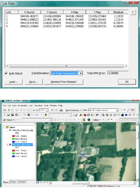
Georeferencing with More Points (RMS)
10 5
TÁMOP-4.1.2.A/2-10/1-2010-0012
• Georeferencing land profile WGS-84
– Coordinates (φ, λ, h):
• East corner : 46,682803552 –
17,340250842 – 215,403
• North-west corner:
46,685463630 –
17,345102758 – 220,276
Georeferencing
10 6
TÁMOP-4.1.2.A/2-10/1-2010-0012
Georeferencing – Set up Coordinates
10 7
TÁMOP-4.1.2.A/2-10/1-2010-0012
Georeferencing - World File Generation: *.jpgw
10 8
TÁMOP-4.1.2.A/2-10/1-2010-0012
• Georeferencing field profile EOV
– Coordinates (y, x, H):
• Eastern corner:
519404,937 – 150145,958 – 170,295
• North-western corner:
519782,473 – 150433,483 – 175,171
Georeferencing
10 9
TÁMOP-4.1.2.A/2-10/1-2010-0012
Georeferencing - Point with Known Coordinates
11 0
TÁMOP-4.1.2.A/2-10/1-2010-0012
Georeferencing – Word File Generation: *.jpgw
11 1
TÁMOP-4.1.2.A/2-10/1-2010-0012
• Load referated and to- be-referated images
• Create control points
• Select transformation
• Save changes
– Create help files – Create new raster
– Access to software (60 – day trial version):
http://www.esri.com/soft ware/arcgis/arcinfo
Graphic Georeferencing
11 2
Graphic georeferencing
TÁMOP-4.1.2.A/2-10/1-2010-0012
• With the help of 4
graphic control points
– Polinomial(1)
Graphic Georeferencing
11 3
TÁMOP-4.1.2.A/2-10/1-2010-0012
• Video
– Graphic georeferencing
• Animation
Videos and Animations for Chapter 5.
11 4
TÁMOP-4.1.2.A/2-10/1-2010-0012
I. question
which OGPSH points are used by the EEHHTT transformation if applied for Galyatető, Hungary?
Tasks for Chapter 5.
11 5
TÁMOP-4.1.2.A/2-10/1-2010-0012
II. question
Digitalize any map sheet with the help of a scanner, georeference it with 3 reference points with the GEOREGARCVIEW software.
The necessary coordinates can be obtained from mapservers (eg. Googlemaps).
Tasks for Chapter 5.
11 6
TÁMOP-4.1.2.A/2-10/1-2010-0012
III. question
Digitalize another map sheet overlapping the previous one with the help of a scanner. Georeferate with 3
reference points with the help of GEOREGARCVIEW
software. Open it together with the georeferated file of the previous task with ArcExplorer JEE (or any other) and check its accuracy.
The necessary coordinates can be obtained from mapservers (eg. Googlemaps).
Tasks for Chapter 5.
11 7
TÁMOP-4.1.2.A/2-10/1-2010-0012
• Online correction: GNSS (Global positioning) systems – Navstar GPS
– Glonass – Galileo ...
• GNSS corrections, GNSS base station system(s)
• Measurement planning devices
• Realization of GNSS measurement
• Process measurement results
• Tools for visualisation, 3D
GNSS Systems
11 8
TÁMOP-4.1.2.A/2-10/1-2010-0012
• Basic theory of global positioning
• GNSS systems – GPS
– Glonass – Galileo – BeiDou
• GNSS correction – GBAS
– SBAS
• Online correction
Global Navigation Satellite Systems
11 9
TÁMOP-4.1.2.A/2-10/1-2010-0012
• The coordinates of 3 satellites at a given time are needed.
• If time can be measured accurately, then wave spread speed and the time will help calculate how far we are from the
satellite.
• In the case of 1 satellite, it will give a sphere surface.
• If there is a connection with 2 satellites, then we are on the sphere of both
satellites. The section of the two spheres is a circle.
• The section of the sphere of the third
satellite and the circle will be two points, one of which can always be excluded (eg.
Points far from the earth surface).
Global Positioning System (GPS-GNSS)
12 0
TÁMOP-4.1.2.A/2-10/1-2010-0012
• Orbit data errors of satellites, accuracy of clock signal
• Change in wave spread speed
• State of the ionosphere (measurement using several frequencies)
• Characteristics of the atmosphere (temperature, pressure, humidity, other phenomena
• Wave spread, DOP (Dilution of Position)
• Environment of GPS sensor (shadowing, coverage)
• Electromagnetic noises in the environment
• Deliberate disturbance – GPS Jamming
– GPS Spoofing – GPS Meaconing
Factors Influencing Measurement Accuracy
12 1
TÁMOP-4.1.2.A/2-10/1-2010-0012
• The GPS system consists of three main sub systems:
– Space segment (satellites),
– User system (sensors and services) – Control segment (terrain control and
monitor stations)
GPS Segments
12 2
GNSS system
TÁMOP-4.1.2.A/2-10/1-2010-0012
• Selective Ability
– The change in accuracy when SA (disturbance) was turned off on 2. May, 2000.
• Global Performance Assessments
– http://www.schriever.af.m il/Gps
Selective Availability, Global Perf. Assessments
12 3
TÁMOP-4.1.2.A/2-10/1-2010-0012
• NAVigation Satellite Timing And Ranging Global Positioning System
• 1973
• First satellite launched: 1978
• Official system services from 1995.
• GPS SUPPORT CENTER
• USA MINISTRY OF DEFENCE
• NAVIGATION CENTER
Navstar GPS
12 4
http://gps.losangeles.af.mil http://www.schriever.af.mil
http://www.navcen.uscg.gov
TÁMOP-4.1.2.A/2-10/1-2010-0012
• GLONASS system
– 24 satellites, 3 orbit levels, 120 degree angle
– 8 satellites on each plane, within the same distance from one another, 45 degree width difference.
– A 19100-km orbit
– Time period: cca. 11 óra 15 perc
– Different frequency for each satellite.
Glonass
12 5
http://www.glonass-ianc.rsa.ru
TÁMOP-4.1.2.A/2-10/1-2010-0012
• 27 working and 3 spare satellites on 3 orbit
planes
• 23 616-km radius orbit
• Integrity
– Integrity signs will also be supplied by Galileo
satellites.
– At least 2 satellites above 25 degrees
– Alarm time: 6s
Galileo
12 6
http://www.giove.esa.int
TÁMOP-4.1.2.A/2-10/1-2010-0012
• Beidou-1 satellites and their launch time
– 1A (31. October, 2000.) – 1B (21. December, 2000.) – 1C (25. May, 2003.)
– 1D (3. February, 2007.)
• Beidou (Compass)-2
– M1 (14. April, 2007.) medium height orbit
– G2 satellite (15. April, 2009.) – G1 satellite (16. January, 2009.) – G3 satellite (2. June, 2010.)
• Complete second generation system: 27 MEOs, 3 IGSOs, and 5 GEOs
– Would consist of 5 high orbit and – 30 medium height orbit satellites.
BeiDou - Compass
12 7
http://www.beidou.gov.cn
TÁMOP-4.1.2.A/2-10/1-2010-0012
• Better quality of GPS reception; provided by the mobile service provider.
– Data exchange between the GPS in the phone and the server of the provider.
– Resource consuming calculation is carried out by the server of the provider.
AGPS (=Assisted GPS), GPRS Coverage
12 8
TÁMOP-4.1.2.A/2-10/1-2010-0012
• Better GPS reception provided by the mobile service provider.
– Data exchange between the GPS in the phone and the server of the provider.
– Resource consuming calculation is carried out by the server of the provider.
AGPS (=Assisted GPS), GPRS Coverage
12 9
https://www.vodafone.hu/lefedettsegi-terkep http://www.telenor.hu/internet/tudnivalok/lefedettseg
http://www.t-mobile.hu/lakossagi/mobil_szelessav/hasznos
GPRS Coverage
• Vodafone
• Telenor
• T-Mobile
https://www.vodafone.hu/lefedettsegi-terkep
http://www.telenor.hu/internet/tudnivalok/lefedettseg
http://www.t-mobile.hu/lakossagi/mobil_szelessav/hasznos
TÁMOP-4.1.2.A/2-10/1-2010-0012
• CSD (Circuit Switched Data)
– Line switched mobile internet - 9,6 kbit/s - 1G
• GPRS (General Packet Radio Service) – Package - 115 kbit/s - 2G
• EDGE (Enhanced Data Rates for GSM Evolution) – reinforce GPRS - 236 kbit/s-os (112-400) - 2,5G
• 3G
– third generation mobile network, videocall included 384 kbit/s - 3G
• HSPA (High-Speed Downlink/Uplink Packet Access)
– Theoretic data transfer speed of HSDPA can be, depending on device and coverage, up to 21 Mbit/s – 3,5G
• 4G LTE (Long Term Evolution) – 1Gbit/s - 4G
Mobil Internet Standards
13 1
TÁMOP-4.1.2.A/2-10/1-2010-0012
Navigation
13 2
TÁMOP-4.1.2.A/2-10/1-2010-0012
navigation, Route on Mobile Phone (2008)
13 3
TÁMOP-4.1.2.A/2-10/1-2010-0012
• Absolute – relative measurement planning – Geodesic accuracy
– GIS accuracy
– Navigation accuracy
• Aims:
-higher accuracy -higher integrity -lower downtime -SoL (Safety of Life)
Correction Systems
13 4
TÁMOP-4.1.2.A/2-10/1-2010-0012
GPS Position Errors
13 5
GPS (m) DGPS (m)
Clock inaccuracies 1,5 0
Shifts in the satellite orbits 2,5 0
Ionospheric effects 5 0,4
Tropospheric effects 0,5 0,2
Multipath effect 0,3 0,3
Calculation- und rounding errors 0,6 0,6
TÁMOP-4.1.2.A/2-10/1-2010-0012
The Theory of Differentational Correction
13 6
TÁMOP-4.1.2.A/2-10/1-2010-0012
Typical accuracy of GPS Measurement
13 7
Measurement Processing Code/phase Accuracy Navigation Absolute Real time Code
measurement
~10m
DGPS Relative Real time Code
measurement
~1m
Static Relative Offline Phase
measurement
~1mm Kinematic Relative Offline Phase
measurement
~1cm
RTK Relative Real time Phase
measurement
~1cm
TÁMOP-4.1.2.A/2-10/1-2010-0012
• Post procession
– Absolute : tracklog – DGPS: data collection
– Relative : high accuracy coordinates
• Real time
– absolute: navigation – DGPS: line feed
– Relative : alignment, field works
Type of Measurement (Correction Method)
13 8
TÁMOP-4.1.2.A/2-10/1-2010-0012
• Single Base
– Accuracy falls further from base
• Several bases
– Accuracy not homogenious
• VRS - Virtual Reference Stations
– Accuracy homogenious
– Accuracy of system changes just a bit if one station is unavailable.
Field Correction
13 9
TÁMOP-4.1.2.A/2-10/1-2010-0012
Trimble VRS System
14 0
TÁMOP-4.1.2.A/2-10/1-2010-0012
GPS –Glonass Trimble VRS Receivers in Hungary
14 1
TÁMOP-4.1.2.A/2-10/1-2010-0012
VRS for Agriculture
14 2
TÁMOP-4.1.2.A/2-10/1-2010-0012
• Traditional RTK GNSSnet
• Network RTK GNSSnet
– NtripCaster IP address, port: 84.206.45.44:2101 – http://gnssnet.hu
GNSSnet Bases and VRS System in Hungary
14 3
TÁMOP-4.1.2.A/2-10/1-2010-0012
• Geotrade GNSS coverage
– Host:
www.geotradegnss.hu – Port: 2101
– http://www.geotrade.hu/
geotradegnss
Geotrade GNSS System
14 4
TÁMOP-4.1.2.A/2-10/1-2010-0012
• Georgikon RTK coverage
• DGPS for the whole country of Hungary
– http://gnss.georgikon.hu – 193.224.81.88:2101
Single Base System – University of Pannonia, Hungary
14 5