ANDREA POZSGAI, ALEXANDRA PUSZTAI-EREDICS, GÁBOR BARANYAI, TIBOR LENNER
THE CONNECTION BETWEEN PUBLIC LIGHTING MODERNISATION AND LIGHT POLLUTION:
THE DUNAÚJVÁROS PATTERN
Eötvös Loránd University (ELTE) BDKP, Department of Geography, Szombathely, Hungary
E-mail: pozsgai.andrea@sek.elte.hu
Abstract
Proper street lighting has psychological, ecological and economic functions.
Not only does it provide safety in settlements at night, but it also makes streets friendlier. Inadequate quantity and quality of street luminaries can cause troubles in the ecosystems of settlements. Public lighting management is the responsibility of local governments, and therefore it matters how much the operation and maintenance burden the budget. The modernisation of the obso- lete street lighting system and the installation of a reliable and energy-saving (cost-effective in the long run) system is taking place in more and more places.
Large cities (domestic cities with county rights) deserve special attention due to the concentration of the population, functions and through them the concen- tration of environmental impacts.
Keywords: light pollution, public lighting,
https://doi.org/10.33041/ActaUnivEszterhazyBiol.2021.46.125
POZSGAI ANDREA, PUSZTAI EREDICS ALEXANDRA, BARANYAI GÁBOR, LENNER TIBOR
A KÖZVILÁGÍTÁS-KORSZERŰSÍTÉS ÉS A FÉNYSZENNYE- ZÉS KAPCSOLATA DUNAÚJVÁROS PÉLDÁJÁN
Eötvös Loránd Tudományegyetem (ELTE) BDKP, Földrajzi Tanszék, Szombathely
Összefoglalás
A megfelelő közvilágításnak élettani, ökológiai és gazdasági funkciói is vannak.
Nemcsak biztonságot nyújt a településen éjszaka, de barátságosabbá, ottho- nosabbá is teszi az utcákat. A nem megfelelő mennyiségű és minőségű utcai lámpatest működése során zavaró tényezőként jelentkezhet a fényszennyezés a településekhez köthető ökológiai rendszerekben. A közvilágítás fenntartása az önkormányzatok részéről kötelezően ellátandó feladat, ezért nem mindegy, hogy az üzemeltetés és a karbantartás mennyivel terheli meg a költségvetést.
Az elavult közvilágítási rendszer modernizálása, egy megbízhatóan működő, energiatakarékos (hosszú távon költséghatékony) rendszer kiépítése egyre több helyen lezajlik (lezajlott). A nagyvárosok (hazai viszonylatban a megyei jogú városok) a népesség, a funkciók és ezeken keresztül a környezeti hatá- sok koncentrációja miatt is kiemelt figyelmet érdemelnek. A tanulmányban egy magyarországi iparváros (Dunaújváros) közvilágítás-korszerűsítés előtti és utáni állapotát vizsgáltuk meg. Az elemzésbe bevont város éjszakai fénykibo- csátását a Radiance light trends webes alkalmazás segítségével elemeztük, ezt követően statisztikai kiértékelést végeztünk.
Kulcsszavak: fényszennyezés, közvilágítás
Material and methods
The night light emission of the city included in this study was analysed using the web application ‘Radiance light trends’ (https://lighttrends.lightpollutionmap.
info/). The information available on the platform come from two satellite sen- sors. Between 1992 and 2013 the data were transmitted by the Operational Linescan System of Defense Meteorological Satellite Program (DMSP) satelli- tes, and since 2012 they have been provided by the Earth Observation Group, NOAA National Geophysical Data Centre System relying on the records of the Visible Infrared Imaging Radiometer Suite (VIIRS DNB) instrument. Both inst- ruments scanned the entire Earth (at night), but the DMSP moved typically from above at about 8.30 p.m., while the VIIRS DNB much later, at around 1.30 a.m. The observation of night lights was not the primary goal of the DMSP, so the data records between 1992- 2013 had several deficiencies. The instrument was not calibrated, and for this reason the results were displayed as ’digital numbers’. The spatial resolution of the satellite was several kilometres, and it was actually larger than the pixels displayed by the application. In city centres, satellite data are often ’saturated’ (too bright for measurement). The VIIRS DNB is the first satellite to be deliberately designed to represent ’human lights’ wor- ldwide, making it a significant advance over the DMSP. The satellite resolution is approximately 750 metres (or 0.5 square kilometres). These data are projected onto a grid, so in some places (especially at large latitudes) the pixels appear in finer detail than what the satellite can virtually see. The instrument measu- res light in the spectrum range of about 500-900 nm. This is not the same as human vision, which operates at 380-780 nm. Satellite data are therefore less sensitive to white light than the human eye, and they are sensitive on the inf- rared wavelength that the human eye is not able to see. It explains that when settlements/territorial units change from orange, high-pressure sodium lamps into white LEDs, satellites often indicate a decrease in brightness even when one perceives white LEDs brighter. The information provided by VIIRS DNB’s gives the opportunity for a detailed, quantitative assessment of the changes in the distribution and intensity of artificial light. Night light data can report a lot of interesting aspects, but it is important to keep in mind what they exactly mean.
Nor should it be forgotten that many factors can distort the data like snow covers, water surfaces, vegetation depending on species and density, and fires which can cause temporary strong light emissions. Patterns of change in night lighting are becoming increasingly complex, especially in industrially developed areas and in lands with different natural geographical conditions. Emissions observed in a given area vary from month to month for several reasons. To some extent and in the long run it can be attributed to the actual changes of built-in lighting, however, in a shorter period of time several other reasons can affect the value of radiation.
Results
Brief introduction of the sample area
Dunaújváros, a ’made city’, was created as a result of a political decision and was developed from a central political will into a medium-sized city with county rights. All this fundamentally influenced and determined the construction of the city, its image, structure, and morphology in general. The city differs greatly from Hungarian mid-sized towns and cities in terms of both construction and structure, - one might say – it is much simpler or scantier. Considering that it was designed on the socialist model, the construction of Dunaújváros is diffe- rent from cities with county rights in three aspects. They appear in horizontal closure, vertical setup, and the number and ratio of development types. First of all, horizontal closure is very little in Dunaújváros, in fact, only multi-level enclosed development typifies the downtown parts built in the 1950’s. In contrast, the vertical setup of development is outstanding, i.e. the proportion of multi-storey residential buildings is high. Data of the census of 2011 show that 30,1% of residential buildings are blocks of flats in the city, mainly with three or four storeys. It is the highest ratio among Hungarian cities with county rights, even higher than in Budapest. The third characteristic of construction is that only six of the development types of Hungarian cities can be found in Dunaújváros (csaPo, 2004). There is no ’fork-like’ multi-storey condominium construction, while the rustic ’comb-shaped’ arrangement is represented only by three old cottages in the centre of the former village of Dunapentele. In addition, of the six types that occur, multi-storey blocks and family houses are absolutely common, with a combined proportion of about 80%. In this respect, it totally resembles Tatabánya, a city with a similar past (csaPó and lenneR, 2013).
In Dunaújváros, one of the ruling types is multi-storey block construction. In fact, with the exception of the former settlement, Dunapentele, the other parts of the city can be characterised by this way of development. In terms of area coverage, however, family house construction is the most significant. It occurs almost only in the Dunapentele district, where it is dominant.
The most important parameters of the program completed in 2015
In Dunaújváros, before the multi-stage modernisation there was a public light- ing system made up of sodium lamps. Regarding our study, it is interesting that in the districts affected by the modernisation of 2015, 4395 luminaries were operated, of which 1800 were replaced. The expected built-in performance and accordingly the cost savings after the project were around 35%. The result divided the public, with many saying visibility actually deteriorated. The work was carried out on 88 of the city’s 332 streets, but there were significant differ-
ences between parts of the city. It can be presumed that the designers intended to replace as many luminaries as possible in the densely populated, multi-sto- rey, block-built up areas (Barátság-, Dunasor-, Belváros-, Dózsa-, Technikum-, Béke-, Róma Districts. In practice, this meant that in the largest zone built-in with family houses (e.g. Újtelep), they only renewed the public lighting of the busiest routes.
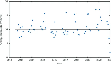
If we examine the extent of light pollution in the whole administrative area of the settlement, 52,67 km2 in extent (ksH gazetteeR, 2019), we cannot see any variation from 2012 to the present day (Figure 1). For the figure we exam- ined the mean radiance in the rectangle with the extreme coordinates: 18.894°, 46.915° and 18.964°, 46.981°. The horizontal lines represent the mean value before and after the remodelling. There is no significant change in the mean value.
Figure 1: Average radiation measured in Dunaújváros from April 2012 to December 2020 on a monthly basis. (source: own editing based on NOAA National Geophysical Database
Centre)
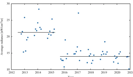
We can see the positive effect of lighting modernisation implemented in 2015 in Figure 3. Concentrating on the densely populated parts of the city (Fig.
2B), which occupies about 13 km2, a decreasing trend can be observed in the average monthly radiation rate. Based on the completed Student test, the dif- ference between the average monthly radiation before and after 2015 is signif- icant.
It is likely that the industrial establishments in the southern part of the city (red areas in Figure 2) are significant light emission sources, which cause a slight increase in the monthly radiation of the whole area of Dunaújváros year by year (Figure 1).
Figure 2: Light emission maps of Dunaújváros
A) Whole area. Left side: September 2014, right side: September 2016. (source: NOAA National Geophysical Database Centre). B)Densely populated parts of Dunaújváros. Left
side: September 2014, right side: September 2016. (source: NOAA National Geophysical Database Centre)
Figure 3 displays the variation of the mean radiance in the rectangular area with the corner coordinates of: 18.911°, 46.956° and 18.948°, 46.969°. The mean values represented by the horizontal lines differ significantly. Thus the positive effect of the replacement of luminaries in the settlement is demonstrated.
Figure 3: Average monthly radiation in the densely populated region of Dunaújváros from April 2012 to December 2020. (source: own editing based on NOAA National
Geophysical Database Centre)
Acknowledgement
The project is supported by the European Union and co-financed by the European Social Fund (Grant no. EFOP-3.6.2- 16-2017-00014; Development of international research environment for light pollution studies).
References:
csaPó, T. (2004). Néhány gondolat a hazai városok beépítéséről. [Thoughts on the building-up of Hungarian towns and cities]. Területi Statisztika. [Regional Statistics], 7(4), 332–351. Budapest
csaPót. – lenneRt. (2013). Tatabánya településföldrajza. [Settlement geography of Tatabánya]. FRISNYÁK S. – GÁL A. (szerk.). Kárpát-medence: természet, társadalom, gazdaság. [FRISNYÁK S. – GÁL A. (ed.). Carpathian Basin: nature, society, economy.], István Bocskai Grammar School of Szerencs and the Institute of Tourism and Geography, Nyíregyháza College, 289–303. Nyíregyháza-Szerencs
csaPót. – lenneRt. (2015). Dunaújváros településföldrajza. [Settlement geography of Dunaújváros]. Tésits R. – Alpek B. L. (szerk.) A mi geográfiánk: Tóth József emlékezete. [TÉSITS R.- ALPEK B.L. (ed.). Our geography: In memory of József Tóth.], Publikon Publisher, 527–537. Pécs
ksH gazetteeR (ksH HelységnévtáR): https://www.ksh.hu/apps/hntr.main [Date accessed 01/06/2020]
ModeRnisation oF PuBlic ligHting in dunaúJváRos (Közvilágítás korszerűsítése Dunaújvárosban): https://kozvilagitas.dunaujvaros.hu/ [Date accessed 29/05/2020]
Radiance ligHt tRends: https://lighttrends.lightpollutionmap.info/ [Date accessed 01/06/2020]