Introduction
It has been sixty years since the productivist paradigm emerged as a possible solution to food insecurity (De Schutter, 2014). The productivist model was supported by institutions worldwide due to the alarmist discourse of the demographic explosion, which was linked to the widespread hunger in developing countries. It entails the ‘progress’ engendered in the process conventionally called the ‘Green Revolu- tion’, based on mechanisation and the intensive use of agro- industrial inputs, natural resources, genetically improved seeds, irrigation, and chemical fertilisers (Borlaug and Dowswell, 2003). The advance of the model was translated into, on the one hand, the implementation of a series of tech- nological innovations to improve the productivity perfor- mance of agriculture and, on the other hand, the subsequent insertion of agriculture into the agro-industrial complex.
In Brazil, the productivist model was implemented dur- ing the second half of the 20th century, when the State began to intervene in the agriculture and husbandry sectors through policies aimed at reducing production costs, stabilising pro- ducers’ income and the granting of credit. Between 1960 and 1970, the State increased its efforts to promote the modernisa- tion of agriculture by incorporating the technological package imposed by the Green revolution, associated with tax incen- tives and easy access to means of production. Politically, the 1960s and 1970s were marked by the military dictatorship.
During this period, civil society representatives linked to fam- ily farming had no space in the public arena to discuss and build together with public managers, policies for their social
category (Grisa, 2012). Policies in this period had a triple selective character: they (1) were targeted at medium and large farmers; (2) had an export-oriented character; and (3) encour- aged the expansion of agribusiness (Guedes Pinto, 1978).
Throughout the second half of the twentieth century, socioeconomic inequalities and interregional disparities became more evident in Brazil (Prado Junior, 1981; Furtado, 1997). Geographically, uneven development intensified in the 1950s, due to the intensification of industrialisation that took place in the southeast and south regions, which trig- gered rapid urbanisation, whose corollary was the emptying of the rural areas (Baeninger, 2003).
The 1990s were marked by political and economic changes in the agrarian conjuncture, given the advance of economic neo-liberalisation. The new strategies included reducing the State’s intervention, deregulation of economic activities, pri- vatisations of State-owned companies, liberalisation of mar- kets, etc. (Lopes et al., 2011; Sallum Jr., 2003). During this period, the Southeast region was responsible for contributing more than 58% to the Gross Domestic Product and the South region for more than 17%, both regions accumulating more than ¾ of the wealth produced in the country (IBGE, 2010).
Despite the abstention from the State, the possibilities rendered in a re-democratisation pushed representatives from civil society and small rural producers to demand specific policies for the category (Grisa, 2012). In the light of increasing social movement’s pressure, the State rebuilt institutions that had been dismantled and started implement- ing a new generation of agrarian policies targeted at family farmers and female rural workers (Schneider, 2003). This set Emily Aparecida Ferreira BRANDÃO *,** and Stephan RIST *,***
The agrarian space of the Brazilian semi-arid region:
the dichotomies between the space of irrigated agriculture and the space of traditional agriculture
There is a relevant debate in the literature regarding the influence of the State in the production of space. The State was the main agent of the production of the agrarian space in the Brazilian semi-arid region, which is characterised by the territorialisa- tion of two contrasting food systems: the irrigated productive model and the traditional family farming model. This study inves- tigates the extent to which the spatial and sectoral selectivity of public policies has interfered in dichotomous agrarian space.
The agrarian space is analysed on two spatial scales, the municipal and the local. On the municipal scale, we have selected the municipalities of Petrolina and Casa Nova. The local scale, by contrast, refers to spatial fragments of these municipalities, where food systems spatially manifest themselves (modern irrigated and traditional rainfed agriculture). The results show that until 1980, public policies favoured the development and consolidation of modern irrigated agriculture in selected spatial frag- ments. This was due to public investments in irrigation, transport, communication and energy infrastructure, facilitated access to land, technical assistance and agronomic engineering services. From 1990 onwards, policies have become inclusive, aimed at the Family Farmers social group. Policies have entailed local solutions for access to water, contextualised technical assistance, alternative markets, income stabilisation for family farmers and improvement in food production and consump- tion. However, despite the inclusion of family farming in the agrarian structure, imbalances of power remain among the food systems, highlighting the great contradiction brought about by these public policies.
Keywords: food system; public policies; fundo de pasto communities; irrigated agriculture JEL classifications: Q15, Q20
* Institute of Geography, University of Bern, 3012 Bern, Switzerland. Corresponding author: emilyfbrandao@gmail.com
** Centre for Development and Environment, University of Bern, 3012 Bern, Switzerland
*** UNESCO Chair for Sustainable Mountain Development, University of Bern, 3012 Bern, Switzerland.
Received: 29 September 2020, Revised: 15 November 2020, Accepted: 17 November 2020
of policies prioritised local development and aimed at sta- bilising the family farming food system. Most new policies were institutionalised during the government of former pres- ident Luiz Inácio Lula da Silva (2003–2011). However, the asymmetries between macro-regions have not been reduced, since the Midwest, North and Northeast regions together, which comprise more than 82% of the country’s territory, and where more than 43% of the population live, contrib- uted only with 27.4% to Brazilian GDP (IBGE, 2010). Thus, the inequalities that persist – on different scales, between rural and urban areas, between macro-regions and micro- regions – have been the result of the unequal advance of these productive activities.
The influence of the State in the production of the agrarian space
The State plays a fundamental role in the development and distribution of space and in this regard, it is essential to remember the contributions of Henri Lefebvre (1974). In addition to the State, multiple actors influence the spatial dynamics, even though they have converging and diverg- ing interests and different degrees of influence over deci- sion making. According to Santos (1996), space formation involves civil society, geographic objects (natural and artifi- cial), institutions and the State as the regulator of the devel- opment and distribution of the capitalist system. Agrarian space is defined as a subspace used for agricultural activities that has peculiarities in terms of a territorial and socioeco- nomic organisation. These characteristics have their origin not only in the productive activities but also in previous and external influences (Galvão, 1987).
The production of space approach is relevant to under- standing the implicit interests and influences of actors – espe- cially the State – in territorial dynamics, providing inputs to help identify and solve conflicts, and is also relevant to ana- lysing spatial imbalances in terms of socio-economic devel- opment, environmental degradation and the consequences of the productive (re)organisation of territory. Also, possible mismatches between social demands and development policy can be identified. In this sense, the time variable is also crucial, as it yields a broad picture as to how the State’s interventions, the performance of civil society and public and private entities have acted over time to generate the current landscape.
Agrarian space was continuously influenced by devel- opment trends that transformed productive standards. The influence of the productivist paradigm in the Brazilian agrar- ian space began in the mid-1960s as a potential and easy solution for tackling food insecurity by increasing food production. The Green Revolution, based on mechanisation, intensive use of agro-industrial inputs, natural resources and chemical fertilisers, was the strategy for boosting agricul- tural productivity and solving the mismatch between supply and demand for food (Borlaug and Dowswell, 2003). Since then, the Brazilian semi-arid region has been subjected to spatially selective economic growth. The most visible mani- festation of this phenomenon is the presence of two main food systems in the semi-arid agrarian space that contrast
with each other, namely, the irrigated productive model and the traditional family farming model.
Buainain and Garcia (2015) question the irrigation policy by highlighting that, due to the limited water availability in the semi-arid region, irrigation increases pressure on the water resources that supply the region. Sobel and Ortega (2010) meanwhile analysed the impacts of the irrigation policy on social inclusion degree and concluded that historically, pub- lic investments in irrigation have privileged the consolidation of agro-companies and capitalised farmers. The authors con- cluded that the policy privatised the irrigation benefits. The links between the top-down character of the irrigation policies and the little or no participation of the population in the policy formulation were the topics analysed by Pontes et al. (2013).
For their part, Brito et al. (2010) analysed the environmen- tal impacts of the irrigation policies in the semi-arid region, discussing the impacts on the soil compaction, salinisation, nutrient imbalance, loss of organic matter and the reduction of microbiological activity. The authors indicated that the interaction of these factors results in the loss of agricultural productivity in the medium and long terms.
There is also quite some research about alternative models for the semi-arid agrarian development. Silva (2006) analysed the main paradigms for development historically introduced in the semi-arid and identified existing local forms of sustain- able development that considers contextualized rural prac- tices, specifically adapted to edaphoclimatic semi-arid condi- tions. More recently, Santos (2016) has analysed how social demands became public policies since the 1990s. The author emphasises the important role played by NGO’s in assisting the population and enabling access to water and food between 1980 and 1990, when the State abstained from regulating socio-economic imbalances. In addition, some studies have assessed the contribution of progressive policies to family farming. Wittman and Blesh (2017) assessed the impacts of the food procurement for land reform beneficiaries, indicating that the programmes are key to ensuring farmers’ food sover- eignty. However, despite the number of pertinent studies, the specific features of food systems in the Brazilian semi-arid region, and the challenges family farmers from that region face in linking their production to the wider food systems of which they also form part have not been extensively analysed.
This study aims to fill this research gap by investigating the dichotomies of the Brazilian semi-arid agrarian space, taking into account the State’s interference on the activities of both food systems (input provision, producing, processing, trad- ing, and consuming). This research differs from other studies, since the analysis concerns the impact of a group of policies on the activities of the irrigated and rainfed food systems that are part of the agrarian space in the semiarid region.
The agrarian space was analysed on two spatial scales, the municipal and the local. On the municipal scale, we selected the municipalities of Petrolina and Casa Nova. The local scale, by contrast, refers to spatial fragments of these munici- palities, where the food systems spatially manifest themselves (modern irrigated and traditional rainfed agriculture). The main research question was through which mechanisms did the State influence the activities (input provision, producing, processing, trading, and consuming) of modern irrigated and traditional food systems over time?
Conceptual Framework
The modern State and the production of space Lefebvre argues that the “Production of Space” approach must offer inputs for a critical understanding of the peculi- arities of space and the history behind the organisation of geographical objects in order to enable a dialectical analy- sis of the social complexities through which space is pro- duced in the end of the 20th Century capitalism (Lefebvre, 1991). The production of space refers to the spatio-temporal rationalisation of social relations, whose results are coexten- sive (Lefebvre, 1991).
Still according to Lefebvre, the space of modern capi- talism is permeated by contradictions which the State must tackle, especially the contradictions involving exchange value and use value, production and consumption spaces, rural and urban, centre and periphery (Lefebvre, 1978; 1991).
In order, to repair such contradictions that are engendered by the capitalist accumulation process, according to Lefe- bvre, the State must adopt several strategies, which include the production, control and surveillance of the social space.
Among the strategies it is worth highlighting the control over flow (energy, raw material, labour, etc.), capital mecha- nisms (investments, credits, techniques, etc.), in addition to introducing instruments and control institutions and regula- tion to promote regional equity and reduce socio-economic inequalities (Lefebvre, 1978).
Finally, Lefebvre (1977) argues that during the sec- ond half of twentieth century, the State assumed the role of facilitator of the reproduction of capitalism. The ‘State mode of production’ emerges when there is a shift in the modern State’s criteria in intervening the space, from the strategy to correct contradictions to act as a mediator, regu- lator and facilitator of the reproduction of the capitalist order (Lefebvre, 1977). The modern State continuously shapes and reshapes the spaces of capital accumulation and commodity exchange, exposing them to fragmentation, hierarchisation
and homogenisation. In parallel, as the State’s strategies of intervention are oriented toward the restructuring of spe- cific spaces, scales and territories, they are deeply spatially selective.
Food system approach
The food system approach (FSA) contributes to under- standing the complexities of food chain (production, process- ing, distribution and consumption) and key actors by inter- connecting inputs, flows, and outputs (FAO, 2018). The FSA provides powerful analysis on the relationship between food chain, actors and public policies, making outcomes of activi- ties apprehensible, in terms of socio-economic, production practices, access to means of production and environmental terms. The framework is a relevant interdisciplinary analysis instrument for research and policy-making processes aimed at sustainable solutions for access to means of production, production models and supply of sufficient and healthy food.
The FSA also highlights rooted causes of problems such as poverty, malnutrition and socio-economic and geographical inequalities (FAO, 2018).
Food systems entail processes related to food produc- tion and use, such as producing (growing and harvesting), processing, packing, transporting, marketing, consuming and disposing of food waste. Their activities demand inputs and engender products and/or services, income and access to food, as well as environmental impacts (UNEP, 2016;
HLPE, 2014). A food system is also defined as intercon- nected networks of stakeholders (NGOs, public and private organisations, citizens, financial institutions, and companies) coexisting in a geographic space (region, state, multinational region) that contribute directly or indirectly to generation of flows of goods and services oriented towards meeting the food needs of groups of consumers located in the same geo- graphic space or elsewhere (Rastoin and Ghersi, 2010). Such a food system is strongly influenced by social-economic, political, technological, cultural, and natural means (Global Panel, 2016; HLPE, 2017).
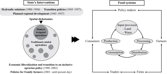
Spatial dichotomies
State’s Interventions Food systems
Policy makers
Farmers Consumers
Traders Firms
Production Processing
Input provision - Land - Water
Economic liberalization and transition to an inclusive agrarian policy (1980–2002)
Policies for Family farmers (2003– until present day) Modern
irrigated agriculture Traditional rainfed
agriculture
Hydraulic solutions (1900–1944) Transition policies (1945–1957) Planned regional development (1945–1957)
Distribution Consumption
Figure 1: Conceptual Framework.
Source: own composition
Conceptual scheme
The conceptual framework contains two parts: the State’s intervention, and the food system’s activities. The first part concerns public policies implemented in the semi-arid region.
The period between 1900 and 1980 was decisive towards creating spaces for modern irrigated agriculture, outlining the dichotomies of the agrarian space. The second part cor- responds to the policies’ influence over the activities of the food systems (input provision, producing, processing, trad- ing, and consuming).
State’s intervention and the production of the agrarian space dichotomies
The Portuguese occupation of the Brazilian territory in the colonial period (16th Century) was characterised by the appropriation of sparse sites, especially in the coastal areas due to the fertile lands. Thus, remote regions, such as the semi-arid, were neglected for years (Andrade, 2004; Prado Jr, 1981). The first interventions of the federal government were launched in the 20th century to mitigate effects of droughts. The policies involved the construction of hydrau- lic infrastructure, such as public and private dams, irrigation canals, reservoirs, well drilling and drainage (Alves, 1982;
Silva, 2006).
Between 1945 and 1957, the federal Government launched policies to promote socioeconomic development by exploring the economic potential of the São Francisco River and granting credit lines to foster the local economy (Duarte, 2002). Transition policies went beyond the pattern of the previous period since in addition to mitigating the effects of drought, the policies aimed at a deeper structural change in economy and society.
In 1958, studies were carried out by the Working Group for the Development of the Northeast (GTDN) aiming at identifying the causes of regional poverty and underdevel- opment and raise possible solutions (Furtado, 1997). The reports concluded that poor management of the resources, unequal access to means of production such as inputs, land, water and capital were the main issues (Furtado, 1997). The study also revealed the aptitude for irrigation of spatial frag- ments, especially the São Francisco river humid Valleys.
Based on the results and also influenced by the productivist paradigm, the federal government started to invest in indus- trial and agricultural projects.
Thereafter, the State devoted itself for creating a space for the development of a modern agriculture, based on irri- gation. For that purpose, three main actions guided public investments (Ortega and Sobel, 2010):
1. Investments in the construction of federal highways to link irrigated areas to urban centres in the country, construction of electrical grids to supply electricity, networking and communication infrastructure, Petro- lina airport and the Sobradinho dam (Sobradinho hydroelectric power plant). These investments were prior to the implementation of the perim-
eters and were fundamental to connect the region to markets.
2. Investments in irrigation comprised the construc- tion of canals, water pumps and irrigation reser- voirs. The São Francisco Valley Development Com- pany (CODEVASF) and the Brazilian Agricultural Research Corporation (EMBRAPA) cooperated in planning and execution of the works and prepara- tion of agricultural studies, respectively.
3. Incentives for private investment, such as financial and fiscal incentives such as the Financial Assistance Programme for Agroindustry and Industry of Inputs, Machines, Tractors (Proterra/Pafai, 1971), and further financing programmes for the capitalisation of agro- industrial companies, such as the Northeast Agroin- dustry Development Programme (PDAN, 1974), the Agroindustrial Development Programme and the National Agroindustry Assistance Programme.
In the 1960s, irrigated agriculture pilot projects started to be implemented in the humid valleys of the São Francisco river situated in the municipalities of Petrolina and Juazeiro.
Between 1980 and 1990 the trend towards neoliberal policies promoted a dismemberment of the public sector, through the privatisation of public institutions. From 1990 onwards the State expanded the process of agrarian reform across the country and launched programmes to include tra- ditional family farming in the regional development project.
The National Programme for Strengthening Family Farming (PRONAF), created in 1996, was one of the first programmes that granted credit to family farmers.
The State’s movement towards policies to Family farm- ers from the 2000 onwards is especially characterised by the expansion and consolidation of more inclusive meas- ures, based on the conception of territorial development, unlike the sectorial previous model of development, which focused on the modernisation of agriculture and irriga- tion. The State launched programmes to promote access to water through cisterns to traditional rainfed farmers (One Million Cisterns for Drinking Water – P1MC , 2003), cre- ated institutional markets and food security programmes (Food Procurement Programme – PAA; 2003 and National School Feeding Programme – PNAE, 2003) and imple- mented programmes to offer rural technical assistance to family farmers (Technical Assistance and Rural Extension programme – ATER, 2010).
Materials and Methods
Case study
Our case study entails sites situated in the municipalities of Petrolina and Casa Nova, which are part of the Brazil- ian semi-arid region. High temperatures and droughts are characteristic of the region, which features annual average rainfall and temperature of 800 mm and 25.4 ºC, respectively (Malvezzi, 2007). The regional aridity relates to spatiotem-
poral rainfall concentration, since 71% of the precipitation occurs between January and April. In addition, the rate of evaporation of 3,000 mm/year is three times higher than the precipitation (Malvezzi, 2007). The region is crossed by the São Francisco River, which is the main source of water for irrigation in the region. The semi-arid space is covered by seasonally dry tropical biome, so-called Caatinga, which presents a great diversity of species resistant to long periods of drought, such as xerophilous and deciduous vegetation (Por et al., 2005).
The semiarid region’s levels of poverty have historically stood out as the highest in the country. Out of the nearly 13.4 million Brazilians (6.5% of the country’s population) currently living in a situation of extreme poverty (monthly household income per capita below R$133,70 – maximum of US$1,90 per day), about 7.3 million are residents of the semiarid region (PNAD, 2016). In Figure 2, the location of the municipalities of Petrolina and Casa Nova can be seen.
The municipality of Casa Nova covers an area of 9.697 km² and is home to 64,940 inhabitants, 42% of whom reside in rural areas (IBGE, 2010). The extension of the territory of Petrolina is 4.561 km² and presents a population of 293,962 inhabitants, 25% of whom are from rural areas (IBGE, 2010). The criteria we used to select both munici- palities were as follows: (1) availability of secondary data from agricultural census survey at the municipal level; (2) the differences and convergences between Petrolina and
Fundo de pasto communities Nilo Coelho irrigated perimeter São Francisco River
Municipalities of Petrolina and Casa Nova Semi-arid region
Melancia Ladeira Grande Riacho
Grande
São Francisco River
Apodi River Piranha acu River
Paraiba River Jaguaribe River
44º0′W 34º0′W
10º0′S 10º0′S
0 250 500 750 km
44º0′W 34º0′W
Figure 2: Location of the case study on two spatial scales: municipal (Petrolina and Cana Nova) and local (rainfed area, fundo de pasto communities and irrigated perimeter of Nilo Coelho).
Source: own composition
Casa Nova in terms of agrarian space; and (3) the prevailing food systems (irrigated agriculture and rainfed agriculture) that are relevant for the regional economy. In Petrolina we visited irrigated agricultural areas, the so-called irrigated perimeter, and in Casa Nova we visited traditional rainfed farming communities.
Data collection
Both primary and secondary data were used in this study.
Primary qualitative data were collected during the fieldwork we conducted in the municipalities of Petrolina and Casa Nova in two occasions: the first in July 2018 and the sec- ond from October 2018 to January 2019. Secondary data were sourced from agricultural census of 2017, published by the Brazilian Institute of Geography and Statistics (IBGE).
Primary data were gathered through participatory observa- tion, focus groups and semi-structured interviews. We also took notes and made audio recordings. In Petrolina we vis- ited irrigated areas and interviewed the representative of a fruit-growing agro-company, three family farmers who grow fruits and annual crops (e.g. onions, beans, cassava, maize) in the irrigated areas and three family farmers that occupy the peripheries of the irrigated areas (agrovilas). In Casa Nova we visited the rainfed areas, where we conducted six focus groups with traditional family farmers from the fundo de pasto communities of Melancia, Riacho Grande and
agriculture and modern irrigated agriculture. Policies were translated into differentiated opportunities for rural develop- ment in the Brazilian semi-arid agrarian space.
Results
The dichotomies of the agrarian space
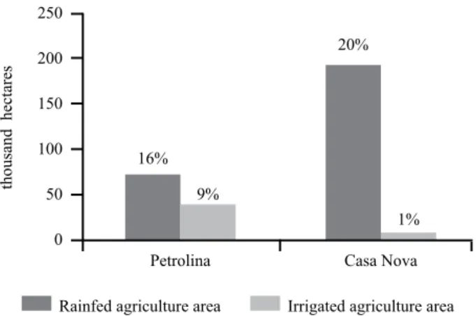
Petrolina and Casa Nova present spaces of both modern irrigated agriculture and traditional rainfed agriculture, but different proportionalities in terms of the food systems’ spa- tial distribution. As can be seen in Figure 3, the area covered by the rainfed food system is more significant in comparison to the irrigated fields in both municipalities. However, look- ing at the detail, we perceive that in Casa Nova the rain- fed area is around double that of Petrolina’s. On the other hand, the irrigated area of Petrolina is about four times larger than Casa Nova’s, measuring approximately 397 km² and 90 km², respectively. Based on this data, we chose to analyse irrigated areas of Petrolina and traditional rainfed areas of Casa Nova.
The space of irrigated agriculture is composed of public irrigation projects, so-called ‘irrigated perimeters’. These projects resulted from the period of planned regional devel- opment (1958–1980). The creation of the perimeters involved two primary actions of the State: (1) the transformation of public lands into private lands and (2) investment in the construction of canals, water pumps, irrigation reservoirs, as well as infrastructure for transportation, energy, communica- tion, etc. We visited the irrigated perimeter of Nilo Coelho, which is located in the municipality of Petrolina and covers an area of 18.667 hectares, being equivalent to 46% of the Petrolina’s irrigated area.
The irrigated perimeters are occupied by agricultural companies (national and multinational) and capitalised family farmers. Fruits of temperate and tropical climate are grown in the lands of agribusiness. In contrast, fruits and annual crops are grown in the lands of family farmers. The labour employed by agribusiness comes from urban areas (people who make the countryside-city commute every day) Lagoa Grande. We also conducted eleven semi-structured
interviews with academics and representatives from NGOs, social movements, and private and public institutions4. Sec- ondary data were obtained through digital platforms of the public institutions mentioned above. We collected data on the following topics: area occupied by the food systems (irri- gated agriculture and rainfed agriculture), number of farmers and companies in the irrigated and rainfed areas, main crops grown, animal rearing and trade.
Data analysis
Primary data were used to support local-scale analy- sis of the agrarian space, which comprises the irrigated areas (irrigated perimeter) and rainfed areas (traditional fundo de pasto communities). Secondary data were collected to support analysis at the municipal scale considering differ- ences and convergences of agrarian spaces of Petrolina and Casa Nova. We analysed the forms of the State’s interven- tion in the different activities of the food systems, which include input provision, producing, processing, trading, and consuming.
According to the federal law (Act No. 11.326, July 24, 2006), family farmers are the rural family entrepreneurs who practice activities in rural areas and, simultaneously, meet the following requirements: (1) do not hold, in any way, proprietary property of a size greater than four fiscal mod- ules5; (2) use, predominantly, the labour force of their own family in the economic activities of their property or enter- prise; (3) the family income must come, predominantly, from economic activities linked to the property or enterprise; (4) manage their property or enterprise with their family. The remaining productive models that do not fit this definition are considered “non-family farming”, according to the Bra- zilian Institute of Geography and Statistics (IBGE). Since the data from the agricultural census uses this criterion to define the types of farmers in Brazil, we also use the same nomenclature.
Hypothesis
The construction of the agrarian space is influenced by the interaction of different actors and elements (civil society, geographic objects, institutions and the State). However, in this study, we approach the State’s contribution as central to the agrarian space (re)production. The study hypothesis consists in the assumption that the historical spatial and sec- toral selectivity of public policies was decisive for building a dichotomous agrarian space, characterised by traditional
4 The institutions that participated in this study break down as follows: Brazilian Agricultural Research Corporation (EMBRAPA), Food and Nutrition Security National Council (CONSEA), Regional Institute for Appropriate Small Farming and Animal Husbandry (IRPAA), Advisory Service for Rural People’s Organizations (SASOP), Pró-Semiárido, Pastoral Land Commission (CPT), Agrarian Development Coordination (CDA) and Secretariat for the Promotion of Racial Equality (Sepromi), São Francisco Valley Development Company (CODEVASF) and Irrigation District of Nilo Coelho.
5 Fiscal module is the unit applied to define the land size (in hectares). The mini- mum lot size must be sufficient to meet the families’ necessity in terms of food pro- duction for their livelihood and for economic purposes. The size of a fiscal module varies according to the municipality where the property is located. In Petrolina a fiscal module covers an area of 55 hectares, while in Casa Nova a fiscal module covers an area of 65 hectares.
Rainfed agriculture area Irrigated agriculture area 250
200 150 100 50 0
thousand hectares
16%
9%
20%
1%
Petrolina Casa Nova
Figure 3: The proportion of food systems’ spatial occupation in Petrolina and Casa Nova (2017).
Source: IBGE, 2017 and EMBRAPA (fieldwork data collection)
and from the rainfed areas. The land occupation of the irri- gated perimeter of Nilo Coelho is shown in Table 1.
At the perimeter of Nilo Coelho, we visited an agribusi- ness plot of 390 hectares (340 hectares for growing man- gos and 50 hectares for grapes) that during the harvest hire approximately 900 workers. We also visited three lots of family farmers, whose area varies from 8 to 14 hectares, one focused exclusively on mangoes and two of which growing mangoes, acerola and annual crops. Permanent employees range from 4 and 6 and in the harvest period, the number of extra persons working on the farm might reach 15 tem- porary workers. In addition, we visited three small lots of family farmers that occupy the peripheries of the perim- eter, so-called agrovilas, each lot-sizing approximately 2 hectares, which are used for growing mangoes and organic annual crops. The irrigated perimeter is managed by the Irri- gation District, which is a non-profit legal entity responsi- ble for maintaining the hydraulic infrastructure, controlling water use and collecting fees.
The traditional rainfed food system occupies public lands and farmers are dependent on rainwater for self- consumption and food production. We visited three traditional communities in the municipality of Casa Nova that occupies an area of 15,100 hectares, which corresponds to approxi-
mately 8% of the rainfed area of the municipality. The rainfed area is occupied by family farmers from traditional commu- nities (quilombolas, povos de terreiro, fundo de pasto, arti- sanal fishermen, etc.) and family farmers settled on agrarian reform settlements. They produce crops such as fruits, veg- etables, greenery and practice extensive livestock production with such animals as cattle, chicken, pig, but mainly goats.
The traditional rainfed farmers we visited in Casa Nova are so-called fundo de pasto communities, whose main feature is the communal land (used for animal rearing) combined with individual areas (used for family crop production).
Table 2 shows the key characteristics of each community.
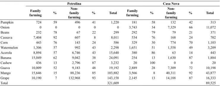
Table 3 shows the main crops grown in both municipali- ties, according to the type of producer (family farmers and non-family farmers). Petrolina produces more fruits, while Casa Nova stands out more for the cultivation of vegetables and grains, such as onions, beans and corn. When compari- sons involve the type of producers, it is noticeable that non- family farmers produce considerably more grapes and man- goes while family farmers are engaged in producing fruits, vegetables and grains in a more balanced way.
The goat production, as shown in Figure 4, is more prom- inent among family farmers of Casa Nova. Goats are the main source of income of the fundo de pasto communities
Table 1: Land occupation of the irrigated perimeter of Nilo Coelho.
Family farmers Agribusiness
Number of lots 1,983 244
Area in hectares 12,027 6,024
Source: Fieldwork data collection
Table 2: Main features of the fundo de pasto communities participating in this study.
Community Total number of
families Size of land occupied (hectares)
Melancia 42 600
Riacho Grande 211 12,000
Ladeira Grande 60 2,500
Source: Fieldwork data collection
Table 3: Quantity produced by family and non-family agriculture according to the municipality (tons).
Petrolina Casa Nova
Family
farming % Non-
family
farming % Total Family
farming % Non-
family
farming % Total
Pumpkin 724 59 496 41 1,220 181 58 132 42 313
Onion 0 0 0 0 0 3,743 34 7,329 66 11,072
Beans 232 78 67 22 299 292 79 79 21 371
Cassava 7,404 92 607 8 8,011 534 76 168 24 702
Corn 443 76 143 24 586 329 30 774 70 1,103
Watermelon 1,306 57 992 43 2,298 1,651 51 1,558 49 3,209
Acerola 8,894 57 6,746 43 15,640 380 86 63 14 443
Banana 15,049 62 9,042 38 24,091 254 13 1,630 87 1,884
Cashew 436 13 2,796 87 3,232 20 100 0 0 20
Guava 10,009 52 9,183 48 19,192 2,889 28 7,309 72 10,198
Mango 15,646 15 88,236 85 103,882 3,566 8 40,311 92 43,877
Grape 10,190 7 132,968 93 143,158 2,145 13 14,188 87 16,333
Total 321,609 89,525
Source: IBGE, 2017
250 200 150 100 50 number of goats (thousand) 0
Petrolina Family
farming Non-family farming
Casa Nova Family
farming Non-family farming
Figure 4: The goats rearing (number of goats) by region and area.
Source: IBGE, 2017
and are raised extensively, feeding on native vegetation and consuming water from dams. Also, in Petrolina, family farm- ers produce more goats than non-family farmers.
In face of the above results, we interpreted that in Petro- lina, where the irrigated areas are larger than the Casa Nova’s, non-family farming stands out for fruit production, whilst in Casa Nova, where the rainfed area is considerably superior, the amount of vegetables, grains and goats is greater. In both municipalities, family farming produces more vegetables, grains and goats than non-family farmers.
The State’s influence over the activities of the food systems
Input provision: land access
In the case of Nilo Coelho perimeter, there are disagree- ments concerning the land’s occupation before its trans- formation into irrigated perimeters. While the irrigation district employee affirmed that the lands used for the activi- ties were vacant, the representatives from Pró-Semiárido and the Pastoral Land Commission (CPT) stated that the lands were occupied by landless squatters and family farm- ers that had no land title. As a consequence of the irriga- tion policy, squatters and family farmers were expropriated and communal public land were transformed into private properties.
The access to the lands of the irrigated perimeters is made through land purchases. In the first years of the occupation, land payment could be made within 10 years, with low inter- est rates and tax incentives. The historical occupation of the perimeter may be divided into two main periods, according to the member from the irrigation district. At first, in the 1970s, the land was occupied by traditional farmers and small family farmers from nearby areas who had experience with small- scale irrigation practices. In the second phase, mid-1980s, the federal government moved away from the administration of the perimeters, under the influence of the neoliberalism and also because of the deep economic crisis that hit public accounts. The crisis affected the farmers in the perimeters, who sold their land and moved to the rainfed area nearby the perim- eters (agrovilas). Subsequently, the traditional farmers were replaced with small agricultural entrepreneurs and national and international companies (agribusiness). According to the irrigation district employee, it was when the fruit growth and trade expanded to national and international scales. Currently, only 10% of the first farmers continue occupying the land of the Nilo Coelho perimeter, which means that family members are no longer the natural successor.
The three farmers who live in the agrovila explained how they failed to subvert the logic of capitalist accumulation and sold their land. Below we highlight an excerpt from the tes- timony of one of the farmers.
“I know a lot of people who left the business, went back to work as employee. They lost everything. At least I live here in Agrovila and I have my land. It’s small, but I can live.
Better than in the city. I was unable to complete the pay-
ment for the land because the profits went down. I had to sell it. I sold it to a businessman from São Paulo. The problem of selling to these people is that they do not diversify [the production]. They prefer monoculture … then people in the region lack food.”
The traditional communities of farmers occupy rainfed land for over two hundred years and many do not have the land title, according to the Regional Institute for Appropriate Small Farming and Animal Husbandry (IRPAA).
In 2013 the State of Bahia launched a plan (Law 12.910), which provides for a contract regarding the right of land usu- fruct for up to 90 years, with the possibility of renewal for an equal period. Participants from the fundo de pasto communi- ties reported that they have rights to this land and, for this reason, they claim that they deserve land titles, not simply an authorisation to occupy the land for a certain period. They also stated that accepting the contract meant confirming the premise that the land does not belong to them, as dictated by the State government.
As reported in focus groups the communities’ land strug- gles began in the 1970s when the federal government built the Sobradinho hydroelectric dam, flooding an area of 4,214 km² and displacing approximately 12,000 families, includ- ing some of the study participants. The dam construction set a precedent for land grabbing in the region. Land grabbing is an old practice in Brazil, typically beginning with irregu- lar occupation of land, supported by fraud and falsification of property titles. In 1979, there was an intense and violent conflict between the communities and a company that ille- gally occupied their lands for cattle production. Families were displaced, farmers were threatened with death, and a community leader was murdered. Nowadays, communities fear losing their lands to wind power companies, agribusi- nesses, and mining companies, which have been advanc- ing in the region with the collusion of the government of Bahia6.
Input provision: water access
The irrigated perimeter of Nilo Coelho was created by the federal government between 1984 and 1996. The public investments entailed the construction of irrigation infrastruc- ture (canals, water pumps, irrigation reservoirs) and electri- cal station to pump water from the São Francisco River. The Irrigation District manages the system and charges farmers and companies for water use. Families settled in the agrovi- las collect water irregularly from the canals to grow crops such as organic fruits and vegetables. Given their illegal status, they do not pay the fee for water consumption. This situation is, constantly, the cause of conflict between insiders and outsiders. The Irrigation District takes strict measures, interrupting clandestine access to water.
Despite being close to the São Francisco river (see Figure 1), irrigation sourced from the river is not possible to the fundo de pasto communities. Rainwater is the main
6 The government of Bahia implemented a series of measures to attract investments, including offering concessions of State land for industrial and agricultural use and energy production; offering reductions and exemptions from State taxes, and offer- ing low-interest financing (FIEB, 2019; SEI, 2019).
source of water for drinking and producing. The water is col- lected through the gutter installed on the roof of the houses and drained to the cisterns, where it is stored. Cisterns are given to the families through the federal programme One Million Cisterns for Drinking Water (P1MC). The P1MC became public policy in 2003 and participants confirmed they had at least one cistern.
Among the benefits of the cisterns, focus group par- ticipants highlighted its role in freeing women from daily long walks for water collection, since they were in charge of ensuring household water security. The testimony bel- low we got from a female farmer from the fundo de pasto community.
“Now that we have the cisterns, the pain in my back reduced because I used to carry water since I was seven years old. We used to walk about 15 km a day or more. Now that we have cisterns at home, we can store water. In the past, the water truck brought water, but since we had no cistern, the water was thrown to the ground. Sometimes having a place to store is so much more important than having access to water itself.”
In the same focus group, we also discussed the role of the cisterns in food production. We selected the following testimony to illustrate the perception of a rainfed farmer on the subject.
“They [cisterns] were important because now we have water for small irrigation. At home, we began to produce more fruits and vegetables, for example. We also consume more of the food grown on our farm.”
The cisterns’ efficiency depends on the availability of rainfall throughout the year. As reported by the partici- pants in focus groups, due to recurrent droughts the water in the cistern runs out in certain periods of the year, forc- ing families to rely on government assistance for water supplies. To improve people’s autonomy regarding water access, one academic interviewed recommended imple- mentation of structuring measures to mitigate the effects of the drought, including the construction of small water aqueduct systems to connect the communities to the São Francisco River.
As mentioned above, another way to access water is through the water truck provided by the federal government, which is an emergency supply. The municipal government is responsible for planning water distribution and the army is in charge of hiring water suppliers and controlling the water supplied per house. However, according to participants in the focus groups, there is a mismatch between the plan and the execution of the project. In general, the water provision is inefficient because the amount does not meet the real needs of the communities. Below we selected a statement taken from the focus group dialogues.
“A clear example of disconnected measures is that last year the municipality of Casa Nova was provided with 10 water trucks, when actually its rural population demands water consumption of at least 90 trucks.”
Producing and processing
The State has been involved in helping production and processing activities in irrigated areas by providing techno- logical and scientific knowledge through the Brazilian Agri- cultural Research Corporation (EMBRAPA). EMBRAPA’s office in semi-arid was created in 1975 to develop scientific studies in the field of agronomy to support the agriculture in irrigated areas. Below we highlight the testimony of an employee from EMBRAPA semi-arid on the importance of the institution for the development of the initial phase of fruit growing in irrigated areas.
“Embrapa was crucial in transforming the perimeter of Nilo Coelho into a station dedicated exclusively to the culti- vation of fruits. This occurred around the end of the 1980s.
EMBRAPA tested different fruit species, such as mangoes and grapes, so that the region would become attractive to private capital. We knew already that mangoes and grapes were well accepted in the global market.”
Embrapa’s representative informed us that the genetic modification of the seeds allowed the cultivation fruits of temperate climate in edaphoclimatic conditions of the semi- arid region, which has high temperatures, high insolation and low humidity throughout the year. Besides, it helped to improve productivity and resistance to pests, to meet mar- ket demands (e.g. seedless grapes, mangoes with little fibre, fruits with uniform colours and appropriate balance between sugars and acids) and to extend the post-harvest conservation capability.
As a result of the adaptations, currently, grapes are pro- duced twice a year and the length of the mangoes’ growth cycle has been reduced to 10 months. With no influence of genetic engineering services, this period would be nine months for grapes and 12 months for mangoes. In addition, producers manage the harvest in order to make it coincide with the off-season periods of other producers located in Bra- zil and abroad, benefiting from their competitive advantage.
EMBRAPA also offers assistance to producers to get their products certificated, meeting the requirements imposed by the world market. Table 4 illustrates the mangoes and grapes growth cycle.
The State also offers technical assistance for farmers in rainfed areas, but the assistance was institutionalised in 2010, through the creation of the Technical Assistance and Rural Extension programme (ATER). The main goal of ATER is to transfer technical knowledge to family-farm food systems via environmental education, introduction of endogenous production techniques, and transition to agroecology (Brasil, 2018). In Bahia, policymakers opted for outsourcing this ser- vice to NGOs and other private entities, which are contracted through public calls.
Table 4: Mangoes end grapes growth cycle.
Crops Jan Feb Mar Apr May Jun Jul Aug Sep Oct Nov Dec
Mangoes 1 cycle
Grapes 1 cycle 1 cycle
Source: Fieldwork data collection
According to farmers, environmental education includes discussions of sustainable solutions to cope with the semi- arid climate. Regarding food security, the NGOs help farmers and associations make applications in response to public calls to participate in the PNAE (National School Feeding Programme) and PAA (Food Procurement Pro- gramme). This assistance has been fundamental, because farmers affirmed that they were not used to dealing with bureaucracies and formal contracts. Concerning agricul- tural practices, the projects involve assistance with soil management, creation of a seed bank, and preservation of the region’s characteristic biome (Caatinga). The NGOs also encourage the transition to agroecology through the use of organic matter (manure) as a natural fertiliser (thus avoiding use of chemical fertilisers). Participants reported that the technical assistance enabled them to understand the benefits of agroecological practices that they applied intui- tively, providing insights into how they work to maintain a resilient environment.
One of the problems identified by the communities was that by outsourcing the technical assistance service, the num- ber of family farmers receiving support had fallen. Partici- pants stated that when the Bahia State government provided the service in the past, it covered more families. They said that the institutions that replaced the State in this function have a limited budget, which translates into less coverage.
Participants pointed out that since some families were not informed and properly guided regarding the procedures and bureaucratic steps involved in applying for contracts, they had difficulties accessing public policies.
Trading and consuming (food security)
The producers from the irrigated perimeter have easy access to the market, as they are close to the urban centre of Petrolina. In other words, producers have access to trans-
port infrastructure, such as airport and federal roads (see Figure 1). The State’s investments in transport, communica- tion and energy infrastructures turned the irrigated territory more fluid to exchange goods and movement of people. Dif- ferently, famers in rainfed areas – especially the communi- ties we visited – are distant from urban markets and devoid of adequate transportation infrastructure. Figure 5 shows the infrastructure implemented in the region.
In Figures 6 and 7, we see the main commercialisation niches for food produced in the municipalities of Petrolina and Casa Nova. The data from the agricultural census did not cover the differentiation between family farming and non- family farming for this indicator.
The most important common aspect shared by the munic- ipalities is the sales to middlemen/ intermediaries. Many middlemen are farmers or micro-entrepreneurs from nearby localities that purchase a variety of products from producers at a lower price and resell to large supermarket chains and export. The intermediaries are strong because, according to farmers from both areas, for many years they were one of the only forms of trade. Farmers and intermediaries created strong bonds over time and built relationships based on of trust and friendship. Therefore, despite the advent of food procurement and other trade mechanisms, intermediaries are still very important for the production flow.
In Casa Nova, sales of food through cooperatives and associations involve products such as corn, cassava, beans and onions. Data on the destination of the goats were not available through census data, but according participants most part of the animals are sold through cooperatives.
According to farmers, sales through cooperatives and asso- ciations usually occur within the standards of the mediated market, through the Food Procurement Programme (PAA) and National School Feeding Programme (PNAE). In both municipalities, products are pooled together for collective sales, enabling economies of scale.
Casa Nova
Petrolina
9º0′S
42º0′W 41º0′W
42º0′W 41º0′W
Local communities Nilo Coelho irrigated area São Francisco River
Municipalities of Petrolina and Casa Nova
Airport of Petrolina Federal roads Railway Semi-arid region
Hydroelectric power plant Electricity grid
0 25 50 75 km
N
Figure 5: Geographical distribution of physical infrastructure in the agrarian space.
Source: own composition
Exports are also expressive in both municipalities, espe- cially mangoes and grapes, which are fruits mainly produced in irrigated areas. Petrolina exports 70 thousand tons of grapes and 29 thousand tons of mangoes, respectively, which corresponds to approximately three times more than Casa Nova exportation. In terms of absolute values, Petrolina exports more, but in figures 3 and 4 we see that Casa Nova exports most of mangoes and grapes produced in its territory.
Also, annual crops (pumpkin, beans, cassava and maize) are sold directly to consumers, which means that these products are mostly sold at local fairs, in addition to being highly con- sumed by families, especially those from the municipality of Casa Nova.
As for access to food in satisfactory quality and quantity, as food security advocates (FAO, 1999), rainfed areas stand out for subsistence agriculture, with a low level of food inse- curity. Figures 5 and 6 show that a large amount of the food produced is consumed. However, farmers admitted that vul- nerability to food insecurity is more imminent in periods of drought, pointing out that the semi-arid climate aggravates food insecurity, but the problem is rooted in low household income and high levels of poverty. The drought that occurred between 2005 and 2009 was remembered as a difficult time for food production and in this period families in the com- munities received cassava, milk, rice and beans from PAA.
They also highlighted the importance of food procurement programmes (PAA and PNAE) as an important means for achieving income stability, translating into household finan- cial planning concerning family feeding.
In the irrigated areas, there is also no evidence of food insecurity, given that farmers in these lands are financially able to purchase food. However, if food supply is considered on a regional scale, productive specialisation is a negative indicator, as it means that family farming is using land to produce food to satisfy market demands and not to satisfy the population’s demands for food that meet their dietary needs.
Discussion and Conclusion
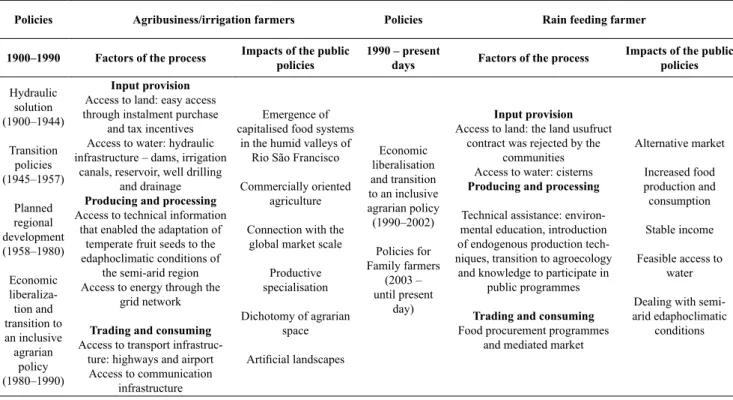
Public policies transformed the agrarian space of the semi-arid region for generating productive restructuring of activities and spatial dichotomies. The territorialisation of the capitalised food systems was based on a set of policies launched between 1900 and 1990 that involved the construc- tion of hydraulic infrastructure for irrigation, arrangements for communication and energy supply, easy access to land and technical information. The consequences of these com- mercially oriented policies include the dichotomies of agrar- ian space, the emergence of capitalised food systems in the humid valleys of the Rio São Francisco, the imposition of productive specialisation and connections with the global market scale.
Policies for traditional family farmers lasted almost a cen- tury after being implemented in the 1990s. Despite the delay, they improved the activities of the farmers from rainfed food system, as we have analysed. The cisterns provided house- hold access to good quality water. Previously, people col- lected unsuitable water from dams located far from the com- munities. Technical assistance helps in the development of a contextualised agriculture, considering edaphoclimatic con- ditions of the semi-arid region. The projects also preserve the caatinga biome and guarantee food security conditions for family farming. Finally, food procurement programmes enabled an alternative market for family farmers. The issue not yet resolved concerns the regulation of communal land, since the communities fight for the title of the land and reject the contract that authorises the use of the land for a limited time. Among the most significant impacts it is worth high- lighting the empowerment of family farmers, access to the institutional market, income stabilisation, and improvements in food production and consumption (food security), as well as the promotion of contextualised practices to deal with semi-arid edaphoclimatic conditions. Table 5 demonstrates
Petrolina
0% 50% 100%
Sales trought cooperative Sales to middlemen Exported
Stored Family consumptionSales to consumers Sales to agro-industries Grape
Mango Guava Cashew Banana Acerola Corn Watermelon Cassava Beans Onion Pumpkin
Figure 6: Destination of the products, Petrolina
Source: IBGE (2017)
0% 50% 100%
Casa Nova Grape
Mango Guava Cashew Banana Acerola Corn Watermelon Cassava Beans Onion Pumpkin
Sales trought cooperative Sales to middlemen Exported
Stored Family consumptionSales to consumers Sales to agro-industries
Figure 7: Destination of the products, Casa Nova
Source: IBGE (2017)
the connections between public policies, process factors and policies’ impacts.
The most relevant differences between the set of poli- cies of the two periods are (1) the focus on the modernisa- tion of agriculture versus a more integrative emphasis; (2) commercially oriented goals versus an alternative market for family farmers; (3) the imposition of an artificial landscape to deal with the edaphoclimatic peculiarities of the semi-arid region versus endogenous development. The policies imple- mented between 1900 and 1990 had a biased sectoral char- acter, channelling public investment to food systems mod- ernisation and prioritising the activities of agribusiness and capitalised family farming. In contrast, the policies that have been launched since 1990 are inclusive and aim to develop productive activities for family farmers. These policies have achieved greater coverage since they were targeted at the social group of family farmers, being a counterpoint to pre- vious policies that aimed at developing specific productive activities in selected space fragments.
In this sense, the second characteristic of the policies is the contrasts between the commercially oriented policies and the programmes targeted at family farmers. The first policies comprised investments to make the space more conducive to trade, and through the role of the capitalised food system sought adaptations of productive practices and food in order to serve the national and international market. In contrast, the second group of policies were targeted at family farmers’
activities, aiming at the stabilisation and resilience of their food system through the creation of alternative markets.
Finally, the first group of policies transformed the land- scape to promote capital accumulation through investments in irrigation. Currently, tropical and temperate climate crops share space with original drought-resistant species,
Table 5: Links between public policies, process factors and policies’ impacts.
Policies Agribusiness/irrigation farmers Policies Rain feeding farmer
1900–1990 Factors of the process Impacts of the public
policies 1990 – present
days Factors of the process Impacts of the public policies Hydraulic
solution (1900–1944)
Transition policies (1945–1957)
Planned regional development (1958–1980)
Economic liberaliza-
tion and transition to an inclusive agrarian
policy (1980–1990)
Input provision Access to land: easy access through instalment purchase
and tax incentives Access to water: hydraulic infrastructure – dams, irrigation
canals, reservoir, well drilling and drainage Producing and processing Access to technical information
that enabled the adaptation of temperate fruit seeds to the edaphoclimatic conditions of
the semi-arid region Access to energy through the
grid network Trading and consuming Access to transport infrastruc-
ture: highways and airport Access to communication
infrastructure
Emergence of capitalised food systems
in the humid valleys of Rio São Francisco Commercially oriented
agriculture Connection with the
global market scale Productive specialisation Dichotomy of agrarian
space Artificial landscapes
Economic liberalisation and transition to an inclusive agrarian policy (1990–2002)
Policies for Family farmers
(2003 – until present
day)
Input provision Access to land: the land usufruct
contract was rejected by the communities Access to water: cisterns Producing and processing Technical assistance: environ- mental education, introduction of endogenous production tech- niques, transition to agroecology
and knowledge to participate in public programmes Trading and consuming Food procurement programmes
and mediated market
Alternative market Increased food production and consumption Stable income Feasible access to
water Dealing with semi- arid edaphoclimatic
conditions
Source: own composition
such as cacti, the original species of the caatinga biome. In contrast, the new policies strategically respect and preserve the edaphoclimatic conditions of the semi-arid climate (e.g.
cisterns provide household water consumption, without the need to transform the landscape).
The great contradiction is that the first group of policies strengthened modern irrigated agriculture in a way that they became self-sufficient and their activities were consolidated.
During this period small-scale producers were marginalised and did not benefit from policies. In contrast, recent policies have strengthened family farmers by stabilising their food system activities and safeguarding farmers’ livelihoods.
However, despite these improvements, the disparities in power between the actors from irrigated and rainfed areas remain very large.
Federal policies targeted at family farmers clearly did not equalise the differences between food systems in the region.
Family farmers face disadvantages, since they lack the capi- tal and transport infrastructure – being far from the markets they need to access – and furthermore, they have limited access to water, and legally no access to land. All of these elements together translate into powerlessness.
Achieving a more equal environment means strengthen- ing the voice and participation of small-scale producers in policymaking, while reducing the power of agribusiness.
Policies must support producer organisations, increase the participation of family farmers in the policy making process, devise a competition policy that protects these small pro- ducers, and impose high export taxes. Also, to improve the living conditions of fundo de pasto communities, the public agenda must include expanding access to rural infrastructure and services, such as roads, public slaughterhouses, physical markets, telecommunications, and electricity.