GEOMORPHOLOGY AND THE
CHANGING ENVIRONMENT
IN EUROPE
GEOMORPHOLOGY AND THE CHANGING ENVIRONMENT IN EUROPE
EUROPEAN REGIONAL CONFERENCE organised by the
INTERNATIONAL ASSOCIATION OF GEOMORPHOLOGISTS (IAG)
Hungarian Academy of Sciences Budapest, 9 April, 1996
P lenary papers
edited by Denes L 6c z y
Bu d a p e s t
1996
Technical Board:
Laszlo Ba s s a
Denes L 6c z y
Pal Mu l l e r
Published and copyright by the Geographical Research Institute Hungarian Academy of Sciences Budapest
ISBN 963 7395 72 5
Evolution of Surfaces of Planation
Controlled by Tectonic and Erosion/Accumulation Cycles:
A Model for the Geomorphologica! Evolution of the Transdanubian Mountains, Western Hungary
P£csi, Marton
Geographical Research Institute, Hungarian Academy of Sciences P.O.B. 64 H-1388 Budapest, Hungary
A bstract
This model claims that the surfaces of planation once produced by some erosional processes, were reshaped in the later geological periods by repeated, alternating erosional and accumulation processes on the morphostructure also repeatedly affected by tectonic uplift, subsidence and horizontal displacement.
According to this model, late Mesozoic tropical etchplanation with paleokarst and bauxite formation did not continue during the Tertiary in the Transdanubian Mountains o f Hungary. As a consequence of multiple differential tectonic subsidence, most of the range was buried in various thickness and at various intervals. This burial was followed by complete or partial exhumation on at least three occasions (Paleogene, Neogene and Quaternary). During repeated burial and exhumation the Cretaceous tropical etchplain was affected by further erosion or accumulation through non-tropical processes (such as peripedimentation, marine terrace formation, alluvial fan building and others). In the horst series of the Transdanubian Mountains, divided by graben-like basins, the position and evolution of the geom orphological surfaces allows the identification of some main groups:
1. (semi)exhum ed horst of etchplanation in summit position;
2. buried horst of etchplanation in uplifted position;
3. horst o f etchplanation in threshold position, buried or exhumed and reshaped, mostly pedimented;
4. buried etchplain in basin position;
5. peripediments, rock pediments, locally buried under detritus.
The model o f geom orphic surface evolution through alternating erosion/accumulation does not only apply to the Hungarian medium-height mountains, but also to
numerous other geomorphological regions, eg. the Alpine-Carpathian-Dinaric Mountains, several old mountains and massifs of Europe and other continents.
Introduction
The term geom orphological surfaces denotes plains and gently sloping slopes, which are the products of erosion, of accumulation or of their combination, under the influence of tectonic processes. Their formation may be dated from their correlative sediments or by other methods.
For the timing of successive formation of landforms, ie. for a reconstruction o f the denudational chronology, an interpretation of the different geomorphological surfaces is needed. Several models were proposed for the development of erosional surfaces (landforms) on great continental morphostructures. Some of these have become classic (DAVIS, W. M. 1906, 1922; PENCK, W. 1924; KING, L. C. 1949, 1962;
BUDEL, J. 1957 and his followers, BULLA, B. 1958; BREMER, H. 1986).
1. According to DAVIS, the peneplain (ultimate peneplain) is the final product of fluvial erosion on different humid regions. The alm ost plane surface is the penultimate phase of the planation at the base level.
2. PENCK's Prim arrum pf (prim ary peneplain) is a plain surface just emerged above the sea level.
Piedmonttreppen (piedmont benchlands) are explained by fluvial erosion and retreat of valley sides.
Erosional surfaces on slowly but uniformly elevating m orphostructures may be explained this way.
3. According to KING, pediplanation also takes place by the retreat o f slopes on slowly but continuously elevating terrains, especially under semiarid climates, where the rate o f the mechanical weathering exceeds that of the chem ical one. Retreat o f slopes results in a gradual surface lowering and pediplain formation. According to KING, pediplanation is the most widespread process reducing relief, this way it replaces DAVIS' peneplain theory.
4. BUDEL proposes that the double etchplain (doppelte Einebnungsflache) is an erosion surface created by intensive lateritic deep w eathering and strong w ashdown (stripping) o f the thick weathered rock under a seasonal dry and w et tropical climate.
5. A pedim ent is a gentle erosional foothill slope in front o f a steep mountain slope, generally formed of hard rock. Pedimentation is admitted to be the most general erosional, planation process. McGEE, W.
J. (1897) believes that a river, on leaving a mountain, deposits most of its load, while the rest of the sediment transported causes lateral planation (corrasion). The pediment is covered by a thin layer of sediment, deposited by sheetwash or by small rivers under a semiarid climate.
Several researchers adhere to the above models for the origin o f surfaces o f planation, while others criticise or modify them. In one respect these models are
uniform, they suppose that the studied surfaces were formed during long geological times, when uplift was slow, continuous or periodical. It is generally admitted that the highest situated geom orphological surfaces are the oldest, the lower ones are ever younger. Such presumptions might only be valid for a part of the cases and for some geological times.
Presumably the planation surfaces (models 1 to 5), explained by different processes, might be attributed to effects of as many different geographical environments. If this
is true, each of these models and conceptions generally represent genetically and climatologically different morphofacies rather than one single, global type of surface.
It must be mentioned that these early models of planation surfaces were based on fixist tectonism .
In this presentation we want to introduce a polygenetic m odel o f geom orphological surface evolution, through processes acting on different morphostructures affected by plate tectonic events, particularly in orogenic belts. The units studied were horizontally displaced over great distances, tectonically dismembered, recurrently uplifted and subsided, thus the planation surface became repeatedly buried, elevated and exhumed again (PEiCSI, M. 1970a,b).
Polygenetic m orphostructures with planation surfaces, which were shaped under the influence of alternating erosional and depositional processes of long duration, were removed from their original place and carried over long distances, passing under various climatic belts. This way units of most different genesis might have come in each other's proximity.
The tectonic and geomorphic history of the Transdanubian Mountains (western Hungary) was used as a model for the evolution of such polygenetic planation geomorphological surfaces. Geological and geomorphological studies of the last half century served as a basis of a new geomorphological evolutionary model, differing from the previously mentioned ones (PEzCSI, M. 1968, 1975, 1993; SZEzKELY, A.
1972).
Discussion
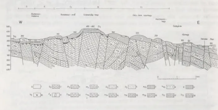
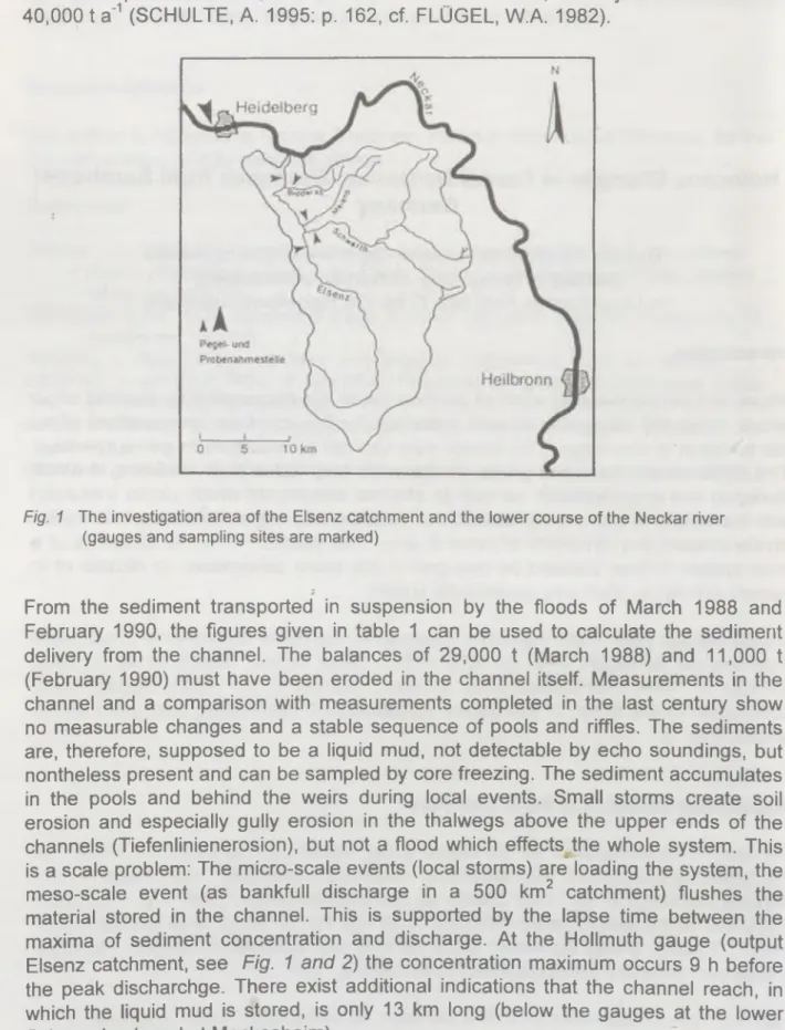
The Transdanubian Mountains (TM) is a low range of slightly folded structure, built mainly of Mesozoic and Paleogene carbonates (limestone and dolomite), affected by overthrusts and faults. Horst and graben structures are common, delimited by mainly NE-SW and NW-SE running structural lines. In the southern foreland a thick Paleozoic sequence of south Alpine affinities underlies the similarly thick Mesozoic strata (Fig. 1).
Comparative structural investigations proved that the TM was a part of the carbonate platform formed at the northern margin of the African plate in the southern Tethys, during the Triassic. During the rifting and subsequent convergence of the Tethys this unit was overthrusted on an oceanic crust fragment, the Penninic unit. The TM, as a part of a microcontinent, was subsequently carried into the southern Alpine area, wherefrom, in late Cretaceous/Paleogene times it was horizontally shifted into the Carpathian basin (HORVATH, F. 1974; G ^CZY, B. 1974; WEIN, GY. 1977, 1978;
BALLA, Z. 1988, HAMOR, G. 1989; FULOP, J. 1989; STEGENA, L. and HORVATH, F. 1978).
During the late Triassic and early Jurassic the low and extended carbonate platform of the TM was cut into a horst and graben structure. In the grabens the sedimentation went on during the Jurassic and early Cretaceous. On the elevated parts a long lasting continental downwearing went on during the Jurassic and Cretaceous. The upper Triassic carbonates were affected by tropical karstification, accompanied by bauxite formation. Cockpits and tower karst may have been formed under tropical savanna climate with humid and dry seasons, simultaneously with bauxite formation. The initial sediments of the bauxite formation were resedimented from siliciclastic areas by sheet wash and by small rivers. Lateritification was simultaneous with karstic planation. Witnesses of this m arked tropical karst planation were buried and preserved by lower Cretaceous (Albian), upper Cretaceous, and, locally, Paleogene sediments in the TM.
Fig. 1 Profile across the Bakony Mountains (after WEIN, Gy. and P£CSI, M.)
1 = Holocene-Pleistocene flu via lsa n d and gravel, alluvial plain; 2 = Upper Pannonian sand and clay; 3 = Lower Pannonian (Miocene) claymarls; 4 = Lower Miocene-Upper Oligocene gravel and sand (in the Dudar Basin); 5 = Eocene coal seams and carbonate rocks; 6 = Lower C retaceous (Aptian, Albian and Cenomanian) limestones and calcareous marls; 7 =
bauxite and related formations; 8 = Jurassic limestones; 9 = Upper Triassic dolomites and limestones; 10 = Middle Triassic limestone; 11 = Lower Triassic siltsstone, marl and
limestone; 12 = Permian sandstones and conglomerates; 13 = Upper Carboniferous granite porphyry; 14 = Lower Carboniferous conglomerate and shale; 15 = Silurian - Devonian phyllite and marble; t = uplifted rem nant of tropical etchplain; ft = buried etchplain; e = exhum ed etchplain, locally covered with Miocene gravel; pe = mountain margin benchland;
h2= Pannonian marine terrace; h, = piedmont surface (pediment); g = Pleistocene piedmont surface form ed on moderately consolidated sediments (glacis); k = remodelled tropical etchplain in threshold position; T6t-2 = prospect drilling; S-D = Silurian-Devonian; T . Tj.Tj,=
Lower, Middle, Upper Triassic; M= Miocene; PI, = Lower Pannonian (Upper Miocene); Pl2 = Upper Pannonian (Upper Miocene);
Buried surfaces of karstic planation may be found between horsts, forelands and on horsts, buried with Cretaceous or Tertiary strata (Figs. 2 and 3).
The tropical karst planation surface of the TM was slightly rem odelled between the late Cretaceous and middle Eocene ( Laramian tectonic phase?). On horsts summits
it was well preserved, but on the margins pediments were formed due to early Eocene subarid coarse clast production. Dolomite karst towers and bauxites, if not buried, were eroded or resedimented.
During middle and late Eocene the area of the TM became an archipelago. Most of its territory subsided continuously, but not uniformly. The sea inundated the low horsts and intramontane basins. Bauxite bearing karstic surfaces of etchplanation were often buried during the Eocene.
Bauxite lenses in sinkholes, capped with Eocene layers, are often interpreted as a result of a continuation of tower-karst plain formation and bauxite genesis in the first part of the Eocene (BARDOSSY, Gy. 1977; MINDSZENTY, A. et al. 1984). This would mean that such bauxites are not merely products of Eocene redeposition of earlier deposits. W e think, however, that early Eocene conditions characterised by dolomite breccia formation were not favourable for bauxite genesis and tower karst
WNW ESE
Fig. 2 Geom orphological surfaces in the V6rtes Mountains in Hungary
A = exhumed horst in sum m it position, a remnant of slightly remodelled Cretaceous etchplain; C = horst in foothill position; C, = totally buried; C3 = totally exhumed; D= buried surface o f etchplain in interm ontane graben position; D-| = intermontane graben, filled with molasse and alluvial fans; E = glacis d’erosion with terraces; E-| = rock pediment and glacis d'erosion; F = rem nants of marine terrace (Upper Pannonian); G = submontane basin with river and glacis terraces; t,-t4= fluvial terraces; mt, = marine terrace; 1 = alluvium and meadow soil; 2 = alluvial fan; 3 = loess and loess-like sediments; 4 = Pannonian sandy and silty formations; 5 = Sarm atian formations; 6 = Miocene gravel and sand; 7 = Oligocene sand and clay formations; 7a = Oligocene lignite; 8 = Eocene limestone; 9 = Cretaceous bauxite;
10 = Triassic dolom ite and limestone; 11 granite; 12= Carboniferous metamorphic rocks
evolution. Under a subaridic climate predominantly coarse clastics were formed and transported by ephem eral water-courses and pedimentation prevailed (PEzCSI, M.
1965, 1970b).
From the Eocene-Oligocene boundary the TM was uplifted and the previously submerged and buried parts were eroded. Some segments or entire horsts were exhumed and subsequently pedimented. There are several horsts, where bauxite and tropical tower-karstic surfaces were preserved under a thick Eocene limestone cover (Fig. 3).
During the second part of the Oligocene the horizontal shift of the TM was going on, its subsidence was highly differentiated. This is supported by the fact that sediments of differing facies (coarse clasts, gravel, sand and clay) were deposited on the surface of the TM, which moved eastward. The sediments originating from some higher, crystalline mountains in the vicinity.
Fig. 3 Alternating erosional/accumulational planation surfaces of the Buda Highland in Hungary (after P£CSI, M. and W EIN, Gy.
A = exhumed, planated surface in uplifted position; B = buried C retaceous etchplain in uplifted position; C = surfaces of planation in uplifted position: 1) totally buried, 2) partially exhumed, 3) totally exhumed; D = buried surfaces o f planation in graben position; E = glacis d'erosion; 1 = Pleistocene loess and wind blown sand; 2 = Pleistocene travertine; 3 = Pliocene sand, clay, travertine; 4 = Sarmatian conglomerate, and limestone; 5 = Upper Oligocene sandy clay, silt; 6 = Middle Oligocene clay; 7 = Lower O ligocene marl; 8 = Lower Oligocene sandstone; 9 = Eocene formations; 10 = Eocene reworked bauxite and
conglomerate; 11 = Eocene acid dyke; 12 = Upper Triassic Dachstein Limestone; 13 = Upper Triassic Hauptdolomite; 14 = Upper Triassic coarse dolomite; 15 = U pper Triassic cherty dolomite; 16 = Upper Triassic marl, limestone, dolomite; 17 = Middle Triassic pink dolomite;
18 = Middle Triassic Diplopora-bearing dolomite
During the Miocene (from 24 to 5.5 Ma) the relief of the TM and its close environs changed repeatedly and fundamentally in consequent tectogenetic phases, horizontal and vertical displacements, subduction, a powerful volcanic activity, partial transgressions and regressions. These processes resulted in a geom orphological inversion at the end of the Miocene. The Mountains was uplifted to a moderate
altitude, but definitely over its surroundings, for the first time during the Tertiary. On its sinking north-eastern part andesitic volcanoes erupted during the middle Miocene (15-14 Ma BP). Deposition of terrestrial gravel and other clastics continued on the margins of planation surfaces, with some interruptions.
On some low-lying M esozoic horsts and in intramountain small basins the remnants o f etchplains were newly but incompletely buried during the late Tertiary. On tectonically uplifting horsts the old tropical karsts were exhumed and remodelled.
During the late Miocene by the Sarm atian and Pannonian transgression (ca 13 to 11 Ma BP) the TM subsided again, but adjacent regions to the south and north (Little Plain and Transdanubian Hills) were subsided at higher rate thus the TM remained a mainland or an archipelago (JAMBOR, A. 1989). Some m ountain groups, m arginal horsts and intram ountain grabens were buried, in fact, fo r the third o r fourth time during the Tertiary, under Pannonian sands and freshwater limestones, at an elevation close to the base level.
During the late Miocene the majority of horsts in the TM were at an elevation of 100 to 200 m above the Pannonian lake level. Due to the uplift and clim ate turning from subhum id to sem iarid, pedimentation processes intensified along the margins of horsts for short periods (eg. at the Sarmatian-Pannonian boundary). Morphological evidence of deflation are wind-abraded and polished rocks, sand blankets, iron- varnished pebbles, iron-oxide concretions, meridional valleys and ridges (yardangs), which were formed during the late Miocene.
Horsts uplifted during such periods and especially at the end of the Pannonian were stripped off a cover of Oligocene and Miocene clastic sediments. In some spots marine shelves were formed, preserved by travertine deposits (Fig. 4). The horizontal displacement o f the TM into its recent structural position lasted from the end o f the Oligocene (BALDI, T. 1982; HAMOR G. 1989) to the middle Miocene (12-10 Ma BP, BALLA, Z. 1988, KAZM £R, M. 1984), when the subsidence of the Pannonian basin started. From about this time tectogenetic processes caused repeated subsidence and uplift of the horst groups and grabens of the TM, upward m ovements dominated. This resulted in formation of marine terraces, deltaic deposits and erosional foothill slopes on marginal parts of the mountains.
At the beginning o f the Pliocene (5.4 Ma BP) uplift intensified. From the late Miocene on the climate shifted to a subhumid one. In consequence, a considerable part of the Tertiary siliciclastic, gravel, sand cover of the TM was eroded and redeposited on the forelands. On the unconsolidated molasse like sediments a broad hillfoot surface took shape, while in the forelands wide alluvial fans were deposited. The hot subarid climate was interrupted several times and followed by subhumid warm periods. This increasingly favoured the cyclic development of red and variegated clays.
Neither the considerable tim e span of variegated and red clay formation nor the cause of the subhumid climate has been investigated in details. The effect o f these events on the morphological evolution also needs further studies.
Tl T2a
Fig. 4 Geomorphological surfaces and travertine horizons in the G erecse foreland (PirCSI, M., SCHEUER, Gy. and SCHWEITZER, F. 1988)
t|-tV || = river terraces usually covered by travertines (T-|-T7) and loess; P|-P|| = Pliocene pediment surfaces covered by travertines (T8-T9); rn|-rnm = Upper Pannonian (Upper
Miocene) raised beaches covered by travertines (T i0-T 12); T0= Paleogene-Neogene planation surface sculptured by Oligocene-Miocene pedimentation with sporadic gravels.
Paleomagnetic polarity according to MARTON, P. and PEVZNER, M.A.
In the Bakony Mts. (western TM) basaltic tuffs and lava were deposited over late Miocene and Pliocene foothill surfaces. The basalt-capped mesas are witnesses of the removal of about 100 to 200 m thick Pannonian sequence.
Neogene and Q uaternary geom orphological surfaces (Miocene marine terraces, delta gravel deposits, Pliocene foothill surfaces, Quaternary terraces and alluvial fans) were often preserved by hard travertine deposits capping them (Fig. 4). A part of these geomorphological surfaces are predominantly erosional (foothill surfaces, glacis), others were formed by the joint work of accumulation and erosion. The most different elevation of Miocene foothill surfaces, marine terraces and Danube delta gravel renders their correlation difficult. In the Visegrad Gorge of the Danube valley pediments were formed on andesitic rocks, presumably during the same interval.
During the Quaternary some horst groups of the TM were further uplifted in a different manner (max. 200 to 250 m). In this period valley terraces, alluvial fan terraces, cryoplanation glacis surfaces were shaped which are juvenile erosional and accumulational surfaces. The number and elevation of different geomorphological levels are decreasing toward the forelands and basins (P£CSI, M. e ta l. 1988).
In the Danube bend, near Visegrad, the Mesozoic surface of the TM lies about 1-1.5 km below the sea level, covered by thick Oligocene to middle Miocene epicontinental molasse-like deposits. Volcanic rocks of the Visegrad Mountains and, partly, of the Borzsony Mountains, cover thick middle Miocene (Badenian) sandy deposits (JUHASZ, E. et al. 1995). Along the Danube Bend there is a Tertiary molasse corridor, where these volcanic mountains formed during a rather short time, between 15 and 14 Ma BP. This young volcanism along the molasse trough could hinder but not prevent the flow of the Paleo-Danube the carrying water and sediment of confluent rivers from the foreland of the northern Alps, the eastern Alps and western Carpathians towards the Great Hungarian Plain.
Consequently, the Paleo-Danube most probably acted as a morphological and sedimentation agent in the molasse trough between the Buda-Pilis Mts. and Naszaly of the TM. Thus, the Miocene quartz-pebble containing delta remnants, high valley foothill surfaces and half plains of planation may be interpreted on the volcanic build
ups around the Visegrad-Gorge.
Erosional surfaces and denudation chronology
In the Transdanubian Mountains the Mesozoic horsts on which bauxite-bearing ancient tropical karst forms are found overlain by thin Upper Cretaceous or Eocene sediments are regarded as rem ains o f the Cretaceous tropical etchplain from a geomorphological point of view (Fig. 3). Depending on their orographic position, these buried horsts may occur in uplifted position (summit level), as lower-situated steps or also in threshold position. Their surfaces, however, as fundamental morphogenetic surfaces existed already in the Cretaceous and considerable reshaping did not follow during the subsequent repeated exhumation accompanying uplift. It is also common that the Oligocene sandstone covers conformably the ancient etchplain characterised by tropical tower karst, bauxite and red clay (Fig. 3).
In most cases, during exhumation only the Tertiary sedimentary cover was removed from the horst etchplanated in the Cretaceous and buried in the Tertiary, thus the exhumed ancient etchplain represents the geomorphological surface.
There are horsts in great number covered by Eocene and Oligocene clastic rocks, whose ancient surfaces were not merely lowered but also remodelled. In this case the surface of the horst is identified as a younger reworked e.g. Oligocene geomorphological surface.
It is occasionally difficult to determine the age of remodelling of the uncovered exhumed horst. In these cases one may start from the fact that the surface of horsts of the Transdanubian Mountains was planated already in the Cretaceous, the surface of those of low position slightly changed during the Tertiary, it is inherited.
The uncovered horsts of morphologically higher position could be pediplanated in the
course of the Paleogene and became pedimented at their margin during the Neogene.
Each of the horsts etchplanated in the Cretaceous then buried, semi-exhumed and being uncovered may occur at different elevations (Fig. 5.). Some types can be found eg. at the same height besides each other within the same mountain unit. It is also common that the planated horsts covered by Oligocene sandstone overlie stepwise one another. The surfaces of different heights of these horst types do not represent geomorphological surfaces of different ages.
In the mountain margins the Neogene marine terraces represent usually younger geomorphological surfaces that the uplifted and exhumed horst surfaces.
Nevertheless, it is common that the Pannonian marine formations overlie horsts uplifted to 400 to 500 m height which were buried in the Paleogene (Buda Mountains), elsewhere upper Pannonian travertine occurs on the Mesozoic geomorphologic surface (Balaton Upland, ca 300 m above sea level).
In some cases we find foothill surfaces in marginal positions, transformed by Paleogene and/or Neogene pedimentation. These may be further shaped by Quaternary cryoplanation and accumulative glacis formation. This way generations o f surfaces o f different ages may be preserved on horsts or on their vicinities.
On the margins of horsts o f the Transdanubian Mountains the Late Cainozoic geomorphological surfaces (marine terraces, pediments, river terraces) were preserved by the hard strata of travertines from the subsequent erosion. Travertines were formed by karst springs in the base level. In the Transdanubian Mountains 12 Neogene and Quaternary geomorphological surfaces were preserved by travertines.
This phenomenon is characteristic of the mountain margins and of some larger valleys. In the valley-side terraces a lower sequence of travertines is deposited (between 120 and 250 m altitudes). The higher situated sequence of travertine covers the pediments and marine terraces. To determine their age, fauna remnants paleomagnetic and absolute chronological data were available (PlzCSI, M., SCHEUER, Gy. and SCHWEITZER, F. 1988).
C onclusions
Based on comparative geomorphological observations, a m odel o f surface evolution through alternating erosion and accum ulation is proposed, which is here used as a tool for understanding the evolution of surfaces on horsts and grabens in the Transdanubian Mountains (TM). This model aims at an improving of accuracy of terminology (PfzCSI, M. 1970a,b, 1975, 1993).
a.s.l.
m 700 -
600-
500-
400 •
300-
2 0 0 - P - P l gr M 2- M 3
100- E H
Crb o-l
Trd
T r J d l M 2 - M 3 gr
M - P gr ©
T rd
Trd
fib
O c o n gifil
Tr d 1ill
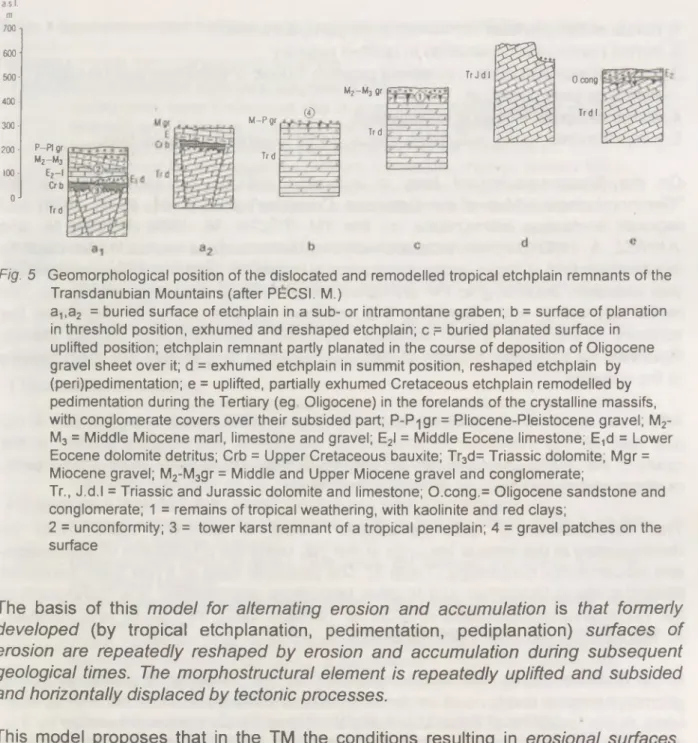
Fig. 5 Geomorphological position o f the dislocated and remodelled tropical etchplain remnants of the Transdanubian Mountains (after P(=CSI. M.)
a,,a2 = buried surface of etchplain in a sub- or intramontane graben; b = surface of planation in threshold position, exhumed and reshaped etchplain; c ,= buried planated surface in uplifted position; etchplain remnant partly planated in the course of deposition of Oligocene gravel sheet over it; d = exhumed etchplain in summit position, reshaped etchplain by (peri)pedimentation; e = uplifted, partially exhumed Cretaceous etchplain remodelled by pedimentation during the Tertiary (eg Oligocene) in the forelands of the crystalline massifs, with conglom erate covers over their subsided part; P-P^gr = Pliocene-Pleistocene gravel; Mr M3 = Middle Miocene marl, limestone and gravel; E2I = Middle Eocene limestone; E,d = Lower Eocene dolomite detritus; Crb = Upper Cretaceous bauxite; Tr3d= Triassic dolomite; M gr = Miocene gravel; M2-M3gr = Middle and Upper Miocene gravel and conglomerate;
T r, J.d.l = Triassic and Jurassic dolomite and limestone; O.cong.= Oligocene sandstone and conglomerate; 1 = remains of tropical weathering, with kaolinite and red clays;
2 = unconformity; 3 = tower karst remnant of a tropical peneplain; 4 = gravel patches on the surface
The basis of this m odel fo r alternating erosion and accum ulation is that form erly developed (by tropical etchplanation, pedimentation, pediplanation) surfaces o f erosion are repeatedly reshaped by erosion and accum ulation during subsequent geological tim es. The m orphostructural elem ent is repeatedly uplifted and subsided and horizontally displaced by tectonic processes.
This model proposes that in the TM the conditions resulting in erosional surfaces, due to tropical tower-karstic planation and accompanied by bauxite formation, were interrupted by the beginning of the Tertiary. This was mainly caused by changes in climate and in tectonic activities. During the Tertiary the bulk of the TM was repeatedly buried by tectonic subsidence under sedimentary sequences of different thickness. Some regions were partially or entirely elevated and exhumed twice or three times (during the Paleogene, Neogene and Quaternary). The karstic etchplain surface of Cretaceous origin was further eroded or buried under sediments during these repeated burial and exhumation events (e.g. by peripedimentation, formation of marine terraces, or alluvial fans). The TM, subdivided by grabens, contains five different groups of geomorphological surfaces:
1, horsts of etchplanation in summit level, partly exhumed;
2, buried horsts of etchplanation in uplifted position;
3, horsts of etchplanation in threshold position, buried or exhumed and reshaped, mainly by pedimentation;
4, buried etchplain in basins (cryptoplain);
5, peripediments, rocky pediments, glacis, partly covered by alluvial fans.
On the "Geomorphological Map of Hungary" (PEiCSI, M. 1976) and on the
"Geomorphological Map of the Danubian Countries" (PEzCSI, M. 1977, 1980) and regional landscape monographs on the TM (PECSI, M. 1988, PECSI, M. and JUHASZ, A. 1990) the term erosional-accum ulational surface evolution was used for the development of those geomorphological surfaces for which sufficient information was available, according to the principles and criteria of the proposed model. The model explaining and classifying the erosional surface evolution describes the surfaces of planation, buried surfaces, repeatedly exhumed and eroded planes, illustrates the polycyclic process of their superposition and reveals the main phases of the changes.
After three decades of observations in this field we think that the explanation is not just valid for the individual Intracarpathian Mountains, but may be applied in the cases of the Alpine-Dinarid mountain system, of some European ancient mountains, or of mountains and massifs of various continents.
The superposition of geomorphological levels of different ages could be demonstrated in the case of the units of the TM, using the procedures of denudation- and accumulation chronology (Table 1). The particular case of it has been published several times in Hungarian and in other languages, summarised in a monograph of the Transdanubian Mountains (P^CSI, M. 1970a,b, 1993; P^C S I, M. and JUHASZ, A. 1990; P£CSI, M. et al. 1985; SZ^KELY, A. 1972).
In the Gerecse, Buda, and Pilis Mountains (TM) the presence of almost all young geomorphological levels could be demonstrated in some sections, in addition to older ones. In the forelands of these Mountains the higher levels were represented by 3 or 4 Neogene marine terraces and deltas, by 1 to 2 foothill surfaces, and by 4 to 6 Quaternary fluvial terraces (Fig. 4). These geomorphological levels were protected against subsequent denudation by travertines capping them. Thus a reconstruction of long-term morphological evolution of geomorphological surfaces became feasible (PECSI, M. 1975, 1993; PECSI, M. et al. 1985).
The chronological classification of the geomorphological surfaces gave us a key to outline the geomorphic evolution of TM during the Cainozoic era.
Table 1 Geomorphological surfaces in the Hungarian mountains (P^CSI, M 1985) I REMNANTS OF OLD EROSION SURFACES
1 Remnants of Mesozoic etchplains with tower karst
- buried under lower Cretaceous clay or limestone in plateau position (in the E.
Bakony), or in threshold position (in the S. Bakony, Halimba) - buried by Eocene limestone in summit position (in the Buda Mts.)
- buried under Eocene limestone (at Gant, Vertes Mts.; Nylrad, Bakony Mts.) - buried under Oligocene sandstone (in the Buda Mts.) on different elevations - remnants of an exhumed etchplain in summit position (in the Buda Mts.,
Keszthely Mts.)
2 Remnants of Paleocene (and mostly Mesozoic) etchplains resculptured by Oligocene and Miocene pedimentation
- etchplain buried by Miocene gravel in summit position (at Farkasgyepu, Bakony Mts.)
- exhumed etchplain with patches of Miocene gravel in summit position (in the Gerecse Mts.)
II REMNANTS OF NEOGENE SURFACES OF PLANATION 1 Miocene raised beaches
- Surface with Karpatian conglomerate (in the northern foreland of Bakony Mts.) - Surface with Badenian littoral sandy-gravely limestone (in the Visegrad
and Borzsony Mts.)
- Sarmatian raised beach (in the Buda Mts., Balaton Upland) - Sarmatian pediment (in the Matra and Zemplen Mts.)
2 Pannonian (Upper Miocene) raised beaches and travertine horizons
- Lower Pannonian (Monacian) raised beach (at Soskut,. Diosd, in the Buda Mts.
and on the Balaton Uplands)
- Delta deposits (Precsakvarian- Csakvarian, the "Billege" and "Kalla" gravel on the Balaton Upland)
- Upper Pannonian (Pontian) raised beach - two surfaces (in the Bakony, Vertes and Buda Mts.).
- Upper Pannonian Csakvarian - Sumegian - Baltavarian) travertine occurring on two or three surfaces (Nos 10-12, at Nagyvazsony, Veszprem Plateau and Varpalota in the Bakony Mts., on Szechenyi- and Szabadsag-hill in the Buda Mts., two surfaces in the Gerecse Mts.)
- Upper Pannonian deltaic gravel (on Kopite hill in the Gerecse Mts.).
- Upper Pannonian-Pliocene basalt lava on pediment (subdivided into two levels?) (e.g. on Kabhegy and Somlo hills in South Bakony Mts.).
3 Uppermost Miocene - Pliocene pediments and travertine levels
- Mio-Pliocene pediment (Baltavarian) locally lowers down and forms a double surface of planation (between 360 and 220 m above sea level along the margins of the Transdanubian Mountains).
- Pliocene (Ruscinian-Csarnotian) travertine horizons on pediment (Nos 8 and 9;
in the Buda Mts., on the Kopite-hill at Sutto in the Gerecse Mts)
4 Upper Pliocene (Ruscinian - Csarnotian - Lower Villanvian) old alluvial fans and travertine horizons
- the Kemeneshcit - Ezusthegy - Kandiko gravel sheet
- terrace No VIII and travertine No 8 (in the Danube Bend Mts.) - terrace No VII and travertine No 7 (terrace hills of the Kemeneshat)
Ill QUATERNARY FLUVIAL TERRACES, ALLUVIAL FAN TERRACES AND TRAVERTINE HORIZONS
- Terrace No VI and travertine No 6 (Upper Villanyian)
- Terrace No V (Kislangian - Biharian) and travertine No 5 (Middle Biharian?, o f
reversed polarity)
- Terrace No IV (Middle Biharian, Vertesszolos phase), > 350 Ka, terrace and travertine are of normal polarity
- Terrace No Ilia and travertine No 3a (270 Ka) (in the Gerecse Mts.) - Terrace No lib (R3-W1) with travertine cover (120 to 70 Ka old) - Terrace No I la (W3), ca 26 to 12 Ka
- flood-plain No I and Holocene travertine No 1, from 11 Ka to present
Notes
1The genetic and topographic interpretation o f the concept of relief planation is rather diverse in the literature. Taking into consideration all definitions, both narrow and broad, it em erges that surfaces o f planation are considered (plane) surfaces o f considerable extent and low re lie f energy, over a stable or gently rising base. They are sculptured by processes o f destruction, and by a well-defined equilibrium o f uplift and degradation.
While some authors consider surfaces of planation to be results of sculpturing by a single erosive agent, others think that they are polygenetic; i.e. they result from the interaction of several processes the rates of which vary in tim e and space. Some authors believe that surfaces of planation are polygenetic also in space. Their com plex of form s includes not only surfaces of erosion, but also surfaces of accumulation.
2Davis assumed periods of long tectonic rest in the evolution of a mountain; the evolution during such a period produces a peneplain in the penultimate stage o f the cycle o f erosion, which subsequently undergoes repeated uplifting. On the mountain margins, at the base level of erosion, partial peneplains come into existence. W herever and w henever the periods of tectonic stillstands were not sufficiently long for the process of peneplanatioh to completely w ear away the relief formed during the previous cycle and subsequently uplifted, there, according to DAVIS, occur rem nants o f older peneplains at higher altitudes, in a stepwise arrangement.
3ln the Penckian interpretation o f stepped Rumpffldchen (piedmont benchlands) the initial surface is the "Prim arrum pf', but it may also be the Davisian peneplain, the "E ndrum pf, "Endpeneplane". As a result of arching, a process extending in area and accelerating in time, the longitudinal profiles of rivers are broken and the valley flanks gradually retreat and broaden at the expense of the higher surface.
The broadening arch em braces an increasingly wide area and thus and increasingly number of younger step surfaces are connected to the most highly elevated central arch. It is this system of stepwise repeated surfaces o f planation that was called "Piedmonttreppen" by an ever broadening area, rather than to a protracted and constant-rate uplift.
^Pediplains have usually been deduced from pedim ents (MAXSON, J.M: & G.H. ANDERSON 1935, HOWARD, A.D. 1942, MACKIN, J. H. 1970). It was in connection with these forms that American geologists and geom orphologists first cam e to attribute a decisive role to climatic factors. They interpreted as pediplains a num ber of extensively planated surfaces regarded as peneplains by Davis.
KING, L.C. (1962) has lately expressed the view that pediplanation is the most general form of surface lowering, substituting, as it were, the periplanation concept for the Davisian peneplain concept. In this way, however, KING (1949, 1962) gave an unduly broad context to the term pediplain, under which heading he included all the extensive planated surfaces of all continents as far back as the Cretaceous. In King's opinion pediplains are typical of semiarid tropical zones, but may also develop at lower intensities under m oderately humid conditions. He considers the differences between forms developed in arid, sem iarid and moderately humid climatic zones to control merely the intensity of development.
Another open question concerns the criteria o f identification for the pediplain, as a remnant of some planated surface outside the semiarid zone.
Tropical surfaces of planation, the concept of etchplanation
W AYLAND E.J. (1933) introduced the concept of etchplain, the etchplanation has been attributed to tropical deep weathering followed by removal (stripping) of the thick regolith zone. The idea has been elaborated and further developed by BUDEL, J. (1957), partly modified by BULLA B. (1958), LOUIS, H.
(1957) and som e others.
The concept, that extensive surfaces of erosion are most readily formed under humid or alternately humid and arid tropical climates, has become more and more widely accepted. The initiators of the theory explained the lowering and smoothing of large surfaces by extensive colloidal and subcolloidal weathering as well as by large scale slopewashing. Budel interpreted the evolution of the tropical surfaces of planation by developing the theory of "duplicate planation surfaces" (doppelte Einebnungsflachen).
In the zone of tropical slopewash, the surfaces are thickly covered with products of weathering, underlain by a less thoroughly smoothed but still hummocky relief of unweathered rock (e.g. granite).
This deeper interface is the basal front of planation, smoothed by weathering. Double planation takes place, on one hand, by slopewash on the surface cloak of weathering products (Spuloberfiache) and, on the other hand, by subsurface weathering on the deeper interface.
S p o ra d ica lly in the Carpathian Basin red clays occurring in subaeral Neogene deposits, in basin position, are interfingered by series of variegated clays, sandy clays, silts and sands. These sequences, under optim al geological and climatic conditions, could cover most of the Pliocene and the start of their form ation can be dated to the late Miocene (ca 2-5.6 Ma, P£CSI, M. 1985; P£CSI, M. et
al. 1988). The red clay together with the intercalated sequence are also products of cyclic climatic changes. They represent subtropical subhumid climate with alteration of warm-rainy and warm-dry seasons, succeeded by w arm semiarid climatic intervals preventing red clay formation but favouring pediment development.
References
BALLA, Z. 1988. Tertiary paieomagnetic data for the Carpatho-Pannonian region in the light of the Miocene rotation kinematics. - Foldtani Kozlony. 139. pp. 67-98.
BALDI, T. and K6KAY J. 1970. Die Tuffitfauna von Kismaros und das after des Borzsonyer Andesitvulkanismus. - Foldtani Kozlony. 100. pp. 274-284.
BALDI, T. 1982. A Karpat-Pannon rendszer tektonikai es osfoldrajzi fejlodese a kozepso tercierben. (49-19 millio ev kozott) (Tectonic and paleogeographic evolution of the Carpatho-Pannonian system in the middle Tertiary, between 49-19 Ma BP.). - Oslenytani Vit&k. 28. pp. 79-155.
BARDOSSY, Gy. 1973. Bauxitkepzodes es lemeztektonika (Bauxite formation and the plate tectonics). - Geonomia es banyaszat. MTA X. osztaly kdzlemenyek. 6/1-4. pp.
227-240.
BARDOSSY, Gy. 1977. Karsztbauxitok (Karstic bauxites). - Akademiai Kiado. Budapest, 413. p.
BREMER, H. 1986. Geomorphologie in den Tropen-Beobachtungen, Prozesse, Modelle. - Geookodynamik. 7. pp. 89-112.
BULLA, B. 1958. Bemerkungen zur Frage der Entstehung von Rumpfflachen. - Foldrajzi Frteslto. 7. 3. pp. 266-274.
BUDEL, J. 1957. Die "doppelten Einebnungsflachen" in feuchten Tropen. - Zeitschrift fur Geomorphologie. N.F. 1. pp. 201-228.
DAVIS, W.M. 1906. Geographical Essays. - Ginn, Boston. New edition; 1954, Dover, New York, 777 p.
DAVIS, W.M. 1922. Peneplains and the geographical cycle. - Bull, of Geol. Soc. of Amerika.
Baltimore. Vol. 33. pp. 587-598.
FOlOP, J. 1989. Bevezet6s, Magyarorszag geologiajaba (Introduction in Geology of Hungary). Akademiai Kiado, Budapest. 246 p.
GECZY, B. 1974. Lemeztektonika es a paleontologia (Plate tectonics and paleontology). - Foldtani kutat&sM IZ. pp. 17-20.
HAMOR, G. 1989. Paleogeographic reconstruction of Neogene plate movements in the Paratethyan realm. - Acta Geologica Hungarica. 27/12. pp. 5-21.
HORVATH, F. 1974. Application of plate tectonics to the Carpatho-Pannonian Region. - Acta Geologica Hungarica. 18. pp. 243-255.
HORVATH, F., STEGENA L. and GECZY, B. 1974. Szialikus es szimaikus ivkozi medencek (Sialic and simaic inter-arc basins).- Foldtani Kutatas. 17/3. pp. 11-16.
HOWARD, A.D. 1992. Pediment passes and the piedmont probleme. - Journal of Geomorphology. 5. pp. 1-31.
JASKC S. 1988. A Magyar-koz6phegyseg neogen rogszerkezete (The Neogene block structure of the Central Hungarian Range). - FOIdtani Kozlony. 118. pp. 325-332.
JAMBOR A. 1989. Review of the geology of the s.l. Pannonian formations of Hungary. - Acta Geologica Hungarica. 32. pp. 269-324.
JUHASZ A. 1988. A Bakonyvidek (The Bakony Region). - In: Pecsi, M. (ed.) A Dunantuli- kozephegyseg B. (Magyarorszag tajfoldrajza 6). Akademiai Kiado, Budapest, pp. 31-101.
JUHASZ, E., KORPAS, L. and BALOGH, A. 1995. Two hundred million years of karst history, Dachstein Limestone, Hungary. - Sedimentology. 42. pp. 473-489.
KAZMIzR, M. 1984. A Bakony horizontcilis elmozdulasa a paleocenben (Horizontal
displacement of the Bakony Mountains during the Paleocene). - Altalanos Foldtani Szemle. 20. pp. 53-101.
KING, L.C. 1949. The pediment landforms: some current problems. - Geological Magazine 86. pp. 245-250.
KING, L.C. 1962. The Morphologische Analyse. - Oliver & Boyd, Edinburgh and London.
699 p.
KRETZOI M.and PECSI M. 1982. A Pannoniai-medence pliocen es pleisztocen idoszakanak tagolasa . - Foldrajzi Kdzlem6nyek. 30. (106) 4. pp. 300-326.
KRETZOI, M. and PECSI, M. 1979. Pliocene and Pleistocene development and chronology of the Pannonian Basin. Acta Geologica Acad. Sci. Hung. 22. 1-4. pp. 3-33.
LUIS, A. 1957. Rumpfflachenproblem, Erosionszyklus und Klimamorphologie. - Geomorphologische Studien, Mahatschek Festschrift. Berlin, pp. 19-26.
MACKIN, J.H. 1970. Origin of Pediment in the Western United States. - In: Pecsi, M. (ed.) Problems of relief planation. (Studies in Geography in Hungary 8.) Akademiai Kiado, Budapest, pp. 85-105.
MAXON, J.M. and ANDERSON, G.H. 1935. Terminology of surface forms of the erosion cycle. - Journal o f Ecology. 43. pp. 88-96.
MARTON, P. and SZALAY, E. 1981. Mezozoic paleomagnetism of the Transdanubian Central Mountains and its tectonic implications. - Tectonophysics 72. pp. 129-140.
MINDSZENTY, A., KNAUER, J. and SZANTNER F. 1984. Az iharkuti bauxit uledekfoldtani jellegei es felhalmozodasi korulmenyei (Sedimentological features and the conditions of accumulation of the lharkut bauxite deposit). - Fdldtani Kdzlony. 114. pp. 19-48.
(English summary: pp. 41-44.)
McGEE, W.J. 1897. Sheetflood erosion. Bull, of Geological Society o f America. 8. pp.
87-112.
PENCK, W. 1924. Die Morphologische Analyse. - Stuttgart. 277 p.
PECSI M. 1963. Hegylabi (pediment) felszinek magyarorszagi kozephegysegekben. - (Summary in German: Fuftflachen in der Ungarischen Mittelgebirge). - Foldrajzi Kozlemenyek. 11. (87) 3. pp. 195-212.
PECSI, M. 1968. Denudational levels of the Hungarian Middle Mountains with special regard to pediment formation. - The geomorphological and terminology problems of the denudation features of middle mountains and their pediments (Symposium). Inst, of Geogr. Hung. Acad, of Sci., Budapest, pp. 24-36.
PECSI M. 1969a. A Balaton tagabb kornyekenek geomorfologiai terkepe (Geomorphological map of the broader environs of Lake Balaton). Kiserlet Magyarorszag attekinto (1:300 000-es) geomorfologiai faliterkepenek elkeszitesehez. - Foldrajzi
Kozlemenyek. 17. (93) 2. pp. 101-112.
PECSI M. 1969b. A hegysegek es eloteruk lepusztulasformainak kutatasarol rendezett nemzetkozi szimpozium fobb eredmenyei (The geomorphological and terminology problems of the denudation features of middle mountains and their pediments). - MTA Fold- es Banyaszati Tud. Oszt. Kozlemenyei. 2. pp. 319-321.
PECSI, M. 1970a. Geomorphological regions of Hungary. (Studies in Geography in Hungary 6). Akademiai Kiado, Budapest. 45 p.
PECSI, M. 1970b. Surfaces of planation in the Hungarian mountains and their relevance to pedimentation. - In: Pecsi, M. (ed.) Problems of relief planation. (Studies in
Geography in Hungary 8.) Akademiai Kiado, Budapest, pp. 29-40.
PECSI M. 1974. A Budai-hegyseg geomorfologiai kialakulasa, tekintettel hegytipusaira (Geomorphic evolution of the Buda Mountains and its mountain types). - Foldrajzi Fries ltd. 23. 2. pp. 181-192.
PECSI M. 1975. Geomorphological evolution of the Buda Highland (Hungary). - Studia Geomorphologica Carpatho-Balcanica, Krakow. 9. pp. 37-52.
PECSI M. 1976. Magyarorszag geomorfologiai terkepe (The geomorphological map of Hungary. 1:500 000. Legend). - Foldrajzi Kozlemenyek. 24. (100) 1-2. pp. 34-41.
(in Hungarian), pp. 42-44. (in English).
PECSI, M. 1977. Geomorphological map of the Carpathian and Balkan regions (1:1 000 000) + Part of the 1:1 000 000 scale geomorphological map of the
Carpathian region (Map). - Studia Geomorphologica Carpatho-Balcanica. 11.
Krakow, pp. 3-31.
PECSI, M. 1980. Erlauterung zur geomorphologischen Karte des "Atlasses der Donaulander". - Osterreichische Osthefte. 22. 2. pp. 141-167.
PECSI, M. 1983. A Dunantuli-kozephegyseg sasberc felszlnei es a denudacios kronologia (Horsts in the Transdanubian Mountains and denudation chronology). - Foldrajzi Frtesito 32. 3-4. pp. 504-505.
PECSI, M. 1987a. Domborzat (Relief). - In: Pecsi, M. (ed.) A Dunantuli-kozephegyseg, A.
(Magyarorszag tajfoldrajza 5.) Akademiai Kiado, Budapest, pp. 140-176.
PECSI, M. 1987b. Domborzatfejlodes es a geomorfologiai szintek korrelacioja (Relief evolution and correlation of geomorphological levels). In: A Dunantuli-
kozephegyseg A. (Magyarorszag tajfoldrajza 5.) - Akademiai Kiado, Budapest, pp.
131-139.
PECSI, M. 1988. Geomorfologiai szintek kora a Magyar-kozephegysegben. (Summary in English: Age of geomorphological surfaces in the Hungarian Mountains.) - Foldrajzi Kozlemenyek. 36. (112) 1-2. pp. 28-41.
PECSI, M. 1993. Landform evolution model of alternating erosional-accumulational
geomorphic surfaces. - Indian Journal of Landscape Systems and Ecological Studies.
16. 2. 1-7.
PfiCSI, M. and JUHASZ, A. (eds) 1990. Excursion Guide. Symposium and Field Excursion in Bakony Mountains. First Hungarian-Slovene Geographical Seminar. 27-28. Sept.
1990. Geogr. Res. Inst. Hung. Acad. Sci., Budapest. 65 p.
PECSI, M., SCHEUER, GY., SCHWEITZER, F„ HAHN, GY. and PEVZNER, M.A. 1985.
Neogene-Quaternary geomorphological surfaces in the Hungarian Mountains. - In:
Kretzoi, M. and Pecsi, M. (eds) Problems of the Neogene and Quaternary. (Studies in geography in Hungary 19.) Akademiai Kiado, Budapest, pp. 51-63.
PECSI, M., SCHEUER, GY. and SCHWEITZER, F. 1988. Neogene and Quaternary geomorphological surfaces and lithostratigraphical units in the Transdanubian Mountains. - In: Pecsi, M. and Starkel, L. (eds) Paleogeography of Carpathian Regions. Geogr. Res. Inst. Hung. Acad. Sci., Budapest, pp. 11-41.
PECSI, M.-SZILARD, J. 1970. Planated surfaces: Principal problems of research and
terminology. - In: Pecsi, M. (ed.) Problems of relief planation (Studies in geography in Hungary 8.) Akademiai Kiado, Budapest, pp. 13-27.
SAG, L. and P£CSI, M. 1987. Kainozoikum (Cenozoic). In: A Dunantuli-kozephegyseg A.
(Magyarorszag tajfoldrajza 5.). Akademiai Kiado, Budapest, pp. 75-122.
SCHWEITZER, F. and SCHEUER, GY. 1988. A Gerecse es a Budai-hegyseg, edesvizi meszkoosszletei (Travertines in the Gerecse and Buda Hills). - Foldrajzi
Tanulmanyok. 20. Akademiai Kiado, Budapest. 129 p.
STEGENA, L. and HORVATH, F. 1978. Kritikus tethysi es pannon tektonika. - Budapest, Foldtani Kozlony. 108. pp. 149-157.
SZEiKELY, A. 1972. Az elegyengetett felszinek tlpusainak rendszere magyarorszagi
peldakon. (Summary in German and in English: A system of planation surface type - on examples from Hungary). - Foldrajzi K6zlem6nyek 20. 1. pp. 43-59.
WAYLAND, E.J. 1937. Peneplains and some erosional platforms. - Bulletin geological Surawy Uganda. Ann. rest. Bull. 1. pp. 77-79.
WEIN, GY. 1977. Magyarorszag neogen elotti szerkezetfoldtani fejlodesenek osszefoglalasa (A review of pre-Neogene tectonics in Hungary) - Foldrajzi Kozlemenyek. 25. pp.
302-328.
WEIN, GY. 1978. A Karpat-medence kialakulasanak vazlata (An outline of the evolution of the Carpathian Basin). - Alt. Foldtani Szemle. 11. pp. 5-34.
Geomorphology And Global Habitability
Ba k e r, V ic to r R.
Department of Geosciences, University of Arizona Tucson, AZ 85721 USA
*
Much current global change and natural hazard research is of limited value because of an overemphasis on prediction through idealized conceptual models predicated upon unverifed assumptions. To understand environmental change one needs scientific experience of such change as a complement to the conceptualization of that change. Geomorphology, a major science of natural experience, has largely been marginalized by the value systems imposed by the earth-system science emphasis of modern global change research.
Current international science initiatives to understand global change focus on predictionachieved through mathematical models. It is assumed that this approach will provide the essential basis for policy- and decision-making to mitigate threats to global habitability. Because such models are strictly unverifiable in the real world, accurate foreknowledge of the future is ari impossible goal. As a practical matter, decisions will be made on the basis of perception, grounded in the available experience of change. The greatest repository of Earth experience capable of stimulating human perception is the Earth's surface and evidence of its geomorphological change. In studying this record, geomorphologists employ synthetic reasoning, using retroductive (causal) inference, to interpret indices (signs) of processes that reveal the natural patterns (habits) of Earth experience through time and space. Discovery of anomalous phenomena leads to the need for revising prior conceptualizations (models), refomulating them to be more in accord with reality. An exam ple is the recent discovery in tropical river paleoflood records that large floods may be preferentially clustered in recent decades. If corroborated by further study, this may indicate an influence of global greenhouse warming on monsoonal circulation and tropical storms. Such change could have profound implications for global habitability.
Introduction
Human civilization has long been at risk from environmental change. Droughts, floods, and soil degradation have all imperiled the infrastructure of past societies.
Ancient civilizations of once-fertile river valleys have been destroyed by the direct and indirect consequences of these environmental changes (THOMAS, W.L. 1956).
Against a background of continuing massive transformation of the Earth by human action (TURNER, B.L. II et al. 1990), in recent years scientific concern with "global change" has increasingly focused on issues such as greenhouse watming, ozone depletion, desertification, and deforestation. International programs for "earth-system science" and "geosphere-biosphere" study are being actively promoted for achieving solutions to these problems. In the dozen years since their inception (PERRY, J.S.
1991) these programs have now moved to the forefront of concern by the international science community. For the United States research strategies have been established to achieve an understanding of global change (Committee on Global Change 1990). The primary strategy of "integrated modeling of the earth system" is being implemented into policy for the funding of U.S. science. The goal of the 1994 U.S. Global Change Research Program (Committee on Earth Sciences
1993) is "to produce predictive understanding of the earth system to support national and international policy-making activities across a broad spectrum of global, national, and regional environmental issues."
A great weakness of various initiatives in scientific global change research and in the assessment of natural hazards, such as floods, is their overem phasis on prediction through idealized conceptual models predicated upon unverified assumptions. The problems of human habitability on planet Earth center on the reality of immense populations of Asians, Africans and South Americans, who live on lands sensitive to continental environmental change. Coping with this change requires not merely ideal model predictions of future climate; it requires a profound experience-based scientific understanding of such change. Broad-scale experiential science of real, continental land-water change is the natural work of geomorphologists and surficial geologists.
Their efforts may serve some role in providing information on landscape process changes as a source of testing models for predicting such changes. However, by far the more imponant goal of their work is to discover unforeseen workings of the natural and human-modified that will require new or revised models (hypotheses) for their explanation. I am concerned that this latter goal is being impeded by the present overemphasis on predicting the "earth system" and "reducing the uncertainties" in that predictive enterprise. Reasons for this concern, and our possible response as geomorphologists will be explored in this essay.
The Earth-system Science Approach
Human beings live on the land surface o f the Earth. Their existence is interwoven with and dependent upon that surface which they inhabit. It was for this reason that
the original designation of the global science initiatives of recent years began with the name "global habitability" (GOODY, R. 1982). The original name, now superseded by "global change" and "earth-system science", reminds us of the real reason that such science is needed for the future. Humankind desires a habitable planet for its long-term existence. This application is the desired outcome of the science that society is asked to support with substantial resources that might otherwise be spent on many worthwhile nonscientific projects. It is well to remember that while "...science expects autonomy and support ... society expects substantial benefits..." (BYERLY, R. and PIELKE, R.A. 1995). The U.S. Global Change Research Program was initiated in 1989 to provide a strategy to enhance the relevant research activities of various federal agencies. The program's initial goal was stated, "...to provide a sound scientific basis for national and international decision making on global change issues" (Committee on Earth Sciences 1989). By 1994 this goal had been restated, "... to produce a predictive understanding of the earth system to support national and intentional policymaking activities across a broad spectrum of global, national, and regional environmental issues" (MOLNIA, B.F. 1994). MAHLMAN, J.D. (1989, p.71) provided the following succinct description of the program:
Through careful, long-term research on observation, modeling, and analysis, our scientific uncertainties will decrease and our confidence for predicting details of the climate system and its changes will gradually improve... the societal need for accurate and detailed climate predictions will increase... (and the) effort to meet these societal challenges will require... the world scientific community in a sustained effort spanning decades.
In 1986 the Intentional Council of Scientific Unions (ICSU) established the International Geosphere-Biosphere Programme (IGBP). This international effort has taken up the same themes of earth-system science, predictive modeling, and reducing uncertainties (IG BP,1992). For example, various climate-model simulations of the idealized "earth system" are developed to show near-future changes in atmospheric parameters caused by human-induced increases in radiatively active gases (HOUGHTON, J.T. et al. 1990). Some of these climate modeling simulations have already indicated the theoretical possibility for alarming impacts of an increasing greenhouse effect on regional climatological and hydrological factors, including droughts and flood-causing storms (HANSEN, J. et al. 1989). However, the various modeling scenarios are also subject to considerable debate concerning the inherent uncertainties which may limit their use as a basis for what could be extremely expensive societal response (SCHLESINGER, M.E. and JIANG, X. 1991).
The debate poses the following dilemma: Should society take drastic action to avert a predicted calamity or should it wait until uncertainties in the prediction are reduced to a comfortable level, at which time the calamitous consequences may be irrevocable?