UN CORRECTED PR
OOF
https://doi.org/10.1007/s00531-018-1637-3 ORIGINAL PAPER
Evidences for pre-orogenic passive-margin extension in a Cretaceous fold-and-thrust belt on the basis of combined seismic and field data (western Transdanubian Range, Hungary)
Gábor Héja1 · Szilvia Kövér1 · Gábor Csillag1 · András Németh2 · László Fodor1,3
Received: 27 March 2018 / Accepted: 9 July 2018
© Springer-Verlag GmbH Germany, part of Springer Nature 2018
Abstract
Combined sedimentological and structural analysis was carried out in the field and on 2D seismic reflection profiles to recognize pre-orogenic structures in a Cretaceous fold-and-thrust belt. Detailed field observations were made in the Kesz- thely Hills, Western Hungary, while 2D seismic interpretation was carried out in the neighbouring Zala Basin. As a result, a fault-controlled intraplatform basin system was identified by a detailed analysis of bounding faults, and related outcrop- scale structures. The Norian–Rhaetian (227–201.3 Ma) synsedimentary faulting was associated with talus breccia forma- tion, small-scale faulting, and dyke formation, in addition to slumping and other soft-sediment deformations. Based on the distribution of talus breccia, WNW–ESE-trending map-scale normal faults were identified in the Keszthely Hills, which is in agreement with the directly observed outcrop-scale synsedimentary faults. On seismic sections, similar WNW- or NW- trending Late Triassic normal faults were identified based on thickness variations of the syn-rift sediments and the presence of wedge-shaped bodies of talus breccia. Normal faulting occurred already in the Norian, and extensional tectonics was active through the Early and Middle Jurassic. The Late Triassic grabens of the western Transdanubian Range could be correlated with those in western part of the Southern Alps, and the Bajuvaric nappe system of the Northern Calcareous Alps. These grabens were situated on the proximal Adriatic margin, and they represent the first sign of the Alpine Tethys rifting. The locus of extension was laterally migrated westward, towards the distal Adriatic margin during Early and Middle Jurassic.
Keywords Pre-orogenic extension · Synsedimentary deformation · Norian tectonics · Alpine Tethys rifting · Triassic paleogeography
Introduction
Pre-orogenic structures have an increasing role in the structural interpretation of thrust and fold belts (But- ler et al. 2006). Several balanced sections show that the
retro-deformed original stratigraphy cannot be considered as a layer-cake and prominent pre-orogenic deformation can be recognized (Perez et al. 2016; Yagupsky et al. 2008;
De Vicente et al. 2009). Identification, investigation, and understanding the structural geometry, fault pattern, and deformation style of these pre-orogenic structures have pri- mary importance, since these early structures may have a significant effect on the final geometry of subsequent folding and thrusting.
In many cases, structural inheritance is responsible for the development of backthrusts, young-on-older thrust, and compressional structures non-perpendicular to the shorten- ing, such as oblique or lateral ramps (Bonini et al. 2012;
Pace et al. 2014; Ustaszewski and Schmid 2006).
In most cases, pre-orogenic faults develop during the passive-margin evolution, before the onset of shortening.
However, normal faults can also be re-activated or newly evolve later, during foreland basin evolution, due to the
Electronic supplementary material The online version of this article (https ://doi.org/10.1007/s0053 1-018-1637-3) contains supplementary material, which is available to authorized users.
* Gábor Héja
hejagabor@hotmail.com
1 MTA-ELTE Geological, Geophysical and Space Science Research Group of the Hungarian Academy of Sciences at Eötvös University, Budapest, Hungary
2 MOL Hungarian Oil and Gas Plc., Budapest, Hungary
3 MTA-ELTE Volcanology Research Group of the Hungarian Academy of Sciences, Budapest, Hungary
AQ1 1
2 3 4
5
6 7
8 9 10 11 12 13 14 15 16 17 18 19 20 21 22
23 24
25
26 27 28
29 30 31 32 33 34 35 36 37 38 39 40 41 42 43 44 45 46 A1
A2 A3 A4 A5 A6 A7 A8 A9 A10 A11
UN CORRECTED PR
OOF
Bratislava
Budapest LakeBalato
n
Zagreb Milano
Wien
Ljubljana
Hurbanovo-Diósjenő Fault
ne Zo utl Fa an ri ga un -H id M Periadriatic
Fault Periadriatic Fault Periadriatic Fault
study area, Fig. 1B
Guidicarie Faul t
SEMP deformed Europe
remnants of Penninic Ocean remnants of Neotethys Ocean
Austroalpine Nappes in general Suture of Eoalpine intracontinental subduction Late Triassic platforms Areas dominated by Norian - Rheatian intraplatform basins T2 basins reactivated in T3
100 km
Zk-1
R-3 Zk-1 Nb-2
Szgy1
K-25 Hév-7 K-24 Hév-6K-19
Cs-7 Rzt-1 Rzt-3Rz-4
Várt-1
Vá-3 Vá-2
Bet-1 Uzst-1 Zszt-3
Zu-2
Zu-1 Zl-1
Zl-3 Keh-1
Kd-3K-8 K-12 Zcs-2 Zcs-1
Kd-1 Mis-1 Kd-2
Mis-2
Pa-1 Pa-2
Zl-4
L1
L6 L3
L5 L2
L4
Carnian Ederics Lst. (platform) Carnian Marl and Limestone (basin) Upper Carnian-Norian Hauptdolomit (platform) Upper Norian Rezi Dolomite (basin) Upper Norian-Rhaetian Kössen Marl (basin)
Carnian Sédvölgy Dolomite (platform) N 5 km
Miocene - Pliocene basalt Late Miocene (Pannonian) sediments
KESZTHEL Y HILLS ZALA BASIN
SOUTHERN BAKONY
Pa-2
Trace of 2D seismic sections Trace of 2D seismic section (Fig. 5)
Wells, that reached the pre-Senonian basement Fig.5a
Fig. 7b Fig. 7c
L1L2 L3L4 L5
Csókakő quarry Pilikán quarry
Gyenesdiás eastern quarries Felsőhegy quarry Kőmell Cliff
Gyenesdiás western quarries L6
Senonian Miocene
Jurassic suoecaterCciozoneC
ZALA BASIN KESZTHELY HILLS
nainraCnairoN
Padkő Mb.
Rezi Dolomite Kössen Marl
Ederics Limestone Sédvölgy Dolomite
Sándorhegy F.
Csicsó Marl Mb.
Mencshely Marl Mb.
Nosztor Limestone Mb.
Sevatian
Alaunian
Lacian
Tuvalian Julian
naiteahR
Jurassic and Lower Cretaceous Dachstein Limestone
Cserszegtomaj Kaolinite
Hauptdolomit
L7
L7 Budai Hill quarry other units
Fig. 5b
LAKE BAL ATON Várvölgy Vállus
Neme svita
Vonyarcvashegy Gyenesdiás KESZTHELY Cserszegtomaj Rezi
Balatongyörök Lesencetomaj
Hévíz
A
B
C
e e
e fa b
d
e bgeg c
h
h
h d
Middle Triassic magnetisation directions Late Triassic magnetisation directions Jurassic magnetisation directions
TISZA-DÁCI A
DINARIDES D o l o m i t e s
Lombardian Basin
TRANSDANUBIANRANGE
undeformed ADRIA
undeformed EUROPE
WESTERN
CARPATHIANS
S O U T H E R N A L P S
A B
B’
A’
Veszprém Marl 47.5°
45°
10° 15°
45°
47.5°
10° 15°
Description of seismic facies Correlation with lithology
low to high amplitude, reflectors laterally fades away very low to low amplitude short pale reflectors medium to high amplitude continuous reflectores low to high amplitude
continuous reflectors Jurassic - L. Cretaceous succession Kössen Marl
Hauptdolomit and Rezi Dolomite Dachstein and Kardosrét Limestone Veszprém Marl
1 2 3 4
D
UN CORRECTED PR
OOF
flexure of the subducting lower plate (Butler et al. 2006;
Billi and Salvini 2003).
Investigation of pre-orogenic normal faults is often com- plicated, since such structures can be strongly overprinted by later compressional deformation in thrust belts. However, pre-orogenic synsedimentary structures are often accompa- nied by secondary features, which may survive the basin inversion. Such features are abrupt facies changes, reflect- ing significant changes in depositional environments (e.g., deepening) and characteristic sediments and sedimentary structures related to fault activity. However, synsedimen- tary extension creates facies change only in those cases, if the rate of extension-related subsidence of the hanging wall is significantly larger than the rate of deposition. If the deposition keeps pace with the subsidence of the hanging wall, both the hanging wall and the footwall can have the same environment, and thus, the fault cannot be identified just on the basis of facies changes. In this case, thickness variation of the pre-orogenic succession can be an indicator of synsedimentary normal faulting. The most characteristic fault-related sediments are coarse-grained talus-cone brec- cias (Ortner et al. 2008); moreover, synsedimentary fault movements are often associated with soft-sediment deforma- tion (Bergerat et al. 2011).
Pre-orogenic extension in the study area was already supposed by Csillag et al. (1995), based on the presence of coarse breccias and facies distribution. However, they neither determined the exact position of faults nor charac- terized the fault pattern or the stress field. In our study, we demonstrate how the combined sedimentological and struc- tural observations, fault-slip analysis, geological map inter- pretations, and 2D seismic sections can be used to identify and characterize pre-orogenic structures in a poorly outcrop- ping area. The study area is the westernmost outcropping part of the Transdanubian Range (Keszthely Hills) and its western continuation submerged below the Cenozoic cover of the Zala basin (Fig. 1a, b). The aim of this paper is to describe the Late Triassic extensional structures, hitherto frequently cited but very rarely characterized. Our results
can contribute to understanding the early phase of passive- margin evolution of the study area.
Geological setting
The Transdanubian Range was part of the Adriatic plate, which was situated between the Neotethys and the Alpine Tethys (Mandl 2000; Csontos and Vörös 2004; Schmid et al.
2008). First phase of rifting during Anisian was related to the opening of the western branch of the Neotethys (Haas et al. 1995; Budai and Vörös 2006), while rifting of the Alpine Tethys initiated during Late Triassic and Early Juras- sic (Bertotti et al. 1993; Decarlis et al. 2017).
The following deformations of the Transdanubian Range are related to the closure of these oceans. The partial closure of the western part of the Neotethys led to the folding in the study area during the Albian–Coniacian (Fodor et al. 2017).
These structures are discordantly covered by the Senonian strata, and they represent one of the most significant defor- mations of the Transdanubian Range.
After the final subduction of Alpine Tethys, collision and continental subduction of European plate below Adria occurred during the Late Paleogene. This event led to the eastward extrusion of ALCAPA unit along the Periadriatic Fault (Schmid et al. 2008) (Fig. 1a). The eastern continu- ation of this structure is the Mid-Hungarian shear-zone, which is located directly south of study area (Balla 1984;
Csontos and Nagymarosy 1998; Fodor et al. 1999).
The Pannonian back-arc basin system was formed dur- ing the Miocene, in the hinterland of this subduction (Tari 1994; Horváth et al. 2015; Balázs et al. 2016). Therefore, the study area was affected by strong extension, and thus, the studied Keszthely Hills are parts of a Miocene extensional horst bounded by normal faults and grabens, such as the Zala Basin (Fodor et al. 2013).
As it was briefly summarized above, the geodynamic evolution of the study area was affected by the opening and closure of two distinct oceanic systems, and accordingly, it has a complex stratigraphy. In this paper, we focus on the Late Triassic and Jurassic synsedimentary deformations, and therefore, we describe only the coeval sediments in detail.
Late Triassic‑to‑Early Cretaceous stratigraphy
The oldest known formation of the study area is Carnian in age (Haas et al. 2014). The Carnian basinal marl and lime- stone (Veszprém Marl and Sándorhegy F.) are laterally inter- fingering with the coeval carbonate platform (Ederics For- mation) (Csillag et al. 1995), which was partly dolomitized (Sédvölgy Dolomite) (Haas et al. 2014).
From the end of the Carnian, the Hauptdolomit Forma- tion was deposited (Fig. 1c). The formation is built up by
Fig. 1 a Position of the study area on the simplified paleogeographic map of the Alps (after Schmid et al. 2008; Goričan et al. 2012; Haas 2002). Austroalpine cover nappes were coloured on the basis of their dominant Late Triassic depositional environment (basin/platform).
Yellow arrows show the Middle, Late Triassic, and Jurassic mag- netization directions based on the measurements of a Becke and Mauritsch (1985), b Channell et al. (1990), c Gallet et al. (1998), d Heer (1982), e Mauritsch (1980), f Mauritsch and Becke (1987), g Mauritsch and Frisch (1978), and h Márton and Márton (1983). b Geological map of the study area based on Budai et el. (1999b) and Császár and Gyalog (1982). For coordinates of the investigated out- crops, see Table 1. c Stratigraphy of the Keszthely Hills and the Zala Basin based on Csillag et al. (1995) and Kőrössy (1988). Formations are shown in approximately proportion to thickness. d Seismic facies types of the pre-Senonian basement of the study area
◂
AQ2
AQ3 47 48 49 50 51 52 53 54 55 56 57 58 59 60 61 62 63 64 65 66 67 68 69 70 71 72 73 74 75 76 77 78 79 80 81 82 83 84 85
86 87
88
89 90 91 92 93 94 95 96 97 98 99 100 101 102 103 104 105 106 107 108 109 110 111 112 113 114 115 116 117 118 119 120 121 122 123 124
125
126 127 128 129 130 131 132 133
UN CORRECTED PR
thin-layered bituminous dolomite in the study area. Occa-
OOF
sionally, stromatolite intercalations occur. The formation was deposited in ultra-back-reef–lagoon environment (Fruth and Scherreiks 1984).
From the end of Middle Norian (Budai and Kovács 1986), extension-related intraplatform basins were formed, which were filled up by late Middle–Upper Norian Rezi Dolomite and Rhaetian Kössen Marl (Haas 1993; Csillag et al. 1995;
Budai and Koloszár 1987; Budai et al. 1999a). Budai and Koloszár (1987) subdivided the Rezi Formation into three members. The lower member is represented by dark-grey cherty bituminous-laminated dolomite. The middle member is made up by the alternation thin-layered and thick-layered dolomite, which often contains re-deposited green algae fragments (Fig. 1c). This middle member was interpreted as a platform progradation tongue of the coeval platform.
The upper member is similar to the lower member. Another dolomite breccia lithofacies of the Rezi Dolomit with re- deposited platform-originated blocks were identified in the Csókakő quarry (L1) (Csillag et al. 1995).
According to Csillag et al. (1995), the Rezi Dolomite was deposited in a synsedimentary half-graben in the Keszthely Hills. The dolomite breccia represents the fault-bounded talus breccia of a synsedimentary normal fault. On the tectonically controlled elevated areas, carbonate platform environment still persisted. These areas are represented by the footwall of major normal fault bordering the Rezi half- graben, and the opposite edge of the half-graben (Csillag et al. 1995). From the edge of the half-graben, the propaga- tion of platform occurred. Nevertheless, this model does not specify the exact geometry of the basin and the controlling normal faults.
The Rhaetian Kössen Marl Formation (Fig. 1c) is poorly exposed; therefore, it is rather known from wells (Haas 1993). It is made up by dark-grey-to-black shales with high organic matter content. Thin-bedded limestone intercalations occur frequently within the shale; it is strongly folded due to slumping (Budai and Koloszár 1987).
The younger Mesozoic formations were eroded in the Keszthely Hills, partly, due to the mid-Cretaceous folding
(Fig. 1c). However, in the western subsurface continuation of the Keszthely Hills (eastern Zala Basin) and in the South- ern Bakony (NE to Keszthely Hills), the younger members of the pre-Senonian succession could be traced. The Kössen Marl is interfingering with the limestone of the coeval Rhae- tian Dachstein platform towards NE, based on well data;
consequently, the Kössen Marl pinches out NE-ward (Haas 1993, 2002). Platform progradation of the few 100 m-thick Dachstein Formation can also be observed above the Kös- sen Marl in several wells of the Zala Basin (Kőrössy 1988).
The carbonate platform environment still existed in ear- liest Jurassic (Kardosrét Fm.); however, it drowned in the beginning of Sinemurian, due to extension-related strong subsidence (Fig. 1c). This extension also created horsts and grabens (Vörös and Galácz 1998). There was hiatus, or just condensed sedimentation on the top of the submarine horsts, while thin, pelagic formations deposited with variable lithol- ogy in the grabens (Haas et al. 1984).
The Lower Jurassic succession is characterized by pelagic red nodular limestone and grey cherty limestone (Haas et al.
1984; Vörös and Galácz 1998). During the Middle Juras- sic, cherty limestone and radiolarites were deposited. The Upper Jurassic formations seal both the pre-existing horsts and the grabens (Vörös and Galácz 1998; Haas et al. 1984).
This Upper Jurassic succession is made up by red nodular limestone and white pelagic cherty limestone. The deposi- tion of the latter formation is lasted till the Early Cretaceous.
From the Barremian to the Aptian silty sandy pelagic marl, and then shallow marine limestone were deposited (Haas et al. 1984).
Methods
In the eastern part of the study area (Keszthely Hills), Triassic rocks are exposed; their microtectonic and basic carbonate sedimentologic field observations were carried out in dolomite quarries. To help the readers, the quarries were marked by numbers (see after the names of quarries in Sect. 4, and on map Fig. 1b). The measured structural data were illustrated on stereoplots. In the adjacent Zala Basin, Mesozoic basement is under thick Cenozoic cover. There, the investigation of Mesozoic basement is possible based on seismic data.
Stereoplots
Several types of structural data were measured in outcrops of the Keszthely Hills, which were plotted by the software of Angelier (1990) (for legend, see Fig. 2d). Fault-slip data rarely contained slicken lines, in most cases, just the fault planes were measurable. Therefore, fault-slip inver- sion was not carried out, since at least four slicken line
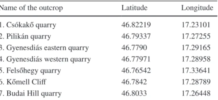
Table 1 Location of the investigated outcrops
Projection datum is WGS84
Name of the outcrop Latitude Longitude
1. Csókakő quarry 46.82219 17.23101
2. Pilikán quarry 46.79337 17.27255
3. Gyenesdiás eastern quarry 46.7790 17.29165 4. Gyenesdiás western quarry 46.77971 17.28958
5. Felsőhegy quarry 46.76542 17.33641
6. Kőmell Cliff 46.7842 17.28789
7. Budai Hill quarry 46.8033 17.26448
AQ4 134
135 136 137 138 139 140 141 142 143 144 145 146 147 148 149 150 151 152 153 154 155 156 157 158 159 160 161 162 163 164 165 166 167 168 169 170 171 172 173
174 175 176 177 178 179 180 181 182 183 184 185 186 187 188 189 190 191 192 193 194 195 196 197 198 199 200 201 202 203
204
205 206 207 208 209 210 211 212 213 214
215
216 217 218 219 220 221
UN CORRECTED PR
OOF
required for the calculation (Angelier 1990). Stress axes were estimated based on conjugate faults. Tilt test was carried out by the module of “Rotilt” (Angelier 1990), if the beds had a significant dip. The basic assumption was that tilting of the strata is mostly the result of Cretaceous folding. Pre-orogenic structures were back-tilted by the dip of the beds, to get a better view on the original geom- etry. Consequently, tilt test gave a relative chronology with respect to tilting/folding.
Seismic sections
The seismic sections were acquired and processed by GES Geophysical Services Ltd. in 2001 using vibroseis source with 8–90 Hz sweep frequency. Coverage of 100 and 12.5 m distance between CDPs ensured the proper lateral resolution and a good signal/noise ratio. These acquisition parameters represented an advanced technology that time. This facili- tated a good image of basement structures. The processing
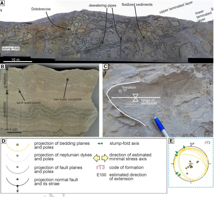
Fig. 2 Eastern wall of the Csókakő quarry (L1). a Dolomitic breccia and two laminated dolomite intercalations. Fluidized zones cross cut the dolomite breccia and layers; b cm-scale slump folds with mm-
scale microfolds; c lineation is visible parallel to the slump-fold axis;
d legend for the stereonets; e stereonet of the measured slump-fold axes and bedding
222 223 224 225 226 227 228 229 230
231
232 233 234 235 236 237 238
UN CORRECTED PR
OOF
was standard time processing including a challenging static correction due to hilly terrain, DMO correction, and post- stack migration. The featured sections were not time-depth converted and the vertical scales show two ways which travel time is second.
Field observations
Csókakő quarry (L1 on Fig. 1b)
Upper Norian Rezi Dolomite is exposed in the Csókakő quarry (L1 on Fig. 1b), which is covered by Upper Miocene (Pannonian) conglomerate and sand. The most spectacular part of the quarry is its eastern wall (Fig. 2a). Two main facies types of the Rezi Dolomite are visible here: thin-lay- ered–laminated dolomite and dolomite breccia. Laminated dolomite occurs in the northern part of the eastern wall with sub-horizontal dip. Southward-thickening dolomite breccia tongues can be observed between the laminated dolomite layers, further south. These strata dip already moderately toward NNE. Further south, the laminated dolomite inter- calations pinch out, and in the southern edge of the quarry, only massive dolomite breccia is present.
The laminated unit is characterized by dark grey, strongly bituminous dolomite (Fig. 2a, b, c). Occasionally, sand-sized dolomite lithoclasts can be observed at the base of the lami- nated dolomite layers (Fig. 2b). These layers show normal gradation (Fig. 2b). Slide and slumps are common in the laminated dolomite: slumps occur mostly in the northern part, while slide scarps are more common in the middle and southern parts of the eastern wall. Slump folds shows symmetric to slightly asymmetric geometry; the axes of the slump folds show a significant dispersion, neverthe- less, WNW trend is most frequent (Fig. 2e). Lineation was observed on the slump folds, which is parallel to the fold axis (Fig. 2b, c).
The clasts of the dolomite breccia are up to few meters in size (Fig. 2a). They are thick-bedded, white- or light-grey boulders, which often contain green algae, molluscs, and gastropods. Stromatolitic, intertidal dolomite represents another clast type of this dolomite breccia.
The matrix of the dolomite breccia is gradually chang- ing south ward. In the northern, distal part of the breccia tongues, the matrix of this dolomite breccia is laminated dolomite. The laminated dolomite matrix is intensively deformed into chaotic folds between the re-deposited large dolomite blocks. In contrast of that, in the southern part of the breccia tongues, the matrix is made up by massive, light-grey dolomite, containing the same platform-originated fossils as the fossil-rich clasts of the dolomite breccia.
Two laminated dolomite intercalations are visible between the dolomite breccia tongues in the middle part of
the eastern wall (Fig. 2a). The gently NNE-dipping beds are cross cut by several, few centimetre wide zones (Fig. 2a).
The infill of these zones is small dolomite breccia clasts sitting in dolomite matrix.
The lower laminated dolomite layer is interrupted by a 5–10 m-wide sub-vertical collapsed zone, where chaotic, dark-grey dolomite is mixed with huge, light-grey dolomite blocks (Fig. 2a). The dark-grey dolomite probably originally represented the same material as the laminated one, but its original sedimentary features were destroyed (strongly deformed) later; therefore, the original lamination cannot be recognized there (Fig. 2a). The upper laminated dolomite intercalation is down bending and thickened above this zone (Fig. 2a).
Very similar, up to meter-sized dolomite blocks were observed in massive dolomite matrix at the Kőmell Cliff (L6 on Fig. 1b). Poor outcrop conditions does not permit detailed description (Fig. 1b).
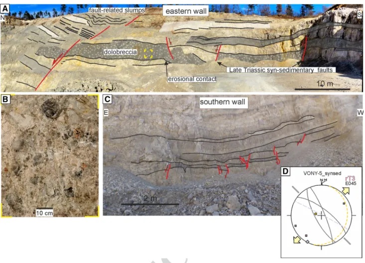
Pilikán quarry (L2 on Fig. 1b)
Thinly bedded to laminated, dark-grey, bituminous dolo- mite (Rezi Fm.) crops out in the Pilikán quarry (L2). In the southeastern corner of the quarry, a 3 m-thick dolomite breccia intercalation was observed (Fig. 3a). The clasts are significantly smaller than those of the previous outcrops;
their maximum size is just few dm (Fig. 3b). The contact of the breccia bed and the underlying dolomite is a wavy ero- sional surface. It is dissected by a number of normal faults (Fig. 3a). The offset of these faults decreasing upward, and finally, they are sealed by cover beds, without any flexure.
In the upper part of the eastern wall meter-sized symmetric slump folds occur (Fig. 3a). The thickness variations along the limbs of the slump folds can be observed.
On the southern wall, small faults dissect a dark-grey marker bed, with a few cm offset; the overlying layers seal these structures (Fig. 3c). The NW–SE-trending faults show mostly normal offset; however, some of the faults are steep reverse faults (Fig. 3c, d).
Similar coarse-grained breccia and symmetric slump folds were observed in the southern Buda Hill quarry (L6 on Fig. 1b).
Gyenesdiás, eastern quarry (L4 on Fig. 1b)
ENE ward dipping beds are dominant in this dolomite quarry; therefore, a relatively thick-tilted succession is vis- ible. In the western wall of the quarry thick beds of Hauptdo- lomit occur, whereas the southern wall exposes the Rezi Dolomite (Fig. 4a). The latter is thin-bedded, laminated, dark-grey bituminous dolomite, in which gentle NW–SE- trending symmetric slump folds were observed. Thick-bed- ded, light-grey dolomite intercalations occur upward, and
239 240 241 242 243
244
245
246 247 248 249 250 251 252 253 254 255 256 257 258 259 260 261 262 263 264 265 266 267 268 269 270 271 272 273 274 275 276 277 278 279 280 281 282 283 284 285 286 287
288 289 290 291 292 293 294 295 296 297 298 299 300 301 302 303 304 305
306
307 308 309 310 311 312 313 314 315 316 317 318 319 320 321 322 323 324 325 326 327
328
329 330 331 332 333 334 335 336
UN CORRECTED PR
OOF
they dominate the eastern part of the southern wall, whereas, along the easternmost side, laminated dolomite is present, again. On the southern wall tilted, conjugate normal fault pairs were identified (Fig. 4a). The faults have only a few meter offsets. Back-tilted stereonet suggests NE–SW exten- sion (Fig. 4.b, c).
Gyenesdiás, western quarry (L3 on Fig. 1b)
This outcrop is situated in the western vicinity of the pre- viously described quarry (Fig. 1b). It is built up by thin- bedded, laminated dark-grey Rezi Dolomite. Meso-scale synsedimentary normal fault/slide was identified with a few tens of cm offset (Fig. 4d). The beds are thicker in the hang- ing wall, and the displacement decreases upwards. There is an upward smoothing extensional fault-related fold/flex- ure above the fault. It is dissected by minor normal faults (Fig. 4e). The discrete fault planes of these small-scale struc- tures are not visible and only the small steps on the bedding planes indicate them. The faults suggest WNW–ESE exten- sion (Fig. 4f).
Felső‑hegy quarry (L5 on Fig. 1b)
This quarry exposes the Hauptdolomit Fm. (Fig. 1b). Thick- bedded, light-grey dolomite is the most common, but occa- sionally, a few cm thick, black, bituminous dolomite inter- beds also occur locally. They contain small, angular clasts of light-grey dolomite. The succession is tilted to the NNE.
On the western wall pre-tilt normal faults were observed (Fig. 4g). A dissected, bituminous, dark-grey interlayer has increased thickness in the hanging wall. A neptunian dyke running parallel to the fault is present in the footwall. It is filled by dark-grey, bituminous dolomite. These structures suggest NE–SW extension (Fig. 4h).
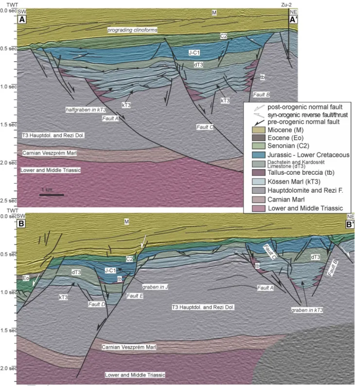
Seismic section in the western foreland of the Keszthely Hills
Two NE–SW-trending segments of 2D seismic sections are presented in this paper (Fig. 5a, b), which is situated in the northwestern foreland of the Keszthely Hills (Fig. 1b). The
Fig. 3 Pilikán quarry (L2). a Dolobreccia intercalation of the Upper Norian Rezi F. on the eastern wall; b closer view on dolobreccia; c late Tri- assic synsedimentary faults on the southern wall of the quarry. For legend of the stereonet, see Fig. 2d
337 338 339 340 341 342
343
344 345 346 347 348 349 350 351 352 353 354 355
356
357 358 359 360 361 362 363 364 365 366 367
368 369
370 371 372
UN CORRECTED PR
OOF
UN CORRECTED PR
OOF
sections run parallel to each other, and they add important new information to the pre-orogenic structures.
Seismic facies of the formations
The pre-Senonian basement is represented by characteristic features (Figs. 1d, 5a, b). The relatively strong reflection package between 1.6 and 2.2 s TWT depth is equivalent to the Carnian Veszprém Marl. It is characterized by low-to- high amplitude; reflectors laterally often fade away (Fig. 1d), which may represent interfingering with coeval platforms (Ederics Fm.). Veszprém Marl was drilled by the nearby Kd-3 well under 3.4 km of Upper Triassic dolomite. Above this formation, a significantly thick unit without any strong reflections occurs, which is interpreted as the Hauptdolomit and the Rezi Dolomite, which are considered as one seismic unit in this paper. This seismic unit is represented by very low-to-low amplitudes; occasionally, short, pale reflectors occur (Fig. 1d). The thickness of these two dolomite for- mations is around 1 s in time, which suggests more than 3 km thickness, applying the VSP data of Dohr (1981). The strong continuous reflections above this unit represent the Kössen Marl. The medium-to-high amplitudes are related to the significant impedance contrast between the marl and the limestone intercalations (Fig. 1d). However, the strong reflections first fade away and then disappear approaching the faults. The thin, non-reflective unit above the Kössen Marl may be correlated to the Upper Rhaetian prograding tongue of the Dachstein and Kardosrét Fm. Consequently, the strong reflections of the Kössen Marl are sandwiched between two, relatively monotonous platform carbonates without reflections. The Jurassic–Early Cretaceous succes- sion, which is made up by thin formations with variable lithologies, shows again relatively strong continuous reflec- tors on seismic sections, which can be characterized by low- to-high amplitude (Figs. 1d, 5a, b).
This Upper Triassic–Lower Cretaceous succession is unconformably overlain by Senonian shallow marine marl with limestone intercalations and platform limestone (Fig. 5a, b). The variable lithology of the Senonian marl causes again continuous reflectors with high amplitude (Fig. 5a), while the relatively monotonous platform lime- stone shows low-amplitude reflectors. On the section A–A′, the reflections of the Senonian marl onlap onto the basal surface of the Senonian (Fig. 5a). The Senonian deposits
are unconformably overlain by Miocene succession, which was deposited in a prograding delta system. The related clinoforms are well visible, and dip apparently towards SW (Fig. 5a, b).
Structural geometry
The most prominent structure of the section A–A′ is an extensional graben, which is sealed by the Senonian deposits (Fig. 5a). This graben can be traced on the northeastern part of the section B–B′, but it is much narrower there (Fig. 5b).
The graben has a segmented southwestern, NE-dipping boundary fault (Fault A) and a northeastern, SW-dipping boundary fault (Fault B). The graben is dissected by an addi- tional NE-dipping fault (Fault C) creating two sub-grabens.
These faults are post-dated by Senonian; however, Fault A and C show minor Senonian re-activation (Fig. 5a). On sec- tion B–B′, Fault C seems to be cut by a younger, probably Senonian fault (Fig. 5b). The Kössen Marl forms SW-ward thickening half-grabens above the gently SW-ward tilted blocks, which are pronounced on section A–A′ (Fig. 5a).
On the section B–B′, the graben shows more symmetric geometry (Fig. 5b). In the southwestern sub-graben, off- lap surface within the Kössen Marl occurs (Fig. 5a). The contact between the Dachstein Limestone and the Kössen Marl is also an off-lap surface. In the vicinity of the major faults, the seismic image of the Kössen Marl shows poor quality, and in the hanging wall of the faults, wedge-shaped bodies are outlined (Fig. 5a, b). We interpret these bodies as fault-bounded talus breccia. The thickening trends of the Kössen Marl suggest that Fault A and C were dominantly active during its deposition (Fig. 5a, b). The Dachstein and Kardosrét Limestone are gradually thickening towards Fault B, which is well illustrated in section B–B′ (Fig. 5b). Only minor offset of these formations can be observed along the other two faults (Fault A and C). Therefore, the fault activity retreated onto Fault B during the deposition of the Dachstein and Kardosrét Limestone. If we restore the Senonian re- activation of Fault A and C, it seems that Jurassic strata sealed these faults. However, Jurassic deposits occur only in the hanging wall of Fault B, which suggests that the fault was active during or after deposition, but before the deposi- tion of Senonian rocks.
On the southwestern part of the section B–B′, another pre-orogenic graben is enclosed by Fault D and Fault E (Fig. 5b). The Kössen, Dachstein, and Kardosrét Formations do not have any thickness changes related to these faults. On the other hand, Jurassic succession is thicker in the graben, and reflections in the Jurassic seals Fault D, that suggest Jurassic synsedimentary movement. Fault E is re-activated by post-orogenic extension probably during Senonian and Miocene; nevertheless, it shows significantly bigger pre- Senonian offset (Fig. 5b).
Fig. 4 a Tilted normal faults in the eastern Gyenesdiás quarry (L3), observed in Rezi Dolomite. b Stereonet data before tilt test. c Stere- onet of data after tilt test. d Gyenesdiás, western quarry (L4). Late Triassic synsedimentary normal fault or slide in the laminated to thin-layered Rezi Dolomite. f Measured fault-slip data g Late Trias- sic synsedimentary structures in the Felsőhegy quarry (L5), observed in Hauptdolomit. h Measured fault-slip data. Legend for stereonet:
Fig. 2d
◂
AQ5 373 374
375
376 377 378 379 380 381 382 383 384 385 386 387 388 389 390 391 392 393 394 395 396 397 398 399 400 401 402 403 404 405 406 407 408 409 410 411 412 413 414 415
416 417 418 419
420
421 422 423 424 425 426 427 428 429 430 431 432 433 434 435 436 437 438 439 440 441 442 443 444 445 446 447 448 449 450 451 452 453 454 455 456 457 458 459 460 461 462 463 464 465 466
UN CORRECTED PR
OOF
Small normal faults are visible on the horst between Fault E and Fault A. These faults cross cut only the Dachstein and Kardosrét Limestone, and they probably detach on the Kössen Marl. These structures possibly rep- resent mega-slides (Fig. 5b).
The sections are situated in the core of the “mid”-Cre- taceous Sümeg-Devecser syncline (Tari 1994), and they are subparallel to the axis of syncline. Therefore, no major
“mid”-Cretaceous contractional structures are visible on these sections. However, minor thrusts and related faults
Fig. 5 a A–A′ and b B–B′ interpreted 2D seismic sections in the NW foreland of Keszthely Hills. Approximate location of the section is indi- cated in Figs. 1b and 6a. Blank version of the sections is visible in Supplementary Appendix I
467 468 469 470 471
472 473 474 475 476
UN CORRECTED PR
OOF
occur in the pre-Senonian rocks (Fig. 5a). It is interesting that these structures are localized by the early pre-orogenic faults. In the case of Fault A and B, antithetic small thrusts developed in the proximal hanging wall of the faults within the Jurassic succession. Above/near the Fault C on top of a small horst small double verging thrusts developed in the Kössen Marl, which made a gentle anticline in the Dachstein Limestone. These compressional structures formed due to moderate Cretaceous shortening.
The above-described extensional faults can be traced on other seismic sections, as well. On the bases of these 2D seismic lines, the strike of these structures is between WNW–ESE and NW–SE.
Interpretation of field observations
Coarse breccias along the Late Triassic Cserszegtomaj FaultMap-view synsedimentary normal faults can be often out- lined based on facies distribution and the presence of coarse
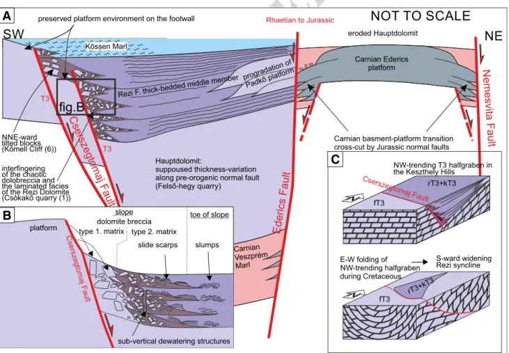
breccias in the proximal hanging wall of the fault (e.g., Ber- totti et al. 1993). Dolomite breccias of the Rezi Dolomite described in the outcrops of the Keszthely Hills have dolo- mite matrix, which suggests that these are sedimentary brec- cias. These breccias re-deposited on a most probably fault- controlled slope (Csillag et al. 1995). Such breccias could be alternatively formed after deposition, due to seismic shock of semi-unconsolidated mud (Hips et al. 2016). In the study area, dolomite breccia outcrops of the Rezi Formation are limited to an NW–SE-trending belt along the southwestern edge of the Keszthely Hills (Fig. 6c). Coarse breccias of the Csókakő quarry (L1) and the Kőmell cliff (L6) could be interpreted as proximal talus breccia (Fig. 2a), while the more fine-grained breccia intercalation in the Pilikán quarry (L2) could be interpreted as a more distal lobe of fault-related mass movements (Fig. 3b). Platform environ- ment is suggested as the source of fossil-rich blocks in the Csókakő quarry (L1) (Csillag et al. 1995).
South of the dolomite breccia occurrence of Csókakő quarry (L1) Hauptdolomit is exposed (Figs. 6a, 7a). The WNW–ESE-trending contact of the two formations was identified already by former mapping (Bohn 1979; Budai
Kössen Marl
Rezi F. thick-bedded middle member
NNE-ward tilted blocks (Kőmell Cliff(6)) interfingering of the chaotic dolobreccia and the laminated facies of the Rezi Dolomite (Csókakő quarry (1))
progradation of Padkőplatform
Hauptdolomit:
suppoused thickness-variation along pre-orogenic normal fault (Felső-hegy quarry)
eroded Hauptdolomit
Carnian Ederics platform
Carnian Veszprém Marl
Carnian basment-platform transition cross-cut by Jurassic normal faults
SW NE
T3 T3
Rhaetian to Jurassic
NOT TO SCALE
preserved platform environment on the footwall
A
Cserszegtomaj Fault
Ederics Fault
Nemesvit
aFaul
t
slope toe of slope
sub-vertical dewatering structures Cserszegtomaj Fault
platform type 1. matrix type 2. matrix
slumps slide scarps
dolomite breccia
B
fig.B
Cserszegtomaj Fault
NW-trending T3 halfgraben in the Keszthely Hills
E-W folding of NW-trending halfgraben during Cretaceous
S-ward widening Rezi syncline rT3+kT3
rT3+kT3 fT3
N fT3
N
C
Fig. 6 a Pre-Miocene geologic map of the Keszthely Hills, and its NW foreland. b Detailed map of the Eastern Keszthely Hills. c Late Triassic synsedimentary structures along the Cserszegtomaj Fault
477 478 479 480 481 482 483 484 485 486 487 488 489
490
491 492
493 494
495 496 497 498 499 500 501 502 503 504 505 506 507 508 509 510 511 512 513 514 515 516
UN CORRECTED PR
OOF
UN CORRECTED PR
OOF
et al. 1999b); however, it was interpreted as a stratigraphic contact (Fig. 1b). In our interpretation, this contact repre- sents a Late Triassic synsedimentary normal fault, which is referred as the Cserszegtomaj Fault in this paper (Fig. 6a).
Probably, the southern WNW-trending border of the Rezi Dolomite occurrences near Gyenesdiás represents further NNE-dipping segments of Cserszegtomaj Fault, which was connected by ESE-dipping relay ramps (Fig. 6a, c).
Progradational tounge of dolomitized platform carbonates above the Rezi Dolomite was documented in the eastern part of the Keszthely Hills by Csillag et al. (1995). This pat- tern suggests rather asymmetric half-graben geometry for the Late Norian basin of the Keszthely Hill (Fig. 7a). Note that the southward widening geometry of the N-trending Rezi syncline could be also explained by the Cretaceous folding of a WNW–ESE-trending Late Triassic half-graben (Fig. 7c).
The Cserszegtomaj Fault can be correlated with Fault A and C introduced on seismic sections. The activity of these NE–NNE-dipping faults is evidenced by main syntectonik deposits, which is represented by Rezi Dolomite in the Kes- zthely Hills (Fig. 7a, b), and Kössen Marl on the seismic section (Fig. 5a, b). Probably, all of these faults were active simultaneously, although the resolution of seismic sections does not allow the observation of synsedimentary deforma- tion of the Rezi Dolomite. The lack of Kössen Marl outcrop in the Keszthely Hills made it problematic to observe its deformation. Nevertheless, the presence of slumps and sedi- mentary breccias in the Kössen Marl was documented based on wells in the Keszthely Hills (Haas 1993).
Rhaetian? To Jurassic extensional horst of the eastern Keszthely Hills
Reinterpretation of former geologic map (Budai et al. 1999b) suggests the presence of further map-view pre-orogenic structure in the Eastern Keszthely Hills. The easternmost part of the Keszthely Hills (Fig. 1b) is built up by Carnian formations (Csillag et al. 1995; Budai et al. 1999b). These formations partly dolomitized platform carbonates (Ederics Fm.) intercalating with the basinal Veszprém Marl (Csil- lag et al. 1995; Budai et al. 1999b; Haas et al. 2014). The Carnian formations have tectonic contact with the Rezi Dolomite and the Hauptdolomit. The fault system bound- ing Carnian formations has a northern WNW–ESE-trending segment (Nemesvita Fault), a western N–S trending seg- ment (Szent Miklós Fault), and a southern NW–SE-trending
segment (Ederics Fault) (Fig. 6a, b). The whole area is dominated by western dips, which formed during the “mid- Cretaceous” E–W shortening. There are areas (e.g., along the Szent Miklós Fault), where the Carnian Veszprém Marl is in direct contact with the Upper Norian Rezi F., and thus, the whole Hauptdolomit, which is more than 1 km thick, is tectonically omitted.
The Szent Miklós Fault is sub-vertical based on the verti- cal electric sounding of Gulyás (1991). That is why, it was interpreted by Dudko (1996) as a syn-orogenic, syn-folding strike–slip fault. In our interpretation, the large (km-scale) vertical displacement can be explained rather by normal or oblique-slip faulting (Fig. 6a, b). The actual sub-vertical dip of the fault (Gulyás 1991) can be the result of later, moder- ate tilting, associated with syn-orogenic Cretaceous fold- ing, which steepened, but not overturned the original west- dipping fault.
It is clear from map view that the Szent Miklós Fault is dissected by NW–SE-trending sinistral faults with few 100 m of offset (Fig. 6a, b) (Budai et al. 1999b; Dudko 1996). These sinistral faults can be considered as syn-folding tear faults, since they have significant offset on the eastern
“mid-Cretaceous” syncline (Vállus syncline); on the other hand, they die out towards northwest, and do not crosscut the western syncline (Rezi syncline). These sinistral faults were probably re-activated during the Late-Oligocene–Early Miocene, when a very similar stress field was present (Fodor et al. 1999). These sinistral faults also prove that the Szent Miklós Fault is an older, pre-orogenic fault, which was over- printed by the structures of Cretaceous compression. On the other hand, no coarse breccia was observed along the Szent Miklós Fault, which may suggest that it is younger than Rezi Dolomite.
Although there are no data on the age of Nemesvita and Ederics Fault, we suggest that these faults are coeval with the Szent Miklós Fault, and they represent a pre-orogenic extensional horst. The Ederics Fault shows many similari- ties to Fault B, which is slightly younger than Fault A and C.
Fault B was moderately active during the deposition of Kös- sen Marl, but it was still active later, during the deposition of Dachstein and Kardosrét Limestone when the southwestern boundary faults (Fault A and C) were inactive (Fig. 5a). The presence of Jurassic deposits in the hanging wall and the Senonian seal suggests that Fault B was slightly active dur- ing the Jurassic, too. The same situation is suggested for the pre-orogenic horst of the eastern Keszthely Hills (Fig. 7a).
Pattern of outcrop‑scale pre‑orogenic normal faults Many of the described faults in the Keszthely Hills can be interpreted as synsedimentary Late Triassic structures, based on several features. Such features are thickness variations of the beds along faults (Fig. 3c, 4d, e, g), the presence of
Fig. 7 a Model cross section across the Keszthely Hills, showing the pre-orogenic basin geometry. b Position of the Csókakő quarry in relationship with Cserszegtomaj fault. c Simplified cartoon explain- ing the formation of the southward widening Rezi syncline, as a folded Late Triassic half-graben
◂
517 518 519 520 521 522 523 524 525 526 527 528 529 530 531 532 533 534 535 536 537 538 539 540 541 542 543 544 545 546
547 548
549 550 551 552 553 554 555 556 557 558 559 560 561
562 563 564 565 566 567 568 569 570 571 572 573 574 575 576 577 578 579 580 581 582 583 584 585 586 587 588 589 590 591 592 593 594 595 596 597 598 599 600 601 602 603 604 605 606 607
608
609 610 611 612
UN CORRECTED PR
OOF
wedge-shaped syntectonic beds (Fig. 4d, e), or faults sealed by younger beds of Late Triassic succession (Fig. 3a, c). In the Pilikán quarry (L2), small synsedimentary reverse faults occur besides normal faults. Certainly, all of these faults formed in the same extensional stress field, and the reverse faults formed due to space problems related to the movement along a non-planar normal fault plane.
Small steps of the beds in the western Gyenesdiás quarry (L4) (Fig. 4e) can be interpreted as healed normal faults, where the discrete faults disappeared due to diagenetic pro- cesses. These structures can be considered as pre-diagenetic faults. Tilted normal faults of the eastern Gyenesdiás quarry (L3) represent structures which are postdate deposition and diagenesis; on the other hand, they developed before tilting/
folding, which age is Early Albian based on projection of structural data from the central Transdanubian Range (Fodor et al. 2017).
The strike of outcrop-scale synsedimentary normal faults is in accordance with map-scale pattern (Fig. 6a), since most of these structures shows NNE–SSW or NE–SW extension (Figs. 3d, 4c, h,). This direction of extension is in accord- ance with the trend of other pre-orogenic normal faults, described in the central and northeastern Transdanubian Range. The ages of such structures are Middle Triassic (Budai and Vörös 2006) or Early and Middle Jurassic (Vörös and Galácz 1998; Lantos 1997; Fodor 2008). Perpendicular, WNW–ESE extension (Fig. 4f) was estimated based on the fault/slide of the western Gyenesdiás quarry (L4), which is situated most probably on a relay ramp which connects two segments of the Cserszegtomaj Faults (Fig. 6a).
Pattern of slumps and slides
The presence of slumps and slides is widespread in the laminated Rezi Dolomite. In the Csókakő quarry (L1), an extensional and a compressional domain can be separated, similar to many case studies (e.g., Farrell 1984; Debacker et al. 2009; Alsop and Marco 2011). We suggest that the NNE-ward-dipping beds of the southern part of the quarry represent the original dip of the slope (see next chapter).
Slide scarps are present mostly in this part of the quarry (extensional domain). The northern side of the quarry, which can be characterized by horizontal dips, is dominated mostly by slumps. This part of the quarry situated on the toe of the slope where compressional domain developed.
The strike of slide scarps and slump-fold axes may allow to determine the sedimentary transport direction. The strikes of slide scarps are theoretically parallel to the strike of the slope. On the other hand, slump-fold axes can suffer nota- ble rotation, after a significant transport (Alsop and Marco 2011). During the early stage of slump formation, the slump fold shows symmetric geometry. In that stage, the axis of the slump is perpendicular to the dip direction of the slope
(Bradley and Hanson 1998). Slumps observed in Rezi Dolo- mite show symmetric or slightly asymmetric geometry suggesting minor transport (e.g., Fig. 2b). Therefore, the transport direction is supposed to be sub-perpendicular to the fold axis. While most of the observed slump axes are NW–SE directed (Fig. 6c), the gravity slide transport direc- tion is toward NE in the hanging wall of the fault segments [Csókakő quarry (L1), Kőmell Cliff (L6)] (Fig. 6c). On the other hand, the slump-fold axes pronouncedly different on relay ramps (NE-trending) which may suggest SE-ward mass transport [Budai Hill quarry (L7), Gyenesdiás quarries (L3) and (L4)] (Fig. 6c).
Slump folds often show features resembling metamorphic ductile structures; for example, the presence of stretching lineation is common in the case of soft-sediment deforma- tion (Ortner 2013). However, in our case, a completely dif- ferent type of lineation was observed. On the polished sur- face of samples, it is visible that this lineation derives from fold hinges of microfolds (Fig. 2b, c).
Dewatering structures
An episode of talus-cone breccia formation probably pro- vided considerable volume of sediments. The sudden load made the underlying unconsolidated thin-layered carbonate mud compacted, and de-watered. The chaotic zone of the Csókakő quarry (L1) may indicate dewatering and fluidisa- tion of originally laminated sediments, similar to examples of Ortner (2007). Sediment fluidization occurred where the original sedimentary features of the laminated dolomite were completely destroyed (Knipe 1986; Ortner 2007). The dewatering related compaction could be responsible for the collapse and subsidence (down bending) of overlying beds (upper laminated layer). The vertically arranged few cm zones can be interpreted as dewatering pipes, where water was released from a deeper beds (Fig. 2a). The tilted beds of the Csókakő quarry (L1) are dissected by sub-vertical dewatering pipes and fluidized zone (Figs. 2a, 7b). It con- firms that the tilting in the Csókakő quarry (L1) pre-dates diagenetic processes, such as dewatering, and the tilted strata there represent the original dip of the tectonically controlled slope.
The style of the above-mentioned early deformation was probably highly influenced by the early diagenetic process such as dolomitization (Meister et al. 2013). Platform-orig- inated re-deposited blocks observed in the Csókakő quarry (L1) (Fig. 2a) probably underwent early dolomitization, as well (Haas et al. 2012), which redound the “brittle” re-dep- osition, represented by blocks. On the other hand, the lami- nated Rezi Dolomite—which deposited in deeper marine environment—probably dolomitized later, during burial;
therefore, dolomitization did not obstruct soft-sediment deformation, such as slumping or soft-sediment fluidization.
613 614 615 616 617 618 619 620 621 622 623 624 625 626 627 628 629 630 631 632 633 634 635 636 637 638 639 640 641 642
643
644 645 646 647 648 649 650 651 652 653 654 655 656 657 658 659 660 661 662 663
664 665 666 667 668 669 670 671 672 673 674 675 676 677 678 679 680 681 682
683
684 685 686 687 688 689 690 691 692 693 694 695 696 697 698 699 700 701 702 703 704 705 706 707 708 709 710 711 712 713 714