Celestial Coordinate Systems
1 HE geometric coordinate system which is of primary importance in actual observation is the system based on the local astronomical horizon as the fundamental reference circle; it is a means of representing the local aspect of the sky, and it is a necessary intermediary in establishing and utilizing the coordinate systems on the rotating celestial sphere. For the systematic representation of the immediately observed aspects of the celestial sphere in exact geometric terms, it is practically the only feasible reference system. In the earliest times it was the most natural means for this purpose because, among all the circles of the sphere, the horizon is the only one that is even approximately delineated visibly on the sky in nature; and this system continues to be indispensable in practice since the vertical, concretely represented by the plumb line, and the horizontal defined by the level, are the only reference directions in the geometric coordinate systems that are immediately accessible to direct observation. The other cardinal directions and reference circles can be located only by more or less extended observa- tions of the stars and other celestial objects; both in tracing the fundamental reference circles among the standard stars, and in the practical measurement of positions relative to these stars by means of which they are referred to the coordinate systems on the rotating celestial sphere, the local horizon system is an essential intermediary.
In the instruments used for astrometric measurements, the essential element is a sighting device equipped with graduated circles that concretely represent reference circles of the celestial sphere. The primary operation consists of sighting on convenient observable reference points to determine fiducial points on the graduated circles, then sighting on celestial bodies to determine their angular distances from these immediate reference points.
The relation of the immediate reference directions, which the fiducial points of the circles concretely represent, to the cardinal directions in the astronomi- cal coordinate systems enables the coordinates of objects to be found from the directly measured angles ; but the determination of this relation depends, directly or indirectly, upon referring the fiducial directions to the horizon reference system defined by the local astronomical vertical which can be visibly marked by the plumb line.
14
The Local Horizon Coordinate System
The line where the surface of the Earth is seen projected against the celestial sphere is the visible horizon or apparent horizon. It is in general irregular;
but at sea or on a level plain it is practically a circle on the sphere, determined by lines of sight tangent to the surface of the Earth, although it is not a great circle if the observer is at an appreciable elevation above the surface, because the lines of sight form a cone which intersects the sphere in a small circle.
The astronomical horizon, to which the apparent horizon is a more or less close approximation, is the great circle in which the celestial sphere is intersected by the plane that passes through the observer and is perpendicular to the direction of local gravity. This great circle is the fundamental circle of the horizon system of coordinates. The primary direction is that of the plumb line, determined by gravity, and is called the astronomical vertical', it is not necessarily, nor even usually, exactly perpendicular to the physical surface of the Earth, even in "level" regions, but is very nearly so in topo- graphically flat regions, and is always perpendicular to the surface of a fluid at rest.
Any plane that is perpendicular to the astronomical vertical is a horizontal plane. The astronomical horizon is the great circle in which the horizontal plane through the observer intersects the celestial sphere; a distinction is sometimes made between this circle, known as the sensible horizon, and the intersection of the celestial sphere with a horizontal plane through the center of the Earth, known as the rational horizon. However, all planes perpendicular to the vertical and at finite distances apart intersect the sphere in the same great circle, since these planes are parallel, and the distinction serves no useful purpose. The horizon is often defined by means of a plane tangent to the surface of the Earth ; but this definition is not satisfactory, because obviously the actual physical surface cannot be adopted for the purpose.
This method of definition therefore depends upon the selection of some particular hypothetical surface to represent the form of the Earth.
The geometric poles of the fundamental circle are known as the zenith and the nadir. The true or astronomical zenith is the point vertically upward or overhead, i.e., the point where a plumb line, produced indefinitely upward, would intersect the celestial sphere; the nadir is the point diametrically opposite the zenith.
The secondary circles to the horizon are the great circles through its poles, i.e., through the zenith and the nadir, and therefore necessarily perpendicular to the horizon. They are known as vertical circles; the planes of these circles are vertical planes, and all intersect in the astronomical
vertical. The small circles parallel to the fundamental circle, i.e., to the horizon, are called parallels of altitude, or sometimes almucantars (also spelled almucantur).
The particular vertical circle that passes through the elevated celestial pole is the celestial meridian; since it is a great circle, it necessarily passes through both celestial poles, and as it is a vertical circle it passes through the zenith and the nadir, and is perpendicular to the horizon. The vertical circle at right angles to the meridian is the prime vertical.
The intersection of the plane of the meridian with the plane of the horizon is the meridian line. The points at which the meridian and the prime vertical intersect the horizon are the cardinal points of the horizon—north and south, east and west. The east point is the intersection of the prime vertical with the arc of the horizon where the celestial bodies rise; the opposite inter- section, on the arc of the horizon where the celestial bodies set, is the west point. North is the direction 90° to the left of east; the elevated pole is in either the north or the south, depending upon location on the surface of the Earth. The north and south points are the poles of the prime vertical; the east and west points, the poles of the meridian.
The celestial meridian and the astronomical horizon are adopted as the principal reference circles, and one of the cardinal points of the horizon as a zero point of reference on this circle. Relative to this system of reference, the position of any point on the celestial sphere is represented by its altitude (or, alternatively, its zenith distance) and its azimuth.
The altitude H is the angular distance from the astronomical horizon, measured along the vertical circle that passes through the given point, and reckoned positive above the horizon, negative below. It is represented either by the angle at the observer between the lines of sight to the point and to the foot of the vertical circle on the horizon or by the arc of the vertical circle intercepted between these lines of sight. The zenith distance z is the angular distance from the zenith, measured along the vertical circle; it is the complement of the altitude and varies from 0° at the zenith to 90° at the hori- zon and 180° at the nadir. Algebraically, z = 90° - H. When z > 90°, the angular distance below the horizon is often called the depression; its value is z — 90° = — H. For example, a depression of 10° is an altitude of —10° or a zenith distance of 100°.
The azimuth A is the arc of the horizon intercepted between the adopted zero point of the horizon and the foot of the vertical circle through the given point. It is the angle at the zenith between the vertical circles through the zero point and the given point, or the dihedral angle between the planes of these two vertical circles. Azimuth is reckoned in a variety of different ways in practice, but usually from either the north or the south point, and either both eastward and westward from 0° to 180° or else continuously eastward
or westward up to 360°. To prevent uncertainty, the method of reckoning should always be stated. In navigational terminology, the directions of terrestrial objects are commonly expressed by the true bearing, which is the azimuth reckoned from the north point, continuously eastward from 0°
to 360°.
The direction of a point that is on the horizon is frequently referred to the east or the west point, whichever is the nearer, instead of to the north point or south point. The angular distance in azimuth from east or west at the horizon is the amplitude.
The Coordinate Systems on the Rotating Celestial Sphere
From the viewpoint of the observer, the circles of the horizon system are fixed in the sky, they do not participate in the apparent diurnal motion but remain stationary while the celestial sphere rotates past them. For geometrically representing positions on the rotating sphere, independently of its continually changing local aspect relative to the fixed circles of the horizon system, a coordinate system fixed on the sphere and rotating with it is required.
In practice, coordinate systems based on the celestial equator and on the ecliptic are both used for this purpose; in observational astronomy, the equatorial system is the principal reference system, but in theoretical astron- omy the ecliptic system is more advantageous for many purposes.
The Equator System
The fundamental circle of this system is the celestial equator, determined by the axial rotation of the Earth. The equator, also known as the equi- noctial, is the great circle of which the celestial poles are the geometric poles;
its plane is perpendicular to the axis of apparent rotation of the celestial sphere, and it is everywhere 90° from both celestial poles.
The equator intersects the ecliptic in two points 180° ^part, since the ecliptic and the equator both are great circles. These intersections are the equinoctial points or equinoxes; the points on the ecliptic that are 90° from the equinoxes are the solstitial points or solstices. The equinox at which the Sun, in its apparent annual motion, crosses from south,of the equator to north has been traditionally called the vernal equinox, and the opposite point the autumnal equinox, because the times when the Sun reaches these points are the beginnings of astronomical spring and astronomical autumn in the northern hemisphere of the Earth; but since these terms are not literally applicable in the southern hemisphere, the two equinoxes are preferably distinguished as the March equinox and the September equinox.
An alternative term for the vernal equinox is the First Point of Aries, because the zodiacal sign of Aries begins at this point; when there is no risk of ambiguity, the word equinox alone is often used.
The secondary circles of the equator system are the great circles through the celestial poles. The secondary that passes through the equinoxes is called the equinoctial colure, and the secondary through the solstices is the solstitial colure; the equinoxes are the poles of the solstitial colure. The colures have been improperly defined by a few writers in the past as passing through the poles of the ecliptic instead of through the celestial poles. The two colures are perpendicular to each other.
The equator and the equinoctial colure are the principal reference circles of the system of equatorial coordinates; and the First Point of Aries is the zero point of reference. The angular distance of any point of the celestial sphere from the equator, measured on the secondary through the point, and reckoned positive northward from the equator, negative southward, is the declination of the point. The arc of the equator intercepted between the First Point of Aries and the secondary through the given point, reckoned eastward from this equinox continuously around the sphere, is the right ascension; equivalently, it is the angle at the celestial poles between the equinoctial colure and the secondary through the point.
Instead of declination, the polar distance reckoned from 0° to 180° is some- times used as one coordinate; algebraically, north polar distance is equal to 90° — <5, south polar distance is 90° + <5, where ô denotes the declination.
Also, in some astronomical calculations, particularly in celestial navigation, it is convenient to use the angular distance reckoned westward along the equator from the First Point of Aries as a coordinate (i.e., 360° — a, instead of the right ascension a directly); this measure was formerly called the versed ascension, but after its general adoption in the national air navigation almanacs soon after they first began to be regularly issued, and later in the almanacs for marine navigation also, the term sidereal hour angle became the generally established name.
From the definitions of the fundamental reference circles of the equator system, and the conception of the celestial sphere as mathematically infinite, it is evident that this coordinate system cannot depend upon the geographical position of the observer; and since it participates in the diurnal rotation of the celestial sphere, the coordinates do not depend upon the stage that has been reached in the diurnal circuit. Therefore, the identification of points on the sphere by their equatorial coordinates is a means of representing the apparent positions of the celestial bodies on the moving sphere inde- pendently of the local aspects relative to the horizon at any particular time or place.
However, the reference circles of the equator system are not absolutely
fixed in position on the celestial sphere. It was discovered from observations in ancient times that the celestial poles and equator are slowly moving among the stars, causing a progressive westward motion of the equinoxes along the ecliptic that is known as the precession of the equinoxes; and the more accurate observations in later times detected a further small periodic oscilla- tory motion superimposed upon the precession, which was given the name of nutation. Since the positions of the poles and equator on the celestial sphere are determined by the rotation of the Earth, these motions must necessarily be ascribed to a variation of the direction of the axis of rotation in space, although on the ancient hypothesis of a motionless Earth the precession was equally well represented by a motion of the supposed sphere on which the stars were fixed. The motion of the axis of rotation in space is due to the disturbing gravitational attractions of the Sun and the Moon on the rotating Earth. As the reference circles move over the sphere, the equatorial coordinates of any fixed point of the sphere slowly change; and in any comparison for different times which are far enough apart for the displacement of the circles during the interval to have become appreciable, this change must be recognized.
Hour Angle and the Empirical Measures of Time
The celestial equator intersects the horizon at the east and west points, since these points are the poles of the meridian and are therefore the points of the horizon that are 90° from the celestial pole. The equator is inclined to the horizon at a fixed angle which depends upon the geographic location and is equal to the complement of the altitude of the celestial pole ; one semicircle of the equator is always above the horizon, the other semicircle below, excluding the exceptional case in which the celestial pole is at the zenith and the equator coincides with the horizon.
The equator and the small circles parallel to it coincide with the diurnal circles. The position of a celestial body in its diurnal circuit at any instant is conveniently measured by the angle at the celestial pole between the meridian and the secondary to the equator that passes through the body.
This angle, or equivalently the arc of the equator intercepted between the meridian and the secondary, is called the hour angle because of its relation to the measurement of time by means of the diurnal motions. The hour angle is reckoned positively westward, i.e., in the direction of the apparent diurnal motion, from the intersection of the meridian with the semicircle of the equator that is above the horizon. The motion of a celestial body in hour angle during each successive circuit measures its progress from meridian passage to the next meridian passage, and is a means of reckoning the passage of time by the diurnal motion. The motion depends upon both
the diurnal rotation of the celestial sphere and the individual motion, if any, of the body on the rotating sphere. The value of the hour angle at any instant is a measure of the interval of time elapsed since meridian passage, in units of the interval required for one complete circuit.
Accordingly, for the purpose of measuring hour angles, the equator is divided into 24 arcs of 15° each, beginning at the meridian, which are conventionally called hours and are used instead of degrees as the units of angular measure; and hour angles ordinarily are expressed, not in arc measure, but in time measure reckoned from 0h to 24n westward from the meridian, by means of the equivalents 1° = 4m, lh = 15°. During each complete diurnal circuit, a celestial body moves through 24h in hour angle.
Although measured in units which are denoted by the same terms used to designate units of time, the hour angle is actually a geometric angle repre- senting position relative to the meridian in the diurnal circuit; but its value expressed in these terms is also a convenient measure of the length of time from meridian passage to the instant at which this position is reached.
However, as a measure of position, the unit of lh is uniformly an angle of 15° for all celestial objects; while as a measure of time, the unit of lh is the interval of time required for a motion of 15° in angular position, and the duration of this interval depends upon whatever individual motion the object may have on the rotating celestial sphere.
Because of this method of measuring the angles between the meridian and the secondary circles of the equator system, the secondaries to the equator are usually referred to as hour circles; and right ascension, like hour angle, is almost invariably expressed in time instead of in arc. However, right ascension is measured eastward from the First Point of Aries and is not altered by the diurnal rotation of the celestial sphere, while hour angle is reckoned westward from the meridian and depends upon the diurnal motion.
Hour angle and declination constitute a separate system of coordinates from right ascension and declination, and are partially dependent on geographic location. Strictly speaking, two distinct families of great circles through the celestial poles should be recognized, one family fixed relative to the meridian and stationary in the sky, the other fixed on the celestial sphere and rotating with the diurnal motion. The circles which are fixed in the sky and indicate hour angles are the ones to which the name hour circles most logically applies, while the circles that are fixed on the rotating sphere are more properly called circles of declination; however, this distinction is not in general now maintained, and the term circle of declination is not commonly used. The small circles parallel to the equator are called parallels of declination.
The hour angle h of any celestial object is always h = T — a,
where a is its right ascension and τ is the hour angle of the First Point of Aries. At the instant when an object at right ascension a is on the meridian, where h = 0, the First Point of Aries is at the hour angle τ = α. West azimuths correspond to hour angles from 0h to + 12h, east azimuths to hour angles from +12h to +24h, or alternatively from 0h to — 12h. The hour angle of the west point of the horizon is +6h, and the hour angle of the east point is +18h or equivalently — 6h.
The measure of time which is defined by the motion of the Sun in hour angle, and is shown by an accurate sundial, is called apparent solar time.
It was formerly the time commonly used for the purposes of ordinary daily life; but for the purpose of the precise timekeeping that is now necessary, the measurement of time directly by the actual diurnal motion of the Sun is impracticable because of the rather large and complex variations in the rate of motion in hour angle which occur during the course of the year due to the inequalities in the annual motion of the Sun along the ecliptic and to the inclination of the ecliptic to the equator. However, a measure conforming to the average motion of the Sun in hour angle is a satisfactory practical alternative; accordingly, a conventional mean sun is introduced for this purpose. The mean sun is defined as a point on the celestial equator, with a uniform annual motion along the equator at a rate virtually the same as the mean rate of the annual motion of the Sun along the ecliptic. This point has a diurnal motion in hour angle virtually the same as the average diurnal motion of the Sun, and a position in hour angle alternately behind and ahead of the Sun but never by amounts greater than about 16m; time measured by its diurnal motion is called mean solar time.
Since this abstractly defined point is not an actual visible object, mean solar time is not directly observable. In practice, it is defined by its relation to the measure of time obtained from observations of the diurnal motions of the stars and is determined by calculating it from this relation. The time obtained from the stars is called sidereal time and is the measure defined by the apparent diurnal motion of the First Point of Aries. Sidereal time differs from mean solar time because the Sun is continually moving relative to the stars and consequently has a different motion in hour angle, but-the relation of the average diurnal motion of the Sun to the diurnal motions of the stars may be derived from the known apparent annual motion of the Sun. The mean sun is defined by an adopted formula for its right ascension, which fixes its position among the stars and determines the relation of mean solar time to sidereal time that constitutes the exact definition of mean solar time, as explained in later chapters.
The numerical measure of sidereal time at any instant is the hour angle of the First Point of Aries; it is reckoned from 0h at the instant of meridian transit, up to 24h at the next meridian passage. Since at every moment the
hour angle τ of the First Point of Aries is equal to the right ascension of the meridian, the sidereal time may be determined from the right ascensions of the stars that are observed to be on the meridian at the instant; and from this the numerical measure of the mean solar time at this instant may be calculated.
The Ecliptic System
The fundamental plane of this system, the plane of the ecliptic, is deter- mined by the orbital motion of the Earth around the Sun. At every instant, the plane through the radius vector and the velocity vector of the Earth intersects the celestial sphere in a great circle along which the Sun, if viewed from the center of the Earth, would appear to be moving at that instant;
but the position of this plane in space is continually varying, because of irregularities produced in the motion of the Earth by the gravitational attractions of the other planets and the Moon. The variation, during which the instantaneous orbital plane always passes through the center of the Sun, may be represented as a very slow steady progressive, or secular, motion upon which are superimposed a large number of small periodic variations with different periods and amplitudes. At any instant, the position into which the secular component alone would have brought the plane is the instantaneous mean orbital plane, and the moving great circle in which this mean plane intersects the celestial sphere is the ecliptic. Since the plane of the instantaneous orbital motion oscillates irregularly about the mean plane, the Earth is not in general located in the mean plane, and the Sun is not exactly on the ecliptic; but the departures are small, and the ecliptic closely approximates the apparent annual path of the Sun among the stars as it would appear from the center of the Earth. Only with the accurate instru- ments of modern times could the difference between the ecliptic and the apparent annual path of the Sun, even as seen from the surface of the Earth, be detected by observation.
The ecliptic is the fundamental circle of the ecliptic system of celestial coordinates. The angle between the ecliptic and the equator is called the obliquity of the ecliptic e. The poles of the ecliptic are on the solstitial colure, with the north pole of the ecliptic at right ascension 18h near Omega Draconis, declination 90° — e.
The secondary circles to the ecliptic are the great circles passing through its poles, and are called circles of latitude. The small circles parallel to the ecliptic are known as parallels of latitude.
The coordinates of a point on the celestial sphere in this system are termed celestial latitude and celestial longitude. Celestial latitude is the angular distance from the ecliptic, reckoned along the secondary to the ecliptic that
passes through the point, positive to the northward and negative to the southward; the complement of the celestial latitude is the ecliptic polar distance. Celestial longitude is measured along the ecliptic from the equinox at the First Point of Aries, and is the arc of the ecliptic intercepted between the equinox and the circle of latitude through the point, reckoned eastward up to 360°.
Coordinates relative to the ecliptic, like equatorial coordinates, give the position on the celestial sphere itself, independently of the position of the rotating sphere relative to the horizon. However, the ecliptic coordinates of a fixed point of the sphere are slightly different at different times, both because of the motion of the ecliptic on the sphere due to the secular variation of the position of the orbital plane of the Earth in space, and because of the displacement of the equinox due to the motion of the equator on the sphere. The further displacement of the equinox by the motion of the ecliptic also causes a variation of the equatorial coordinates in addition to the change produced by the motion of the equator.
The obliquity of the ecliptic is equal to the dihedral angle between the planes of the ecliptic and the equator. The length of the great circle arc between the north poles of the ecliptic and equator, or between their south poles, is equal to the obliquity.
The equinoxes are the two points at longitudes 0°, 180°, and latitude 0°;
the solstices are the points at longitude 90°, latitude + e , and longitude 270°, latitude — e, at the greatest angular distances from the equator. The solstice north of the equator has traditionally been known as the summer solstice, and the other one as the winter solstice, because the times at which the Sun reaches these points are the beginnings of astronomical summer and winter in the northern hemisphere of the Earth; but these terms, like vernal equinox and autumnal equinox, are inappropriate in the southern hemisphere. All four terms are used in the double sense of points on the ecliptic and the times at which the Sun reaches these points during its annual circuit of the ecliptic.
The north celestial pole is at longitude 90°, the south pole at longitude 270°.
Beginning in ancient times, the band of the celestial sphere on either side of the ecliptic wLhin which the Sun, Moon, and planets move among the stars has been known as the zodiac, and has been subdivided into equal parts, usually 12 in number, called the signs of the zodiac. In the zodiac that has been transmitted from ancient Greek astronomy, the first sign, beginning at longitude 0°, is known as the sign of Aries; this is the reason why the equinox at this point is designated the First Point of Aries. Each of the 12 successive signs extends through 30° of longitude; and until late in modern times, position in longitude was commonly expressed in terms of
these signs, being reckoned from 0° to 30° within each sign instead of con- tinuously around the ecliptic from the equinox.
The zodiac is now considered to extend 8° in latitude on each side of the ecliptic, but various other widths have been used at different periods of history. The signs are named after constellations with which presumably they originally coincided ; but because of precession, the signs, which are invariably reckoned from the equinox and move with it, are now displaced to the westward about 30° away from their original positions among the constellations.
Relations between Equatorial and Ecliptic Coordinates
The ecliptic system of celestial coordinates is extensively used in theoretical astronomy, but direct measurements of ecliptic coordinates by observation are not now made. For practical purposes, theoretical results in terms of
FIG. 2. The equatorial and ecliptic coordinate systems.
ecliptic coordinates are transformed to the equator system; and conversely, when the celestial longitude λ and latitude β of an observed position are needed, they are computed from observational measurements of the right ascension a and declination ô.
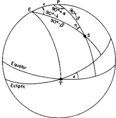
The fundamental formulas for these conversions are obtained from the trigonometric relations among the parts of the spherical triangle formed by the north pole of the ecliptic, the north celestial pole, and the given point of the celestial sphere (see Fig. 2). In this triangle the three sides are 90° — β opposite the angle 90° + ,α, 90° — ô opposite the angle 90° — λ, and the arc joining the two poles which is equal to the obliquity e; applying the formulas
of spherical trigonometry in Chapter 1 gives the relations sin ß = cos € sin δ — sin e cos δ sin a,
cos β sin λ = sin e sin δ + cos € cos δ sin a, (9) cos jS cos λ = cos (5 cos a;
sin δ = cos e sin β + sin € cos /? sin λ,
cos ό sin a = cos e cos /? sin λ — sin € sin β, (10) cos ό cos a = cos ß cos /.
Either transformation may be derived from the other by interchanging λ with a, and β with <5, and changing € to — €.
The angle η opposite the side € may be obtained from cos β cos η = cos c cos (5 + sin € sin δ sin a,
cos β sin η = sin e cos a;
(11) cos <5 cos η = cos € cos β — sin c sin /? sin A,
cos ό sin η = sin € cos λ.
Relative Coordinates
The positions of celestial bodies such as the satellites and the fainter components of double stars are more conveniently represented by their locations relative to the objects with which they are associated than by their actual coordinates on the celestial sphere. When the two bodies are very close together, as in the case of double stars and many of the satellites, the angular distance and the direction from the reference object are usually used for this purpose; when the angular distance is not small enough for this method to be convenient, as in the case of the more distant satellites of some of the planets, the differences of the right ascensions and declinations are often used.
Position Angle and Distance
The direction of one body from another is represented by the position angle, which is the angle at the reference object between the circle of declination through this object and the great circle through both objects, reckoned from north through east. Likewise, the positions of points on or near the disks of the Sun, Moon, and planets are often represented by the distance and position angle relative to the center of the disk.
The distance Δ and position angle px of a point 52(α2, δ2) from a point Si(ai> ^ι) m&y be found from the trigonometric relations in the triangle
formed on the celestial sphere by the two points and the north celestial pole (Fig. 3):
cos/?! sin Δ = cos δχ sin δ2 — cos(a2 — o^) sin ô± cos δ2,
sin/?! sin Δ = sin(a2 — ai) cos <52, (12)
cos Δ = sin όχ sin δ2 + cos(a2 — aj) cos δχ cos δ2.
These formulas are rigorous; but a difficulty is encountered in their applica- tion when Δ is a small quantity, because sin Δ is then small, and tan/?x and
cot Δ are obtained with fewer significant figures than were contained in the functions of a and ό. Such cases can sometimes be dealt with by taking the functions of a and δ to additional decimals. In practice, how- ever, the square of a2 — ax and the cube of δ2 — δ1 may often be neglected, and the formulas written :
Δ cos /?! = <52 — <$,,
F (13)
Δ sin /?i = (a2 — ax) cos δ2.
On the right, δ2 — δχ is the great circle arc intercepted on the circle of declination through Sx by the parallels of declination through, S1 and S2; and (a2 — ax) cos δ2 is the length of the small circle arc intercepted on the parallel of declination through S2 by the circles of declina- tion through Sx and 52. Equations (13) are equivalent to regarding the triangle CSXS2 as a plane triangle.
Differential Coordinates
The position of 52 relative to Sl9 referred to the equatorial coordinate system, is represented by the differences a2 — alf δ2 — ό1# In terms of the angular distance and position angle, they may be obtained from the rigorous equations (12); and from these equations approximations of any required order of accuracy may be derived. To the accuracy of (13),
a2 — OLX = Δ sin ρλ sec ό2, δ2 — δχ = Δ cos/?!.
The quantities
x = Δ sin/?!, y = Acos/?i FIG. 3. Relative coordinates.
are commonly referred to as the rectangular coordinates of S2 relative to Sx as origin.
To obtain differences of right ascension and declination from differences of ecliptic coordinates, or conversely, the expressions obtained by differen- tiating the spherical triangle formed by the celestial pole, the pole of the ecliptic, and a point of the sphere are ordinarily sufficiently accurate in practice. They may be found either by applying the appropriate differential formulas in Chapter 1, or by differentiation of the transformation formulas that connect equatorial and ecliptic coordinates, and they may be written in the form
(14) cos δ den = +cos η cos β άλ — sin η dß — sin ô cos a de,
do = +sin η cos β dk + cos η dß + sin a de;
cos β άλ = +cos η cos δ dat. + sin η do + sin ß cos λ de, dß = —sin η cos ô den + cos η dô — sin λ de;
in which the angle η is given by sin η = cos λ sec ô sin €
0 . - 9 0 ° < η < +90°
= cos a sec p sin e.
A variation Δί> in any latitudinal coordinate on the sphere displaces the point along a great circle to the full amount ύώ; but by a variation Δ/ in a longitudinal coordinate, the point is displaced along a parallel and describes only a small circle arc of angular length s = Δ/. When Δ/ is small, the great circle arc joining the end points of s departs very little from s; and to within the cube of Δ/, the equivalent great circle displacement is cos b Δ/, as shown in Chapter 1. For example, a variation Δα in right ascension produces a displacement of only the fraction cos à Δα on the celestial sphere.
Coordinate Systems in Space
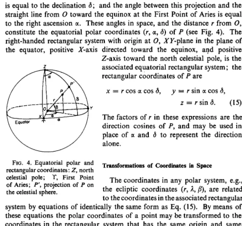
In some problems of spherical astronomy, three-dimensional coordinate systems, either rectangular or polar, are required. The origin O may be at any point in space, depending on the problem; but in accordance with the conception of the celestial sphere as mathematically infinite, the origin is always at the center of the sphere. A polar coordinate system in space and an associated rectangular system may, therefore, be defined by extending any coordinate system on the surface of the sphere to include the distance r from O in addition to the coordinates which represent the direction from O.
For example, the angle which the straight line from O to any point P in space forms with the projection of this line on the plane of the equator
is equal to the declination <3; and the angle between this projection and the straight line from O toward the equinox at the First Point of Aries is equal to the right ascension a. These angles in space, and the distance r from O, constitute the equatorial polar coordinates (r, a, ô) of P (see Fig. 4). The right-handed rectangular system with origin at O, ΑΎ-plane in the plane of the equator, positive A'-axis directed toward the equinox, and positive
Z-axis toward the north celestial pole, is the associated equatorial rectangular system; the rectangular coordinates of P are
x = r cos a cos δ, y = r sin a cos ô,
z = r sin <5. (15)
FIG. 4. Equatorial polar and rectangular coordinates : Z, north celestial pole; T, First Point of Aries; P\ projection of P on the celestial sphere.
The factors of r in these expressions are the direction cosines of P, and may be used in place of a and ô to represent the direction alone.
Transformations of Coordinates in Space
The coordinates in any polar system, e.g., the ecliptic coordinates (r, λ, β), are related to the coordinates in the associated rectangular system by equations of identically the same form as Eq. (15). By means of these equations the polar coordinates of a point may be transformed to the coordinates in the rectangular system that has the same origin and same cardinal reference directions as the polar system; solving Eq. (15) for the polar coordinates gives the reverse transformation.
If the XY-p\ane of a rectangular system does not coincide with the funda- mental plane of a polar system with the same origin, or if the positive Z-axis is not directed toward the point in this plane from which the longitudinal polar coordinate is reckoned, a transformation from one system to the other requires a rotation of the axes, in addition to Eq. (15). For example, to transform the ecliptic system to the equator system, a rotation around the line of equinoxes through an angle — e is required; and for the reverse transformation, a rotation +€. The equations that represent these rotations give the transformation from ecliptic rectangular coordinates (x\ y\ z') to equatorial coordinates (x,y, z), and the reverse:
x = x,
y = y' cos € — z' sin e, z = y sin € + z'cos e;
X = X,
y' = z sin € + y cos e, z' = z cos € — y sin e.
(16)
Expressing the right-hand members in terms of polar coordinates gives the transformations from polar coordinates in one system to rectangular coordinates in the other:
x = r cos ß cos λ,
y = r cos j8(cos e sin A — sin e tan β), z = r cos j8(sin € sin λ + cos e tan /?);
#' = r cos ό cos a,
y = /· cos <5(sin e tan <5 + cos e sin a), z' = r cos o(cos e tan δ — sin e sin a).
Similarly, expressing the left-hand members of Eqs. (16) in terms of polar coordinates gives the equations for transforming from rectangular coordinates in one system to polar in the other.
Expressing both members of Eqs. (16) in terms of polar coordinates gives the transformations (9) and (10) of spherical coordinates that were obtained trigonometrically. This is an example of the method which may be used in general to transform spherical coordinates by means of an appropriate rotation of rectangular axes instead of by spherical trigonometry; it is often an advantageous alternative in numerical calculations. In the right-hand members of Eqs. (16), the coefficients of the coordinates are the direction cosines of the axes of one system relative to the axes of the other system.
The transformations Eqs. (16) and (17) apply to any ecliptic and equator systems that have the same origin, irrespective of the point in space at which the origin is located. On the heliocentric celestial sphere, e.g., the ecliptic and the equator are in identically the same positions as on the geocentric sphere.
A transformation of coordinates to a system with a different origin requires a translation of the axes in addition to any rotations about the origin that may be necessary. A translation of a system of rectangular axes decreases each rectangular coordinate by the algebraic amount of the displacement of the origin in this coordinate. From this relation and Eq. (15), the effect on the polar coordinates may be determined. An example which occurs with great frequency in practice is the transformation of the heliocentric coordinates of a planet into its geocentric coordinates. In the equatorial system, the polar geocentric coordinates α, δ and geocentric distance Δ are usually obtained through the intermediary of the rectangular coordinates by means of the relations
xx + X = Δ cos a cos δ, yx + Y = Δ sin a cos <5,
ζλ + Z = Δ sin ô,
in which X, Y, Z are the geocentric coordinates of the Sun (i.e., the negatives of the heliocentric coordinates of the Earth), and xl9yl9 zx are the heliocentric coordinates of the planet; the coordinates of the Sun are tabulated for every day of the year in the American Ephemeris and other national ephemerides, and the rectangular heliocentric coordinates xl9 yl9 ζλ of the planet may be obtained from its ecliptic polar coordinates by Eqs. (17). The geocentric distance Δ may be obtained either from the rectangular coordinates or from the cosine law in the plane triangle formed in space by the Sun, the Earth, and the planet, Δ 2 = μ + R, _ ^ ^ ^
where r is the heliocentric distance of the planet, and R the geocentric distance of the Sun.
In the ecliptic system, the transformation from the heliocentric polar coordinates (r, /, b) to the geocentric (Δ, λ, β) is
Δ cos β cos λ = R cos /3@ cos A® + r cos b cos /, Δ cos β sin λ = R cos β® sin Λ,® + r cos b sin /, Δ sin β = R sin β& + r sin b,
in which R is the geocentric distance of the Sun, and λ@, β@ are its geocentric longitude and latitude. For many purposes, it is sufficiently accurate to neglect the latitude of the Sun.
Differential Variations
The small variations of the coordinates on the celestial sphere that are due either to small displacements of the point of observation, or to small changes in the position of the body in space, may often be expressed with sufficient accuracy by differential formulas obtained from the relations of the spherical coordinates to the position in space.
For example, from Eq. (15), by differentiation dx = - dr — z cos a dô — y dot., x
r
dy = - dr — z sin a dô + x da, r
dz = -dr + r cos ô dô; 2
r
Λ j , dy dx cos à dec = +cos a —^- — sin a — ,
r r
„ . . dx . Ä . dy kdz
do = —sin o cos a sin à sin a h cos o — .
r r r dr = cos ô cos a dx + cos ô sin a dy + sin Ô dz.
(18)