Abstract: We present the results of the environmental historical and geoarchaeological analysis of Rákóczifalva-Bagi- földek and Rákóczifalva-Rokkant-földek archeological sites in Jász-Nagykun-Szolnok County.1 They were discovered in the course of several hectares of archaeological excavations related to the Roman Age and Migration Period, especially the Sarmatian and the Gepids era. A significant number of Gepids sites and finds2 were found in both the investigated areas and the wider area of the site, in the middle reach of the Tisza valley. So the geoarchaeological and environmental historical analysis of the Sarmatian and Late- Sarmatian and Gepids sites in Rákóczifalva can also provide a model for the settling strategy and lifestyle of the Sarmatian and Gepids communities.3 The purpose of our work is to present how geoarchaeological and environmental historical factors impacted local settling and lifestyles in the Gepids communities and Sarmatian-Late Sarmatian communities as well4 during the Roman Age and the Migration Period. In addition, to demonstrate the relationship of the Sarmatian and Gepids communities and their environment in the Rákóczifalva site compared to other Gepids5 and Sarmatian and Late Sarmatian communities in the Great Hungarian Plain.6
Based on the number of objects containing animal bones and the amount of bones found in them, we can reconstruct considerable settling in the Celtic, Sarmatian, Gepids, Avar and Arpadian periods. The number of objects from the Linear Pottery culture (Great Hungarian Plain) and the Bodrogkeresztúr culture is high; however, the number of animal bones is low. On the basis of the bones discovered, we can count on a smaller settlement during the Tiszapolgár culture, the Hunyadihalom group, the Halomíros culture, the Gava culture and during the Scythians period.
In this paper, we present the results of the Sarmatian, Late Sarmatian and the Gepid findings since the largest number of animal bones (except the Avar period) turned up from these periods. Our aim was to compare the animal husbandry, meat consump- tion and hunting habits of the Oriental origin Sarmatians and the Germanic Gepids communities. Bone artefacts and bone anvils have been found in the archaeological material of both ethnic groups.
Keywords: Rákóczifalva, Sarmatian, Late Sarmatian, Gepids, geoarchaeology, pollen analysis, macrobotanical analysis, archaeozoology, bone anvil
STUDY SITE
Natural conditions of the area
In terms of the borders of the Rákóczifalva-Bagi-föld and Rokkant-föld sites, it can be said that it is pro- tected from the north, south and west, as it is bordered by the Tisza River and the deeper Tisza alluvium (Figs 1, 2, 3, 4, 5). It is open only from the eastern direction because the area is connected eastward to the high river bank of
AND GEPIDS SETTLEMENT OF RÁKÓCZIFALVA
BEÁTA TUGYA1,2 – KATALIN NÁFRÁDI2 – SÁNDOR GULYÁS2 – TÜNDE TÖRŐCSIK2,3 – BALÁZS PÁL SÜMEGI2 – PÉTER POMÁZI2 – PÁL SÜMEGI 2,3
1: Thúry György Museum, Zrínyi Street 62, H-8800 Nagykanizsa, Hungary tbea82@gmail.com
2: University of Szeged, Interdisciplinary Excellence Centre, Institute of Geography and Earth Sciences, Long Environmental Changes Research Team, University of Szeged Department of Geology and Palaeontology, Egyetem Street 2, H-6722 Szeged, Hungary
nafradikata@gmail.com; gulyas.sandor@geo.u-szeged.hu; ttorocsik63@gmail.com; sumegi.balazs.pal@gmail.com;
pomazi.peter9@gmail.com; sumegi@geo.u-szeged.hu
3: Research Centre for the Humanities, Institute of Archaeology, Tóth Kálmán Street 4, H-1097 Budapest, Hungary ttorocsik63@gmail.com; sumegi@geo.u-szeged.hu
Acta Archaeologica Academiae Scientiarum Hungaricae 71 (2020) 101–156 DOI: 10.1556/072 .2020.00005
1 Excavator Marietta Csányi.
2 Cseh 1986, Cseh 1990, Cseh 1991, Cseh 1992, Cseh
1993, Cseh 1997, Cseh 1999a, Cseh 1999b, Cseh 2001, Cseh 2002;
Masek 2014.
3 havassy 1998; IstvánovIts 1999; Masek 2012; Masek
2014; IstvánovIts–kulCsár 2018.
4 kováCs et al. 2007, kováCs et al. 2008; kováCs–váCzI
2007; Masek 2012, Masek 2014.
5 B. tóth 1999, B. tóth 2006.
6 havassy 1998; Masel 2012, Masel 2014; IstvánovIts– kulCsár 2018.
Fig. 1. The location of the study site in Hungary and in GoogleMaps
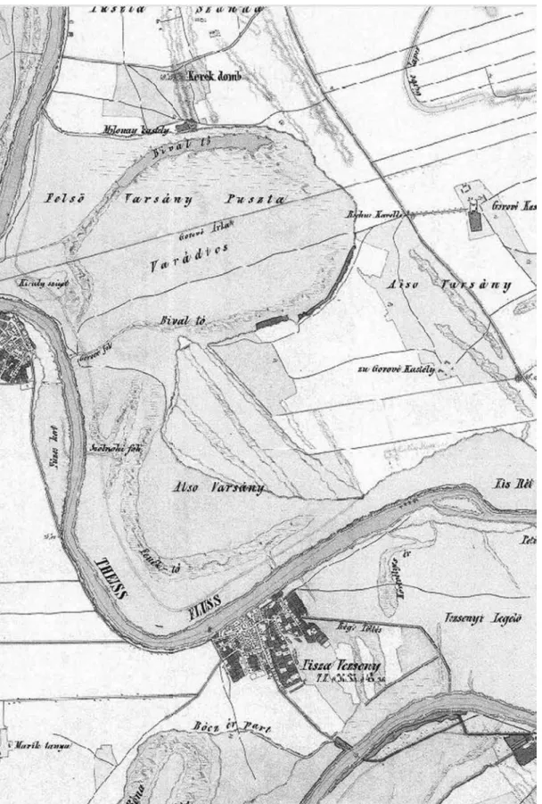
Fig. 2. The morphological conditions and the vegetation of the study site in the First Austrian Military Survey (1782)
Fig. 3. The morphological conditions and the vegetation of the study site in the Second Austrian Military Survey (1869)
Fig. 4. The morphological conditions and the vegetation of the study site in the Third Austrian Military Survey (1875)
Fig. 5. The morphological conditions and the vegetation of the study site in the Hungarian Military Survey (1943)
the Tisza River and it extends as a peninsula into the deeper Tisza floodplain. The study site belongs to the Great Hungarian Plain, including the Middle Tisza region, the Nagykunság little region group and the Szolnok-Túri plain, Szolnok-Ártér little regions. It lies in the western part of the Szolnok-Túri plain. The relative relief value of the little region is low, 2 m/km2. The slightly wavy plain in the study site and the floodplain at the edge of the Tisza River can be classified as orographic relief type.7 Examining a 1:10.000 scale map, the deepest point of the area is 79.2 m, and the highest is 90 m. Despite the low relative relief value of the Szolnok-Túri plain, there is a difference of more than 10 m above sea level difference within a short distance in the study area. This value is extremely high in the Great Hungarian Plain, especially if we consider the general nature of the little region.
The above-mentioned little regions have a moderately warm-dry climate, close to the warm-dry climate.
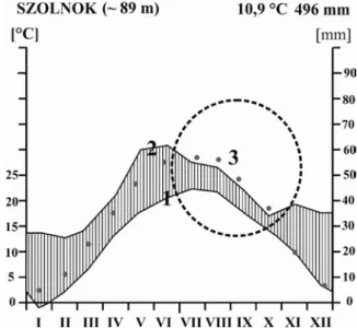
The annual sunshine duration is between 1970 and 2010 hours. The average annual temperature is 10.9 ºC: the mean temperature of the vegetation period is 17.3–17.4 ºC. The frost-free period begins on 7th–8th April, the first autumn frosts are expected around 20th October. So the frost-free period is 196 days long. Annual precipitation is 510–540 mm, the growing period’s precipitation amount is 300 mm. The aridity index is 1.3–1.38. The area is a dry, heavily anhydrous area. Precipitation is 150 mm less than the local value of the potential evaporation.8 Based on the data of the Szolnok meteorological station and the Walter–Lieth diagram9 (Fig. 5), the area belongs to the driest areas of the Great Hungarian Plain. On the basis of the average annual rainfall of 500 mm and the distribution of rainfall (Fig. 6), there is a significant risk of drought in the second half of summer and in autumn. This occurs especially when continental and/or sub-Mediterranean climate effects develop, resulting in maximum monthly temperature conditions (Fig. 6) in the examined area. In this case, evaporation exceeds rainfall at the end of summer and early autumn, and periodic steppe climatic conditions develop.
Based on the bioclimatic analysis of the Carpathian Basin,10 the study site belongs to the central part of the Pannonian forest steppe zone (Fig. 7). At the same time, the little regions belong to the Tiszántúl flora region. Po- tential forest associations are willow-poplar-alder gallery forest, oak-ash-elm gallery forest, alkaline oak forest and loess-mantled terrain (Aceri tatarico-Quercetum) in the floodplain.11 Vegetation development and its change will be analyzed later, as we have a pollen core from the area that was revealed by the Department of Geology and Paleon- tology of the University of Szeged. Based on the recent plant associations, the examined area is a cultivated steppe:
7 MarosI–soMogyI 1990.
8 MarosI–soMogyI 1990.
9 Walter–lIeth 1960.
10 szelepCsényI et al. 2014, szelepCsényI et al. 2018.
11 MarosI–soMogyI 1990.
Fig. 6. Walter–Lieth diagram based on the meteorological station in Szolnok.
1=monthly average temperature values; 2=monthly average precipitation values;
3=dashed circle, drought period, red circle=monthly maximum temperature values
pastures with weeds, poplar and acacia plantations, in deeper areas swamp vegetation mixed with weeds or with saline plants occur.
On the basis of the cores of the Department of Geology and Paleontology, University of Szeged two types of recent soils can be distinguished in the area. One of them is the chernozem soil that can be found on natural el- evations, and the other is the alkaline meadow soils (Fig. 8) which have a significant water effect.
Fig. 7. Position of the analyzed region on spatial distribution of the Carpathian Region’s core and transitional life zones for the beginning of 20th century based on the Holdridge modified life zone system (szelepCsényI et al. 2014, szelepCsényI et al. 2015, szelepCsényI et al. 2018)
The results of the Kreybig soil mapping (1933) and pedological mapping (Fig. 8) were used to character- ize the soils of the examined area.12 In this historical map, alluvial meadow, chernozem, alkaline and sandy soil types were identified in the study site, but in a different spatial extension compared to our results.
GEOLOGY AND EVOLUTION OF THE AREA
Since only Quaternary formations could be detected on the surface of the examined area (Figs 9, 10), the geological development history of the area is presented by discussing Quaternary events. The bedrock of these Quaternary formations is Tertiary sediments lying more hundred meters deep from the surface. Among these, the most significant layer is the Törteli Formation13 that developed at the end of the Tertiary, in the last phase of the Pannonian filling up. The Zagyva Formation developed on the Törteli Formation.14 Thin-layered clay, aleurite and sandstone layers accumulated indicating a delta background, presenting marshy and floodplain environment. Its upper level evolved in an alluvial plain, in a fluviolacustrine environment. After the fluviolacustrine state, the water network of the Great Hungarian Plain changed and was significantly different from the current water network: the Tisza river flowed eastern than nowadays. The Danube River met the Tisza at the height of Csongrád.15 According to the latest data16 the Tisza valley was formed about 20,000 years ago. The Tisza River, which until then followed the valley of the Körös and Berettyó creeks, bypassed the Nyírség from the north and took its current direction.17
12 kreyBIg 1937.
13 Juhász 1992.
14 Juhász–Magyar 1992; Juhász 1992.
15 süMeghy 1944, süMeghy 1953; MIháltz 1953;
Molnár 1965.
16 tIMár et al. 2005.
17 süMeghy 1944.
Fig. 8. Pedological map of Lajos Kreybig (1937) about the study site (indicated as Felső and Alsó Varsány-puszta in the map).
brown color=chernozem soil, blue color=hydromorphic soil, purple color=alkaline soil, yellow color=sand soil
Thus, in the Tisza region, the Tisza River became significant regarding morphology and sedimentology from the Upper Wurmian (MIS2).18 Due to tectonic movements sediments (of Tisza origin) of different age in different alti- tudes can be found in the area.19 So it is not surprising that upper Pleistocene-Holocene sediments cover the surface in Rákóczifalva-Bagi-föld and Rokkant-föld sites. Older Pleistocene layers and the Pliocene bedrock sediments (clay, sand) are known only from drilling. 20
18 süMegI et al. 2018.
19 rónaI 1972, rónaI 1985,;tIMár et al. 2005.
20 rónaI 1972, rónaI 1985.
Fig. 9. Geological structure of the study site
(based on the 1:100 000 scale geological map of the Hungarian National Geological Institute, 1969)
Fig. 10. Geological cross section of the study site
(based on the 1:100.000 scale geological map of the Hungarian National Geological Institute, 1969)
The most widespread upper Pleistocene sediment on the surface is loess; the type of loess that is connected to rivers and floodplains, i.e. a Pleistocene floodplain sediment,21 formerly known as loess like Pleistocene alluvial sediment or better-known infusion loess (alluvial loess). Infusion loess differs from typical loess in its porosity, carbonate and clay content and biofacies.22
In the Middle Tisza region, there was also sand movement, which can be observed today north of the ex- amined area in Szolnok-Szandaszőlős. The sandy area of Tiszaföldvár at the southern part of the Szolnok-Túri plain is the continuation of the sandy area of the Danube–Tisza Interfluve.23
The results of the geological mapping were compared with the results of the geological map of József Sümeghy and András Rónai. The 1:200.000 scale geological map of the Tiszántúl (1941) by Sümeghy and the complex maps of the Great Hungarian Plain (Fig. 9), the 1:100.000 scale Szolnok map sheet made by András Rónai.
In the Sümeghy map, ‘old-Holocene’ and ‘new-Holocene’ alluvial soil surrounded the island-like ‘upper Pleistocene lowland loess’ formation. The expansion and position of the loess formation in the Great Hungarian Plain is very similar to that of the alkaline soil ‘island’ surrounded by alluvial soil in the Kreybig map.
The results of the mapping of the Great Hungarian Plain led by A. Rónai are similar, although it showed a more inaccurate result in the examined area.24 Their cross-section of several drillings is slightly south of our study area; two drillings were conducted in the study site (Fig. 10). Based on their map, infusion loess covered (floodplain sediment) surface was explored in the area, and the residual surface was surrounded by deeper Pleistocene and Holocene channels and beds filled with fine-grained sediments and still developing alluvial plains (Figs 9, 10).
The geological surveys before our study pointed to Pleistocene muddy loess and infusion loess (floodplain) sediments in the Rákóczifalva-Bagi- and Rokkant-földek sites. In the middle of this sediment Pleistocene loessy sand was found, according to these maps. In the northern part of the area, semi-circular shaped Holocene aleurite appeared (Fig. 9). East of this area the residual surface is covered by Pleistocene muddy loess and infusion loess.
The southern area is not uniform in a geological point of view. From east to west the map indicates loess (aleurite rich sediment), muddy loess, infusion loess (floodplain sediment), riverine sand, loessy sand and close to the Tisza River muddy, infusion loess occurs again.
METHODS
Analysis of historical maps of the site
Examination of the maps before and after river regulations (1847) is as follows. Although the study site can be recognized in the maps of Ptolemaiosz (Fehér 2004), Tabula Peutingeriana from the end of Antiquity,25 Angelino Dulcert from the medieval period (1339)26 and in the map of Lázár deák from 1528,27 but the first maps that can be evaluated from an environmental historical point of view are the maps from the 18th century (AD). The First (1782), the Second (1869) and the Third (1875) Austrian Military Survey and the Hungarian Military Survey28 from World War II were used in our study. We also used the Middle Tisza region map29 of Lietzner–Sándor (1970) by János Lietzner Keresztelő, the county engineer of the County Heves-Külső Szolnok (Fig. 11). By analyzing historical maps, we tried to reveal the development of the area and the effect of human impact.
21 süMegI 2005; süMegI et al. 2015.
22 horusItzky 1898, horusItzky 1899, horusItzky
1903, horusItzky 1905, horusItzky 1909, horusItzky 1911; péCsI
1993; süMegI et al. 2015,
23 halaváts 1895; MIháltz 1953; Molnár 1965; rónaI
1972, rónaI 1985.
24 rónaI 1969, rónaI 1972, rónaI 1985.
25 tóth 2004.
26 Írás 2013.
27 török 1996.
28 stegena 1981; tIMár et al. 2006.
29 sugár 1989.
Exogenous geological analysis
An EOV map with a scale of 1:10,000 is available from the area. Using this map, we have calibrated the measurement points using ArcView 3.2 software. After that, we created the digital relief model of the area (1:10000 EOV map) using ArcGIS software. The digital relief model was used for the geomorphological analysis of the study site. In addition, we used the aerial photographs prepared by the Archaeological Institute of the Eötvös Loránd University to map the local surface of the area. The purpose of the exogenous geological-morphological analysis was to reconstruct the environment of the site as accurately as possible.
Geoarchaeological analysis
During geoarchaeological analysis 300 shallow (3–5 m deep) cores were taken at 5 cm intervals by a spi- ral drilling machine (süMegI, 2001, süMegI 2002, süMegI 2013) in Rákóczifalva–Bivaly-tó, Bagi-földek and Rok- kant-földek site. Boreholes were created along geological sections parallel to each other in such a way that all exogenous geological-geological-pedological units were explored. We used the international nomenclature of Troels-Smith30 during sediment description.
Undisturbed samples were taken by a Russian corer31 by overlapping technique32 in a filled up point bar channel at the boundary of the Rokkant-földek and Bagi-földek sites. Samples were cut lengthwise and stored in the usual manner at 4˚C.33 Size distributions, organic material, carbonate content (LOI) and pollen analytical analy- sis was carried out. In describing the colours of the sediment, the Munsell soil colour charts were used.34 The sedi- mentological analysis was carried out using an Easy Laser Particle Sizer 2.0. laser particle sizer (42 grain fractions) after proper sample preparation.35
30 troels-sMIth 1955.
31 Belokopytov–BeresnevICh 1955.
32 süMegI 2001, süMegI 2002, süMegI 2013.
33 süMegI 2001, süMegI 2002, süMegI 2013.
34 Colour 1991.
35 süMegI et al. 2015.
Fig. 11. The map of the study site by Sándor Lietzner (1790)
During magnetic susceptibility analysis, the magnetizable element content of the sediment is measured.
For this purpose, air-dried and powdered samples are prepared to measure the loss of mass. Bartington MS2 Mag- netic Susceptibility Meter was used at 2.7 MHz36 that is suitable for laboratory and field analysis as well. Three measurements were done for each sample and values were averaged.
Dean’s method (1974) was used for the determination of carbonate and organic material content. Sedimen- tological and LOI analysis was carried out and interpreted at 4 cm intervals. We presented the sedimentological data and succession, and the cross-section of geoarchaeological data using the Psimpoll software by Keith D. Bennett (1992).
Pollen analyses
Pollen analytical analysis was carried out on the undisturbed samples of the core deepened in the point bar channel. The retrieved cores were also subsampled at 1–2–4-cm intervals for pollen analysis. A volumetric sampler was used to obtain 2 cm3 samples, which were then processed for pollen.37 Lycopodium spore tablets of known volume were added to each sample to determine pollen concentrations. A known quantity of exotic pollen was added to each sample in order to determine the concentration of identified pollen grains.38 A minimum count of 500 grains per sample (excluding exotics) was made in order to ensure a statistically significant sample size.39 The pollen types were identified and modified according to Moore et al. 1991, Beug 2004 and punt et al. 2007, kozáková– pokorny 2007, supplemented by examination of photographs in reIlle 1992, reIlle 1995, reIlle 1998 and of reference material held in the Hungarian Geological Institute, Budapest. Percentages of terrestrial pollen taxa, ex- cluding Cyperaceae, were calculated using the sum of all those taxa. Percentages of Cyperaceae, aquatics and pteridophyte spores were calculated relative to the main sum plus the relevant sum for each taxon or taxon group.
Calculations, numerical analyses and graphing of pollen diagrams were performed using the software package Psimpoll 4.26.40 Local pollen assemblage zones (LPAZs) were defined using optimal splitting of information con- tent,41 zonation being performed using the 20 terrestrial pollen taxa that reached at least 5% in at least one sample.
The paleovegetation was reconstructed using the works of sugIta 1994, soepBoer et al. 2007, JaCoBson– BradshaW 1981, prentICe 1985 and MagyarI et al. 2010.
Pollen extraction was carried out with the help of Tibor Cserny geologist, in the former laboratory of the Hungarian Geological Institute.
Macrobotanical analysis
The archaeobotanical material (anthracological) was obtained from the samples collected by 4 to 10 cm, flotated from uniformly 2.7 kg of samples. The quantity of the samples is in accordance with the German stand- ards.42 In obtaining and processing the samples, we followed the guidelines of Ferenc Gyulai (gyulaI 2001) regard- ing the sampling and flotating process. In flotating the samples, the dual flotating method and 0.5 mm and 0.25 mm sieves were used.43
Charcoal material was analyzed using a Zeiss Jenapol optical microscope at 10, 20, 50 and 100× magni- fication.44 Wood identification was carried out using the reference book of greguss 1945, greguss 1972 and sChWeIngruBer 1990 and the web-based identification work of sChoCh et al. 2004.
36 süMegI et al. 2015.
37 Berglund–ralska-JasIeWICzoWa 1986.
38 stoCkMarr 1971.
39 Iversen-FægrI 1964; FægrI-Iversen 1989; punt 1976–
1995; Moore et al. 1991.
40 Bennett 2005.
41 BIrks–gordon 1985.
42 JaCoMet–kreuz 1992.
43 náFrádI–süMegI 2013.
44 náFrádI–süMegI 2015.
Archaeozoological analysis
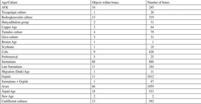
A large volume of bones, more than 6000 pieces of animal bones occurred from ten archaeological cultures in the study sites, from the middle Neolithic (AVK) to the Arpadian Age. So the area was often inhabited for thou- sands of years. In addition, there were also objects of Copper Age (Tiszapolgár culture, Bodrogkeresztúr culture), Bronze Age (Tumulus culture, Gáva culture), Celtic, Sarmatian and Avars with more or less vertebrate remains.
Most of the finds are well preserved, only some of the prehistoric bones were in poor condition, often heavily laced, which made the determination difficult. Altogether 979 pieces were found in Gepid archaeological objects that were in excellent condition. Identification of bones was carried out using the reference books of sIsson 2014 and sChMId 1972, and the work of vonden drIesCh 1976 for bone size measurement.
RESULTS
Historical maps
The analysis of historical maps (Figs 2–5) clearly shows the transformation of landscape utilization in the study sites before and after river regulation processes (1847). Although in the First Austrian Military Survey (Fig. 2) the nomenclature is still very poor and the morphological survey was not entirely accurate, in addition, the mapping of the Tisza coast was rough, it was obvious that in the coastal area of Tisza River (in the Bagi-földek site, accord- ing to archaeologists) there were only gallery forests suitable for floodplain farming and marshy, boggy areas. It was also clearly visible in the First Austrian Military Survey (1782; Fig. 2) that in the Rokkant-földek (as it is called by archaeologists) in the area called Varsány Puszta (in the later survey Alsó Varsány (Fig. 3) and Alsó Varsány puszta (Fig. 4)) there are two periodic creeks between the Bivaly Lake and the Tisza valley. The first Austrian military map does not indicate the name of the Bivaly Lake; only a temporary, swampy area is marked. An aban- doned, over-developed, unregulated curve of Tisza River can be reconstructed from its drawing (Fig. 2).
In other parts of the area scattered gardens, arable lands, grazing fields representing extensive animal husbandry are indicated in the first Austrian military map (Fig. 2). In addition, several mounds that help location identification are shown in the study area (Fig. 2).
Table 1. The number of objects which contain animal bones and the number bones in every period
Age/Culture Objects within bones Number of bones
AVK 16 245
Tiszapolgár culture 1 26
Bodrogkeresztúr culture 13 219
Hunyadihalom group 2 31
Copper Age 2 64
Tumulus culture 4 79
Gáva culture 3 31
Bronze Age 1 1
Scythians 1 18
Celts 9 628
Prehistorical 5 25
Sarmatians 88 886
Late Sarmatians 11 244
Migration (Dark) Age 1 11
Gepids 11 1012
Sarmatians + Gepids 1 47
Avars 66 1059
Árpád Age 18 533
New Age 2 2
Undifferent cultures 13 592
The Second Austrian Military Survey (1869) is critical in an exogenous geological and morphological point of view (Fig. 3). Bivaly Lake has been shown in this map, which clearly shows that it is an earlier over-de- veloped curve of the Tisza River, which was connected to the regulated Tisza River through water outlet (canal) only periodically, during floods (Fig. 3). From this area of the Bivaly Lake (Felső (Upper) Varsány puszta), through Alsó (Low) Varsány puszta, four deeper, canal-like formations led to the actively developing valley of the Tisza (called Bagi-földek in our work). According to the map of Lake Fenék, there was a lake in the area of Bagi-földek.
This lake was connected to the active Tisza River through the water outlet of Szolnok. Based on the map, the Bagi- földek was a suitable area for fishing, gathering, waterfront farming (gathering of gallery forest crops, sedge, reed, construction and wood utilization for energy) before river regulations. On the basis of exogenous geological char- acters, the Bagi-földek was a point bar series of the unregulated Tisza River (Fig. 3).
At the same time, in the second Austrian military map, Rokkant-földek (Alsó (Lower) Varsány) is an older (probably Pleistocene) residual surface, a point bar series rising a few meters above the alluvium of Tisza River.
It did not affect the development of the Tisza alluvium at the end of the Pleistocene, and during the Holocene, in- stead, it seems to be a terrace level (Fig. 3). The second Austrian military map (1869) clearly shows the traces of groundwater regulation, the groundwater drainage ditches and the artificial barrier system along the active riverbed of the Tisza River (Fig. 3). At the same time, settlements and the associated gardens and arable lands are extensive, while grazing fields and pasture lands can be observed in smaller regions further from the settlements and are more clearly defined than in the First Austrian Military Survey (Fig. 3).
Based on the map prepared by the Second Austrian Military Survey (1869), it is clear that north from the Bagi-földek, on the alluvium of the Tisza River called Varsány puszta, there is a large abandoned Tisza River chan- nel, the Bivaly Lake, which has been transformed into an oxbow. At the same time, south from the Bagi-földek the point bar series in the riverbed of the Tisza River (that is younger than the Bivaly Lake) is called Fenék Lake (Fig.
3). In the Bagi-földek (Alsó (Lower) Varsány in the second military survey) that is emerging from the Tisza alluvium there are more channel like hollows (Fig. 3), older point bar channels a few hundred meters apart from each other.
Bagi-földek is located in a peninsula-like form in the Tisza alluvium. Its eastern part has already been utilized as a ploughland, but the surface above the point bar channels has been utilized as pasture land (Fig. 3).
The Third Austrian Military Survey (1875) shows the impact of river regulation, the drainage channels, the formation of a barrier system along the Tisza River, the development of the floodplain area between the dams and the development of settlements. In addition, the geographical names and the exogenous geological units that were already noticed and described in the Second Austrian Military Survey (Fig. 4) can be observed.
In the Hungarian Military Survey (1943) dam-system protected settlements, roads, the extension of arable lands and garden cultures and the transformed landscape and agricultural system as a result of river regulation and groundwater drainage can be observed (Fig. 5). The nomenclature of the Hungarian Military Survey was used by the geologists of the Hungarian Royal Geological Institute and the Hungarian Geological Institute during the geo- logical and pedological mapping of the Great Hungarian Plain (Figs 8, 9, 10).
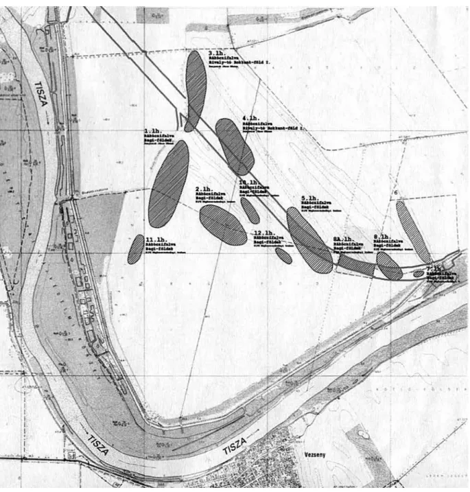
In the Lietzner–Sándor map of 1790 (Fig. 11), the recording of the Middle Tisza region was completed.45 In this map, the emerged location of the point bar structure of the Rokkant-földek and the deeper location of the Bagi-földek associated with the Tisza alluvium can be clearly seen (Fig. 11). In addition to the analysis of historical maps, we prepared the digital elevation model (Figs 12, 13) of the area to understand the exogenous geological situation and morphological conditions during the Sarmatian and Gepids era. The 1:10000 scale digital elevation model clearly demonstrates the existence of a point bar series in a deeper position that is related to the unregulated Tisza riverbed and developed in the curve of the Tisza River over a few centuries. To the northeastern direction in an elevated position (residual surface or terrace level), a series of an older point bar can be found (Figs 12, 13).
Based on the digital elevation model, the Bagi-földek site is located in the deeper and younger alluvium of the Tisza River characterized by good water supply. The Rokkant-földek site in an older residual surface which is rising above the alluvium. In this older point bar series, only periodic flood water flew through the point bar channels from the direction of the Bivaly Lake towards the Tisza alluvium (Figs 12, 13). So Sarmatian and Gepids communities settled in the point bar series of the high and low floodplain. These surfaces provided different farming possibilities for the Sarmatian and Gepids communities of the Migration Period: the utilization of the gallery forest,
45 sugár 1989.
gatherings in the area of the forests and floodplain, fishing and hunting, extensive animal husbandry on the higher, drier areas and plant cultivation around the settlements and houses.
As our goal was to reconstruct the environmental history of the Sarmatian and Gepids settlement as com- plex as possible, we conducted geoarchaeological drillings (Fig. 14) along a double geological section that explored the deeper (Bagi-földek) and the higher (Rokkant-földek) point bar series as well (Fig. 14). Based on these drillings,
Fig. 12. Digital elevation model of the study site
Fig. 13. 3D drawning of the study site on the basis of the digital elevation model
the geological and pedological conditions of the exogenous geological and geomorphological units could be mapped and the environmental, geological and pedological characters of the Sarmatian and Gepids communities could be specified (Fig. 14).
After the formation of the geological profile (Figs 14, 15) it was confirmed that the point bar series in the Rokkant-földek developed at the end of the Pleistocene. This is proved by the loess-like sediment layers of the point bar channels excavated by drillings, the relatively high position, and the carbonate and coarse aleurite-rich sedimen- tary environment. The deeper geological position of the Bagi-földek is of Tisza alluvium origin, its clay and organic material rich geological layers support its Holocene formation and development (Fig. 15).
The Bagi-földek got continuous water supply through the water outlet system of the Tisza, until to the Tisza River regulation processes and dam building; so in the Migration Period, at the time of the settling of the Sarmatian and Gepids communities, there could not be permanent settlements in this area only in higher elevations (Rokkant- földek), in the semi-peninsula-like Pleistocene point bar series (Figs 12–15). Since the Pleistocene higher, flood-free surface is semi-circular, peninsula-like (Figs 11–14), the settling of archaeological cultures, including the Sarmatian and Gepids houses and settlements in the Rokkant-földek, follows a camber form (Fig. 16). So, the Sarmatian and Gepids communities lived in the boundary of two different local ecoregions, in the edge of a flood-free area that has good water supply, in a protected, elevated area surrounded by living waters (Figs 12, 13, 16). This settling strategy, the closeness of living water, the high position, the flood-free island-peninsula-like Pleistocene residual surface for settling, animal husbandry and plant cultivation in the Great Hungarian Plain was established since the Early Neolithic. The first data on this type of land utilization was published by Tibor Mendöl, a Hungarian social geography researcher in 1928 and 1929, before the recognition and phrasing of the culture.46 Mendöl made a colorued contour map of Szarvas and its surroundings, including the so-called Érpart, a Neolitic settlement. He recognized the Pleistocene loess covered higher, flood-free surfaces and ascribed them to the area of Neolithic set-
Fig. 14. The location of parallel geological sections and geoarchaeological drilling points in the digital elevation model of the site
46 Mendöl 1928, Mendöl 1929.
tling, farming and livestock breeding. He also described the periodically flooded floodplains that were covered by reed, gallery forest and tussock sedge and were utilized for hunting and gathering. This theory has been repeatedly reinforced during environmental and geoarchaeological research in the Tisza River and its adjacent valleys.47 So the Sarmatian and Gepids communities utilized one of the most important features of the Great Hungarian Plain, i.e. its local (few hundred m2 to a few km2), mosaic-like nature. Thus, the settlements were in a transition zone regarding regarding the geomorphological (Fig. 16). As a result, the elevated chernozem soil covered surfaces (cereal cultiva- tion, gardens) and areas of alluvial soils (floodplain forest management, grazing, gathering, meadows fields), saline soils (sheep grazing), the canal lakes, living waters (fishing) and water outlet channels (wells) were located within 5 km, approximately one hour walk from the Sarmatian and Gepids settlements. So, all food-producing areas were reached by the members of the Sarmatian and Gepids community within an hour walk (within a 5 km radius). In addition, the semi-circular, peninsula-like settling in the Tisza floodplain and alluvium provided significant protec- tion in the Great Hungarian Plain.
Sedimentological analysis
At the 7th drilling point of the first geological core section, a 3 m deep undisturbed core was taken with overlapping technique in the Pleistocene point bar channel. During the drilling, the following layers were described by the method of Troels-Smith (1955). Magnetic susceptibility, particle size analysis, LOI and water-soluble element content analysis were investigated. The Late Holocene near the surface part that is significant regarding the Sarma- tian and Gepid era and the Roman Age and Migration Period were sampled at 2 cm intervals for sedimentological and water-soluble elements content, while the Pleistocene and Early Holocene bedrock level at 4 cm intervals.
In the bedrock between 300 and 240 cm yellowish-grey (Munsell colour 10 YR 7/4) slightly cross-lami- nated sandy aleurite, aleuritic sand developed. The layer gradually transformed towards the surface and a parallel laminated structure appeared, and fine sandy coarse aleurite, coarse aleuritic fine sand dominated sediment layer developed. In this level carbonate filled root structures appeared, called biogalleries. Grain size indicates coarse grains, although grain size distribution is variable; the organic material content is low, while the carbonate content is the highest. Magnetic susceptibility (MS signal) and the sediment and LOI content indicate minimal changes in
Fig. 15. Geological section of the Bagi-földek and Rokkant-földek in Rákóczifalva and the layers of the cores (troels-sMIth 1955 symbols).
A.S.L.=Above Sea Level; *=undisturbed core sequence for pollen analyses; A – A’=geological section
47 nandrIs 1970, nandrIs 1972; kosse 1979; sherratt
1982, sherratt 1983; CreMasChI 1992; süMegI 2003, süMegI 2004;
süMegI–Molnár 2007; süMegI 2012; süMegI et al. 2012.
the development of the layer, but the changing values of water-soluble elements suggest significant water cover and cyclic drying periods.
The development of laminations occurred at a maximum thickness of 1 cm, and it is likely that in this interval we could have reconstructed stronger cycles of sedimentation and development due to the sedimento- logical changes of the sample. The development of the layer can be linked to the active evolving stage of the Pleistocene point bar and the late phase of the channel filling up. Due to its emerged position, its high carbonate content and water-soluble Ca and Mg content, the point bar did not belong to the sedimentation area of Tisza River.48 Probably the development of the point bar was the result of the development of the catchment area of the Danube River.
Fig. 16. The location of the archaeological sites in Rákóczifalva and the Gepid settlement
48 Molnár 1965.
Grain size distribution changed between 240 and 160 cm. Sand content decreased in this level of the pro- file and yellowish-brown (10 YR 5/6) fine aleuritic coarse aleurite, coarse aleuritic fine aleurite dominated layer developed. In the near-surface part of this level, a significant sand fraction rise occurred that can be linked to an extraordinary flood period. The carbonate content increased considerably as well as organic material content, how- ever this latter less in the colour of the sediment appeared. The slightly reddish shade was associated with an a in- crease of water-soluble iron.
Based on the development of the sediment and sediment parameters, the point bar could gradually emerge due to the appearance and incision of the Tisza River. As a result, the active development of the point bar was com- pleted and transformed into a drainage system at the end of the Pleistocene. In this level of the profile, a flood cycle could be detected based on significant sand intercalation according to grain composition analysis. This level devel- oped at the end of Pleistocene; however, this whole layer was clearly evolved in a stagnant water environment. The development, appearance and facies of the sediment are specific to point bar loess, floodplain sediments formed at the end of the Pleistocene.49
Between 160 and 70 cm (10 YR 4/2) clayey fine aleurite accumulated. The organic material content in- creased, the carbonate content was steady, indicating major soil formation and weathering at the early stage of Holocene. At the same time among water-soluble elements, Fe content decreased. This may indicate a deeper groundwater location and post-movement of elements after water regulation processes of the 20th century, and the cyclic change of groundwater level may be indicated by the cyclic change of other water-soluble elements. The development of this sediment layer can be linked to soil formation and more favourable weather conditions at the beginning of the Holocene; in addition, to the leaching of sediments with significant clay and organic material
49 süMegI et al. 2015.
Fig. 17. Sedimentological and geochemical results from the undisturbed core sequence of an infilled point-bar channel in Rokkant-földek at Rákóczifalva
content. However, element composition could have changed as a result of groundwater level decrease associated with modern water regulation as well.
Between 70 cm and the surface a slightly polyhedron structured, blackish brown (10 YR 3/1), clay-rich fine aleurite with significant organic material content developed and soil formation has started. This layer may be marshy-eutrophic lake sediment initially, but its element composition has changed as a result of soil formation and modern water regulation. The latter is primarily shown by the reduction of water-soluble Fe content and the less significant MS signal. Although the layer where soil formation has started represent hydromorphic soil formation characters (polyhedron structure), the significant water-soluble Na and K content indicate salinisation and an up- ward moving groundwater system with significant water-soluble elements in the capillary zone. As a result, besides hydromorphic soil formation, saline soil development started in the area as well. These processes were observed already in the 20th century during the geological survey and agrogeological (pedological) mapping of the area50
According to our data, during the Migration Period, during the existence of the Sarmatian and Gepids kingdom,51 an organic material rich lake-swamp system appeared in the examined area. This layer has transformed due to soil formation that was the result of the modern river and groundwater regulation.
Pollen analysis
According to the pollen analysis carried out on samples of the point bar channel, 10 pollen units (pollen horizons) were separated in the profile.
The first pollen horizon developed between 300 and 240 cm. Statistically evaluable pollen material did not occur; only a few samples contained scattered Gramineae and Pinus pollen indicating drying processes.
The second pollen horizon evolved between 240 and 210 cm. Statistically evaluable terrestrial pollen materials were found that reached the minimum of 500 pieces of pollen grains.52 In this level, the non-arboreal pol- len (NAP) material exceeded 60% while arboreal pollen (AP) grain ratio was below 40% with Pinus subgenus Pinus taxa, which can spread to significant distances (Fig. 18). On the basis of the pollen composition, a Pleistocene open parkland with scattered pine trees and willow-alder trees existed. In addition, grassy cold steppe vegetation devel- oped in the environment of the area at this time.
The third pollen zone developed between 210 and 170 cm. The pollen composition did not change, but the proportion of AP exceeded 50% (Fig. 18). This indicates a cold forest steppe (allen et al. 2000, prentICe et al.
1996) at the end of the Pleistocene (Fig. 18). The rise of woody vegetation ratio was caused by an increase in the proportion of Pinus genus, which can spread to significant distances. Thermo- and mesphillous elements could not be detected among deciduous trees; only narrow-leaved trees appeared such as willow and alder with higher toler- ance-level. Compared to the previous zone humidity increased.
The fourth pollen horizon developed between 170 and 130 cm. AP ratio was between 50 and 60%; although the amount of deciduous trees and shrubs, especially birch (Betula) and hazel (Corylus) are higher. Mixed forest steppe developed. Among woody vegetation coniferous trees and birch (Betula) dominated while herbaceous taxa indicate grasses-wormwood-pigweed dominated. Cold steppe, forest steppe existed with patches of trees.
The fifth pollen zone developed between 130 and 110 cm. The ratio of coniferous trees remained signifi- cant, while the proportion of deciduous trees and shrubs increased, especially the ratio of birch (Betula; Fig. 18).
Thermo-mesophillous (oak, ash, elm, lime) pollen appeared and AP ratio rose to 60–70%, which corresponds to the forest steppe phase (allen et al. 2000, prentICe et al. 1996) and to the northern part of the Euroasian forest steppe zone;53 in addition to the forest steppe zone mixed with taiga in the drier basins of the Altai region.54 This pollen horizon corresponds to the transition phase of the Pleistocene and Holocene.
The sixth pollen zone developed between 110 and 80 cm (Fig. 18). The ratio of coniferous elements de- creased, as well as that of herbaceous taxa. AP ratio decreased to 50–60% that corresponds to a temperate forest steppe55 at the beginning of the Holocene, similarly to other residual surfaces in the Tisza valley.56 In other words,
50 süMeghy 1944, süMeghy 1953; kreyBIg 1937.
51 nagy 1999; B. tóth 1999.
52 MagyarI et al. 2010.
53 MagyarI et al. 2010.
54 süMegI 1996; süMegI et al. 1999, süMegI et al. 2013a;
Magyar et al. 2014; törőCsIk–süMegI 2016.
55 allen et al. 2000; prentICe et al. 1996.
56 süMegI et al 2005.
the climatic, pedological, relief and bedrock conditions in the area led to the development of a mild continental climate, temperate forest steppe development after the cold forest steppe phase at the end of the Pleistocene. These data clearly disprove the theories that forest steppes in the Great Hungarian Plain are the result of human transfor- mation of a forest environment.57 On the basis of these publications, human impact has been continuously increased in the Great Hungarian Plain from the emergence of Neolithic farming. This led to the creation of cut-off areas in the forest environment that had expanded due to technical development and growing population. So a mosaic-like forest steppe vegetation has stabilized in the Great Hungarian Plain probably already in prehistoric times, before the emergence of land cultivation. Our data from the Rákóczifalva sites together with our previous data58 clearly demonstrates the natural development of the temperate forest steppe in the Great Hungarian Plain (Pannonian forest steppe biogeographic unit). This pollen horizon is the level of hardwood gallery forest (oak-ash-elm), forest steppe (oak-lime-hazel) and grassy steppe mosaics, without human impact.
The seventh pollen zone developed between 80 and 60 cm (Fig. 18) when hornbeam (Carpinus) and beech (Fagus) appeared and became dominant. Parallel to this, pollen indicating crop production and animal husbandry, cereals and pollen of weeds appeared in the section. It is likely that this pollen level is in accordance with the Neo- lithic and the beginning of the Copper Age, i.e. with the first plant cultivation and weed vegetation phase.
The eight pollen horizon evolved between 60 and 40 cm (Fig. 18). Beech (Fagus) and hornbeam (Carpi- nus) pollen dominate among woody vegetation elements. At the same time, weed composition has changed dra- matically, and the proportion of herbaceous pollen (NAP) exceeded 60%. In this level, the natural forest steppe became anthropogenic steppe vegetation, where woody vegetation (in the form of gallery forest) subsisted only in the active Tisza floodplain, in deeper locations with high groundwater level. Both crop production and animal hus-
Fig. 18. Pollen analytical results from the undisturbed core sequence of an infilled point-bar channel in Rokkant-földek at Rákóczifalva
57 Bernátsky 1914; rapaICs 1918; ChapMan 1994, ChapMan 1997, ChapMan 2017; ChapMan et al. 2009; MagyarI et al. 2012.
58 süMegI 1989, süMegI 1995, süMegI 1996, süMegI
2005; süMegI et al. 2012, süMegI et al. 2013b.
bandry could have been significantly increased on the basis of the pollen ratio of cultivated plants and weeds. This horizon can be identified with the end of the Copper Age and the entire Bronze Age.
The ninth pollen zone developed between 40 and 25 cm, where arboreal pollen ratio decreased to below 30% (Fig. 18). This significant change began in the Hungarian Great Plain at the end of the Bronze Age and the beginning of the Iron Age.
The tenth pollen horizon evolved between 25 and 15 cm, which is the level of the Migration Period. The ratio of cultivated plants such as Triticum type, Secale, cereal show significant fluctuations. At the same time, the proportion of weeds (Rumex, Urtica, Plantago lanceolata, Ranunculus, etc.) spreading to trampling, chewing, graz- ing and the pollen of grasses, wormwood, pigweed has become dominant. AP ratio was below 20% in this level of the profile. The area was continuously inhabited during the Migration Period, and the communities continued to carry out extensive livestock farming and cereal production in varying intensity.
The pollen zone of the medieval period developed from 15 cm to the surface. It is probable that post- medieval levels have dried up and destroyed during soil formation processes. During the medieval period, the impact of crop production is stronger and more stable. Weed vegetation transformed compared to the Migration Period and as a result, mosaics and zones of crop production and animal husbandry could develop and stabilize in the area. It is likely that house groups or farm-like settlements with stable dirty roads evolved in the area during the medieval period.
Interpretation of pollen results
Based on the exogenous geological, geomorphological and sedimentological data, the pollen profile was formed in a Pleistocene residual surface, i.e. in a point bar channel of a point bar series rising above the Tisza al- luvium. The Pleistocene point bar is probably of Danube origin, and consequently, its mineral composition and sedimentological development were separated from the sedimentary systems of the Tisza River. We were able to carry out a comprehensive sedimentological and geochemical study of the full development of the point bar channel.
In addition, we could evaluate the development of the study area on the basis of the environment historical analysis of the profile from the end of the Pleistocene to the end of the medieval period. Despite the outstanding geomor- phological and sedimentological results regarding human settlements, the most significant environmental historical data were provided by pollen analytical results. The pollen material was moderately well and well preserved and statistically evaluable from the end of the Pleistocene to the end of the medieval period.
The most important feature of pollen material is that pollen composition indicates forest steppe vegetation59 from the end of the Pleistocene, through the late glacial/post-glacial transition period until to the early Holocene period. On the basis of our results, this pollen composition corresponds to the northern part of the Late Pleistocene Eurasian forest steppe zone mixed with coniferous trees, or to the mixed-leafed taiga forest steppe in the Altai basin.60 These pollen data clearly support the models based on quartermalacological data.61 According to these in some re- gions of the Great Hungarian Plain, in the Pannonian forest steppe zone, there was a natural shift from cold forest steppe (in the Late Pleistocene) to temperate forest steppe (in the Holocene) on a regional and local level as well.
Thus, the concept that explains the development of the entire forest steppe zone with human effects in the Great Hungarian Plain, although this theory has survived to the present day, cannot be sustained anymore. In areas of hundreds of square kilometres at the regional level and in some square kilometers at the local level, it could be proved that a natural temperate steppe-forest steppe evolved in some parts of the Great Hungarian Plain62 at the end of the Pleistocene and at the beginning of the Holocene. Based on the previous results and analysis of different areas, due to the mosaic environmental conditions small local temperate steppe regions and patches developed in the for- est steppe zone at the beginning of the Holocene; based on our previous data, mainly due to edaphic reasons.63 In
59 allen et al. 2000; prentICe et al. 1996; MagyarI et al.
2010.
60 süMegI 1996; süMegI et al. 1999, süMegI et al. 2013a;
Magyar et al. 2014; törőCsIk et al. 2015; törőCsIk–süMegI 2016.
61 süMegI 1989, 1995, süMegI 1996, süMegI 2005, süMegI
2007.
62 süMegI 1989, süMegI 1995, süMegI 1996, süMegI 2005.
63 süMegI 1989, süMegI 1996, süMegI 2011; süMegI et al.
2005, süMegI et al. 2012, süMegI et al. 2013b; törőCsIk et al. 2015;
törőCsIk–süMegI 2016.
other words, parallel vegetation development evolved in the basin caused by mosaic environmental conditions.
Despite increasing human effects, this parallel development has survived until the 19th century, until the spread of industrial civilization and water regulation. The parallel vegetation development was, of course, influenced by human effects as well. However, their development and the magnitude of human effects were very different from each other. They were not homogenous as it was suggested by John Chapman.64 There was not a comprehensive system in the development of the vegetation of the Great Hungarian Plain as a result of the different ecoregions.65 The mosaic effect persisted in the vegetation despite the gradually increasing human impact at the beginning of and during the Neolithic. At the same time, as a result of plant cultivation, animal husbandry, human settlings and paths in the study area, a diverse composition of weed vegetation developed between the Neolithic and the Migration Period. Cereals, including Triticum type and Secale, indicate a significant fluctuation in the level of the Roman Age, including the Sarmatian era and the Migration Period and the level of the Gepids Kingdom. At the same time, the ratio of weeds (Rumex, Urtica, Plantago lanceolata, Ranunculus, etc.) spreading to trampling, chewing and grazing and the amount of grasses, wormwood and pigweed has become dominant. Arboreal pollen ratio was below 20%
in this horizon of the profile.
During the Roman Age and Migration Period and the era of the Sarmatian and the Gepids Kingdom, the area was continuously inhabited, and the alternating communities carried out extensive animal husbandry that was supplemented by cereal cultivation, the latter with varying intensity.
These results clearly support the archaeobotanical analysis of Farkas-major at Apc and Baj-puszta at Hat- van archaeological sites during the Sarmatian period when a significant amount of millet, barley, emmer and einkorn occurred. Among wheat, which requires more advanced agrotechnology, spelt turned up as well. Not only the grain of it was found but also other remains of the plant referring to local plant cultivation and processing.66
These data support the plant remains (millet, wheat, barley) of a Gepids site called Eperjes-Csikóstábla67 and the local cereal cultivation68 in Szolnok-Zagyvapart site.69 Surprisingly, at the Sarmatian, Late Sarmatian, and Gepids sites, archaeobotanical analysis reveals the same cultivated cereal crops in the same amount and quality.
However, the Sarmatian communities are considered nomadic, while archaeologists and archaeobotanists character- ize the Gepids with a settled lifestyle.70 Based on geoarchaeological and environmental historical data so far, the existence of land management and nomadic livestock breeding due to the mosaic-like environment in the Carpathian Basin is impossible.71 Instead, extensive livestock breeding,72 a special grazing form has evolved that utilize an area in specific rotations. Nonetheless, the Sarmatian (and of course, other communities’) nomadic lifestyles is steady.
It seems that this is a deeply embedded historical theory in Hungarian archaeology and history, which is unwavering by contradictory data and facts. It is assumed that Eastern European origin and equestrian lifestyle is the strong simplification of the nomadic lifestyle in the Hungarian archaeology.
It is likely that the good relief, protective features, the diverse and fertile soil conditions and the proximity of rivers and creeks have played a prominent role in the continuous use of the area. Similar settlements73 with a completely similar morphological situation can be found in several places in the Middle Tisza region (Tiszapüspöki, Kengyel, Szolnok, Törökszentmiklós). Though, these similar exogenous geological features have so far been ig- nored in the interpretation of the settling of the Sarmatian and Gepids.
Based on our data, Gepids, and previously Sarmatian communities settled in a completely altered vegeta- tion environment in the peninsula-like residual surface of the Tisza valley that had great importance concerning the protection and natural factors. We were not able to determine the Sarmatian and Gepids communities’ vegetation environment more precisely, even with radiocarbon analysis, because the margin of error of radiocarbon analysis is such wide that it covers the 4th and 6th centuries, the level of the Sarmatian and Gepids’ settling. This could only be refined by archaeobotanical and archaeozoological analysis of samples from Gepids objects, including wells. With the exception of our data, we do not have such comprehensive data regarding Gepids settlements at the moment,
64 ChapMan et al. 2009; ChapMan 2017.
65 süMegI 1996, süMegI 2005, süMegI 2011, süMegI 2016;
süMegI et al. 2012, süMegI et al. 2013b.
66 pető et al. 2017.
67 galántha 1981; BálInt, 1991.
68 B. tóth 2003, B. tóth 2004.
69 Cseh 1999b.
70 gyulaI 2001, gyulaI 2003, gyulaI 2010; pető et al.
2017.
71 süMegI 2016; törőCsIk–süMegI 2016, törőCsIk– süMegI 2018; törőCsIk et al. 2019.
72 győrFFy 1983.
73 kőhegyI 1984; vaday 1989; vörös 1998; IstvánovIts– kulCsár 2011, IstvánovIts–kulCsár 2018; Cseh 1986, Cseh 1990, Cseh 1992, Cseh 1993, Cseh 1999b.