Vízgazdálkodás - Water Management
Dr. Zsembeli, József
Vízgazdálkodás - Water Management:
Dr. Zsembeli, József Publication date 2011
Szerzői jog © 2011 Debreceni Egyetem. Agrár- és Gazdálkodástudományok Centruma
Tartalom
... v
1. Chapter 1. Water and water management ... 1
1. Lesson 1. ... 1
1.1. Water cycle in nature ... 1
1.2. Water balance ... 1
1.3. Components and sub-processes of surface stage of water cycle in nature ... 2
1.4. Precipitation ... 2
1.4.1. Precipitation measurement ... 2
1.4.2. Remote precipitation measurement survey methods ... 2
1.4.3. Thiessen polygon method (nearest neighbour) ... 3
1.4.4. Inversion-distance method ... 5
1.4.5. Isohyetal method ... 6
1.4.6. Geo-statistical methods ... 7
1.5. Snow ... 7
1.6. Evaporation ... 8
1.7. Interception ... 8
1.8. Transpiration ... 9
1.9. Relative evaporation and actual evaporation ... 10
1.10. Evaporation measurements ... 10
1.11. Computation of areal evaporation ... 21
1.12. Potential evaporation computation ... 21
1.13. Actual evaporation computation ... 22
2. Lesson 2. ... 22
2.1. Infiltration ... 22
2.2. Measurement methods ... 23
2.3. Characteristic parameters ... 23
2.4. Relation between absorption tension and saturation ... 25
2.5. Groundwater ... 26
2.6. Groundwater dynamics ... 27
2.7. Formation of new groundwater ... 29
2.8. Runoff ... 29
3. Topic related questions ... 30
2. Chapter 2. ... 33
1. Lesson 1. ... 33
1.1. Sustainable Water Management ... 33
1.2. 2.1. Water Management in general ... 34
2. Lesson 2. ... 36
2.1. Tasks and Aims of Water Management ... 36
3. List of references ... 39
4. The Hungarian experince in combating nutrient run-off from rural areas (Figure 32-71) .. 39
3. Chapter 3. Watercourses ... 61
1. Lesson 1. ... 61
1.1. Classification of watercourses ... 61
1.2. General classification of water streams ... 61
2. Lesson 2. ... 67
2.1. A river valley as a landscape element ... 67
3. Topic related questions ... 70
4. Literature: ... 71
4. Chapter 4. Floods ... 72
1. Lesson 1. ... 72
1.1. Flood protection measures ... 74
2. Topic related questions ... 77
3. Lesson 2. ... 79
4. Topic related questions ... 81
5. Chapter 5. Flood protection ... 84
1. Lesson 1. ... 84
1.1. Flood prevention measures in the country and settlements, reduction of disasters 84
2. Lesson 2. ... 87
2.1. RECOMMENDATIONS FOR FLOOD PROTECTION ... 87
2.2. RECOMMENDATIONS CONCERNING INSTITUTIONAL ASPECTS AND COORDINATION OF ACTION ... 89
6. Chapter 6. DYKES ... 92
1. Lesson 1. Purpose and type of dykes ... 92
1.1. Disadvantages of dykes ... 94
1.2. Dyke Routing ... 95
1.3. Dyke Heights and Shapes ... 95
1.4. Dams and their types (Fig. 92-101) ... 100
2. Lesson 2. ... 104
2.1. Technologic Process of Dyke Construction ... 105
2.2. Safety Measures, Equipment and Works Implemented in Dykes ... 105
2.3. Spatial planning measures ... 109
2.4. Flood plains ... 109
2.5. Demarcation of flood-prone areas ... 110
2.6. Protection of specific facilities ... 111
2.7. Protective Structures, Basic Requirements ... 111
2.8. Earth dykes ... 112
2.9. Technical flood protection materials ... 114
7. Chapter 7. WETLANDS ... 116
1. Lesson 1. ... 116
1.1. General profile of wetlands ... 116
1.2. Key words and their meanings ... 116
1.3. General profile of wetlands ... 118
1.4. Classification of wetlands ... 120
2. Lesson 2. ... 122
2.1. Hydrology of wetlands ... 122
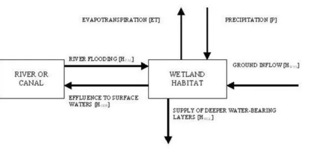
2.1.1. Wetlands as a component of the water circulation in the basin ... 122
2.1.2. Water balance of wetland habitats ... 123
2.1.3. Wetlands in the plans of the water management of reception basins ... 124
3. References ... 127
A tananyag a TÁMOP-4.1.2-08/1/A-2009-0032 pályázat keretében készült el.
A projekt az Európai Unió támogatásával, az Európai Regionális Fejlesztési Alap társfinanszírozásával valósult meg.
1. fejezet - Chapter 1. Water and water management
1. Lesson 1.
1.1. Water cycle in nature
The water cycle in nature (Figure 1) is driven by the Sun. Solar radiation causes evaporation of water, primarily from oceans. Water vapours are transformed into clouds, and water falls back as rain or snow. A portion of water flows underneath the ground surface, and another portion evaporates from ground, water or snow surfaces, or transpires through plants. The rest infiltrates into the ground and can reach even the groundwater table. Groundwater flows from higher elevations towards valleys and penetrates the surface in a form of springs, riverbeds or seas, or is drained by means of artificial interventions.
1.2. Water balance
The water cycle can be quantitatively expressed by the water balance equation. The Earth‟s water cycle is closed, without any gains or losses. A long-term water regime balance of continents is expressed by the following equation
precipitation = runoff + evaporation
In the water management, determination of the water regime of a river basin or an administrative or geographical unit is often relevant. For observation of a closed catchment area over a certain time interval, the water regime equation has the following form:
hN = hA + hV S
hN [mm] precipitation height hA [mm] runoff height hV [mm] evaporation height
S [mm] supply (retention) change
The values are considered as mean values for the same projection of an area and apply to the same time interval.
1.3. Components and sub-processes of surface stage of water cycle in nature
One of the most complex problems of hydrology is modelling the surface stage of the water cycle in nature.
Particularly striking is the ecosystem‟s vertical structure and complexity.
1.4. Precipitation
1.4.1. Precipitation measurement
Point measurement methods
The precipitation height for a short period of time is measured by precipitation gauges (rain gauges), and for a longer period of time by means of collection vessels (totallisers). Except regions at high altitudes and with large amounts of precipitation and snow, a device commonly used in Germany is HELLMANN precipitation/rain gauge (Figure 2). The area covered by this gauge is 200 cm2, and the collection vessel‟s capacity is 1.2 l to 1.4 l; the gauge is normally placed at a height of 1m above the ground surface.
The working principle of the Hellmann gauge (sampling area 200cm2, measurement height 1m above the ground surface) is based on a float. Precipitation water flows from the collection vessel into a metal cylinder containing the floating object. The float is fitted with a spindle to which a recording pen is attached which records the water height onto a registration drum. When the height of water corresponding to the precipitation height of 10mm is achieved, the metal cylinder is emptied by means of a siphon system and the precipitation water is drained into the collection vessel (Figure 2).
Measurement errors occurring with point measurement methods are caused by effects of wind which reduce the amount of precipitation entering the collection vessel, losses due to water trapped on walls of the collection funnel which also reduce the aggregate amount of precipitation, and minor losses due to evaporation from the collection vessel.
1.4.2. Remote precipitation measurement survey methods
Remote survey methods are used to make records of area precipitation which is relevant in terms for hydrology, with a spatial resolution level that can hardly be achieved with point measurement methods, given the large spatial variability of precipitation.
Remote survey methods are indirect precipitation measurement methods involving radar and satellite precipitation measuring.
A radar (Radio Detecting and Ranging) device uses the fact that water droplets reflect radiation within a microwave range. A radar device serves as a radiation transmitter and receiver of the reflected energy. The intensity of the received signal enables determination of the amount of precipitation across the observed area, with a time lag corresponding to the location's distance from the radar.
Satellite precipitation measurements are delivered by geo-stationary satellites or satellites orbiting over the Poles along elliptical paths at a height of approx. 900km. Unlike these satellites, geo-stationary satellites move at the Earth‟s orbital speed, and therefore stay over the same Earth‟s point at a height of approx. 36,000km.
Precipitation amounts and periods may be estimated pursuant to the type, thickness, surface temperature and size of clouds by means of various empirical methods. Satellite data are particularly important in areas where no terrestrial measurement stations are available, as well as over oceans.
The above described remote survey method entails a disadvantage in that terrestrial observations require calibration.
Areal precipitation
Below we discuss the most frequent areal precipitation determination methods.
Arithmetical mean
This method is suitable for use only for flat areas, longer time intervals (months, years) and an even spread of precipitation measurement locations. The method is based on the below equation:
hN [mm] areal precipitation
[mm] precipitation height at station i m [ - ] number of stations employed
1.4.3. Thiessen polygon method (nearest neighbour)
With this method, the examined area is partitioned and each catchment area‟s point is assigned the precipitation of the appropriate nearest station (“the nearest neighbour”). Values measured at the stations are interconnected by thin lines; then, central perpendiculars to these lines are drawn, which create a polygon around each station (sample area) (Figure 3).
The following equation applies to areal precipitation:
hN [mm] areal precipitation Ci [-] significance of station i [mm] precipitation height of station i m [ - ] number of stations employed
and the following significance factors apply:
Ci [-] significance of station i Ai [km2] area pertaining to station i
1.4.4. Inversion-distance method
This objective method is based on an orthogonal raster grid put onto the reference area. The precipitation value of each raster point can be determined from the appropriate surrounding stations. The most frequent method is the quadrant method. With this method, basic coordinate lines with the north-south and east-west orientation are drawn at each raster point within the area. The precipitation height of a raster point is computed from the four closest precipitation measurement stations of the reference points located in each of the four quadrants:
hN,j [mm] precipitation height of raster point j Ci,j [-] significance of raster point j vis-à-vis station i [mm] precipitation height of station i
where significances Ci,j mean appropriate relative reciprocal quadratic distances between each of the four precipitation measurement stations and a raster point:
Ci,j [-] significance of raster point j vis-à-vis station i di,j [m] distance between station i and raster point j Thus, areal precipitation is computed as:
hN [mm] areal precipitation
hN,j [mm] precipitation height of raster point j m [-] number of raster points
1.4.5. Isohyetal method
Isohyetal lines (isohyets) joining equal precipitation heights are interpolated from precipitation of neighbouring stations in proportion to their distances. Areal precipitation is determined by the following equation
hN [mm] areal precipitation
Ci [-] weighted share of isohyetal area i hI,i [mm] precipitation of isohyetal area i m [-] number of isohyetal areas
This method has an advantage in that it enables reflection of known factors affecting the spatial distribution of precipitation, e.g. orographic factors or terrain-related factors, in the isohyetal line design. In the past, the method was primarily used for representation of mean precipitation distributions over a number of years.
1.4.6. Geo-statistical methods
Compared to the previously mentioned common methods, geo-statistical methods have an advantage in that they enable reflection of characteristics of the area in question and the various precipitation events in the interpolation exercise. This reflection is done by means of a 'variogram' which represents the spatial variability of an examined variable. This facilitates the determination of significances Ci according to the precipitation variability, while with the Thiessen polygon method or the inversion-distance method these significances depend only on the measurement grid, and therefore remain constant for different events. Furthermore, geo- statistical methods predict errors in estimates for unknown points that are to be interpolated, and therefore are particularly suitable for the measurement grid planning.
One frequently used geo-statistical method is the Kriging method. With this method, precipitation at unknown points is computed through linear combinations of significant surrounding measured values. Weights of measured values are determined with a view to obtaining estimates which are free of distortion and best in terms of minimised error square sums. The Kriging method is an exact extrapolation method with which estimates at measurement points exactly correspond to measured values.
1.5. Snow
The snow cover is normally described by the following measurement parameters: snow depth d, which is measured by a snow stake; specific weight of snow rs, i.e. weight of snow per unit of volume; water content hN,W
(amount of water contained in the snow cover in a form of water or ice), also referred to as water value (value in mm above the horizontal surface); duration of snow cover, i.e. the number of days of a year during which the snow cover is present (important for thermoregulation). The water value hN,W [mm] is computed as
hN,W = rs d
rs [kgdm-3; 1kgdm-3 = 10mm of water per cm of snow]
d [cm]
The water content can be computed by means of energy balance of the snow cover indicating the amount of energy needed for the ice crystal melt. However, the energy balance computation requires extensive measurement data, including temperatures, moist, wind, solar radiation and distribution of temperatures across
the snow cover, which are normally not available. Therefore, simplified thermoregulation methods are applied in practice, such as the degree-day method. The following equation applies to the amount (runoff) of water from the snow cover G [mm d-1]:
G = ki (Ta – T0)
ki [mm°Cd-1] degree-day factor Ta [°C] daily mean air temperature
T0 [°C] air temperature at transition from snow to rain
1.6. Evaporation
As a part of the water cycle in nature, evaporation together with precipitation interlinks the separate Earth‟s water reservoirs (oceans-atmosphere-land). Evaporation is expressed as height (evaporation height hV) in mm, related to a reference period of time of even distribution of the evaporated water layer.
Evaporation occurs during precipitation, before rain falls onto the ground or its vegetation cover. The following types of evaporation are distinguished:
• evaporation
• interception
• transpiration
Evapotranspiration refers to the aggregate of evaporation and transpiration.
Evaporation refers to evaporation from exposed water surfaces, vegetation-free land, and water vapours caught by plants. It depends on the following meteorological conditions: air saturation deficit, air temperature, air movements and heat radiation from ground.
1.7. Interception
Interception means a type of precipitation which is retained by plant surfaces and evaporated without reaching the ground surface. Interception is affected by various factors:
• Meteorological parameters: duration, height, intensity and temporal distribution of precipitation; wind; solar radiation; potential evaporation intensity;
• Properties of vegetation: types of wooden plants or vegetation; age; rate of canopy closure; development over the seasons of the year.
The interception process is participated by all forms of vegetation. For forests, coniferous trees in general have higher interception effects than leafy trees. On average, spruces consume approx. 1/3 of annual precipitation through interception, while agricultural vegetation only 6% to 12% of annual precipitation.
Interception is measured by comparisons between measurements done under a vegetation canopy and on exposed ground.
1.8. Transpiration
Transpiration is the process by which vapour is emitted to the air by plants as a result of their metabolism.
Transpiration is subject to the same factors as evaporation. Furthermore, the type of plants, location, season of the year, and properties of soil are taken in account.
Determination of transpiration as an isolated parameter is hardly possible, and therefore it is generally measured only in combination with evaporation.
1.9. Relative evaporation and actual evaporation
In order to facilitate separate observation of atmospheric phenomena, the hypothetic concept of potential evaporation hV,p has been introduced. This term is defined as the maximum possible evaporation height in a single location or landscape area at given meteorological conditions, subject to availability of an optimum amount of water.
Actual evaporation hV,r is the evaporation height occurring in a single location or a landscape area at given meteorological conditions and the actual currently available amount of water. Due to insufficient availability of moisture, in many areas actual evaporation is often lower than potential evaporation. The equation hV,p = hV,r
applies only if an optimum amount of water is available.
1.10. Evaporation measurements
Evaporation may be measured in a single location (point) by means of water balance methods. Alternatively, it can be derived from the water balance maintenance equation, provided that all other terms have been determined.
An evaporimeter (evaporation gauge) measures evaporation values of surfaces which are permanently maintained in a moist condition (filtration paper, or ceramic discs), or by means of open evaporation vessels filled with water, where the water loss is measured by the change in the vessel‟s water level. However, the best way of measuring evaporation is by means of lysimeters (Figure 4). Lysimeters are natural areas covered by vegetation with a surface of at least 1 km2 and depth of 1 to 2m. They are jacketed, which means that seepage water may be collected and measured in the same way as precipitation.
Potential evaporation is determined by means of a simple balance equation, provided that the jacketed soil is maintained in a sufficiently moist condition e.g. by artificial raining. If a lysimeter determines the change in soil‟s moisture by weighing, the current evaporation height hV [mm] is defined by the following formula:
hN [mm] precipitation height
hA,u [mm] ground runoff height (seepage)
S [mm] change in vessel‟s level
Lysimeters enable, within certain limits, projection of the evaporation height onto other locations and larger areas.
The last evaporation measurement methods are the vapour current method and the energy balance method. The former method allows representation of the evaporation height hV [mm] according to the aerodynamic profile method based on a diffusion model as a product of the exchange coefficient for vapour AW [kg m-1s-1] and the vertical gradient of relative air humidity:
u [%] relative air humidity z [m] geodetic height
The exchange coefficient can be determined pursuant to the vertical gradient of wind velocity. Both wind velocity and relative air humidity must be known at the highest temporal resolution.
With the energy balance method, evaporation is treated as a thermal balance component.
1.11. Computation of areal evaporation
Areal evaporation is the emission of water from certain area into the air. This is not a measurable parameter. A number of evaporation computation methods are available, distinguished by examined type of evaporation, number of contemplated determining factors, and required resolution. Methods applied in Germany are stipulated in Ordinance 238 DVWK (DVWK, 1996).
1.12. Potential evaporation computation
By means of an example we describe the equation of the frequently used Penman method, where aerodynamic conditions and components of solar radiation are combined. They are applied to relations which are derived empirically, meaning that the determination of potential evaporation hV,p [mm] relies on commonly available climatic data. The equation is as follows: :
ws [-] significance factor of solar radiation RB [mm d-1] solar radiation balance
t [d] number of days for which computation is made vW [m s-1] mean daily wind velocity
pD,S [Pa] saturated vapour pressure as per equation (2.15 ) p [Pa] current vapour pressure as per equation (2.16 )
tL [°C] air temperature u [%] relative air humidity
1.13. Actual evaporation computation
Actual evaporation hV,r [mm] is often determined through reduction in potential evaporation:
-] reduction factor
hV,p [mm] potential evaporation height
models of basins which jointly simulate maintenance of the water balance in soil often yield hV,p as the output value, which is reduced according to the available water in soil to actual evaporation ratio. The Haude method offers a simple way to determining actual evaporation. The formula relies on a single measurement per day (14:00 o‟clock). This has been applied primarily in the artificial irrigation of fields by sprinkling. The Haude formula is valid only in temporal, humid climatic regions:
hV,r [mm] actual evaporation height fH [mmPa-1d-1] Haude factor
pD,S [Pa] saturated vapour pressure as per equation (2.15 ) pD [Pa] current vapour pressure as per equation (2.16 ) t [d] number of days for which computation is made.
2. Lesson 2.
2.1. Infiltration
Infiltration as a component of the water cycle plays a central role in the distribution of precipitation between surface water and groundwater; it reduces and delays the runoff portion, supplies necessary moist to soil for vegetation, and contributes to the increase in groundwater supplies. Intensity of infiltration is expressed as water height in mm per unit of time.
Excessive water which is unable of draining or precipitation infiltrate with a sharply formed and closed water front. A portion of water is retained, and therefore forces keeping water in pores decrease and the infiltration rate drops. During the infiltration process in soil with clear microstructure, three zones are formed.
The saturation zone is a thin layer which is saturated due to precipitation or flooding. The next zone is the soil reservoir zone, which is exposed to further wetting, and therefore becomes a transport zone. In addition to the gravitation potential, the force keeping water in soil pores in the wet front has such soil matrix potential, which facilitates vertical movement of the wet front.
However, the actual infiltration process is strongly co-determined by the macro-pore system. Macro-pores are long, mostly vertical cavities formed by vegetation roots, zooedaphone, as well as mechanical and thermal loads.
The amount of infiltrated water depends on both properties of precipitation and properties of soil and its vegetation.
2.2. Measurement methods
Infiltration and seepage through soil masses may be computed from measurement data obtained by weight- recordable lysimeters. Another alternative is measuring these two values by a double-circuit infiltration gauge.
The infiltration rate is established from the velocity of water level drop in the inner circuit. Water is used for wetting areas of measurement and suppressing errors due to side infiltration. For larger areas, seepage through the top soil layer may be determined by measuring water flowing out from a drain.
The water content can be established by means of a number of devices. The working principle of a Time- Domain-Reflectometer (TDR) is based on the fact that mixed ground-air-water dielectricity is dominated by dielectric constant water. Therefore, the TDR device determines dielectric constant values through the propagation velocity of a voltage jump on two parallel conductive bars in soil. Thus, water content in the dielectricum between the conductive bars in volume per-cent is estimated.
Another classical gauge used to determine the water content is a neutron probe which can be used for direct measurement of a change in the water content in soil. Neutrons are emitted by a source of radiation present in the probe‟s measurement part. Fast neutrons thus emitted are diffused and decelerated by hydrogen atoms of soil water. A portion of these decelerated neutrons is registered by the probe‟s measurement (counting) tube and converted into electric impulses. The number of impulses can be deemed to be the water content value.
2.3. Characteristic parameters
The essential property of soil in terms of hydrology is its capacity to retain water on the one hand, and drain water on the other hand. A number of different special parameters of soil are applied in practice in order to characterise water contents. The following can be distinguished:
• Gravitational water which penetrates larger pores due to effects of gravitation, and thus gives rise to new groundwater.
• Capillary water which is retained in medium-size pores due to effects of surface tensions and adsorption forces.
• Adsorption water which is tightly bound onto particle surfaces as water film due to the hydrating and electrostatic effects. The maximum thickness of such film is 20 molecule layers.
The following parameters area required in practical hydrological applications in order to determine the water content characteristic: porosity, degree of saturation, field capacity and wilting point.
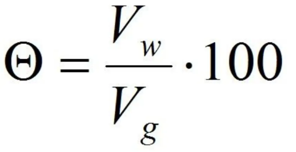
Porosity n [Vol.-%] is defined as the quotient between volume of cavities Vp [cm3] and total volume Vg [cm3]:
In addition to the absolute porosity value, the movement of water in soil is also determined by pore sizes and the secondary pore system.
-%] is the ratio of water content Vw [cm3], which can be received from a soil sample by drying at 105°C, to the total volume of the sample Vg [cm3]:
The degree of saturation s [-] is the water content to porosity ratio:
Field capacity FK [Vol.-%] is the amount of water which soil is able to retain against the gravity without affecting evapotranspiration over a longer period of time. Since values are obtained from different locations and therefore are not quite comparable, a moisture equivalent FÄ [Vol.-%] as a laboratory parameter has been introduced. The moisture equivalent defines the amount of water which remains in soil after the soil has been drained by vacuum of a magnitude depending on the type of soil.
The minimum water content at which, if not achieved, a plant irreversibly wilts is referred to as permanent wilting point PWP [Vol.-%]. Again, these values are not comparable due to involvement of a too big number of different factors, and therefore an equivalent wilting point EPW [Vol.-%] has been introduced, which indicates the water content which remains in soil after the soil has been drained by vacuum of 1.5Mpa.
2.4. Relation between absorption tension and saturation
Absorption tension is a parameter defining the intensity of water formation in soil and depends on the water content. The relation between absorption tension and saturation, or the water retention capacity curve can be obtained by representing the absorption tension or matrix potential as a function of the water content of soil. The curve clearly indicates what water content will remain in soil after draining at certain absorption tension.
Figure 5 shows curves for different types of soil, together with some explaining water formation parameters. By comparing curves of various types of soil we can see that fine-grained soils (such as clay) may accumulate a significantly higher amount of water than coarse-grained soils (such as sand), however, they also need significantly higher tension to drain off. This is because fine-grained soils have a larger water/soil surface and therefore their adsorption forces are higher but, on the other hand, the diameter of pores is lesser. However, compared to large pores, small pores drain off only at significantly higher vacuum magnitudes. This clearly indicates that the relation between absorption tension and saturation reflects the pore size distribution.
2.5. Groundwater
In a groundwater system (Fig. 6) the groundwater surface is the upper boundary separating the groundwater area from the aeration area lying over it. If air pressure is present there, the groundwater surface and groundwater are referred to as unconfined. The groundwater table, or the summation of the geodetic height and the piezometric height for a point of the examined groundwater body in an observation tube, indicates the groundwater surface level only if no major vertical movements occur in the tube.
If an impermeable stratum covers the rock stratum that drains water (aquifier) and water inflow from higher strata is present, then the pressure on the groundwater surface is higher than the pressure of the surrounding air.
In such case, the groundwater is groundwater with tension and the aggregate of all summations of geodetic heights and piezometric heights for a point of the examined groundwater body (water level heights in observation tubes) equals to the piezometric surface of the groundwater.
In order to enable measurement of groundwater storage and its temporal fluctuations, the groundwater stage is examined in groundwater measurement locations (observation wells, groundwater levels). The groundwater stage is the distance of the groundwater table between a single location of measurement and a measurement point, which is mostly the upper edge of a tube or well. Periodical measurements are done by means of instruments emitting acoustic or optic signal upon reaching the groundwater level. Measured values of each point of measurement are recorded in a form of a hydrograph, or in case of larger areas of groundwater contour lines.
2.6. Groundwater dynamics
Examination of underground water flows requires differentiation between a number of velocity concepts, since water may not flow across the entire cross-sectional area, but only through a porous area interconnected by longer sections.
Flow velocity of the entire cross-sectional area, computed as a quotient of the flow rate and the cross-sectional area size, yields so called filtration velocity or Darcy velocity vf [m s-1]
kf [ms-1] hydraulic conductivity at water saturation Ist [mm-1] water-level gradient in the observation tube
In the equation (2.22), the declining gradient is defined as a negative number, though the flow velocity always points towards the declining gradient direction.
The equation (2.22) applies only in the specific case of one-dimensional filtration flow at full saturation with water. The general case of three-dimensional flow at both saturated and non-saturated conditions is described by the basic dynamic equation
Vf [ms-1] filtration velocity vector
kf -1] hydraulic conductivity depending on the water content tial
Hydraulic conductivity or permeability kf -1] is computed as a function of the water content according to the below formula:
kf [m s-1] hydraulic conductivity at saturation with water -%] water content
0 [Vol.-%] residual water content, if kf = 0 n [Vol.-%] porosity
-] significance factor; here often = 3
s z = 0 on the groundwater surface
z [m] geodetic height p [Pa] pressure
w [kgm-3] specific weight of water g [ms-2] gravitational acceleration.
2.7. Formation of new groundwater
The major contributor to the formation of new groundwater is precipitation water penetrating into the ground by infiltration, and seeping into groundwater. The new groundwater formation rate (gain) is the amount of groundwater seeping into groundwater per unit of time. The new groundwater formation rate (gain) can be determined with a fair accuracy from balance computations. As the average amount of groundwater over a number of years equals to new water formation, the following equation applies to larger enclosed catchment areas:
GWN = hN - hV - hA
GWN [mm] new groundwater formation hN [mm] precipitation height
hV [mm] evaporation height hA [mm] runoff height
2.8. Runoff
A model of three runoff components relies on a vertically structured soil system: surface runoff comprising runoffs above the upper surface edge; interflow consisting of runoff originating in ground strata located close to the surface or the bottom vegetation zone; and groundwater runoff formed by groundwater. Direct runoff consists of fast components of surface runoff and the fast portion of interflow. The portion of precipitation contributing to direct runoff is referred to as actual precipitation. Base runoff is composed of slow components of interflow and groundwater runoff.
In practice, specific runoff q is normally expressed as q [m3s-1km-2] and is defined as the quotient between runoff rate QA [m3s-1] of a certain channel (drain) point and the appropriate catchment area size AE [km2]:
3. Topic related questions
1.What are the two main fields of meteorology?
• a.0 statistical meteorology and deterministic meteorology
• b.1 dynamic and synoptic meteorology
• c.0 theoretical meteorology and practical meteorology 2.Climatology studies:
• a.1 the average condition of the atmosphere in a single location
• b.0 processes occurring in the strata of the Earth‟s atmosphere
• c. 0 physical, chemical, geological and biological processes in world‟s seas
3.Atmosphere
• a. 1 consists primarily of nitrogen and oxygen
• b.0 does not contain any nitrogen
• c.0 consists primarily of carbon dioxide 4.Precipitation and evaporation depend on
• a.1 the water content in air
• b.0 the sea tide and ebb
• c.0 snow cover
5.In terms of size, mesoclimate relates to an area covering
• a.0 several kilometres
• b.0 a continent
• c.1 several hundreds of kilometres
6.The highest precipitation rates have been recorded in
• a.1 the equatorial zone?
• b.0 polar regions?
• c.0 the temporal climatic zone?
7.Condensation refers to
• a.1 the transition of a substance from the gaseous state to the liquid state
• b.0 the transition of a substance from the liquid state to the gaseous state
• c.0 the transition of a substance from the solid state to the liquid state 8.Thunderstorms are
• a.0 orographic precipitation
• b.0 frontal precipitation
• c.1 convective precipitation
9.Global Circulation Models are used for
• a.1 simulation of hypothetic development of the climate change
• b.0 modelling the formation of precipitation
• c.0 simulation of the transformation of precipitation to runoff 10.Precipitation
• a.0 has no temporal variability
• b.1 varies as a function of latitude
• c.0 remains constant across the entire land
11.Concentration of runoff is understood as
• a.0the relation between precipitation within a watercourse‟s catchment area and he amount of runoff at the area‟s discharge.
• b.1translation of actual precipitation into a hydrograph of direct runoff from a surface catchment area.
• c.0the ratio between an actual precipitation height hN,e and a precipitation height hN
2. fejezet - Chapter 2.
1. Lesson 1.
1.1. Sustainable Water Management
We will know actual value of water when our wells will dry up. Benjamin Franklin, (1706-1790), Poor Richard's Almanac, 1746
These words characterize - much more than long and descriptive publications, articles or presentations - our relation to water which has not changed very much for last 250 years. We appreciate water value only when it is unavailable out of reason of dryness, bad quality or high price. In our territory it is just when we find out that its price has to be increased. This work should contribute to appreciation of water value in our daily life.
View of life quality, human demands and way of life is changing. Around the year 1900 when were built first public water-ducts in our territory, canalization was still rare and sewage tanks were only vision. People appreciated each new development of waterline or canalization. During last 100 years the situation in Slovakia as well as in other civilized countries has changed, but not in such scale as in the most developed countries of the Europe. It is necessary to build constantly new local resources in the form of wells or trapped springs for production of drinking water for provision of resources for new supplying of towns and villages. Where it is not possible, it is necessary to obtain water from surface resources. Population range has also changed significantly during last 100 years. With population increase water need has also risen.
With increasing water consumption also amounts of produced sewage water have risen. Man increasingly develops pressure on the nature. He needs more and more pure superior water for drinking and for other purposes. On the other hand he discharges into all waters - into surface or ground ones - more and more waste waters.
Waste materials are discharged into the waters that were utilized during millenniums only as drinking water or water for crop irrigation or water was simply the resource of mechanism drive and material transport; water becomes the place of disposal of liquid and some gentle solid wastes trapped for example from gaseous emissions. Change of water quality in our territory and also worldwide is very serious during last hundred years.
People have polluted not only water but also the atmosphere and the soil. Natural resources are increasingly influenced by human activity. The more resources are polluted the more people need these resources.
Many important personalities of the world have begun to meditate at the end of the 1980`s and in the beginning of the 1990`s on what may happen if we will go on to exploit the nature in this manner. Soon can happen that there will be no sufficiency of pure water. Thus after various stages of ecological struggles there was elaborated preparation of one of the most significant undertaking – the Conference in Rio de Janeiro in 1992. There have met leading scientists, politicians and experts of the whole world in order to say how to leave for future generations the nature where life will be possible.
New period has begun when was changed the opinion on natural resources on first place. The epoch of further development of humankind must be the period when it would be necessary to observe principles of sustainable development - development saving the resources. For this development it is necessary to adjust all our further activities.
Water protection as ground of life is first-rate aim of environmental policy of each state. Water is influenced by various activities. Economic growth must be focused on water management covering in accordance with the environment to meet its important functions in the nature circulation as well as in the landscape economy in the future.
Hydroeconomic exploitation protecting waters as well as man, above all against floods generally abides with following tasks and aims (Sander 1995):
1. Provision of balanced water balance on behalf of ecological balance of waters, from the nature and the landscape to satisfaction of requirements of water users.
2. Long-term qualitative and quantitative provision of water supply for population, agriculture, small and large firms, but in the framework of limited available amount so as surface and ground resources should not loaded exceedingly.
3. Elimination of irregular and limiting conditions of the development in the fields of insufficient water resources by supplying from other areas but under preservation of ecological conditions and development possibility in both areas.
4. Provision of suitable hydroeconomic areas, for public water supply preferentially.
5. Care for the nature state considering area water protection with controlled waste water drainage.
All possibilities for minimalization and prevention of waste water rise are in the first place. It is also necessary to ensure gradual elimination of rainfall water drainage into recipients without utilization or to support their soaking in the place of origin.
It is possible to achieve reduction of waste water production by various technological provisions in manufactural and converting plants or by personal approach towards utilization of drinking water in dwelling areas and in non-manufacturing institutions.
Global problems are issue of human survival worldwide. Their implementation can not be followed-up only from the worldwide view but it is necessary to implement them from basic parts of the world:
• individuals
• human groups
• towns and villages
• regions
• and particular states.
1.2. 2.1. Water Management in general
Water management is the field in which ecology and economics stand imminently along with utilization of renewable natural resource.
All consider water for renewable resource but also limited one which restores in quality and quantity, but which can be also damaged irretrievably. Sufficiency of water forms essential issues of existence whereby water is in the centre of consideration in solution to many tasks. Out of multifunctional water utilization result various requirements for its properties. Many functional properties of water were profiled according to these requirements based on incidence and utilizable amount in particular areas. Their importance increases with the resource decrease. Following historical development of requirements and water functions in the society water achieved many cultural and social properties and importance.
Water management is identified as basic scientific field which investigates hydroeconomic activities and above all is stimulated by actual or potential disproportion between the resources and water need for given purpose.
This disproportion must be understood very widely. It is presented not only by insufficient permanent or seasonal coverage of water requirements for satisfying of that are used utility properties of water in certain territory, but also that water resources exceed this requirement permanently or temporarily in undesirable measure and when man does not gain control of them, they cause large damages.
The definition of water management was formulated according to type of hydroeconomic activities. Based on large-scale analysis of international viewpoints has formulated the definition of water management generally as:
"Summary of manufacture activities that are realized in working processes which result in water as the product."
It is understanding of water only as raw material or production tool not as the nature component. Dominant element is still water for national economy and its utilization, but it is already based on knowledge of the nature and society relations.
Moreover it defines water management as science of interdisciplinary nature developing theoretical elements of complex management of water resources affecting interaction of natural, technical and social and economic processes.
• systematic human activity tending to the utilization, protection and development of water resources and to protection from harmful effects of waters (hydroeconomic activity),
• set of hydroeconomic activities,
• branch of national economy as set of organizations that have hydroeconomic activities as major scope.
It explains also the term water resource for proper understanding of first definition. Following listed standard it designates surface or ground water which is utilized or can be utilized in national economy for population requirements and for other purposes in general behalf.
Hydroeconomic activities include also protection and development of water resources. Here is manifested the phenomenon of water circulation in the nature which ensures renewal of water resources, however activities of the society can significantly modify or change conditions of this renewal. To protect water resource means not only to protect its quality, but also to protect also the space in which it originates (watershed, hydrologic structure) and to ensure conditions for desirable development of its quality. That means protection of surface, earth and ground waters that interact with protected resource. However neither the most consistent protection
need not meet the purpose; for example it may come to permanent air pollution as well as atmospheric water.
From this viewpoint it will be necessary to extend the protection on the whole hydrologic cycle that means to atmospheric water and water in the world ocean too.
Request for complex and rational utilization of water resources results above all from their limitation. Single- purpose waterworks built in the past are typical demonstration of extensive utilization of water resources. With increasing demand for water now are built all-purpose waterworks and they are interconnected into specific systems.
In comparison with before listed definitions there is remarkable movement from economic and social meaning of water to ecological meaning and to egality of all these meanings.
Encyclopedian interpretation specifies that water management is the branch of national economy and scientific and technical branch ensuring rational utilization of water resources for economic purposes and water protection as irretrievable natural wealth. According to this author to water management belong water supply, draining and purification of waste waters, agricultural meliorations, transportation, water energy utilization, protection from floods and fishpond cultivation.
In foreign literature is very known the definition presented in the publication issued in 10th edition of
„Taschenbuch der Wasserwirtschaft“ (Bretschneider 1993) elaborated by composite author. In the section Hydroeconomic Planning author of this section Gert. A. Schults bestows to water management following meaning:
Water management includes distribution of naturally occurring water in time and space following requirements of the society according to quantity and quality of water. It comes to provisions under water utilization (for example for purposes of drinking water, irrigations, water energy) or protection from water (for example from floods, soil soaking, etc.).
Herewith issues of water balance and amount in water management as well as issues of water quality and also issues of water morphology are included in water management.
Water management as discipline is young formation which develops swiftly. From this viewpoint it is necessaty to understand water management as set of knowledge, methods and proceedings that enable to study and to solve the relations and mutual influencing of natural processes running in part of hydrosphere and social processes relating to water component in particular region. There are intersected proceedings and methods of natural sciences, technical solutions with ecological and economic aspects, that all in real conditions. Therefore also methods used in scientific solution to the problems of water management are very different and their jointing in effort of complex description and problem solution meets with considerable difficulties and is subject of further research.
2. Lesson 2.
2.1. Tasks and Aims of Water Management
Tasks and aims of water management are changing and developing with human society development.
Formerly it was mainly provision of water sufficiency for people for drinking and personal consumption and for farm crop irrigations. Gradually it was utilization for ship transportation, source of mechanical and later of electric energy, etc.
With mankind development the aims and tasks gradually expanded, changed and their importance was revaluated.
Nowadays they generally take into account water importance as first. Essential water importance following Kleeberg (1998) may be summarized as:
• Water is concurrently life source and raw material
• Water is one of the most important resources of natural raw materials
• Water plays in the nature the most important role
• Water in its time and space distribution determines conditions of life for people, animals, plants
• Water determines utilization of the landscape, regions
• Water creates the scene, i. e. water is factor of the landscape formation
• Water is part of cultural heritage as well as religious customs and traditions
If we would actually transfer the definition of sustainable development by Brundtland into the conditions of water management it should be interpreted that water as natural resource can be utilized only in such scale that waters (seas, rivers, lakes, ground water) will be preserved for future generations in the same quality and quantity. But these visions are today enforced only in the case of drinking water resources. Requirement of integrated covering and planning of water resource utilization is listed inter alia in chapter 17 in Agenda 21 particularly.
As sustainable water management is designated integrated covering of all artificial and natural water circulations under consideration of three essential aims:
• Long-term protection of water as the environment or as central element of our environment
• Water provision in its various forms as the resource for present as well as for future generations
• Accessing preferred rights for sustainable natural, economic and social development.
In the course of this definition were elaborated principles of sustainable water management after evaluation of the discussions by participants of the symposium „Nachhaltige Wasserwirtschaft“ in Bonn. There are generally nine principles. Because of their extensiveness we present only brief review:
Principle of regionality – it requires so as each region has the conception of hydroeconomic economy with own water resources. Their solution should not influence surrounding regions. It is mainly prevention from threat of foreign resources of drinking water regarding their quality or quantity. Main aim is therefore active recovery of own resources and achieving their original state and efficiency.
Finally the aim of principle of generation connection is that at least effects on future generations to be taken into account at any decision making or at provision that have to be adopted in the field of water management. But time horizon of the solution effect influences also the scope of responsibility for future generations. Whereas for example dams, water-gates and other water structures are built for more than 100 years, their impact on future generations is significant.
Principle of causality – costs for pollution and utilization of the resources must bear those who caused them.
Natural catastrophes jeopardizing waters in many cases were not compensated by floods, neither partially nor at all. Instead of these agents the state or special funds often must bear costs for damages in the regions or also abroad. It is not clear how to recompensate future generations for loss of many water resources that are permanently contamined and water must be brought into the territory from other remote regions, of course with much more costs. Assigning of damages to the agent helps to enhance handling with waters qualitatively as well as quantitatively.
Principle of cooperation and participation – in all hydroeconomic decisions must be adequately considered all interests. It is necessary to support the possibility of independent organization and effect in hydroeconomic provisions. The principle of cooperation and participation requires foremost the possibility of democratic control, mainly on local level. Resulting aim is to achieve general control in hydroeconomic decisions. Part of decision rights is transferred to people groups that may contribute to effective decisions. Thus the task is not only "strong" parties participate on the planning, but also other interested parties that share on practical implementation of water utilization or on their protection.
Principle of resource minimalization – it is necessary constantly and continually restrict direct and indirect water resources and energy consumption. Aim of the principle of resource minimalization is not only ensuring suitable utilization of water resources but also providing restriction of waste water rise. Content of waste materials in these waters causes increased need of further energy or material inputs for their removal.
Principle of preliminary care – In the principle of preliminary care must be taken into account all potential influences that should cause significant threats, even when their incidence probability is very low or cannot be
estimated. This principle is extraordinary serious. Only if we want to prevent from nameless risks we can ensure safe conditions also for future generations. Above all it is important in determination of hazardous substances that should not penetrate into waters because recently are no natural purification processes in the nature for these substances. Nevertheless amounts of unknown substances penetrate into waters and we have neither analytical methods for evaluation of their incidence nor determination by any regulation. But their cumulative effect in the ecosystems may eventually cause menace of live organisms.
Principle of reduction of pollution sources – It is necessary to catch most serious forms of pollution already in the place of their origin (not on „end of pipe“) while they are reconstituted only in small amounts of water. After reconstitution and mixing with substances and with waters from other sources of pollution their removal is uncertain and often very expensive. Therefore these principles are almost in total conflict with common sewage network where rainfall waters are mixed with substances in waste waters.
Principle of reversibility – Following principle of reversibility all hydroeconomic provisions should be executed accordingly their effect that could be returned into original state when eventually was found that their impact has been negative. Moreover it is required that potential adjustment of provision for changed conditions should be figured in the provision draft in advance. It is requirement for future generations to amend current clear definite decisions. For example in drafting current constructions it is important to consider also requirements of influenced species and their biotopes. Destruction of species biotope leads of course to the species extinction, too.
Principle of integration – hydroeconomic plans and decisions must in their time horizont match to the time horizon of their effect, duration respectively. For solution to the principle of integration the water what we utilize in various variations of using must be understood as one element, essential element of the nature. It is then utilized as one element. Water utilization was registered in social sections in past years. Negative demonstrations of excessive utilization in one section led to the problems in other utilization areas. For example straightening of channel streams for canalization enhancement can lead to threat in flood flowages.
In discussion on tasks of sustainable water management in comparison with current state of water management it is necessary to discuss and solve following fields (Rudolph 2000):
• Issue of pollutants - for sustainable water management it is required that loading of waters by substances and organisms should not exceed their natural purification capacity.
• Issues of control of water resources – besides rapidly renewable resources are used also other resources for water supply and drainage of waste waters – e.g. energy, raw materials and other substances. Within sustainable development should be used only renewable resources. Requirements must not exceed rate of the resource regeneration.
• Economic issues – within the framework of water management it is necessary to take into account also external costs for the environment. Water price for enterprises and population should be balanced concurrently.
• Development of new strategies for sanitary devices – to achieve sustainability of water management it is necessary to use new technologies of enhanced utilization of resources for rational utilization of water.
• New region (space) oriented strategies of surface and ground water protection – concerning sustainable water management it is required to utilize only resources from exactly defined area for certain supplied territory. It is necessary for achieving of regional sustainable development.
Since the end of the 1990`s are used balance and amount (material) models as basis for the resource utilization management in water management as well as in other fields. Not only water in its quality and quantity is followed but also very exactly concurrent resources, for example materials and energies used for construction and operation of waterworks and sewage facilities as well as balance of substances transported by water, for example nutritious substances, trace elements or harmful materials.
3. List of references
• Bretschneider H. akol,1993. Taschenbuch der Wasserwirtschaft, Parey Verlag, 8.
• Kleeberg, H.B., Lobhler, S., Dick, T.,1998. Wasserwirtschaft und Wasserbau in ländlichen Raum, Universität der Bundeswehr, München, 1998
• Rudolph, K.-U., 2000. Nachhaltige Wasserwirtschaft, Technische Universität Harburg, 2000.
• Sander, R.,1995. Wasserwirtschaftspolitik in der Kommunen – Ansätze fűr eine nachhaltige Entwicklung.
Deutsches Institut fűr Urbanistik, Berlin, 1995
4. The Hungarian experince in combating nutrient run-
off from rural areas (Figure 32-71)
3. fejezet - Chapter 3. Watercourses
1. Lesson 1.
1.1. Classification of watercourses
Watercourse beds may be created by a natural process or artificially (channel). From this perspective, watercourses are classified into natural and artificial. Under conditions prevailing in our country, hydrologic significance and ecologic significance of natural streams prevail over those of artificial waterways. However, they are in higher risk at flood wave passages. Thus, a majority of river sections within developed areas of towns and municipalities is regulated by alteration of the riverbed‟s shape and flow capacity in order to facilitate conveyance of the maximum projected flow rate.
From a short-tem perspective, water streams are very volatile systems. Many of their parameters fluctuate on a regular or irregular basis. Naturally, such fluctuations, often rather sudden, largely affect properties of the flow.
Riverbed rerouting and flooding are natural features of a water stream.
One characteristic of flowing streams is unidirectional water flow. Flowing water forms drainage systems over the entire earth‟s surface, consisting of creeks and rivers. The nature of flowing waters between the spring and the mouth into another river or sea is very manifold. Force of the unidirectional flow as typical feature of flowing streams depends on primarily on the gradient. The water flow constantly conveys and removes solved and suspended substances and deposits them in other locations. Flowing streams are a part of river systems enabling spread of organisms. From the spring to the mouth, a river flow gradually extends its width and depth, the temperature rises, as does the scope of annual fluctuation, while the gradient drops.
1.2. General classification of water streams
Surface streams are generally classified into torrents, mountain creeks, creeks, rivers and large rivers.
Torrents are mountainous streams, either independent or as mountainous sections of longer streams, characterised by great and irregular longitudinal gradients, irregular flow directions and irregular cross sections and bottoms. The bed is usually deeply incised into the terrain, and the bottom is made up of large rocks creating natural cross-sectional impediments; spills, cascades and sills are formed. Torrents are normally characterised by significant movement of fluvial sediments and sudden flow rate fluctuations. Different torrents have different properties depending on their type, origin and the quantity of fluvial sediments, determined by geological and pedologic conditions prevailing in the pertaining catchment area.
A torrent area is composed by three main zones:
1. drainage area (torrent perimeter), i.e. the runoff area normally identical to the precipitation catchment area;
2. torrent bed (transport area) within which masses of materials are conveyed downstream;
3. debris cone (torrent, dejection) where such conveyed materials are deposited.
Activity of torrents is very dangerous for both development of their own bed and follow up streams (usually mountain creeks) and streams into which torrents mouth (due to fluvial deposit gains) and adjacent areas.
Regulation of torrents, traditionally referred to as torrent impoundment, means not only regulation of the bed itself, but intervention in a broader catchment area, involving implementation of bio-technical measures to regulate and control the water passage and the water‟s erosive activity, and combat soil erosion and avalanches.
A torrent emanates from a spring located in the highest point of a river basin; its flow starts in the spring and ends in a certain point, from which stream continues to flow as mountain creek. This point is determined though specific research, with due consideration of specific features of the entire catchment area, such as gradient- related, geo-morphologic and economic conditions and the movement of fluvial sediments; this is normally irrelevant in non-torrent streams, as their regulation involves only modification of the bed itself, without improvement of retention capacities of the entire catchment area.
Mountain creeks, unlike torrents, are characterised by developed valleys, rather balanced bed bottom gradients with which the water flow neither takes on nor deposits fluvial sediments; but water levels are still subject to large fluctuations which may disturb the temporary saturation of the stream with fluvial sediments.
Creeks are minor streams with small catchment areas, more moderate and balanced longitudinal gradients of the bed and small drift of fluvial sediments. The span between extreme water levels is not as wide as in mountain creeks. However, they are dangerous at flood occurrences, since they can be effectively exposed to sudden snow melting or torrential rainfall, especially if these occur across the entire creek‟s catchment area. In its uppermost section, a creek typically has the nature of torrent with high flow velocity. When spilling over rocks or in waterfalls, the flow velocity may reach up to 6m.s-1. The lower velocity limit in lower sections of a creek is defined as 0.5 m.s-1. With this velocity, water is still able of conveying sand grains sized over 5mm.