ENVIRONMENTAL HISTORY OF THE CSORNA PLAIN (WESTERN DANUBE PLAIN, NW HUNGARY) FROM THE LATE GLACIAL TO
THE LATE HOLOCENE AS SEEN FROM DATA OF MULTIPROXY GEOARCHAEOLOGICAL INVESTIGATIONS
Tünde Törőcsik, Sándor Gulyás
*, Pál Sümegi, Balázs Sümegi, Dávid Molnár, Réka Benyó-Korcsmáros
Departament of Geology and Paleontology, University of Szeged, 2-6 Egyetem u., Szeged 6722, Hungary;
e-mails: t.torocsik@geo.u-szeged.hu; gulyas.sandor@geo.u-szeged.hu; sumegi@geo.u-szeged.hu;
b.p.sumegi@gmail.com; molnard@geo.u-szeged.hu
* corresponding author
Abstract:
This study presents the results of a comprehensive geoarchaeological study implemented at an archeological site cover- ing ca. 5 ha near the city of Csorna on the NW part of the Danube Plain, NW Hungary. The site itself exposed a complex fluvial system of an ice age creek with near bank and overbank areas (levee, point bar, back swamp). Spatial distribution of archeological features allowed for the interpretation of differential use of the fluvial landscape by different cultures.
According to our data, the referred fluvial system must have emerged during the Late Glacial. At this time, creeks orig- inating from hills to the SE followed a uniform NW trajectory. From the Holocene, small creeks were beheaded turning into inactive flood channels. It was the time when the gradual infilling of the floodplain started. Alternating layers of floodwater coarses and floodplain fines mark recurring floods at our site. These could have been correlated with cooler, wetter climatic phases of the North Atlantic, Western Europe and high stands in Central European lakes. Highest floods are recorded during the Late Bronze and Iron Ages besides the Neolithic. Pollen data enabled us to make inferences on the vegetation as well.
Key words: fluvial geoarchaeology, environmental history, flood cycles, Danube Plain, NW Hungary Manuscript received 10 December 2018, accepted 26 February 2019
INTRODUCTION
Rescue excavations along the Győr-Csorna 85 freeway have yielded numerous archeological features and arte- facts from the time of the Neolithic (Raczky, 2007) to the Ottoman Age (Nagy, 2012; Takács, 2008; Tomka, 1996, 2008a, b; Pesti, 2016). One of the studied sites near the city of Csorna known as Lórét with an excavated surface of 50,000 m2 has yielded the largest number of artefacts displaying a unique spatial pattern both vertically and hor- izontally. Vertically alternating layers with rich and no ar- cheology has been documented at the site. Nevertheless, features and artefacts discovered seem to cover the entire time frame from the Neolithic to the Middle Ages.
The uppermost archeological horizon yielded more than 1,800 features dated to the Early Middle Ages and the
Migration Age on an area of 51,000 m2. This was under- lain by a horizon completely void of archeology. The next dark grey settlement horizon covering an area of 11,000 m2 yielded 267 Neolithic and Bronze Age features. Probe maps have been prepared via geoarchaeological coring (Sümegi, 2001; Sümegi et al., 2012). In addition, the actual excavation was continuously monitored and sampled for geoarchaeolog- ical investigations from the start of the excavations (Sávai et al., 2015). This also enabled us to construct on-site geolog- ical profiles and discover ancient geological, hydrological features which would have gone unnoticed otherwise.
This study is about to present the findings of a complex multiproxy geoarchaeological study implemented on the ex- cavation site covering ca. 5 ha, ranging from geomorpho- logical studies to sedimentological, geochemical, paleoeco- logical investigations. A multidisciplinary evaluation of the
results yielded the most reliable paleoenvironmental and en- vironmental historical reconstruction for the area available so far from the time of the Pleniglacial to the Late Holocene.
LOCATION, GEOGRAPHICAL, CLIMATIC ENDOWMENTS OF THE STUDY SITE The study site is found at the southern fringe of the Danube Plain (Little Hungarian Plain) in the area of the so-called Csorna Plain (Fig. 1). The area itself is found in a relatively higher morphological position occupying a fossil alluvial fan (Ferenczi, 1924; Jaskó, 1935; Sümeghy, 1944;
Pécsi, 1959, 1962; Bendefy, 1977).
According to the literature, the geological evolution of the area was controlled by one of the largest tributaries of the Danube the Raab or Rába River having a total length of 283 km and a watershed area of 10,720 km2 (Sümeghy, 1944; Somogyi, 1961; Fodor et al., 2005; Lovász, 2007;
Gábris and Nádor, 2007; Zámoly et al., 2010). Using data on Quaternary fluvial deposit thickness and certain fos- sils low resolution reconstructions were made regarding
the fluvio-morphological evolution mostly focusing on the larger area of the Danube Plain (Jaskó, 1935; Sümeghy, 1944; Kordos and Krolopp, 1990). A relatively recent work pointed to the importance of differential subsidence of sub-basins in the Danube Plain as a major driver of land- scape evolution resulting in the beheading of creeks with a SE-NW flow from the Late Glacial and creating the mod- ern hydrological network (Sávai et al., 2015).
Today the area of the Csorna Plain is under intensive cultivation. As a result, both the natural vegetation and fauna as well as soils must have been altered following the 19th century drainage works and river regulations resulting the drainage of marshlands, lowering of the groundwater table, construction of roads, railways, irrigation and drain- age canals as well as the creation of extensive arable lands, pastures and orchards. Consequently, pre-industrial vegeta- tion, soils, and fauna could be potentially inferred from cli- matic parameters of the area alone (Szabó, 2005). Surface planation connected to crop farming created a relatively even surface in the Csorna Plain losing information on the original geomorphological endowments. These features can be studied only in cross-sections of rescue excavations
Fig. 1. Location (a), paleohydrological conditions preceding the 19th century river regulations (b) and geomorphology of the study site Csorna-Lórét (d) and its surroundings of the Danube Plain (c).
in connection with construction of road networks following the removal of the modern topsoil.
The modern climate of the area is Continental with milder winters and cooler summers than the central part of the Carpathian Basin. It is due to the stronger Oceanic Influences seen in the relatively high rate of annual pre- cipitation (540 mm), which can reach 650–700 mm as well (Hungarian Meteorological Survey). The average annual temperatures are also somewhat lower (10.3°C).
MATERIAL AND METHODS
The workflow and methodology of geoarchaeologi- cal investigations followed the protocol established for Geoarchaeological studies at the Department of Geology and Paleontology, University of Szeged, Hungary (Sümegi, 2001, 2002, 2003, 2013).
Geomorphological investigations
Drone-made aerial photographs of the Archeo Art Ltd.
taken at a lower (75 m) and higher (125 m) altitudes have been handed over for geomorphological evaluations (Pesti, 2016;
Sümegi, 2016). In addition, historical maps of the area have also been considered. The most important are the ones of the First (1782) and Second (1869) Austrian Military Surveys (Timár et al., 2006, 2011). Furthermore, the hydrological map of the Carpathian Basin preceding the 19th century river regulations have also been considered, as it gives a relatively reliable view of the distribution of permanently and tempo- rary inundated areas (Fig. 1). Finally, high resolution digital elevation models of the wider vicinity of the site have been prepared and analyzed (Sávai et al., 2015; Sümegi, 2016).
In the next part the several hundred-meter-long sec- tions at the archeological excavation site have been cleaned every 20 m yielding geological profiles, which were visu- ally described and photographed following the previously mentioned protocol (Sümegi, 2002, 2003). Position and elevation of the geological profiles as well as the identi- fied geological horizons have been recorded enabling the clarification of the original position of geomorphological units. The detailed on-site visual sedimentary facies and sequence analysis have clearly outlined a restricted dis- tribution of anthropogenic and cultural deposits confined mainly to small archeological features (pits, graves, wells, postholes) (Barham, 1995; Barham and Macphail, 2016).
Consequently, the settlement strategy and patterns of for- mer cultures as well as the remaining attesting cultural deposits were controlled by the geological, geomorpho- logical endowments of the site and its vicinity from the Late Glacial to the modern times (Bates and Bates, 2000;
Shackley, 1975; Rapp, 1975; Rapp et al., 1974; Rapp and Gifford, 1982; Starkel, 1991; Starkel et al., 2009). Thus, following the identification, delineation and visual de- scription of the individual geomorphological units uniform chronological, sedimentological, geoarchaeological, envi-
ronmental historical investigations have been implemented following the mentioned workflow. The created cross-sec- tions were further refined by findings of complementary probe coring down to the fluvial gravelly sandy base.
Field sampling
After cleaning the surface of the individual profiles, major stratigraphic units have been identified and de- scribed. Wet and dry colors were determined on-site using the Munsell Color Chart (Munsell, 2000). The lithostrati- graphic description of the profiles followed the system of Troels-Smith (1955). An on-site make-shift cross-section was created refined later off-site. Sampling sites were cho- sen accordingly, where sediment thickness as well as the largest number of identified stratigraphic units were found.
The surficial outcropping profile of ca. 1.7 m was further lengthened to a depth of 3.5 m via undisturbed coring.
The surface profile was subsampled at 1–4 cm increments for geoarchaeological investigations. Relatively wider sam- pling intervals of 10 cm were chosen for the core to ensure enough amounts of samples.
Radiocarbon dating
The uppermost 2.5 m part of the studied profile yielded mollusk shells of autochthonous preservation suitable for re- liable 14C analysis. Eleven samples (mussel, land snail shells, charcoal) have been chosen for 14C dating. Certain herbivo- rous gastropods are known to yield reliable ages for dating deposits of the past 40 kyr with minimal error on the scale of perhaps a couple hundred years (Pigati et al., 2004, 2010, 2013; Sümegi and Hertelendi, 1998; Xu et al., 2011; Újvári et al., 2014). The preparation of the shell carbonate samples and the actual steps of the measurement followed the methods of Hertelendi et al. (1989, 1992) and Molnár et al. (2013). Shells were ultrasonically washed, and dried at room temperature.
Surficial contaminations and carbonate coatings were re- moved by pretreatment with weak acid etching (2% HCl) before graphitization. The cleaning of charcoal followed the ABA protocol. Measurements were done in the interna- tionally referenced AMS laboratory of Seattle, WA, USA.
Conventional radiocarbon ages were converted to calendar ages using the software Oxcal 4.2 online (Bronk-Ramsey, 2009) and the most recent Intcal13 calibration curve (Reimer et al., 2014). Calibrated ages are reported as age ranges at the 2-sigma confidence level (95.4%).
OSL dating
Results of 14C measurements were complemented by OSL analysis of samples taken from two successive geo- logical horizons. Luminescence samples were taken by hammering and extracting 15 cm long metal tubes into the previously cleaned sediment wall, and by collecting the sur-
rounding material in a radius of 30 cm for dose rate deter- mination. Preparation of the samples as well as the mea- surement protocol followed that presented in Szujó et al.
(2017). Measurements were done at the OSL Laboratory of the Department of Physical Geography and Geoinformatics, University of Szeged.
Age-depth modeling and SR calculations
Calibrated 14C ages and OSL ages were used to cre- ate age-depth models. Bayesian modelling was performed using gamma distributions as prior information on accu- mulation rates. Bacon (Blaauw and Christen, 2011) mod- els the accumulation rates of many equally spaced depth sections based on an autoregressive process with gamma innovations. Inverse AR (sedimentation times expressed as year/cm) were estimated from 42 to 48 mln Markov Chain Monte Carlo (MCMC) iterations, and these rates form the age-depth model. AR was first constraint by prior informa- tion: acc.shape = 1.5 and acc. mean = 50 for the beta distri- bution, a memory mean = 0.7 and memory strength = 4 for beta distribution describing the autocorrelation of inverse AR. All input data were provided as 14C y BP and the model used the northern hemisphere IntCal13 calibration curve (Reimer et al., 2014) to convert conventional radiocarbon ages to calendar ages expressed as cal. BP. Age modelling was run to achieve a 1-cm final resolution.
Sedimentation rates (mm/year) have been calculated using equation
AR = d2 – d1/a2 – a1 × 1000 (1)
where d1-2 are consecutive depths at 1-cm intervals and a1, a2 are mean model ages. 95% confidence ranges were also calculated using the same equation but a1, a2 here rep- resents lower and upper 95% CI.
Magnetic susceptibility analysis
Environmental magnetic analyses were carried out on bulk samples (An et al., 1991; Crowther, 2003; Harvey et al., 2003; Zhou et al., 2004). Samples were taken at 1–4 cm intervals. Prior to the start of the measurement, all samples were crushed in a glass mortar after weighing. Then sam- ples were cased in plastic boxes and dried in air in an oven at 40°C for 24h. Afterwards, magnetic susceptibilities were measured at a frequency of 2 kHz using an MS2 Bartington magnetic susceptibility meter with a MS2E high resolution sensor (Dearing, 1994). All of the samples were measured three times and the average values of magnetic susceptibil- ity were computed and reported.
Sedimentological analysis
Grain-size composition was determined using the Mie method. Samples were pre-treated with 1 M HCl and H2O2
to remove CaCO3 and organic matter, respectively. For a more detailed description of the pre-treatment process, see Konert and Vandenberghe (1997). All the samples were measured for 42 size intervals between 0.0001 and 0.5 mm using an Laser Particle Size Analyzer type Easy Sizer 2.0 and Fritsch sieves at the Geoarchaeological and Paleoecological Lab of the Department of Geology and Paleontology, University of Szeged, Hungary.
Loss-on ignition
For LOI examination sub-samples were taken at every 1–4–10 cm intervals and the loss on ignition method was ap- plied, commonly used for the analysis of organic matter and carbonate content of calcareous sediments (Dean, 1974).
Geochemical analysis of major and selected trace elements
A new, so-called sequential extraction method (Dániel, 2004) with a long-established history in the analysis of geo- chemical composition of lacustrine sediments was adopted in this study. From the full procedure, the step of water ex- traction for unseparated samples was enough to suit our an- alytical needs, as it was shown by previous works (Dániel, 2004; Sümegi et al., 2013) the most important elements reflecting major palaeohydrological and palaeoecological changes are mobilized during the step of water extraction.
The procedure followed the following steps:
Distilled water was purified using a Millipore fife 5 Plus Water Purification System. 100 ml double dis- tilled water was added to 1.0 g sample and was shaken for 1 hour. Concentration of elements of Na, K, Ca, Mg, Fe were determined via flame AAS using conventional standards of known concentrations using a Perkin-Elmer 100 AAS spectrometer (Dániel, 2004). Plotting of the sedimentological and geochemical data against depth was done using the software package Psimpoll (Bennett, 1992). Statistical procedures were used to zone the data.
Principal components analyses computed on correlation matrices were preformed after logarithmic transforma- tion of the geochemical data (Rollinson, 1993). The sed- imentological and geochemical zones were identified by cluster analysis of principal components by using squared Euclidean distance matrix and Ward aggregation method (Dowdeswell, 1982).
Pollen analyses
Core FT-1 was sampled for pollen at 4-cm intervals.
Samples of 4 cm3 wet sediment were prepared for pol- len analysis in the pollen laboratory of the Department of Geology and Paleontology at Szeged University using standard methods and micro-sieving at 10 um (Bennett and Willis, 2001). Lycopodium spore tablets of known con-
centrations were added to each sample (Stockmarr, 1971) to work out pollen concentrations. Pollen and spores were identified and counted under light microscope at 400–
1000× magnification. Minimum 300 pollen grains were counted. In several cases low pollen concentrations and poor pollen preservation was encountered. A sample was considered pollen-sterile if less than 80 grains were found.
In such cases only the observed taxa were recorded. For the identification of pollen and spores the reference database at the of the Department of Geology and Paleontology at Szeged University and pollen atlases and keys were used (Moore et al., 1991; Reille, 1993). Statistical analysis and plotting of the pollen data were done using the software package Psimpoll (Bennett, 1992).
Malacological analyses
Mollusk shells and charcoals were collected from 4 cm thick subsamples taken at regular intervals throughout the
section. Samples for malacological analyses were dispersed in water and wet-sieved through 0.5 mm meshes. After sieving, mollusk shells were dried, sorted and identified under a stereo dissecting microscope at magnifications of 6–50 times.
The malacofauna was divided into different paleoeco- logical groups following the paleoecological classifications of Ložek (1964), Krolopp and Sümegi (1995), Sümegi- Krolopp, (2002), Alexandrowicz (2004), Sümegi, (2005).
The malacological record was also classified according to the recent geographical distribution of the species (Soós, 1943; Evans, 1972; Kerney et al., 1983; Krolopp, 1983;
Welter-Schultes, 2012; Horsák et al., 2015), and based on paleoclimatological indicator roles (Sümegi and Krolopp, 2002; Sümegi, 2005; Sümegi et al., 2013).
Statistical methods were used for the zonation of the data. Principal components analysis computed on correla- tion matrices was performed after arc sine transformation (Zar, 1990) of the malacological data. Correspondence analysis was used for mollusk-based palaeoecological re-
Fig. 2. Aerial view of the excavation site displaying the distribution of archeological features and fluvial sub-facies (a) with a close-up of channel (b) and cyclical floodplain deposits (c–d) (S1 – modern soil, S2 – Bronze Age soil, S3 and S4 – Copper Age and Neolithic soil, FP1 – Late Bronze Age–Early Iron Age floodplain deposits, FP2 – Copper Age–Early Bronze Age floodplain deposits, C – Ice age floodplain deposits (sandy coarse silt).
constructions (Rousseau and Puisségur, 1990; Rousseau, 1991, 2001). The dominance values of certain mollusk spe- cies and those of the given palaeoecological groups are of crucial importance regarding the reconstruction of the prevailing environmental factors (Rousseau and Kukla, 1994; Rousseau and Puisségur, 1999; Moine et al., 2005).
Dominance values are based on the calculation of percent- ages from the specimen numbers of species collected from the sample (Ložek, 1964, 1990, 2001; Krolopp, 1973, 1983;
Antoine et al., 2001; Alexandrowicz and Dmytruk, 2010).
RESULTS Geomorphology, lithology
Complex on-site evaluation of geological profiles as well as aerial photographs revealed the presence of a pre-Holo- cene creek and its convex floodplain in the area most likely dated to the terminal part of the Ice Age (Figs. 2–3). This floodplain was characterized by a unique geological and archeological development as revealed by the set of fluvial system components (channel, natural levee, back swamp, point bar) discovered at the excavation site (Fig. 2). As seen on the spatial distribution of archeological features (Fig. 2) as well as the constructed geological profile (Fig. 3), the ice age natural levees must have been completely flood-free.
As a result, a 70–75 cm thick soil must have developed on the surface of the Late Glacial natural levee during the Holocene. This soil displays hydromorphic features in the
lower part of its B horizon, while the entire soil is quite friable due to the intensive plowing of the area (Fig. 3).
This soil is underlain by yellowish grey (10 YR 5/4) very fine sandy fine sands of fluvial origin. This horizon has a significant amount of silt content as well (Fig. 3). This Pleistocene flood-free levee found above the floodplain served as a site of settlement for several millennia from the Neolithic to the middle part of the Middle Ages (Ottoman Period) (Pesti, 2016). Nevertheless, as we are moving from the Holocene soil covered natural levee towards the chan- nel of the creek crossing the back swamp area (Fig. 2), the formerly uniform 70–75 cm thick soil diverges into multiple reddish-brown (10 YR 3/1–3/3) soil layers (S1–S4) displaying hydromorphic features of high limonite, organic matter and clay content as well as polyhedral structure (Figs. 2c, 3). These hydromorphic soil horizons are inter- calated by brownish yellow (10 YR 5/8–6/8) silt-rich layers of a couple of cm to 50–60 cm thickness (FP1, FP2). These uniform layers correspond to the bedrock or C horizon of the overlying hydromorphic soils. Thus, the thickness of the individual soil horizons was a factor of the time of pedogenesis. Some of the intervening silty horizons could even have been fully pedogenized yielding merging soils.
On the other hand, the thickness of these intercalating silty layers is increasing towards the creek channel (Figs. 2, 3).
The flood-free natural levee yielded features of all cul- tures from the Neolithic to the Middle Ages as mentioned with a dominance of Migration Age and Early Middle Age archeology (Pesti, 2016). Conversely, the back swamp, un- dergoing a gradual infilling during the Holocene, hosted
Fig. 3. Geological cross-section of the studied composite profile displaying the spatial distribution of various facies types (S1 – modern soil, S2 – Bronze Age soil, S3 and S4 – Copper Age and Neolithic soil, FP1 – Late Bronze Age–Early Iron Age floodplain deposits, FP2 – Copper Age–Early Bronze Age floodplain deposits, C – Ice age floodplain deposits (sandy coarse silt).
Neolithic and Bronze Age features alone (Fig. 2). These lower lying areas with temporal inundation must have been suitable for settling only in drier climatic periods when the groundwater table was sufficiently low. These long-lasting desiccation periods of the floodplain are put to the termi- nal part of the Middle Neolithic and opening of the Late Neolithic (7,200–6,600 cal years BP or 5,200–4,600 cal years BC) as well as the terminal part of the Copper Age and beginning of the Bronze Age (5,100–4,700 cal years BP or 3,100–2,700 cal years BC). Numerous ditches were created around the natural heights of the floodplain during the 10th–11th centuries AD hosting an Arpadian Age village (Fig. 2). This implies the complete infill of the floodplain and back swamp areas by then also putting the floods not only closer to the natural levees horizontally but verti- cally as well requiring adequate flood protection measures.
Similar systems of double, triple ditches dated to the 10th– 15th centuries AD are known from the wider surroundings (Takács, 2000).
This canal system was constantly cleaned and main- tained until the 15th–16th centuries (Persaits et al., 2015).
South of our study site at ca. 10 km several Iron Age Hall- statt Culture settlement sites were documented near Szil- sárkány–Miklóstag (Hargitai, 2013) and Győr-Mén főc- sanak–Széles-földek (Ilon, 2011). At these sites flood-free natural levees found above the ice age floodplain are also surrounded by Iron Age drainage channels to ensure both flood as well as groundwater protection perching the sur- face at high stands on the floodplain. However, communi- ties settling at our study site have used the creek channel itself as well creating wells. These wells are following the trajectory of the creek bed in accordance with the local groundwater flow directions.
Chronology from 14C data
Based on the gained 14C ages the lowermost 1 m of the studied profile accumulated during the Late Glacial, while the uppermost 2.5 m represents the Holocene (Fig. 4,
Table 1). The uppermost disturbed 0.4 m of the profile is confined to the past 1,500–2,000 years based on our re- sults. So, the interval spanning the depths of 2.5 and 0.4 m must represent the period from the Pleistocene/Holocene boundary to the past 2000 years (Fig. 4).
OSL based chronology
Samples taken for OSL analysis derive from floodplain deposits overlying soils, which developed during the turn of the Early and Middle Bronze Ages inferred from 14C data.
The resulting dates are in line with those for 14C data and constructed age-depth models (Table 2, Fig. 4). Namely, the uppermost underlying paleosol must have developed during the middle part of the Bronze Age (16th century BC).
Sedimentological and geochemical investigations
Altogether 126 samples were analyzed out of which 17 samples correspond to the interval between 16,800 and 8,800 cal years BP. 109 samples represent the last 8,800 years, respectively. Based on the observed changes in grain-size, LOI and geochemical parameters (Table 3, Fig. 5) the first zone between the depth of 3.5 and 2.5 m is characterized by a clear prevalence of sand size particles of yellowish grey hue (10 YR 5/3).
A very fine sandy fine sand gives the base display slight cross-bedding between 3.5–3 m. It is overlain by silty dark grey (10 YR 4/1) very fine sandy fine sand with 0.5 cm laminas forming parallel bedding (3–2.5 m). Based on the documented and observed characteristics of the sediment this zone clearly represents the fluvial stage of the evolution of the area dated between 16,500 and 12,200 Table 1. Conventional and calendar ages of selected mollusk shells.
Lab code Depth
(cm) Material 14C age
(yr BP) ± 1 ơ
2 ơ calibrated age ranges (95.4% prob.)
2 ơ calibrated age ranges (95.4% prob.)
cal BP ± 1 ơ cal BC-cal AD
D-AMS 001436 40 cepaea shell 1,480 23 1,359 44 547–635 AD
D-AMS 001435 65 cepaea shell 2,734 25 2,821 51 923–821 BC
D-AMS 1217-088 125 cepaea shell 3,580 26 3,901 71 2,022–1,881
D-AMS 1217-089 130 cepaea shell 3,891 33 4,303 118 2,471–2,236
D-AMS 1217-083 135 unio shell 4,210 33 4,738 111 2,900–2,678
D-AMS 1217-084 140 pisidium shell 5,315 30 6,002 96 4,238–4,047
D-AMS 001433 145 pisidium shell 5,370 25 6,148 129 4,328–4,070
D-AMS 001434 150 pisidium shell 6,160 29 7,063 90 5,213–5,024
D-AMS 1217-093 160 pisidium shell 6,851 30 7,690 76 5,797–5,665
D-AMS 1217-087 170 pisidium shell 7,898 39 8,784 190 7,026–6,645
D-AMS 1217-086 250 unio shell 11,318 53 12,176 100 11,326–11,127
Conventional 14C ages have been calibrated using OxCal 4.2 and the IntCal13 calibration curve
Table 2. OSL ages for sediments above the first buried soil.
OSL code cm Base data +/– cal BC years
SZLR-02 OSL 99–100 1.532 0.16 1,516–1,548
SZLR-01 OSL 100–101 1.546 0.18 1,528–1,564
cal years BP; i.e. the Late Glacial. The convex floodplain must have appeared after the accumulation of this ice age horizon seen as a significant drop in the sand content of the Holocene deposits (Fig. 5). There is a parallel increase in the silt, carbonate, water soluble Ca, Mg content as well as the organic content and elements bounded to organics
(Fig. 5). Thus, the earliest phase of the Holocene (2.5–
2.1 m, 12,200–10,500 cal. years BP) is characterized by the accumulation of a carbonate-rich yellowish brown (10 YR 5/6) sandy silts (Table 3). These sandy silt is composed of 1 mm thick laminas. This bed might have developed as a result of the fluvial erosion and redeposition of loess
Fig. 4. Constructed age-depth model and inverse accumulation rates with 95% confidence intervals using 14C and OSL age data.
Table 3. Color, structure and lithology of the encountered sedimentary units of the studied composite profile.
Depth (cm) Age (cal BP) Color Munsell color-scale Troels-Smith category Structure
0–42 last 1,500/2,500 dark brow 10 YR 3/2 As3Sh1 friable soil
102–42 3,500–1,500/2,500 yellowish brown 10 YR 5/6 Ag2As2 very fine laminated
115–102 3,700–3,500 reddish brown 10 YR 4/6 As2Ag1Sh1 polihedric soil
132–115 4,500–3,700 yellowish brown 10 YR 5/6 Ag2As2 very fine laminated
142–132 6,100–4,500 reddish brown 10 YR 4/6 As2Ag1Sh1 polihedric soil
147–142 6,600–6,100 yellowish brown 10 YR 5/6 Ag2As2 very fine laminated
152–147 7,200–6,600 reddish brown 10 YR 4/6 As2Ag1Sh1 polihedric soil
157–152 7,500–7,200 yellowish brown 10 YR 5/6 Ag2As2 very fine laminated
166–157 8,400–7,500 reddish brown 10 YR 4/6 As2Ag1Sh1 polihedric soil
210–166 10,500–8,400 yellowish brown 10 YR 5/6 Ag2As2 very fine laminated
250–210 12,200–10,500 light grey 10 YR 5/1 Ga1Ag2As1 parallel laminated
300–250 14,300–12,200 dark grey 10 YR 4/1 Ga4 laminated
350–300 16,500–14,300 greyish yellow 10 YR 5/3 Ga3Gs1 cross-laminated
deposits, that accumulated on the Csorna Plain during the terminal part of the Pleistocene.
There is a marked increase in the clay content as well as that of water-soluble elements from about 2.1 m (Fig. 5).
Between the depths of 2.1 and 1.66 m corresponding to the interval of 10,500–8,400 cal years BP, a finer grained horizon appears made up of coarse silty fine silt of yellowish-brown hue (10 YR 5/6) representing floodplain deposits. Under the microscope these deposits display minor lamina of less than 1 mm thickness. The carbonate content as well as the con- centration of water-soluble Ca, Mg, Fe and Mn is high. On top of this clayey coarse-silty fine silt a reddish-brown (10 YR 4/6) clayey silt of significant organic content, higher magnetic susceptibility values, high water-soluble Na, K, Fe, Mn content appears. These deposits between the depths of 1.66 and 1.57 m represent a hydromorphic marshy soil layer, which developed (8,400 and 7,500 cal years BP) during the cessation of floodplain sediment accumulation; i.e. corre- sponds to a desiccation horizon. This implies the emergence of drier climatic conditions leading to the development of hydromorphic soils in the back swamp area during the Late Mesolithic and Early Neolithic.
The mentioned hydromorphic soil horizon is overlain by thin yellowish brown (10 YR 5/6) coarse silty fine silts be-
tween 1.57–1.52 m (7,500–7,200 cal years BP), representing another flooding event (Figs. 3–5). Under the microscope these deposits have minor lamina of less than 1 mm thick- ness. The silt, carbonate content as well as the concentration of water-soluble Ca, Mg, was high. These flood deposits must have developed in connection with the emergence of a climate with higher rainfall lasting a couple hundred years.
These floodplain deposits serve as the bedrock of the overlying reddish-brown hydromorphic soil composed of silts with high clay, organic matter, water soluble Na, K, Fe, Mn content and having higher magnetic susceptibil- ity values. This marshy soil found between the depths of 1.52 and 1.47 m corresponding to the period between 7200 and 6,600 cal years BP again represents another desiccation period dated to the second half and terminal part of the Neolithic (Vaday, 2003). This observation is further cor- roborated by the presence of Neolithic features, artefacts in the deepest geomorphological position as well at the site of Csorna-Lórét (Pesti, 2016). The hydromorphic soil horizon is overlain by another layer of floodplain deposits of yel- lowish-brown hue (10 YR 5/6) between the depths of 1.47–
1.42 m (6,600–6,100 cal years BP). No visually observable lamination was noticed. Nevertheless, the presence of fine lamina could have been attested under the microscope. This
Fig. 5. Magnetic susceptibility, grain-size parameters, organic and carbonate content as well as selected water-soluble element content values in the studied composite profile.
layer is characterized by a high carbonate and silt content as well as higher concentration of water-soluble Ca and Mg.
This horizon again representing a period of higher rainfall was correlated with the terminal part of the Neolithic and the opening of the Copper Age (Vaday, 2003).
The next horizon between the depths of 1.42 and 1.32 m corresponding to the period between 6,100 and 4,500 cal years BP is represented by another reddish brown (10 YR 4/6) hydromorphic soil of similar geochemical and grain- size properties as the previous ones. This soil horizon again represents another desiccation period of the floodplain dated to the second half of the Copper Age and the open- ing of the Bronze Age (Vaday, 2003). Early Bronze Age artifacts found in the lowermost geomorphological position further corroborate this presumption.
The hydromorphic soil horizon is overlain by yellowish brown (10 YR 5/6) coarse silty fine silts between the depths of 1.32 and 1.15 m. These flood deposits represent the period between 4,500 and 3,700 cal years BP. Sedimentological and geochemical characteristics of these deposits are the same as the previously recorded flood deposits. Again, we can presume the emergence of a rainy period during the terminal part of the Early Bronze Age and the beginning of the Middle Bronze Age (Vaday, 2003). Based on this in- formation it is clearly visible that the climate of the Bronze Age was by no means uniform. Rather it was made up of alternating humid and dry periods.
Another hydromorphic soil appears dated to the second half of the Middle Bronze Age between the depths of 1.15 and 1.02 m (3,700 and 3,500 cal years BP). The age of this soil horizon is corroborated by results of OSL measure- ments from the overlying flood deposits of coarse silty fine silts between the depths of 1.02 and 0.42 m (3,500–1,500 cal years BP) (Figs. 3–5). On the basis of available 14C and OSL dates, this flood horizon must have emerged during the Late Bronze Age–Early Iron Age. The uppermost 0.42 m of the profile corresponding to the topmost soil must have developed during the past 2,400–2,500 years as testified by the rich Migration Age and Middle Age archeology.
However, due to modern disturbance and alteration of this soil the stratigraphic interrelations of the floodplain depos- its and the topmost soil cannot be reliably studied. In other parts of the Danube Plain, found in a deeper geomorpholog- ical position cyclical alterations of floodplain deposits and soils was recorded for the past 3,000 years as well (Szűcs and Szűcs, 2006). So, we may presume the transformation of the originally hydromorphic soils into chernozem type soils as a result of agricultural activities. Nevertheless, nu- merous flood cycles representing drier and humid periods of the Holocene could have been identified in our profile during the Holocene via the evaluation of sedimentological and geochemical properties of the studied samples.
Sedimentation rates
Based on the calculated SR values for the total profile, 1 cm interval must represent 47–50 years. However, this
value changes to 30 years for the uppermost part corre- sponding to the second half of the Holocene. Consequently, the attained temporal resolution of environmental histori- cal data from 8,000 years ranged between 30 and 60 years enabling us to infer decadal fluctuations in the sedimento- logical cycles. A wider sampling from the core correspond- ing to the period of the Early Holocene and Late Glacial allowed for lower centennial resolution only.
Sedimentation rates (SR) are relatively high in the sandy layers corresponding to high-energy fluvial phases (SR: 0.24 mm/y) (Fig. 4). These are intervened by signifi- cant drops to values of 0.06–0.09 mm/y corresponding to dark brown, organic- and clay-rich horizons. Buried soils are intercalated by yellowish brown silty layers of relatively higher SR values (0.16–0.56 mm/y). These must correspond to paleo flood cycles reaching the back swamp area of the floodplain.
Pollen analysis
Although the entire profile was subsampled for pollen analysis at 4 cm intervals only the part between 2.1 and 0.4 m yielded pollen grains suitable for evaluation. Samples needed to be extracted for pollen five times in order to attain the minimum acceptable limit of 300 pollen grains.
Due to the presence of intercalating finer flood deposits within the hydromorphic soils sporadic samples at 2 cm intervals were also taken yielding a total of 47 samples for final analysis. Preservation was exceptionally poor posing problems of selective pollen preservation in the final eval- uation. Pollen composition was evaluated for the period between 10,500 and 2,500–2,000 cal years BP based on available 14C data. With the help of statistical methods 7 pollen zones could have been identified (Figs. 6, 7, Table 4).
The first zone is found between the depths of 2.1 and 1.8 m (10,500–9,300 cal years BP). This zone is prevailed by pine grains representing the Pinus taxa, most likely Scots pine (Pinus sylvestris). The other dominant element of the flora was birch (Betula). Although Pinus is notori- ous for its long-distance transport and high productivity (Litchi-Federovich and Ritchie, 1968; Bradshaw and Webb, 1985), values of between 60–70% of the total pollen (t.p.) suggests local presence of this taxon (Cruden et al., 1983).
As the ratio of AP was higher than 80% the presence of a closed woodland can be assumed forming a mixed taiga (Prentice, 1985; Prentice et al., 1992, 1996; Prentice and Webb, 1998; Sugita, 1994; Soepboer et al., 2007; Jacobson and Bradshaw, 1981; Magyari, 2002, 2011; Magyari et. al., 1999, 2000, 2001, 2009, 2010a, b, 2012, 2014) in our study area between 10,500 and 9,300 cal years BP. This woodland must have been dissected by smaller patches of wet mead- ows, ponds harboring higher grassy vegetation.
There is a marked decrease in the ratio of pines from 9,300 cal years BP, while that of AP remained above 80%
(Fig. 7, Table 4). The observed changes in the arboreal vegetation with a dominance maximum of oak, elm, alder, lime and hazelnut indicate the emergence of oak-alder-elm
hardwood gallery forests with stands of lime and hazelnut during the Early Holocene at the Preboreal/Boreal bound- ary. In addition, softwood gallery forests of alder and wil- low must have been also present during this period. This change took no more than a couple hundred years. These rapid changes, both in pace and composition, are clearly observable in the records of Bátorliget marshland (Willis et al., 1995), Lake Kis-Mohos (Willis et al., 1997, 1998)
as well as the charcoals of a Sub-Carpathian rock shelter (Sümegi and Náfrádi, 2015).
The referred deciduous woodland with a clear preva- lence of oak developed between 9,300 and 7,600 cal years BP. There is a marked drop in the ratio of oak, elm, lime, alder, hazelnut at 7,600 cal years BP (5,600 cal years BC) parallel with the appearance of beech and hornbeam as well as weed and cereal pollen grains. These changes im-
Fig. 6. Distribution of arboreal pollen taxa in the studied composite profile.
Table 4. Age, lithology, pollen content of the studied composite profile.
cm Age
(cal BP years) Lithology Pollen content
0–42 last 2,000 recent soil no pollen remains
42–60 2,600–2,000 alluvial sediment Pinus rich pollen content with weed, cereal, Juglans and NAP dominance peak
112–60 3,600–2,600 hidromorphic soil and alluvil sediment Arbor pollen decline, Juglans pollen appear, weeds, cereal, NAP dominance cycle changed
152–112 7,200–3,600 hidromorphic soil and alluvial sediment Corylus, Quercus, Tilia, Ulmus, Fraxinus dominance decline, but Fagus, Carpinus weeds, cereals dominance increase 157–152 7,600–7,200 alluvial sediment Pinus rich pollen content with first cereals, weeds, Fagus, Carpinus
pollen grains
180–157 9,300–7,600 alluvial sediment and hidromorphic soil Corylus, Quercus, Tilia, Ulmus, Fraxinus pollen dominance peak – oak-ash-elm hardwood gallery forest with Alnus–Salix spots 210–180 10,500–9,300 alluvial sediment Pinus–Betula dominated mixed leaved taiga phase
350–210 16,500–10,500 fluvial sediment No pollen remains
mediately precede the appearance of the LBK Culture during the Middle Neolithic in Transdanubia (Willis, 2007;
Bánffy, 2000, 2006). The ratio of APs decreased below 70% hallmarking the emergence of a more open landscape of forest steppe (Prentice, 1985; Prentice et al., 1992, 1996;
Prentice and Webb, 1998; Sugita, 1994; Soepboer et al., 2007; Jacobson and Bradshaw, 1981; Magyari, 2002, 2011;
Magyari et al., 1999, 2000, 2001, 2009, 2010a, b, 2012, 2014). This period also marked the appearance of scattered cluster village type Neolithic settlements in our study area as proved by the rich Middle Neolithic archeology discov- ered (Pesti, 2016). Significant settlements of this period are known from the wider surroundings as well (Egry, 2009;
Virág and Figler, 2007; Ilon et al., 2006).
The next local pollen zone is found between the depths of 1.52 and 1.12 m (7,200–3,600 cal years BP = 5,200–1,600 cal years BC). This horizon comprises the whole Neolithic and Copper Age as well as the first half of the Bronze Age. Hornbeam and ash that appeared in the Mesolithic (Fig. 7, Table 4) increased continuously and became the domi nant arboreal taxa in the forest from the second part of the Neolithic. From the second part of the Copper Age the weed composition was also altered from its previous stable phase in the Neolithic (Kreuz and Schäfer, 2011; Lososová et al., 2004; Rösch, 1998; Pyš ek et al., 2005; Burga, 1988).
An increasing ratio of an indicator taxon Polygonum avic- ulare characterized the new weed vegetation. The con- tinuous presence of the Lengyel Culture during the Late Neolithic and Early Copper Age must be blamed for the decrease of AP ratio to 50%, thanks to its wide network of villages and subsistence activities.
Zone 6 found between the depths of 1.12–0.6 m (3,600–
2,600 cal years BP = 1,600–600 cal years BC) can be put to the second half of the Bronze Age and the beginning of the Iron Age. There is a continuous decrease of Aps in this zone. However, a new taxon also turns up and undergoes a steady increase here: walnut (Juglans). In addition, there is a marked increase in pine pollen grains in this zone, which is by no means a local phenomenon. There is a similar increase in pine pollen grains documented for the north- ern part as well as the western fringe of Transdanubia in the foothill area of the Alps (Juhász, 2007a–c; Ilon et al., 2006). Furthermore, charcoal of Scots pines also turn up in numerous archeological sites dated to the Late Bronze Age and Early Iron Age (Náfrádi et al., 2012, 2014; Sümegi et al., 2011). These changes refer to the development of cooler climatic conditions with increased rainfall, despite a steady drop of Aps below 50%. As this is attributable to increased human influences rather than climatic factors, increased deforestation can be connected to members of the Urnfield
Fig. 7. Distribution of non-arboreal pollen taxa in the studied composite profile.
and Hallstatt Cultures inhabiting the wider surroundings of our study site (Ilon, 2001, 2011, 2012; Ilon and Tóth, 2005;
Jerem, 1981; Jerem et al., 1985, 1986).
In zone 7 (60–40 cm and 2,600–2,000 cal years BP) the ratio of AP reaches its minimum, while that of NAP exceeds 60%. This refers to the emergence of a steppe with significant human activities for the second half of the Iron Age. This steppe was made up of tiny jigsaws of pastures, meadows, arable lands dominated by weeds and cultivated plants. Horizons younger than the Iron Age were highly disturbed as a result of intensive plowing and drainage measures yielding no reliable or no pollen grains at all from the depth of 0.4 m upwards.
To sum up following the initial mixed taiga and closed deciduous woodland phases during the terminal part of the Pleistocene and the Early Holocene, there is a gradual decrease in the ratio of AP from 80–40%. This trans- formation, initiating around 7,600–7,500 cal years BP (5,600–5,500 cal years BC) and lasting until the Iron Age (Magyar et al., 2010a), was the clear outcome of 6000 years of agricultural activities in the area. Artifacts dated to the Neolithic, Early Bronze Age, Avar Age and Early Middle Ages have been recorded at the excavation site of Lórét-Csorna. The pollen composition reflects another major human-induced transformation dated to the Early Copper Age as well as the Late Bronze Age–Early Iron Age. (Figs. 6, 7, Table 4). This record is completely in line with the archeological observations in the region re- cording the presence and intensive subsistence activities of the Late Neolithic Early Copper Age Lengyel Culture, the Late Bronze Age Urnfield as well as the Early Iron Age Hallstatt Cultures (Egry, 2009; Virág and Figler, 2007; Ilon, 2001, 2011, 2012; Ilon and Tóth, 2005; Jerem, 1981; Jerem et al., 1985, 1986; Kőszegi, 1988; Molnár and Farkas, 2010).
The general trend recorded in our pollen profile is in line with other pollen records from the western part of Transdanubia and the Little Hungarian Plain (Juhász, 2007a–c; Ilon et al., 2006; Sümegi et al., 2009, 2011, 2012;
Náfrádi et al., 2012, 2014,). Nevertheless, there are also sig- nificant discrepancies connected mainly to the yellowish- brown floodplain horizons. These layers are generally char- acterized by cyclic increases in Scots pine, firs, Artemisia, as well as goosefoot pollen grain concentrations. There is a marked correlation (r2 = 0.71–0.77) of these pollen grain concentrations with those of fine sands and coarse silts.
However, the preservation was generally poor. Yet accord- ing to our view, a part of the pollen grains must have been reworked from Late Glacial loess-like deposits during the Holocene flood cycles in the floodplain. Similar tapho- nomical features have been noted in the literature for major fluvial areas (Fall, 1987). Conversely, floodplain pollen ac- cumulation and preservation are still a controversial issue among palynologists (Hall, 1989).
However, it’s worth noting that alluvial pollen analyses so far focused on the investigation of oxbow lake deposits primarily (e.g. Fall, 1987; Hall; 1989, Sümegi et al., 1999, 2013; Willis, 2007; Jamrichová et al., 2014; Magyari et
al., 2010a, b, 2012). While flood-protected oxbow lakes are suitable for reconstructing the composition of the lo- cal vegetation (Willis, 2007), this by no means holds for those prone to cyclical flooding (Sümegi et al., 1999). Back swamp deposits, which are the subject of our analysis were periodically in contact with the channel itself during floods rendering them suitable for the reconstruction of the re- gional vegetation only. Nevertheless, taphonomical biases mentioned before must be also considered during the eval- uation. So alluvial sedimentary basins are far from ideal in pollen analysis (Fall, 1987; Sümegi et al., 1999).
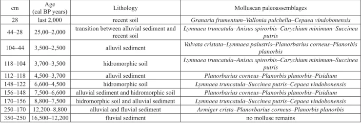
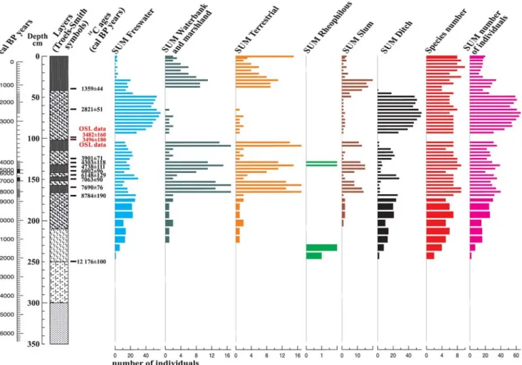
Analysis of mollusk remains
The upper 2.5 m of our studied profile yielded 1577 specimens of 18 mollusk taxa: 8 freshwater, 8 terrestrial gastropods and 2 bivalves (Figs. 8, 9). The lowermost part of the profile was non-fossiliferous. Despite the relatively large sample volume the number of identified specimens (NISP) was low. Out of the 62 samples studied only 51 had remains suitable for identification. Signs of partial dis- solution was noticeable on some shells. Furthermore, the interval between 0.96 and 1.04 m from the fossiliferous part yielded no shells at all. Most shells – over 90% – represent- ing the bivalve taxon Pisidium were highly fragmented and thus were left out of the quantification. The NISP ranged between 2 and 10 in the uppermost part, while it was be- tween 2–66 in the lower part of the profile (Figs. 8, 9).
Although NISPs are below the limits generally expected for reliable statistical evaluations (>100) (Krolopp, 1973, 1983), yet the general paleoecological picture drawn from the faunal composition seems acceptable. So, no taxa had to be merged in order to achieve the expected limit (Figs. 9, 10). All in all, 9 malacological zones were identified and seem to have a close relationship with the lithology of the embedding sediment (Table 5).
Zone 1, representing an Armiger crista–Planorbarius cor neus–Planorbis planorbis paleo assemblage, is found between the depths of 2.5 and 1.7 m (12,200–8,900 cal years BP).
The entire zone is generally prevailed by still water elements (Planorbarius corneus, Planorbis planorbis, Armiger crista) with rheophylous (moving-water loving) taxa present only during the first part (Figs. 8, 9). There is a single terrestrial taxon present highly subordinately in the samples Succinea putris. This taxon is present in water bank as well as back swamp areas.
Zone 2 (1.70 and 1.56 m, 8,800–7,500 cal years BP) is prevailed by the taxa freshwater gastropod taxon Lymnaea truncatula in addition to such terrestrial taxa as Succinea putris–Cepaea vindobonensis. This paleo assemblage is characterized by a clear prevalence of terrestrial taxa.
Among the freshwater taxa species tolerating temporary desiccation also turn up (Lymnaea truncatula, Pisidium).
This assemblage was recorded in a hydromorphic paleosol complex, which must have developed as a result of flooding (Figs. 8, 9).
There is a marked increase in the number of freshwater taxa in Zone 3 (1.56 and 1.48 m, 7,500–6,600 cal years BP). This is mainly seen on taxa preferring permanent inundation and vegetation cover. Conversely, the ratio of the representatives of the taxon Pisidium with a prefer- ence for temporal inundation was similarly high marking
the emergence of a Planorbarius corneus–Planorbis pla- norbis–Pisidium paleo-assemblage. Although the mollusk fauna clearly indicates the permanent inundation of the back swamp, this is not seen in the pollen record yielding merely such taxa as Ranunculus, Cpyperaceae as a result of highly selective preservation mentioned earlier.
Table 5. Distribution of identified malacological paleo–assemblages in the studied profile by age, depth and embedding sediment.
cm Age
(cal BP years) Lithology Molluscan paleoassemblages
28 last 2,000 recent soil Granaria frumentum–Vallonia pulchella–Cepaea vindobonensis
44–28 25,00–2,000 transition between alluvial sediment and recent soil
Lymnaea truncatula–Anisus spirorbis–Carychium minimum–Succinea putris
104–44 3,500–2,500 alluvil sediment Valvata cristata–Lymnaea palustris–Planorbarius corneus–Planorbis planorbis
118–104 3,700–3,500 hidromorphic soil Lymnaea truncatula–Anisus spirorbis–Carychium minimum–Succinea putris
112–118 4,500–3,700 alluvil sediment Planorbarius corneus–Planorbis planorbis–Pisidium 148–122 6,600–4,500 hidromorphic soil Lymnaea truncatula–Succinea putris–Cepaea vindobonensis 156–148 7,500–6,600 alluvial sediment and hidromorphic soil Planorbarius corneus–Planorbis planorbis–Pisidium 170–156 8,800–7,500 hidromorphic soil and alluvial sediment Lymnaea truncatula–Succinea putris–Cepaea vindobonensis 250–170 12,200–8,800 alluvial and fluvial sediment Armiger crista–Planorbarius corneus–Planorbis planorbis
350–250 16,500–12,200 fluvial sediment no mollusc remains
Fig. 8. Abundances of identified mollusk taxa based on number of individuals (NISP) counts.
There is a significant change in Zone 4 (1.48 and 1.22 m, 6,600–4,500 cal years BP) with a major increase in the ratio of terrestrial gastropods accompanied by a drop in freshwater taxa apart from the mussel taxon Pisidium.
This zone is characterized by the recurrence of a Lymnaea truncatula–Succinea putris–Cepaea vindobonensis paleo assemblage and the development of a hydromorphic pedo- complex (Figs. 8, 9).
In Zone 5 (1.22–1.18 m and 4,500–3,700 cal years BP) there is another sudden increase in freshwater taxa mainly those preferring permanent inundation and the presence of lush aquatic vegetation. There is a recurrence of the so-called Planorbarius corneus–Planorbis planorbis–Pisi- dium paleo-assemblage with conditions like Zone 3.
There is a decrease in the numbers of freshwater taxa in the next mollusk zone (1.18–1.04 cm and 3,700–3,500 cal years BP) except for taxa tolerating temporary water cover- age like Lymnaea truncatula, Anisus spirorbis. Conversely, the number of terrestrial taxa increased. This increase is especially notable among water bank and marshland taxa like Carychium minimum, Succinea putris hallmarking the development of a new Lymnaea truncatula–Anisus spiror- bis–Carychium minimum, Succinea putris paleo-assem-
blage. The presence of numerous molds and the relatively high numbers of the gastropod taxa Anisus spirorbis hint to the emergence of alkaline conditions within the marshland, which might have triggered the partial dissolution of the shells. This horizon is also characterized by the development of a hydromorphic soil with features indicating periodic in- undation. The layers overlying the paleosol yielded no shells at all between the depths of 0.96 and 1.04 m. It was this hori- zon where most of the disintegrated molds were concentrated clearly indicating a secondary dissolution of the shells.
In Zone 7 (1.04–0.44 cm and 3,500–2,500 cal years BP), terrestrial taxa completely disappear giving way to a new paleo assemblage composed of ditch species (Valvata cri- stata, Lymnaea palustris, Planorbarius corneus, Planorbis planorbis). These again are characterized by a preference for permanent inundation and lush aquatic vegetation in their habitat. This zone also yielded the highest specimen numbers in the entire profile.
Zone 8 (0.44–0.28 m and 2,500–2,000 cal years BP) marks the complete disappearance of taxa preferring con- stant inundation and the occurrence of the so-called slum taxa like Lymnaea truncatula and Anisus spirorbis. This is accompanied by an increase in water bank and marshland
Fig. 9. Abundances of identified mollusk taxa by paleoecological groups.
terrestrial taxa like Carychium minimum and Succinea pu- tris. All this hallmark the expansion of the back swamp during the Late Iron Age and the development of hydro- morphic soils connected to partial desiccation.
The uppermost 0.28 m representing the period of the last 2000 years corresponds to Zone 9. Here a marked dominance of terrestrial fauna was observed with a preva- lence of drought-tolerant xerophilic taxa e.g. Granaria fru- mentum, Pupilla muscorum, Chondrula tridens, Vallonia costata, Cepaea vindobonensis. In addition, proportions of the strongly hygrophillic Succinea putris and Vallonia pulchella populating nearbank areas and wet meadows was likewise high (Figs. 8, 9). Slum and ditch species like Lymnaea truncatula, Anisus spirorbis harboring ponds and temporary mud pools also turn up in this zone. The accurate evaluation of this horizon was not without hardships due to the plow-induced disturbance and mixing of the soil. A marked slide was recorded between the depths of 0.38 and 0.42 m. The topsoil yielded some poorly preserved speci- mens of the terrestrial gastropod taxa Chondrula tridens and Vallonia pulchella. All in all, the recurring nature of mollusk paleo assemblages throughout the profile is in line with the observed cyclicity of the sediment indicating re- curring flood cycles on the floodplain. The height, length, strength of these floods, the degree of succeeding desicca- tion, the composition of the transported sediment has all had an impact in shaping the faunal composition.
RECONSTRUCTED ENVIRONMENTAL HISTORY OF THE AREA
According to the literature, the geological evolution of the Csorna Plain was controlled by one of the largest trib- utaries of the Danube, the Raab or Rába River forming an alluvial fan, which was actively developing until the Late Glacial (Pécsi, 1959, 1962; Somogyi, 1961; Gábris, 1985, 1995, 1998, 2002; Gábris and Nádor, 2007; Lovász, 2007).
What’s more a recent archeological paper went as far as to consider the entire plain an integral part of this alluvial fan system (Mester et al., 2014, 2015).
Our findings are at total odds with these theoretical assumptions. Based on our results, the Csorna Plain hosted a system of Late Glacial small fluvial channels running parallelly with a SE-NW trend (Figs. 1, 10). Conversely, the channel of the larger Rába River has utterly differing orien- tation and size, which cannot explain the mentioned geolog- ical and geomorphological structure of the fluvial network of the Csorna Plain (Sümegi et al., 2012). The geological features identified at the excavation site of Csorna–Lórét revealed a complex fluvial system of a Late Glacial creek with its complete sub facies ranging from channel deposits, a clay plug, a point bar, levee series with an alternation of slack water fines and floodwater sands (Fig. 2) (Ghinassi et al., 2016). According to 14C dates, the channel deposits accumulated during the Late Glacial preceding 12,200 cal years BP. The trajectory of the creek is perpendicular to the Rába riverbed. Detailed analysis of historical maps and
digital elevation models created using aerial photographs and cartographic data revealed the presence of parallel creek beds starting out from the area of the Transdanubian Hills found to the SE (Fig. 10) forming an alluvial fan inde- pendently from that of the Holocene Rába River during the Late Glacial (18–22 kyrs).
The development of this independent alluvial fan com- plex is attributable to the different position and subsid- ence rates of neotectonic basins during this time from their modern counterparts as seen on maps recording the thick- ness of Quaternary fluvial deposits (Sümeghy, 1944; Jaskó, 1935). During this time, the fluvial network was made up of parallelly running creeks with a NW-SE trend including the creek observed at our site and the Rába River itself too. Neotectonic activities were displaced following the LGM leading to the emergence of new sub basins pro- viding new accommodation areas for fluvial deposits. As a result, the course of the Rába River was also displaced into its modern position running into the NE (Fig. 10). This major shift beheaded the former parallelly running system of creeks turning them into inactive drainage channels un-
Fig. 10. The system of parallel-running creeks with a NW-SE trend observed on the digital elevation model of the wider surroundings of the Csorna Plain. Note the perpendicular trajectory of the modern Rába River to the section A-B-C.
dergoing gradual infilling during the past 14,000–12,000 years. Conversely, the righthand tributaries of the Rába River found closer to the Transdanubian Hills remained actively developing. The natural endowments of our study site and their short as well as long-term changes must have had fundamental impact on the settlement and subsistence strategies of human cultures settling in the area. In the next part, a review of these is given regarding the individual archeological periods (Fig. 11).
Upper Paleolithic–Late Paleolithic (>16 kyrs)
During this time, the study area was characterized by fluvial activity leading to the development of a complex creek bed and floodplain system. The emerging geomor- phological units found at differing heights and later covered by Late Glacial and Holocene deposits had profound effects on the future development of soils and vegetation offering different possibilities for human settlement and landscape exploitation.
Epipaleolithic (12–16 kyrs)
As a result of the displacement of neotectonic activity in the area of the Little Hungarian Basin, fluvial sedimen- tation ceased in our study area due to a beheading of the creek beds by the Rába River. The former channels became inactive drainage channels of the new floodplain, which were characterized by moving water conditions during the flooding of the Rába River only. Recurrent sediment ac- cumulation during floods lead to the gradual infilling of the former Ice Age fluvial system and subsystems. This period was mainly characterized by the accumulation of coarse silts and sands in the deeper parts of the concave floodplain.
Early Mesolithic (12–9.5 kyrs)
The low-lying areas of the floodplain experienced a significant accumulation of coarse silts and very fine, fine sands. Due to the extensive recurring inundation of the
Fig. 11. Graphs displaying the identified local pollen and malacological zones and corresponding archeological periods in the studied profile.
floodplain freshwater mollusks inhabiting moving wa- ter habitats also turned up. The adjacent terrestrial areas hosted a mixed taiga woodland having a vegetation similar to the Pre-Alpine and Sub-Carpathian regions (Willis et al., 1997, 1998; Sümegi, 1999; Juhász, 2007a–c; Magyari et al., 2009; Sümegi and Törőcsik, 2007; Törőcsik et al., 2014, 2015; Sümegi and Náfrádi, 2015; Sümegi et al., 2012). The composition of the vegetation was in line with the one pre- sumed for the so-called Birch-Pine phase of the Holocene (Zólyomi, 1952).
Late Mesolithic (9.5–7.6 kyrs)
This period hallmarks the initiation of cyclical sediment accumulation of carbonate rich silts and organic rich clays on the floodplain and the development of hydromorphic soils. During the Late Mesolithic mixed taiga woodlands were exchanged for hardwood and softwood deciduous woodlands. The former was clearly prevailed by oak com- plemented by other hardwood elements of ash and elm in addition to scattered stands of hazelnut. Softwood gallery forests were made up of stands of willow and alder. The first appearance and general homogenization of deciduous woodlands and the expansion of oak happened during this period in other parts of the Carpathian Basin too (Willis et al., 1997, 1998; Sümegi, 1999; Juhász, 2007a–c; Magyari et al., 2009; Sümegi and Törőcsik, 2007; Törőcsik et al., 2014, 2015; Sümegi and Náfrádi, 2015; Sümegi et al., 2012).
Neolithic (7.6/7.5–6.5 kyrs)
This period is characterized by the development of two silt-rich horizons connected to flooding during times of higher rainfall with two intercalating clayey marshland de- posits and hydromorphic soils marking drier climatic condi- tions. Hydromorphic soils yielded hygrophilous water bank and marshland terrestrial gastropods. On the other hand, floodplain deposits are characterized by clear dominance freshwater taxa with a preference for constant water cov- erage. The opening of the Neolithic also hallmarked the appearance of beech and alder as well as cereals and weeds.
Their increasing ratio clearly indicate rising human pressure on the environment connected to agricultural activities. The records of Middle Neolithic architecture clearly refer to the development of a local settlement in our study area.
Copper Age (6.5–2.5 kyrs)
Influences of human activities on the landscape re- mained significant. This period is characterized by the development of horizon containing slash water fines and hallmarking a climate with higher rainfall. A horizon of hydromorphic soils however indicates the presence of an- other drier climatic phase during the Copper Age in addi- tion to the former wet phase. These are clearly reflected in
the composition of the mollusk fauna as well. The pollen composition of the Copper Age remained the same as the Late Neolithic.
Bronze Age (2.5–0.9 kyrs)
Numerous alternating floodplain and hydromorphic soil horizons record the cyclical succession of wet and dry climatic periods during the Bronze Age. The Early Bronze Age must have had a wetter climate as seen from our sedi- ment and malacological records. Drier conditions emerged during the terminal part of the Bronze Age and were sus- tained during the Middle Bronze Age. The terminal part of the Middle Bronze Age records the climate with the highest rainfall. This continued onto the Early Iron Age as well.
Based on the observed pollen composition and the found Early Bronze Age archeology indicating the development of another settlement in our study are marks major changes in the vegetation. There is a major decline in the ratio of arboreal elements with the reappearance of cereals and new type of weeds. In addition, the first records of walnut pollen grains are also connected to this period.
Early Iron Age (0.9 and 0.6 kyrs)
The former wet climatic phase persisted during the en- tire Iron Age as seen in the prevalence of a mollusk fauna with a preference for constant water cover in addition to the clayey silts of floodplain deposits. There is no major change in the pollen composition compared to the Bronze Age indicating the continuation of similar human activities in the area. The appearance of the archeology of the Hallstatt Culture marking another settlement in the area is in line with the inferred vegetation composition and landscape reconstruction.
Late Iron Age (0.6 kyrs–0 AD)
This period marks the initiation of pedogenesis on floodplain deposits of the Bronze Age and Early Iron Age leading to the development of the modern topsoil. The com- position of the mollusk fauna indicates a gradual desicca- tion. The pollen composition was not suitable for evaluation due to mixing and erosion connected to drainage activities and plowing.
Last 2000 years
The last 2000 years represent the development of the modern soil. The presence of water bank and marshland mollusk taxa in addition to drought tolerating elements in- dicate the presence of a highly complex environment com- posed of mosaics. The original soil must have been a hy- dromorphic luvisol which was turned into a hydromorphic