V: Sapientia Hungarian University of Transylvania, Environmental Science Department, 4 Calea Turzii, 400112 Cluj-Napoca, Romania
totha@sapientia.ro
VI: Laboratory of Environmental Studies, Institute of Nuclear Research of the Hungarian Academy of Sciences, 18/C Bem tér, H-4025 Debrecen, Hungary
sumegi.balazs.pal@gmail.com
Abstract: The medieval market-town of Sic (Szék in Hungarian) was an important Transylvanian settlement due to its remarkable salt mining. The impact of the mining activities on the environment and the history of water management were investi- gated based on a palaeoecological study, performed on the large Reedbed of Sic (Stufărişurile/Nádas-tó). We found that in the last 3000 years the anthropogenic impact has been continuous in the territory, but the types and intensity of the disturbances changed with time. The most notable environmental transitions took place after 1000 AD, suggesting a significant intensification of salt mining.
Forest cover significantly drop, but salt concentration and the frequency of halophytic species in the investigated marshland increased during the Late Middle Ages. The dominance of halophytic marshland species reached their peak in the 17th century. This coincides with the apogee of mining activities and human lake management. The most remarkable deforestation occurred in the 18th century, when the present-day landscape with negligible forest cover was developed.
Keywords: Middle Ages, fishponds, salt mining, palynology, radiocarbon dating, geochemistry
I. INTRODUCTION
The research of the Transylvanian Sic settlement was carried out in the framework of a larger study, focus- ing on the medieval environmental history of the Carpathian Basin. Its primary purpose was to examine the human induced long process which led to the typical barren landscape of the Transylvanian Meadow-land (Câmpie/
Mezőség), with its negligible forest cover. Primarily Sic was chosen because its large, undisturbed reed lake was found to be suitable for sediment sampling. Therefore the multi-perspective analysis of the samples taken from the reed’s sediment (sedimentology, geochemistry, pollen, plant macrofossils and other remains) with the addition of radiocarbon measurements offered a large variety of data on environmental history. The selection of the site was also influenced by the fact that it was one of the important salting places in Transylvania, where salt mining was assumed to have existed in the Roman times, and it is attested by many documents from the Arpadian period (1001–1301) until to the 18th century. The importance of the studied site for the environmental reconstructions is underlined by the fact that the natural environment and built-in area of Sic has not been changed significantly since
(SIC, NORTHERN ROMANIA)
GUSZTÁV JAKABI,II – LÓRÁND SILYEIII – PÁL SÜMEGII,IV – TÜNDE TÖRŐCSIKIV – ATTILA TÓTHV – BALÁZS PÁL SÜMEGIVI – ELEK BENKŐI
I: Hungarian Academy of Sciences, Research Centre for the Humanities, Institute of Archaeology, 4 Tóth Kálmán u., H-1097 Budapest, Hungary
benko.elek@btk.mta.hu; jakab.gusztav@gk.szie.hu;
II: Szent István University, Faculty of Agricultural and Economics Studies, 1–3 Szabadság út, H-5540 Szarvas, Hungary,
III: Babeș-Bolyai University, Department of Geology, 1 Mihail Kogălniceanu, 400048 Cluj-Napoca, Romania
lorand.silye@ubbcluj.ro
IV: University of Szeged, Department of Geology and Palaeontology, 2–6 Egyetem u., H-6722 Szeged, Hungary
sumegi@geo.u-szeged.hu, sumegi.tunde@gmf.u-szeged.hu
Acta Archaeologica Academiae Scientiarum Hungaricae 69 (2018) 185–206 DOI: 10.1556/072.2018.69.1.8
the Early Modern period, and the salt mining did not completely altered the original environment. Hence the surface traces of mining can be studied as well as the remains of medieval and early modern fish ponds around the former mine. From the 15th–18th centuries an abundance of written sources refers to the former fish ponds. The present multidisciplinary study attempts to link archaeological, historical evidences and data on various environmental and ecological parameters to better a constrain the human induced environmental changes
II. STUDY SITE
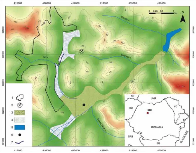
The Reedbed of Sic (Stufarisurile/Nádas-tó) is the second largest reedy habitat after the Danube Delta in Romania (Fig. 1). It is located in the NW Transylvanian Basin, at the confluence of Coastei and Sic creeks (both tributary of the Fizeş basin), close to Sic village. This region forms the contact area between the so-called Transyl- vanian Plain and the Someş Plateau, characterized by 450–550 m high hills, and large wetlands (lakes and swamps) in the valleys. Today, the climate of the region is temperate continental, being characterized by 7–9 °C annual mean temperature and 550–600 mm annual mean precipitation with the highest values in boreal spring and summer.1
1 Mac et al. 1987.
Fig. 1. Overview map of the investigated area around Sic.
1: settlement – Sic village; 2: abandoned salt mine; 3: reedbeds; 4: salty meadows; 5: lake; 6: core point;
7: ditch with a map showing the position of Sic village in Romania
The hilly surfaces around Sic comprise of middle Miocene (Badenian and Sarmatian) siliciclastics, whilst along the valleys Quaternary alluvial deposits occur. However, the geological setting is mainly controlled by the structural features of the area, because the hinge zone of a large NE–SW oriented anticline is located just east of Sic.2 As a consequence, the Badenian sedimentary record is exposed along the hinge zone of the anticline i.e. mostly the lower and middle part of the hills. It is mainly formed by dacitic volcanic tuff (Dej Tuff), covered by evaporite (salt) interbedded with thin shales (Ocna Dejului Formation), and topped by finely stratified marls with minor sandstone intercalations. The middle part of this Badenian sedimentary sequence, the salt layer, however crops out in only one place, located just NE of Sic.3 During the Quaternary, the climate changes and the high sediment supply vs. rivers high base level and decreased transport capacity filled up the valleys, generating wetlands in the floodplain (lakes and swamps).4
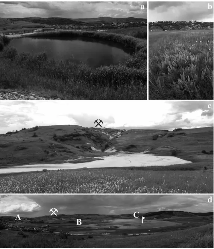
The traces of the medieval salt mining and related human activities are easily observable even today in the eastern side of Sic. For instance, an about 30 m wide shaft filled with rainwater is still open on the top of the Salt- hill (Sós-hegy, Fig. 2a). Next to the shaft a large deposit of salty clay is visible (Fig. 2c). This was most probably deposited from the mining related salty wastewaters over the centuries. The salty liquid and semi-liquid industrial waste was collected into a southwards oriented ditch, which drained the wastewater into the studied lake (see ‘B’
sign on Fig. 2d).
The surface of the Reedbed of Sic is covered by extensive saline meadows and salt marshes (Fig. 2b) with diverse and zonated halophytic vegetation.5 Depending on the salt content and water-depth different plant associa- tions follow each other.6 The Reedbed of Sic is surrounded by bare hills with dry grasslands and small spots of blackthorn/Prunus spinosa and common hawthorn/Crataegus monogyna shrub. Natural grasslands formed due to the climatic and pedological conditions, covered large proportion of the region before the landscape suffered anth- ropogenic alteration. Most often Festuca rupicola dominated dry step grasslands with Stipa pennata, Adonis ver- nalis, Carex humilis, Aster amellus, Salvia transsilvanica and Astragalus monspenssulanus covers the upper parts of the hills.7 During the last centuries the forest cover decreased remarkably in the region. After the forest clearance xeromesophilous grasslands with Brachypodium pinnatum emerged on the hills. It is very difficult to evaluate the original proportion of natural forests and grasslands, but past forest cover could have been much larger than today.
The first victim of deforestation were most probably the xerophilous oak forests with pubescent oak/Quercus pu- bescens and Tatar maple/Acer tataricum, which are extremely rare in the region nowadays. The most common forest type is the wood with sessile oak/Quercus petraea and common hornbeam/Carpinus betulus. Anthropogenic disturbances evolved monodominant Carpinus betulus stands. In these forests pedunculate oak/Quercus robur, European beech/Fagus sylvatica, European ash/Fraxinus excelsior, field maple/Acer campestre, small-leaved lime/
Tilia cordata, field elm/Ulmus minor and wild cherry/Prunus avium are the secondary trees. In small patches Fagus sylvatica dominated forests present in the region as well. In the 20th century plantations of exotic trees (eg. black pine/Pinus nigra, black locust/Robinia pseudoacacia) spread in the region.8 Nevertheless, forest cover is very low around the investigated area, and only a small patch of oak forest exists in the vicinity of the studied site.
Cultivated fields, like gardens and ploughlands cover less than 10% of the administrative area of Sic, and are situated either in the inner, settled zone of the village or in some of the valleys not covered with settlements. The areal pattern of cultivated fields is determined fundamentally by the distribution of soil types. As the top parts of the hills are too dry and the low-lying parts of valleys are regularly covered with water and polluted with salt, crop production is restricted in these areas.
III. HISTORICAL BACKGROUND
Sic (in the Middle Ages: Székakna, ‘Mine Szék’) was a market-town of the medieval county Doboka in Transylvania. Here a salt-mine was operated under the authority of the Hungarian king, and was one of Transylva-
2 Răileanu–Saulea 1968.
3 KRézSeK–FilipeScu 2005; KRézSeK–Bally 2006.
4 Mac et al. 1987; Budui–peRşoiu 2014; VeReSS et al. 2014.
5 pop et al. 1983; pop–cRiStea–Hodişan 2002.
6 coldea et al. 1997; doniţă et al. 2005; Sanda– ÖlleReR–BuReScu 2008.
7 cRiStea–Başnou–puşcaş 2008; cSűRÖS 1973.
8 cRiStea–Başnou–puşcaş 2008; cSűRÖS 1973.
Fig. 2. Landscape features and remains of anthropogenic impacts around Sic. a: waterfilled medieval salt mine;
b: halophytic vegetation near the village with Triglochin palustre and Plantago cornuti; c: saline mud accumulation near the mine;
d: panoramic view from the former sentinel house of the investigated area (A: settlement; B: the end point of the salt mines the draining ditch;
C: the former position of a medieval watermill and the coring point mark a flag)
nia’s most important five salt-works (Turda/Torda, Dej/Dés, Cojocna/Kolozs, Sic/Szék, Ocna Sibiului/Vízakna).9 Archaeologists suppose that the salt deposit of Szék was worked even in the Roman period, but this assumption is supported only by sporadic Roman settlement remains.10 There are no archaeological evidences for re-use of the salt-mine in the decades following the Hungarian conquest (895), nevertheless a document dated from 1326 states that the mining from Sic went back to the time of the ‘holy kings’,11 i.e. the age of Saint (I.) Stephen (1001–1038) or Saint (I.) Ladislas (1077–1095), at any rate in the the first half of the Arpadian period (1001–1301). The signifi- cance of the settlement can be underlined by the assumption, that the medieval church of Szék (currently in the use of the Reformed/Calvinist Church)12 can be identified with the Premonstratensian provostry Zich, enumerated in the Catalogus Ninivensis (1234).13 The chamber of salt at Sic was first mentioned in 1310,14 and since then the chamber and its board appeared regularly in the documents issued in the 14th–15th centuries.15 Nevertheless, we don’t dispose of any details concerning the volume or the temporary breaks of salt mining in Szék. In 1523 the chamber was still under the control of the king,16 but from 1534 onwards it appears in pawn of private entrepreneurs until the beginning of the 17th century. Henceforth the salt production seems to be on rised continuously, under the authority of the Prince of Transylvania. In 1638 20 000 salt blocks were exploited and carried to the Mureş/Maros river in order to be transported towards the central parts of Hungary. According to an inventory from 1660, there were two exploited salt mines in Sic, a smaller and a larger one, both worked by help of animal power. Underneath there was a fishpond belonging to the finances of the Prince of Transylvania.17 This was probably the golden age of salt min- ing in Szék. At the beginning of the 18th century, the salt production had declined significantly. According to an inventory from 1732, the mining site was ruined. Although the building had been repaired at this time, in 1822 the mining had been ceased definitively and the shaft was filled up with earth. There are two stone columns above the remains of the mine, surviving till our days, with a longer inscription, which states that the mine had two mouths, each of them 7 fathoms (13.3 m). The cavity itself was 48 fathoms (91.2 m) deep and 39 fathoms (74.1 m) wide.18
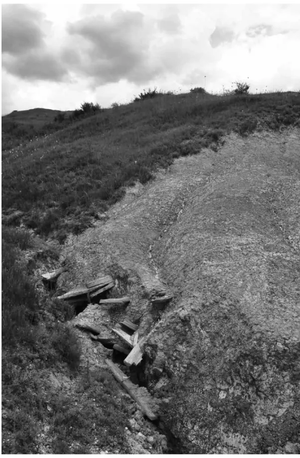
Apart from the above-mentioned data we do not know anything about the medieval and early modern his- tory of the salt-works in Sic and do not dispose of any data concerning the production methods used. Therefore we can only rely on sparse data and assumptions, which presume the open-pit salt mining for the Roman period, while for the Arpadian period Transylvania (especially in the Szeklerland) open casting than deep cultivation is sup- posed.19 However, others believe that salt mining with deep cultivation has been in practice since the 12th–13th centuries.20 In order to clarify this issue, an important new archaeological data should be considered. The data is based on the wood remains collected during our field research in Sic. When a surface survey of the former salt mine was performed, on the western side of the hill we observed the remains of a collapsed woodwork, washed out from the ground at the bottom of a deep waterfall. (Fig. 3)
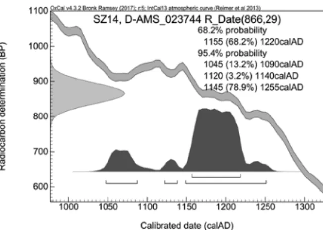
The calibrated radiocarbon age of a wood sample found there resulted 1155–1220 cal AD with 68.2%
probability (one sigma), while with a probability of 95.4% (two sigma) it was calibrated to 1045–1255 cal AD. (Fig.
4) This confirms the practice of underground salt mining at Sic in the middle of the Arpadian period (12th century), proven by the existence of contemporary woodworks. Although this is an important result, we admit, that this ques- tion could be fully solved by archaeological exploration of the underground wood constructions and further den- drochronological and radiocarbon tests of several samples, only. Until then our new data supports the assumption that the salt mines mentioned in the documents of the Arpadian period (1177: akna, 1222: akana)21 were not simple open-pit mining pots, but deeper shafts, lined with wood.
Besides the traces of salt mining, in the investigated area the remains of old fish ponds, known from and early modern written sources, are still observable. The fishponds around Sic were the western representatives of the so-called ‘Transylvanian Lake District’, which consisted of at least 60 artificial lakes in the Middle Ages.22 The main medieval landowners in Sic (the officers of the royal salt chamber, the priests of the Roman Catholic Church, and secular noblemen who owned land properties in Sic as royal donations) constructed several fishponds and mills over
9 GyÖRFFy 1987, 87–88.
10 RepeRtoRiu 1992, 342–353; FaRKaS 2007; FaRKaS– KiSS 2008.
11 JaKó 2004, 210. (nr. 564.)
12 entz–K. SeBeStyén 1947.
13 HoRVátH 2002, 5–21.
14 JaKó 2004, 87. (nr. 162.)
15 JaKó 2004, passim.
16 JaKó 1990, II. 404. (nr. 3897.)
17 For the above data, see: KádáR 1903, 380.
18 KádáR 1903, 380.
19 dRaSKóczy 2014, 829.
20 WollMann 1996, 417; dRaSKóczy 2014, 829.
21 JaKó 1997, 126 (nr. 13), 155 (nr. 119).
22 SztRipSzKy 1903.
Fig. 3. Sic-Bányahegy, remnants of woodwork near the former salt mine
them.23 Our earliest data in this matter comes from 1454. In that year there were two fishponds, one of them in the property of Nicolaus de Vizakna, vice voivode of Transylvania, whilst the other one belonged to Odwardus Italicus, first officer of the salt-chamber at Dés; this latter was damaged by floods (propter nimiam tumositatem aque esset in ruina). The two fishponds lay along the same stream (in uno alveo existeret), causing mutual damages, which led to several legal proceedings.24 These documents prove that the main cause of the litigations was the lowering of water-level before fishing the ponds, without the agreement of other owners, as this could provoke serious damages in fishponds, which lay deeper. Such legal actions connected to fishponds at Sic were frequent in the 15th–16th cen- turies (e.g. 1465, 1479, 1489, 1491, 1498, 1504, 1525).25 One of the fishponds of medieval origin, the Kodori-tó (‘Lake of Kodori’) reminds of the medieval Kodori family, descendant of the Italian salt-chamber officers at Dés.26 In 1616, existed a “Kalandas tó” in Szék; its name refers to a medieval religious found which held its meetings around the first day of the month (Kalendae in the Roman calendar). This was probably the fishpond of the parish church in Szék. Two other ponds appeared in 1643: the Pásztoráj and the Új-tó (‘New pond’). This latter may be located by means of cartographical sources eastwards from Nádas Lake.27
In 1727, the fishponds of Szék, all in the property of the finances, were enumerated: 1) Csukás-tó (‘Pike Lake’), completely filled with water, having different sorts of fishes (plenus aqua ex variis piscibus habet abundan- tiam), 2) Pásztoráj, not too deep, with many smaller fishes (parvulis piscibus abundans non adeo profunda aqua gaudet), 3) Kodori-tó (‘Lake of family Kodori’), with less water and small fishes (aqua exigua impletus parvulis piscibus existens lacus), and 4) Széles-tó (‘Large Lake’), without any data. A document from 1754 informs us that the lake named Pásztoráj lay in the Beszterce valley, east of the village.28
It is instructive that in the documents of the 18th–19th centuries the former mills built to the ponds appear scarcely, albeit their places are still identifiable on the maps of this period. At the beginning of the 19th century the Nádas Lake was abandoned and a new lake was established eastwards (Új-tó, ‘New Lake’).
IV. ENVIRONMENTAL ARCHAEOLOGICAL METHODS
The studied 1.6 m long sediment core was recovered from the central part of the lakebed (Fig. 1) using a modified 1 m long ‘Russian corer’ with steel bars.29 The lithostratigraphical description of the profiles followed the system of Troels-Smith (1955). The grain size analysis of the samples (42 grains-size intervals between 0.0001 and 0.5 mm) was performed using the laser-sedigraph method.30 For LOI examination sub-samples were taken at every 2 cm intervals and the commonly used loss on ignition method was applied.31 The element composition of the water
23 entz 1996, 463; JaKó 1990, passim.
24 JaKó 1990, 487 (nr. 1151).
25 JaKó 1990, passim.
26 JaKó 1990, I. 784–785 (nr. 2284); II. 68 (nr. 2706), 73 (nr. 2725), 166 (nr. 3060), 462 (4111).
27 SzaBó 2007, 566.
28 SzaBó 2007, 567–568.
29 SüMeGi 2001.
30 SüMeGi et al. 2015.
31 dean 1974.
Fig. 4. Sic-Bányahegy, medieval woodwork, radiocarbon measurement results of a studied sample (DirectAMS, Seattle, USA)
solutions was examined with a PerkinElmer AAnalyst 100 atomic absorption spectrophotometer. The pH values were measured with glass microelectrodes.32
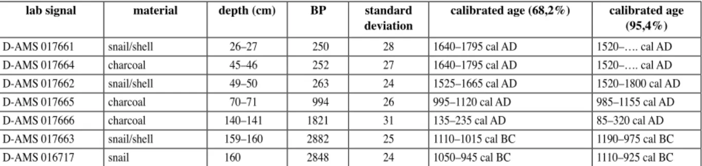
The radiocarbon dating (DirectAMS, Seattle, USA) was performed on the wood and mollusca fragments recovered from different sediment layers of the undisturbed core sequences. 6 out of the 13 organic samples from the pond sedimentwere defective for unknown reasons (D-AMS 015580-015582, 016718-016720), so we did not use them in the analysis.
Table 1. Results of AMS dating of the studied core (DirectAMS, Seattle, USA)
lab signal material depth (cm) BP standard
deviation calibrated age (68,2%) calibrated age (95,4%)
D-AMS 017661 snail/shell 26–27 250 28 1640–1795 cal AD 1520–…. cal AD
D-AMS 017664 charcoal 45–46 252 27 1640–1795 cal AD 1520–…. cal AD
D-AMS 017662 snail/shell 49–50 263 24 1525–1665 cal AD 1520–1800 cal AD
D-AMS 017665 charcoal 70–71 994 26 995–1120 cal AD 985–1155 cal AD
D-AMS 017666 charcoal 140–141 1821 31 135–235 cal AD 85–320 cal AD
D-AMS 017663 snail/shell 159–160 2882 25 1110–1015 cal BC 1190–975 cal BC
D-AMS 016717 snail 160 2848 24 1050–945 cal BC 1110–925 cal BC
The core was analysed at 4 cm intervals for macrofossils. Samples were disaggregated if necessary and wet-sieved with a 250 µm mesh.33 The sequence was sampled for pollen at 1–2-cm intervals. Samples of 4 cm3 wet sediment were prepared for pollen analysis at the pollen laboratory of the Department of Geology and Palaeonto- logy, Szeged University using standard methods and micro-sieving by a 10 µm mesh sieve.34 Lycopodium spore tablets of known volume were added to each sample to work out pollen concentrations.35
V. RESULTS AND DISCUSSION
1. Core description and radiocarbon dating
The studied core could be divided into 11 sediment layers (Table 2) based on the sediment colour and structure. The quality of the accumulated sediment shows some variability along the core, but the frequently ob- served fine lamination of the recovered sediments suggests that the studied area was almost entirely water-covered during the accumulation of the sediments. However, the polyhedral structure of the sediment at 22 cm and between 112 and 134 cm suggest only periodic water cover.
The accumulation of the sediments started approx. 3000 years ago (see the radiocarbon data in Table 1), and had a mean accumulation rate of 0.52 mm/yr. In the lake system, formed at the confluence of streams, naturally low accumulation rates (0.15 mm/yr) occurred from the Early Iron Age to the Roman period (2nd–3rd centuries AD).
After this period the accumulation rate increased dramatically and was ~6 times higher than in the previous time- interval. This rapid sediment accumulation (0.81 mm/yr) can be attributed to the anthropogenic influences.36 The erosion was probably much more intensive during the Roman period, because the accumulated sediment was de- posited as massive sediment flows into the valley, and resulted in rapid silting of the accumulation area. The rate of accumulation slowed down in the Migration period, and only quickened again in the 8th–9th centuries and in the Arpadian period. In the interval between the 13th and 16th centuries the sedimentation had an accumulation-rate of only 0.36 mm/yr. An exceptionally high, over 3 mm/yr accumulation-rate was reconstructed for the 17th–19th cen- turies, as a result of intensive human impact on the area, and owing to this, the lake system became mire. The transition from lake to mire is a typical phenomenon caused mostly by the increased soil erosion around a lake- system.37 The accumulation rate decreased to ca. 0.97 mm/yr between the 19th and 21st centuries, which is in accord-
32 ReVSBecH–JoRGenSen–BlacKBuRn 1983.
33 JaKaB–SüMeGi–MaGyaRi 2004.
34 Bennett–WilliS 2001.
35 StocKMaRR 1971.
36 zolitScHKa–BeHRe–ScHneideR 2003; deScRoix– GautieR 2002.
37 BRaun et al. 1990; WilliS et al. 1995; WilliS et al.
1998.
Fig. 5. Calibrated AMS measurements used to date the core
ance with the historical data regarding the ceasing of the mining activity. The fluctuation of the sediment accumulation rate mirrors the intensity of the human activities i.e. the increase (2nd–3rd, 8th–12th, 17th–19th centuries AD) and decreased (19th–21st centuries AD) of the human impacts in the studied area. The periods characterized with intensified human impact yielded sediments with increased clay and salt content, and increased pH values.
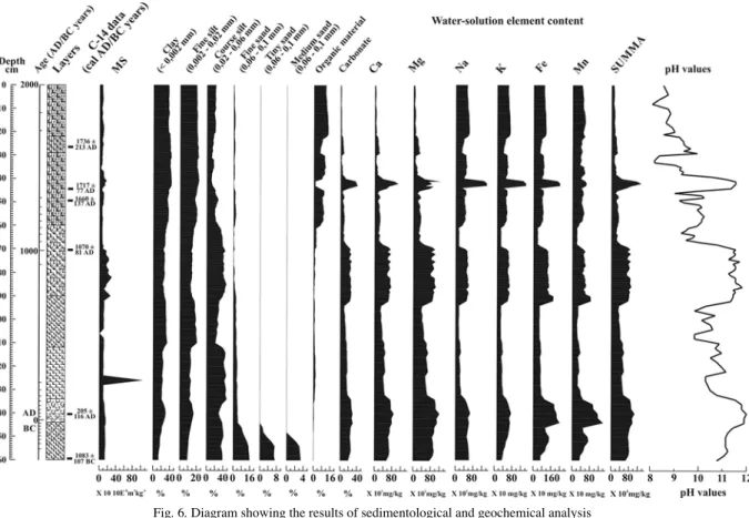
2. Geochemical and other sediment properties
The magnetic susceptibility (MS) values are quite uniform along the core with the exception of only one prominent peak between 120 and 130 cm (Fig. 6), which might indicate a desiccation period. However, the higher MS values could also refer to burning deforestation, because the burnt soil or plant-remains usually increase the MS values. The organic matter content increased in the uppermost part of the core, indicating the eutrophication of the lake system. The fluctuation of the carbonate content could be associated with the salt content and the pH value.
This might indicate that the salt lake/marsh system became sometimes supersaturated.
The fine silt and clay content increased in horizons impacted by human activity in relation to the increased soil erosion and in-wash. The coarse silt content is associated to the increased salt content and pH values. We assume that this is due to the human impact, which resulted in significant soil erosion, thus coarse silt and fine sand rich sediment could be deposited in the accumulation area.
The changes observable in the water-soluble element content (Fig. 6) might be the best indicator of human impact. Four peaks were noticed in element content, between 130 cm and 140 cm, 70 cm and 90 cm, 40 cm and 50 cm, and in the uppermost part of the profile. These horizons contained the highest salt (among them Na) content, thus the most significant salt input in the system happened probably during the deposition of the water-soluble elements.
The changes in grain-size distribution, the low organic matter and the increase of water-soluble (Na) ele- ment content in some horizons are regarded as anthropogenic saline horizons. These horizons might have been generated when the salt mining increased; hence the deposited sediments had an increased salt content. Therefore, they mark the main stages of the salt mining activities during the studied time interval, when human activity ex- ceeded the natural salt accumulation. The presence of the anthropogenic saline horizons could be dated to the Roman period (2nd–3rd centuries AD), the early Middle Age (8th–12th centuries AD) and the Early Modern period (17th–19th centuries AD). The fourth saline horizon at the uppermost part (30 cm to the top) of the core refers to the adsorption of water-soluble elements on the surface of the organic matter.
Table 2. The identified layers of the undisturbed core sequence from Sic
depth (cm) Colour Munsell colour-
scale Troels-Smith cate-
gory structure
0–22 blackish brown 10 YR 3/2 Th1Sh2As1 polyhedric
22–29 greyish black 10 YR 3/1 Th1Sh1As2 fine laminated
30–40 blackish brown 10 YR 3/2 Th1Sh2As1 fine laminated
40–43 reddish brown 10 YR 3/6 Th1Sh2As1 laminated sediment
within limonite spots
43–60 blackish brown 10 YR 3/2 Th1Sh2As1 fine laminated
60–69 greenish yellow 10 YR 5/3 Sh1Lc1As2 fine laminated
70–90 reddish yellow 10 YR 4/3 Sh1Lc1As2 laminated sediment
within limonite spots
90–112 brownish yellow 10 YR 4/4 Lc1As3 fine laminated
112–134 greyish brown 10 YR 4/4 Sh1As3 polyhedric
134–144 reddish yellow 10 YR 4/3 Sh1Lc1As2 laminated sediment
within limonite spots
144–160 ochre yellow 10 YR 5/8 Lc1As3 laminated sediment
3. Plant macrofossils and foraminifera remains
The studied core can be divided into two remarkably different parts based on the distribution of the plant macrofossils (Fig. 7). Between 160 and 70 cm the macrofossil concentrations is quite low, and the plant remains are only sporadic. Beside sedimentological results, macro remains also suggest the emergence of an astatic salt lake in the area, with sporadic vegetation cover (Fig. 8). The plant remains corresponding to the In the Roman period suggest temporary stabilization of water levels.
From the 70 cm upwards, the organic content of the sediment gradually increases indicating the stabiliza- tion of water level. According to the radiocarbon data these changes occurred during the beginning of the Arpadian period. Reed/Phragmites and rush/Juncus remains become dominant component of the sediment, together with common bulrush/Typha latifolia seeds. The developing reedbed zone filtered the leaking mine waters which allowed the fish production in the inner and less salty part of the lake.
Between 25–35 cm the amount of Phragmites remains are low and seeds of some terrestrial plants are preserved in the sediment. These clearly indicate drying mud surfaces. Above 25 cm the core reflects the previous salt marsh conditions with stabilized water level. The observed changes suggest that the lake temporary dried out in the 18th century.
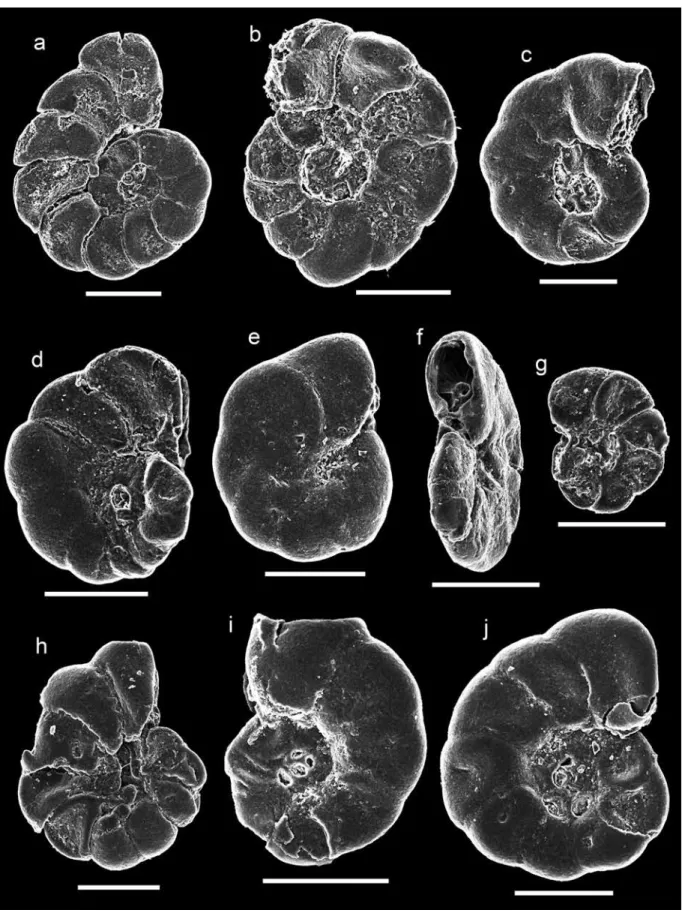
The agglutinated foraminiferal specimens belonging to the Entzia macrescens found in the core can be clearly related to the salty marshes with stable water level (Fig. 9). This species invaded the studied area in about 1000 AD, and the E. macrescens specimens had their maximum abundance around the 17th century. Entzia macres- cens is a widespread taxa of seashore salt marshes. The Entzia macrescens assemblage is restricted to a 0.06 m vertical range near the highest astronomical tidemark in saltmarsh cores.38
38 GeHRelS–Vande plaSScHe 1999; Scott–Medioli 1978.
Fig. 6. Diagram showing the results of sedimentological and geochemical analysis
Fig. 7. Macrofossil and foraminifera diagram from Sic (seeds and foraminifera tests: specimen*10cm-3 ; other macrofossils: specimen*cm-3).
R: rhizomes; E: ephippia; S: seed; o: ogonia; a: gemmule; L: leaf
Fig. 8. Plant macrofossils from Sic.
a: Najas minor leaf; b: Triglochin palustre seeds; c: Phragmites australis seed; d: Schoenoplectus tabernaemontani seed
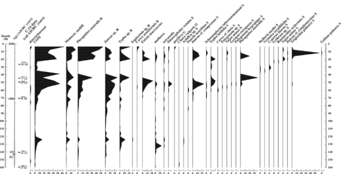
4. Pollen remains
10 local pollen zones can be separated based on the statistical analysis of the pollen remains. The first local pollen zone corresponds to 160 and 148 cm (cal BC 1190–400). Its pollen spectra have only moderate proportions (72–60%) of pollen of woody taxa, whereas pollen grains of herbaceous taxa indicative of open forest vegetation within cultivated plants (walnut/Juglans, Cerealia) and weeds (e.g. Plantago lanceolata, Plantago media) are rela- tively abundant. Nonetheless, a certain number of pollen taxa representing temperate summer green trees (hazel/
Corylus, ash/Fraxinus excelsior/F. angustifolia, oak/Quercus robur-type, lime/Tilia) were recovered, indicating that these trees and shrub probably were the dominant arbor elements in the period corresponding to this core sequence.
It is important to note however, that cool-temperate summer green woody taxa (beech/Fagus, hornbeam/Carpinus) also appeared in significant proportions in this level (Fig. 10).
The pollen data suggest that an open forest with strong human impact formed around the marshland, where the beech/Fagus and hornbeam/Carpinus pollens dominated the pollen composition, phenomenon observed in other Transylvanian pollen sections, too.39 It must be stressed, that these results reflect a mixture of local, extralocal and regional impacts, because of the vast dimensions of the lake, with a diameter of approximately 1500 meters.
The second local pollen zone correlates to 148 and 121 cm (cal BC 400–cal AD 360) and reflects the dominance of arbor elements: primary trees belonging to Quercetum sort (in decreasing measure) and an increasing mass of cereals and weeds, which indicate a human impact. There are traces of a deforestation, proved by the abun- dant pollen of taxa associated with disturbance (e.g. Taraxacum, Verbascum), grazing activity and dirty roads effect (e.g. Plantago lanceolata) as well as arable agriculture (e.g. cereals). They clearly support the assumption of in- creased anthropogenic activity as the principal cause of the decreased tree cover. The increase in herbaceous taxa characteristic for the steppe and meadow communities suggests that in the Late Iron Age and Roman period pasto- ralism and probably the manufacture of high quality iron tools necessary of minning, may had been a major factor leading to the decrease in tree cover. The increase of the relative proportion of hazel/Corylus and walnut/Juglans pollen in this sequence of the core is remarkable, because both are well-known seeds for nutrition.40
The third local pollen zone corresponds to 121 and 106 cm (cal AD 360–570) and is distinguished by in- creasing relative proportions of Arbor Pollen with oak/Quercus, hornbeam/Carpinus, beech/Fagus and the domi- nance of the Non Arbor Pollen. The pollen of cultivated plants has decreasing measure. All these means that the agricultural activity had changed around the lake in the Late Antique and Early Medieval periods, when animal husbandry became even more prominent. These transformations refer to the alteration of plant cultivation as well, characterized by a complete disappearance of walnut/Juglans and a certain retreat of cereals.
In the fourth local pollen zone (106 and 86 cm; cal AD 570–790) the proportion of human-induced plants’
pollens, such as horticulture indicator plum/Prunus, walnut/Juglans, and arable land indicator cereals and weeds change cyclically. The dominance of the Arbor Pollen increases to a certain degree and gradually reaches 55–65%.
This pollen composition suggests that a very open forest, a human-induced forest-steppe-type with regional extent was formed around the site. Besides the regional pollen material, pollen of hardwood gallery forest elements like oak-elm-ash-lime-beech and hornbeam dominate, which reflects a hardwood gallery forest in the study site during the Migration period. The high number of weed pollen (Plantago lanceolata, Plantago media, Centaurea, Cheno- podiaceae, Urticacea, Verbascum-type), and those of cultivated plants indicate for the corresponding period a dis- turbed anthropogenic forest-steppe-type vegetation with grazing and hayfields in some deforested patches.
The fifth local pollen zone corresponds to the 86 and 78 cm sequence of the core (cal AD 790–900) and it is characterised by the about to 1:1 proportion of the Arbor and Non Arbor Pollen. The dominance of willow/Salix, hazelnut/Corylus, oak/Quercus, elm/Ulmus decreases gradually, but the proportion of the hornbeam/Carpinus and beech/Fagus slightly increases in this level. The high number of weed, cereals and horticulture indicator tree (wal- nut/Juglans) pollen suggests that anthropogenic impact did not decreased in the studied region during the 9th century.
The sixth local pollen zone refers to 78 and 64 cm of the core (cal AD 900–AD 1200) and shows the de- crease of the Arbor Pollen rate under 40%, while the rate of the open vegetation cover area indicator Non Arbor Pollen increases gradually but dramatically. Therefore, we assume that the human communities around the analysed
39 FeuRdean–WilliS, 2008; FeuRdean et al. 2007;
FeuRdean et al. 2008; FeuRdean et al. 2011; FeuRdean et al. 2013; FeuRdean et al. 2015; tanţău et al. 2006; tanţău et al. 2009;
tanţău et al. 2011.
40 JacoMet et al. 2002; tHoMaS 2008; HanSon 2009.
Fig. 9. SEM micrographs showing the variability of Entzia macrescens tests from Sic. a–e: 20 cm depth; f–i: 48 cm depth. Scale bars: 200 μm
Fig 10. Pollen diagram of the investigated sequence (woody taxa)
Fig. 11. Pollen diagram of the investigated sequence (herbaceous taxa)
site continued to grow cereals and cultivated arable lands, practiced horticultures and used pasture-lands during the corresponding time interval. The maximum peak of the cereal and weed pollens suggests a large increase in popula- tion size and probably also a change in farming system. These features appear to have had a profound effect upon the landscape and irreversibly changed both the vegetation composition and also soil stability.
In the seventh local pollen zone (between 64 and 54 cm; cal AD 1200–1600) the Arbor Pollen rate slightly increases and reaches 40%, while the rate of the open vegetation cover area indicator Non Arbor Pollen decreases gradually. The high number of weed pollens and cultivated plants indicates the continuous anthropogenic impact on the analysed region, although the size of the human population might had been slightly decreased, which might had caused some decline in the human industrial activity as well.
The eighth local pollen zone correlates to 54 to 36 cm in the core (cal AD 1600–1720) and is characterised by a noticeable increase of Arbor Pollen (up to 40–50%), mainly due to the increase of needle-leaved (Pinus sub- genus Pinus). This expansion of Pinus subgenus Pinus pollen coincides with the coldest period of the Little Ice Age.41 The Little Ice Age dates from the middle part of the 16th till the middle part of the 19th centuries.42 The most significant cooling is put to the terminal part of the 16th century and the 17th century, when a major drop in the annual average temperatures is traceable across whole Europe.43
In the ninth local pollen zone (36 to 18 cm; cal AD 1720–1850) the proportion of the Arbor Pollen is below 40%. The mass of herbaceous, horticulture, weed and cereal pollen suggests a large increase in the size of the human population, associated probably with a change in farming system. The observed decrease in the relative proportion of oak/Quercus pollen, together with the increase of heliophyl hazelnut/Corylus pollen can be interpreted as the sings of significant deforestation in the hilly and low mountain range zones. We assume therefore that the open land areas gained by deforestation was used for agricultural purposes, above all for shepherding, while the relative pro- portion of cereals’ pollen increased only in a smaller degree in this part of the core.
The tenth local pollen zone corresponds to 18 cm up to the surface (from cal AD 1850 until today). Its main features are the rapid decrease of pollen of woody taxa, the corresponding increase of herbaceous taxa, mostly that of cereals and weeds. The arboreal pollen ratio declines sharply and suddenly, while the number of hornbeam and beech decrease notably. The pollen ratio maximum of cereals, horticulture, and weeds indicates the evolution of intensified agriculture. At the local and regional level, arable lands, pastures, and hayfields spread across the hill- sides and mid-mountain zones.
VI. CONCLUSIONS
The investigated sediment core revealed the multimillennial environmental history of a salt mine and its area in Transylvania, Romania. An astatic salt lake with periodic water cover emerged circa 1000 BC in the studied area, and its sediment reflects the history of landscape transformations. An open forest with strong human impact surrounded the newly formed wetland during the Iron Age. By the end of the Iron Age and at the beginning of the Roman period the anthropogenic impacts were intensified in the area, which caused the retreat of oak forest elements and the emergence of cereals and weeds. Increasing relative proportions of the indicators of grazing in the pollen record corresponding to this period suggests that forest clearance was induced by the spread of pastoral farming.
The pollen record corresponding to the onset of the Migration period points out the radical transformation of agricultural methods: the walnut pollen disappeared and cereal pollen decreased after the 4th century within the lake sediment. Therefore, we concluded that plant cultivation lost in its importance when animal husbandry became the major form of agricultural production. Later a disturbed anthropogenic forest-steppe type vegetation with graz- ing fields and hayfields in some deforested patches emerged, as indicated by the high number of weed pollen and cultivated plants. The high number of weed, cereals and horticulture indicators suggest that anthropogenic impact did not decreased in the analysed region during the late Migration period. After the Hungarian conquest of the area, the landscape suffered significant change. The remarkable rise in the proportion of Non Arbor pollen in the pollen record corresponding to this period indicates widespread deforestation. The pollen data, primary cereals and weeds, suggests the considerable increase in human population size and probably also a change in farming system. In the
41 BRadley–JoneSt 1993.
42 BRadley–HuGHeS–diaz 2003.
43 pFiSteR 1999; pFiSteR–BRázdil 1999.
late Middle Ages a continuous anthropogenic impact was characteristic in the studied region, as indicated by the high proportion of weed and cultivated plants pollen in the core section corresponding to this period. Since the Middle Ages the most characteristic tendency has been the drop of Arbor pollen. The composition of herbaceous, horticulture, weed and cereal pollen suggests a large increase in population size and probably also a change in farming system. The most remarkable feature is the decrease of oak/Quercus pollen, suggesting deforestation on large scale, which led to the present-day landscape with very low forest cover. The strongest deforestation occurred after the 18th century.
Although the pollen analyses revealed the landscape changes around Sic, the detection of salt mining and lake management based on this method alone is quite problematic. Therefore, geochemical and macrobotanical investigations of the sediment accumulated by the salt mine are much more important from this point of view. The composition of sediment and the sedimentation rate were mainly controlled by the fluctuating intensity of mining activities in the adjacent salt diapir, because the basin served as a receiver of salty wastewaters and sludge. The geochemical analysis revealed three anthropogenic saline horizons: the first corresponds to the Roman period (2nd–3rd centuries AD), the second to the early Middle Ages (8th–12th centuries AD) and the last to the Early Modern period (17th–19th centuries AD, Fig. 12). Thus, the geochemical results confirmed the supposed existence of salt mining in the Roman period. In the Early Middle Ages (10th century) large amount of inorganic sediment accumu- lated in the basin, indicating an event of significant erosion caused by the establishment of salt mines. In the same time the palaeohydrological conditions of the lake basin transformed as well. The increasing organic content of the sediment and the appearance of marsh vegetation testify the stabilization of water level since the 11th century. There- fore, the construction of fishponds and watermills were most probably related to the start of medieval mining, consequently it was in-use prior to its first known historical documentation (15th century).44
An abrupt but temporary alteration was detected both in the geochemical and micro- and macrofossil re- cords in the layers corresponding to the beginning of the 19th century. Macrofossils indicating permanent water cover disappeared, however some terrestrial vegetation elements occurred for a short time. Based on the palaeoeco- logical data exclusively, the explanation of this sudden drying out is quite doubtful. However, the maps of this area results after the first and second military surveys of the Habsburg Empire could elucidate the mystery (Fig. 13).45 The first military map shows the geomorphological and hydrological conditions at the end of the 18th century. The data on this map suggest that the geomorphology and main hydrological features of Sic and its surroundings were most probably unchanged since the late Middle Ages. On the map two fishponds with watermills and dams are vis- ible in the valley of the Reedbed of Sic. We assume that the western pond could be the lake of Nicolaus de Vizakna, the vice voivode of Transylvania, which is known from historical documents as well.46 We presume that the eastern one could be the successor of the lake of Odwardus Italicus, the lake where our core was recovered. The second military survey map represents the environment circa 50 years later, when the landscape had already been signifi- cantly changed as compared to the previous map. Although the lake of Nicolaus de Vizakna with the dam and the watermill is shown on the map, the eastern lake is not presented. The dam of the lake of Nicolaus de Vizakna is preserved until today and can be easily recognised on the dry part of the lakebed. The map shows a wet meadow on the site of the eastern lake, but a new lake appears east of this place. The name of this new fishpond is ‘New Lake’
(‘Új-tó’ in Hungarian), which clearly refers to the recent origin of the lake at the time of the second military survey.
The reason of the abandonment of Oswardus Italicus lake is uncertain. The prospering mining of the 17th century, the extensive deforestation and the appearance of terraced grape cultivation47 induced probably an irreversible colmatation of the lakebed, and a reasonable decision was to construct a new fishpond somewhere else. The lakebed of Oswardus Italicus lake dried out temporary, but the construction of the new fishpond stabilized the water levels again in the abandoned lakebed as well. Organic content of the sediment increased again in the uppermost part of the section and Entzia macrescens returned to the marsh, what clearly testify water stabilization.
About 70% of medieval fishponds were abandoned in the region until the end of the 19th century due to lack of maintenance and irreversible sediment accumulation.48 Although the salt mining ceased in 1882 and fish produc- tion lost its significance, this unique halophytic agro-industrial ecosystem with medieval origin did not vanished completely, because of the leaking salty waters, the local halophytic ecosystem also survived in the past century.
44 JaKó 1990.
45 BiSzaK et al. 2017.
46 JaKó 1990.
47 FaRKaS–KiSS 2008.
48 SztRipSzKy 1903.
ACKNOWLEDGEMENTS
This study was supported by the National Research, Development and Innovation Fund (NKFI/OTKA 112318). The work of Gusztáv Jakab was helped by the EFOP-3.6.1-16-2016-00016 project ‘The specialise of the SZIU Campus of Szarvas research and training profile with intelligent specialization in the themes of water manage- ment, hydroculture, precision mechanical engineering, alternative crop production’. The contribution of Lóránd Silye was supported by the Alexander von Humboldt Foundation through a return fellowship. We express our thanks to Krisztián Oross (Hungarian Academy of Sciences, Research Centre for the Humanities, Institute of Archaeology) for the calibration of radiocarbon measurements, and to Anett Miháczi-Pálfi for the help during the microscope photo sessions.
REFERENCES
Bennett–WilliS 2001 = K. d. Bennett–K. J. WilliS: Pollen. In: Tracking Environmental Change Using Lake Sediments.
III.: Terrestrial, Algal and Siliceous Indicators. Eds: J. P. Smol, H. J. B. Birks, W. M. Last. Dordrecht 2001, 5–32.
BiSzaK et al. 2017 = e. BiSzaK–S. BiSzaK–G. tiMáR–d. naGy–G. MolnáR: Historical topographic and cadastral maps of Europe in spotlight. In: Proceedings 12th ICA Conference “Digital Approaches to Cartographic Heritage”, Venice, 26–28 April 2017. Ed.: E. Livieratos. Auth CartoLab, Thessaloniki 2017, 204–208.
BRadley–HuGHeS–diaz 2003 = R. S. BRadley–M. K. HuGHeS–H. F. diaz: Climate in Medieval Time. Science 302 (2003) 404–405.
BRadley–JoneSt1993 = R. S. BRadley–p. d. JoneSt: ‘Little Ice Age’ summer temperature variations: their nature and rel- evance to recent global warming trends. The Holocene 3 (1993) 367–376.
BRaun–SüMeGi–SzűcS–SzÖőR 1990 = Gy. BRaun–p. SüMeGi–l. SzűcS–Gy. SzÖőR: A kállósemjéni Nagy-Mohos láp fejlődéstörténete.
Lápképződés emberi hatásra és az ősláp hipotézis (The development of Nagy-Mohos fen at Fig. 12. Summary diagram showing selected palaeoecological records from the Reedbed at Sic and some documentary data
(SUM WSE – sum of water-solution elements)
Fig. 13. The investigated area on the first and the second military survey maps.
a: lake of Nicolaus de Vizakna; b: lake of Odwardus Italicus; c: New Lake; * coring point
Kállósemjén. Human induced fen formation and the relic fen hypothesis). JAMÉ 33–35 (1990) 335–366.
Budui–peRşoiu 2014 = V. Budui–i. peRşoiu: Recognition and interpretation of paleosols sequences in a floodplain from the low tableland of Transylvania Depression, Romania. Late Pleistocene and Holocene Climatic Variability in the Carpathian-Balkan Region. Georeview 24 (2014) 16–17.
coldea et al. 1997 = G. coldea–V. Sanda–a. popeScu–n. şteFan: Les associations végétales de Roumanie. 1.: Les as- sociations herbacées naturalles (Plant associations of Romania. 1.: Non forest associations). Cluj 1997.
cRiStea–Başnou–puşcaş 2009 = V. cRiStea–c. Başnou–M. puşcaş: Caracterizarea florei şi vegetaţiei [Characterization of flora and fauna]. In: Monografia comunei Ţaga (jud. Cluj, România). Ed. I. Mârza. Cluj-Napoca 2009.
cSűRÖS 1973 = I. cSűRÖS: Az erdélyi Mezőség élővilágáról [About the Wildlife of the Transylvanian Mezőség].
Kolozsvár 1973.
dean 1974 = W. E. dean: Determination of carbonate and organic matter in calcareous sediments and sedimen- tary rocks by loss on ignition: comparison with other methods. Journal of Sedimentary Petrology 44 (1974) 242–248.
deScRoix–GautieR 2002 = l. deScRoix–e. GautieR: Water erosion in the southern French Alps: climatic and human mecha- nisms. Catena 50 (2002) 53–85.
doniţă et al. 2005 = n. doniţă–a. popeScu–M. paucă-coMăneScu–S. MiHăileScu–i. a. BiRiş: Habitatele din România (Habitats of Romania). Bucureşti 2005.
dRaSKóczy 2014 = i. dRaSKóczy: A kősó bányászat átalakulása Erdélyben az Árpád-korban [The transformation of rock salt mining in Transylvania in the Árpád era]. In: Arcana tabularii: Tanulmányok Solymosi László tiszteletére I–II. Ed. A. Bárány, G. Dreska, K. Szovák. Debrecen 2014, 825–835.
entz 1996 = G. entz: Erdély építészete a 14–16. században [Transylvanian Architecture in the 14th–16th centu- ries]. Kolozsvár 1996.
entz–K. SeBeStyén 1947 = G. entz–J. K. SeBeStyén: A széki református templom [The Reformed Church in Szék]. Kolozsvár 1947.
FaRKaS 2007 = cS. FaRKaS: Kutatástörténeti és terepbejárási adatok Szék község (Sic, Kolozs megye) régészeti topográfiájához (Data on the archaeological researches in the village of Szék/Sic, Cluj County, Romania). Dolgozatok az Erdélyi Múzeum Egyesület Érem- és Régiségtárából. Új sorozat 2 (2007) 97–103.
FaRKaS–KiSS 2008 = cS. FaRKaS–A. KiSS: Egy mezőségi település, Szék (Sic) történeti tájhasználata (Historical land use of a settlement in the Mezőség area: Szék/Sic – Romania). In: A táj változásai a Kárpát-medencében.
Az erdélyi táj változásai (Landscape Changes in the Carpathian Basin. Changes of the Transylva- nian landscape). Ed. Gy. Füleky. Gödöllő 2008, 62–67.
FeuRdean et al. 2007 = A. FeuRdean–V. MoSBuRGGeR–B. p. onac–V. polyaK–d. VeReS: Younger Dryas to mid-Holocene environmental history of the lowlands of NW Transylvania, Romania. Quaternary Research 68 (2007) 364–378.
FeuRdean et al.2008 = A. FeuRdean–S. Klotz–V. MoSBRuGGeR–B. WoHlFaRtH: Pollen-based quantitative reconstructions of Holocene climate variability in NW Romania. Palaeogeography, Palaeoclimatology, Palaeoeco- logy 260/3–4 (2008) 494–504.
FeuRdean et al. 2011 = A. FeuRdean–i. tanţău–S. FăRcaş: Holocene variability in the range distribution and abundance of Pinus, Picea abies, and Quercus in Romania; implications for their current status. Quaternary Science Reviews 30 (21–22) (2011) 3060–3075.
FeuRdean et al. 2013 = a. FeuRdean–S. a. BHaGWat–K. J. WilliS–H. J. B. BiRKS–H. liScHKe –t. HicKleR: Tree migration- rates: narrowing the gap between inferred post-glacial rates and projected rates. PLoS One 8 (2013) 8. e71797.
FeuRdean et al. 2015 = a. FeuRdean–e. MaRinoVa–a. B. nielSen–J. liaKKa–d. VeReS–S. M. HutcHinSon–M. BRaun–a.
tiMaR-GaBoR–c. aStaloS–V. MoSBuRGGeR–t. HicKleR: Origin of the forest steppe and excep- tional grassland diversity in Transylvania (Central-Eastern Europe). Journal of Biogeography 42/5 (2015) 951–963.
FeuRdean–WilliS 2008 = a. FeuRdean–K. J. WilliS: Longterm variability of Abies alba in NW Romania: implications for its conservation management. Diversity and Distributions 14/6 (2008) 1004–1017.
GeHRelS–Vande plaSScHe 1999 = W. R. GeHRelS–o. Vande plaSScHe: The use of Jadammina macrescens (Brady) and Balticammina pseudomacrescens Brönnimann and Whittaker (Protozoa: Foraminifera) as sea-level-indicators.
Palaeogeography, Palaeoclimatology, Palaeoecology 149/1–4 (1999) 89–101.
GyÖRFFy 1987 = Gy. GyÖRFFy: Geographia historica Hungariae tempore stirpis Arpadianae – Az Árpád-kori Ma- gyarország történeti földrajza. II. Budapest 1987.
HanSon 2009 = W. S. HanSon (ed.): The Army and Frontiers of Rome. Papers Offered to David J. Breeze on the Occasion of his Sixty-Fifth Birthday and his Retirement from Historic Scotland. Portsmouth 2009.
HoRVátH 2002 = G. HoRVátH: Eltűntnek hitt egykori premontrei prépostság az erdélyi Mezőségen [A disappeared Premonstratensian provosty in the Transylvanian Mezőség]. In: Regnum. Magyar Egyháztörténeti Vázlatok. Essays in Church History in Hungary 14/1–4 (2002) 5–21.