R epResentations , s igns
s ymbols
andR epResentations , s igns s ymbols and
Proceedings of the Symposium on
l ife and d aily l ife
Editura Mega |
Cluj-Napoca|
2018Editors:
Iosif Vasile Ferencz Oana Tutilă
Nicolae Cătălin Rișcuța
DTP:
Editura Mega
e-mail: mega@edituramega.ro www.edituramega.ro
Editors:
Iosif Vasile Ferencz, Oana Tutilă, Nicolae Cătălin Rişcuţa Review:
Oana Tutilă, Iosif Vasile Ferencz, Nicolae Cătălin Rişcuţa Layout:
Oana Tutilă Cover Design:
Iosif Vasile Ferencz, Nicolae Cătălin Rişcuţa
The authors are responsible for contents and translations.
Descrierea CIP a Bibliotecii Naţionale a României
Representations, signs and symbols: proceedings of the symposium on life and daily life / editors: Iosif Vasile Ferencz, Oana Tutilă, Nicolae Cătălin Rişcuţa. - Cluj-Napoca: Mega, 2018
Conţine bibliografie ISBN 978-606-020-023-9 I. Ferencz, Iosif Vasile (ed.) II. Tutilă, Oana (ed.)
III. Rişcuţa, Nicolae Cătălin (ed.) 902
Contents
Selena Vitezović
Handle with Care: Handles, Hafts and Sleeves from Osseous Material in the Starčevo Culture 7 Cristian Eduard Ştefan, Răzvan Petcu
Short Note on a Spondylus Necklace from Şoimuş – La Avicola (Ferma 2), Hunedoara County 17 Mihaela-Maria Barbu
About Two Eneolithic Sickles Discovered at Şoimuş – Lângă Sat 25 Tünde Horváth
Finds of the Baden Culture from Szombathely–Újperint-Gravel Pit – a Labrys in the Baden Culture? 33 Nicolae Cătălin Rișcuța, Cătălin Cristescu, Ioana Lucia Barbu, Oana Tutilă
About a Footwear Shaped Vessel Discovered at Gothatea (Hunedoara County) 51 Aurel Rustoiu, Sándor Berecki
Symbols of Status and Power in the Everyday Life of Late Iron Age Transylvania. Shaping
the Landscape 65
Marius Gheorghe Barbu, Mihai Vlad Vasile Săsărman
A Roman Roof Tile Fragment with Inscription Discovered at Rapoltu Mare – La Vie,
Hunedoara County 79
Mariana Egri
Diet Changes between Feasts and Daily Life. The Case of the Carpathian Basin in the 1st
Century BC – 1st Century AD 85
Ana Cristina Hamat
Golden Jewellery Discovered at Tibiscum 99
Alexandru Gh. Sonoc
A Far Eastern Scale Weight of Mid–19th Century and its Cultural and Historical Context 109 Abbreviations 145
Representations, Signs and Symbols, 2018 / p. 65–78
Symbols of Status and Power in the Everyday Life of Late Iron Age Transylvania. Shaping the Landscape
*Aurel Rustoiu
Institute of Archaeology and Art History, Cluj-Napoca, ROMANIA
aurelrustoiu@yahoo.com
Sándor Berecki
Mureş County Museum, Târgu Mureş, ROMANIA sberecki@yahoo.com
Keywords: Late Iron Age, Transylvania, Celts, Dacians, landscape archaeology.
Abstract: In everyday life, the surrounding space is defined by signs and symbols having various functions. They organize the space into a structure that is expressing certain economic, social or ideological concepts, as well as particular relations of power and subordination or social and cultural identities.
Some anthropological studies as well as others that are deal- ing with the cultural geography point to the close functional
and symbolic connections between the social structures, the systems of authority and the landscape shaping. One of the relevant indicators that define the symbolic relation between landscape and social status or power is the manner of orga- nizing the space both horizontally and vertically. The aim of this article is to discuss the manner in which the Late Iron Age communities from Transylvania organized the space and manipulated the landscape, on one hand, and to identify the symbolic relation between these practices and the dynamics of status and power, on the other hand.
Aurel Rustoiu, Sándor Berecki Introduction
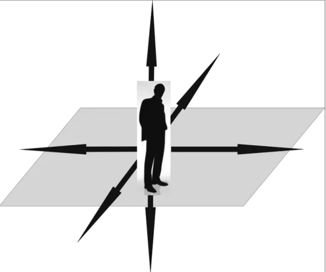
Right from their beginnings, human beings perceived the surrounding space in a way which dif- fered significantly from that of all other terrestrial beings. Writing about this difference, Mircea Eliade noted long time ago that “the upright position [of the human beings] already signals the overcoming of the primates’ condition. We can only stand up when we are awake. Due to the upright position, the space is organized in a structure that is not accessible to the pre-hominids: in four horizontal directions starting from a central up – down axis. In other words, the space is organized around the human body, extending ahead, behind, to the right and the left, up and down. Beginning from this original experience – of being thrown into an environment whose expansion was apparently unlim- ited, unknown and threatening – various manners of orientatio emerged; we cannot live too long with the confusion generated by disorientation (Fig. 1). This experience of the space oriented around a centre is explaining the importance of divisions and the exemplary separation of the territories, settlements and households, and their cosmological symbolism”1 (emphasis added). Accordingly, the organization of space is an inher- ent characteristic of the human (daily) life, and the spatial orientation is facilitated by natural or man- made signs and symbols which are read and understood according to the norms governing the visual language of each community.
* This work was supported by a grant of the Ministry of Research and Innovation, CNCS – UEFISCDI, project number PN-III-P4-ID-PCE–2016-0353, within PNCDI III. It was also supported by the János Bolyai Research Scholarship of the Hungarian Academy of Sciences granted to S. Berecki.
1 ELIADE 1991, p. 13.
66 / Aurel Rustoiu, Sándor Berecki
Fig. 1. M. Eliade: “...the space is organized around the human body, extending ahead, behind, to the right and the left, up and down. Beginning from this original experience... various manners of orientatio emerged”
(drawing A. Rustoiu).
In everyday life, the surrounding space is defined by signs and symbols having various functions:
indicators of location or direction, commercial billboards, public and private constructions, religious signs etc. (Fig. 2). Together they organize the space into a structure that is expressing certain eco- nomic, social or ideological concepts, as well as particular relations of power and subordination or social and cultural identities. For this reason, some anthropological studies as well as others that are dealing with the cultural geography point to the close functional and symbolic connections between the social structures, the systems of authority and the landscape shaping2. One of the relevant indica- tors that define the symbolic relation between landscape and social status or power is the manner of organizing the space both horizontally and vertically3.
Horizontally, many communities organize their space according to the location of the centre of power. The activity of the entire society gravitates around this centre. However, its location is seldom corresponding to the topographic or geographic centre of the territory occupied by the community.
In Plato’s “ideal city-state” the authority represents the focal point of the community, which is sur- rounded by the remaining social layers of the respective society; its ideal “central” location signals the determinant role played by the “philosopher-ruler” in the life of the entire society and not necessarily the topographic organization of the community (Fig. 3/1).
2 A synthesis of the theoretical and methodological approaches regarding landscape analysis in archaeology in SEIBERT 2006; see also ROWNTREE, CONKEY 1980; GREIDER, GARKOVICH 1994; FORSYTH, DRISCOLL 2009.
3 GALVANI, PIRAZZOLI 2013.
Symbols of Status and Power in the Everyday Life of Late Iron Age Transylvania. Shaping the Landscape / 67
Fig. 2. “In everyday life, the surrounding space is defined by signs and symbols having various functions...”. Signs, billboards and public initiatives in the daily urban landscape – Cluj-Mănăştur, Romania (photo A. Rustoiu).
Fig. 3. 1. Organization of the “ideal city-state” according to Plato (drawing A. Rustoiu); 2. The White House and the Kremlin: symbolic centres of power (after Google Images).
At the same time, the centre of power and its visual representation also play an important sym- bolic role in the construction and reiteration of collective identity. For example, exceptional archi- tectural embodiments of power, like the White House in the US or the Kremlin in Russia, are often perceived as shorthand for powerful political entities (Fig. 3/2). Their role as symbols of the centres of power is also expressed in official discourse or public sphere, i.e. “the White House has declared...”
or “the Kremlin has decided...”.
The vertical organization of the space also offers relevant information regarding the nature of power structures in a given society. In highly hierarchic societies there is a tendency to express social inequality and subordination through the vertical manipulation of the landscape. This is the case, for example, of the fortresses made of earth and timber, and then of stone in the medieval times4
4 FORSYTH, DRISCOLL 2009, p. 49 note that in Britain during the second half of the 1st millennium AD “the hillforts
68 / Aurel Rustoiu, Sándor Berecki
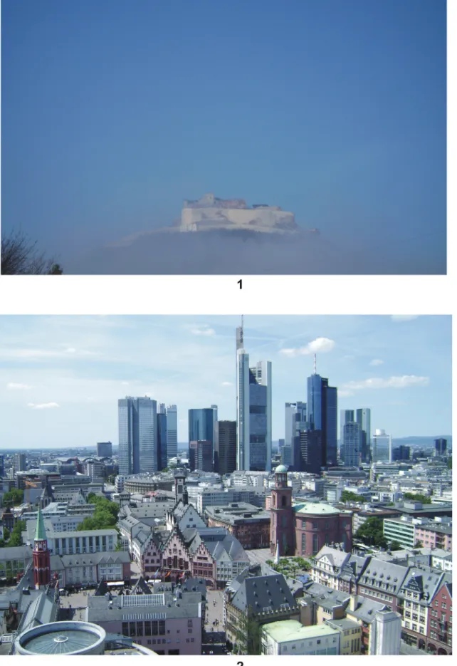
(Fig. 4/1) or of the sky-scrappers from the financial capitals of the modern world5 (Fig. 4/2). These constructions stand out in the surrounding landscape and are meant to express visually and symboli- cally the economic and social power of a restricted group. In “pseudo-egalitarian” societies, like those of the rural communities from Iron Age Europe, or in modern democratic societies, social competi- tion is more often expressed in the public sphere and less likely by manipulating the landscape.
Taking into consideration these general observations, the aim of this article is to discuss the manner in which the Late Iron Age communities from Transylvania organized the space and manipu- lated the landscape, on one hand, and to identify the symbolic relation between these practices and the dynamics of status and power, on the other hand.
Celtic
vS. Dacian Horizon
In this context, it has to be noted that both culturally and historically the Transylvanian Late Iron Age consists of two distinct horizons. The first is the so-called Celtic horizon, between ca. 350 and 175 BC, whereas the second is the so-called Dacian horizon, between ca. 175 BC and AD 1066.
The Celtic horizon was characterized by an exclusively rural way of life. The local communities, each consisting of a reduced number of individuals (ca. 15–25), were divided in family groups or clans7. This pattern can be best observed in the internal organization of the settlements and also in that of some cemeteries8.
In spite of the “pseudo-egalitarian” nature of the respective societies, these clans were appar- ently engaged into a permanent social and economic competition. Sometimes the effects of this com- petition left behind some archaeological traces; for example it can be observed in the layout of the cemetery at Fântânele – Dâmbu Popii (Fig. 5). This cemetery was established by three different fami- lies who divided the funerary ground among themselves. Over time, one of these families expanded its funerary area to the detriment of the other two families. This territorial expansion was more likely the result of a “demographic” increasing within the respective group, leading to a strengthening of its social authority within the entire community. One other argument for this hypothesis is the concen- tration of the graves containing weaponry mostly in the area occupied by this dominant group9.
The internal organization of the settlements reflects a similar social structure of the communi- ties. The dwellings are grouped, with each group located at a certain distance from the others, for example at Ciumeşti or Cicir, or in some settlements from the western Carpathian Basin10 (Fig. 6).
Nevertheless, there are some situations, for example at Moreşti, where this kind of internal organiza- tion is less visible on the plan of the settlement11.
Regarding the geographic position, the rural settlements are surrounded by their agricultural hinterland, being located either on river terraces or in fertile meadows12. Unlike the settlements, the cemeteries usually occupy higher locations in the settlements’ surroundings: hilltops or slopes, higher terraces or ridges etc.13. Among the relevant examples can be mentioned the cemeteries at Aiud, Blandiana or Ciumeşti (Fig. 7). Accordingly, the cemetery of a community is always visible from the settlement and also from the nearby routes of communication and the neighbouring settlements.
can be thought of as ‘proto-castles’, as these fortified elite residences frequently occupied prominent positions of natural strength and visually dominated their hinterland. The use of hilltop fortifications declines during the 9th century, when paradoxically, warfare was at its most intense during the wars of the Viking Age”.
5 See further in GALVANI, PIRAZZOLI 2013.
6 RUSTOIU 2008; RUSTOIU 2015a.
7 KARL 2015, p. 90; RUSTOIU 2016, p. 240–244.
8 RUSTOIU 2016.
9 RUSTOIU 2015a, p. 22–23; RUSTOIU 2016, p. 240.
10 ZIRRA 1980; RUSTOIU 2013; KARL 2015; TREBSCHE 2014 etc.
11 BERECKI 2008.
12 See further in BERECKI 2015.
13 BERECKI 2015.
Symbols of Status and Power in the Everyday Life of Late Iron Age Transylvania. Shaping the Landscape / 69
Fig. 4. In highly hierarchic societies social subordination is also expressed through the vertical organization of the landscape: 1. Medieval fortress at Deva (Romania); 2. Financial power of the
banks illustrated by the sky-scrappers from Frankfurt (Germany) (photo A. Rustoiu).
70 / Aurel Rustoiu, Sándor Berecki
The case of the Celtic cemeteries from the Aiud area, where each funerary ground was visible from the others, is relevant (Fig. 8). Taking into consideration these principles governing the organi- zation of the habitat and the funerary space, one cannot exclude that the respective cemeteries visu- ally signalled the ownership rights of each community over a certain area on the basis of ancestral ties or traditions. Along the same lines, it is probably not a coincidence that many Celtic cemeteries from Transylvania are located in the same areas in which earlier cemeteries were established at the end of the Early Iron Age14. The latter more likely contributed to the construction of new collective identities on the basis of certain myths of origin in the context of Celtic colonization in Transylvania.
Summarising these observations, it is quite clear that the manner in which the surrounding space was organized played an important role in the symbolic reiteration of a rural collective identity of “pseudo-egalitarian” type. Social competition between various clans took place mostly within the public sphere, during communal gatherings or funerals etc and not on the basis of an “ostentatious”
manipulation of the landscape.
This situation had changed significantly during the following period corresponding to the Dacian horizon. In this context, the fortified settlement at Cugir provides a relevant example regarding the manner of organizing the surrounding space15 (Fig. 9/1). The defensive elements consisting of earth ramparts and palisades were erected around a man-made plateau on top of the Cetate hill, having an
14 BERECKI 2014.
15 See further in RUSTOIU 2015b.
Fig. 5. Chronological evolution of the cemetery at Fântânele – Dâmbu Popii. Red: horizon 1 (LT B1/B2). Green: horizon 2 (LT B2a). Blue: horizon 3 (LT B2b). Brown: horizon 4 (LT C1). The cemetery was established by three different families or clans. During the last horizon, the western group had expanded to the detriment of the two other groups (after RUSTOIU 2015a).
Symbols of Status and Power in the Everyday Life of Late Iron Age Transylvania. Shaping the Landscape / 71
Fig. 6. Internal organization of some settlements in group of houses: 1. Cicir, Romania (after RUSTOIU 2013); 2. Göttlesbrunn, Austria (after KARL, PROCHASKA 2005).
72 / Aurel Rustoiu, Sándor Berecki
Fig. 7. Topographic distribution of the cemeteries and settlements at Blandiana (1) and Ciumeşti (2), in Romania (photo and drawings S. Berecki).
Symbols of Status and Power in the Everyday Life of Late Iron Age Transylvania. Shaping the Landscape / 73
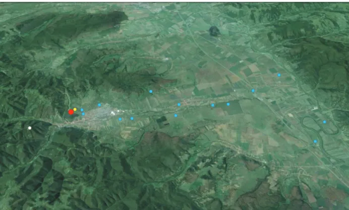
altitude of 495 m. Due to its position, the Cetate hill dominates the surrounding regions along the valley of Cugir River, having a good visibility to the north over the fertile plain extending towards the meadows of the Mureş River (Fig. 9/2). To the south, the landscape is dominated by the heights of the Şureanu Mountains. Numerous dwellings and storage pits have been found inside the fortified enclosure. The habitat areas expanded on the lower terraces of the hill, outside the fortified enclosure.
Aside from the fortified settlement on the Cetate hill, other traces of habitat have been identi- fied during archaeological surveys or as accidental discoveries on the foothills as well as on the terraces of the Cugir River and down to the Mureş valley16. Lastly, traces of habitat dated to the
16 POPA 2004, p. 91–97; POPA 2011, p. 283–298.
Fig. 8. 1. The cemeteries from Aiud region and their visibility areas (image generated using Global Mapper by S. Berecki); 2. The cemeteries at Aiud and Gâmbaş as seen from Sâncrai (photo A. Rustoiu).
74 / Aurel Rustoiu, Sándor Berecki
Fig. 9. 1. Organization of the habitat and funerary space in the settlement at Cugir (1. fortified enclosure; 2.
inhabited terraces outside the fortified enclosure; 3. lower plateau with traces of habitation; 4. Cugir River; 5.
tumulus cemetery seen from the north–south direction; Şureanu Mountains in the background) (after RUSTOIU 2015b; aerial photo Z. Czajlik); 2. Visibility range (red) of the fortified settlement at Cugir (yellow dot), extending northward mainly along the Cugir valley and down to the Mureş valley. The area probably corresponds to the agricultural territory of the community from Cugir (image generated using Global Mapper by S. Berecki).
same period have been identified on Chiciura peak (730 m altitude), southward from the Cetate hill17 (Fig. 10).
Regarding the funerary space, this consists of a small cremation cemetery including four tumuli, which is located on the relatively steep western slope, in the immediate vicinity of the fortified
17 RUSTOIU 2015b.
Symbols of Status and Power in the Everyday Life of Late Iron Age Transylvania. Shaping the Landscape / 75
enclosure and the road leading to the fortress. Three of these burials contained weapons or other elements of military equipment. Tumulus no. 2 contained the richest inventory, pointing to the social importance of the deceased. The inventory, including one panoply of weapons, one chariot, harness fittings, one situla of the Eggers 20 type and other grave-goods, can be dated to the La Tène D1, being contemporaneous with the beginnings of the fortified settlement18.
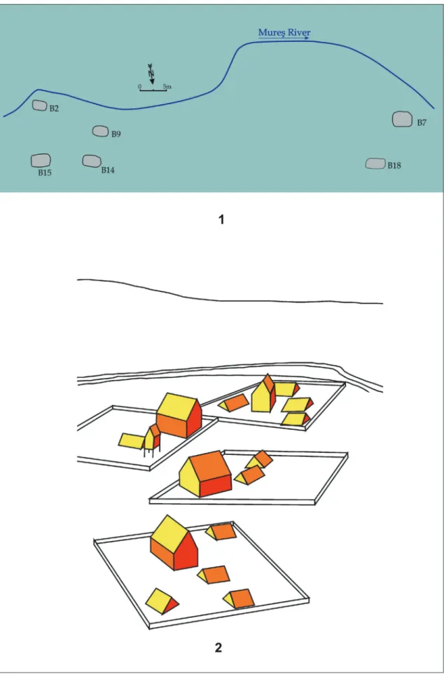
Fig. 10. Horizontal organization, from the south to the north, of the social and economic space of the Dacian community from Cugir. The distribution of rural settlements corresponds to the visibility area from the fortress (see fig. 9/2). Red – fortress; yellow – ancillary settlement; white – observation point or shepherd shelter; blue – rural settlements (drawing A. Rustoiu after POPA 2011).
This cemetery, containing a small number of graves which share the same funerary rite, rituals and inventories, seems to have belonged to a small group of warriors whose identity was primarily expressed by the panoply of weapons (or elements of it) laid into the grave. This manner of express- ing individual identity is specific to the ruling elites of the northern Balkans, the lower Danube area and the Dacian territories inside the Carpathians range (Fig. 11). Due to the chronology of the cem- etery and the fortified settlement, it can be presumed that members of this group were the “founders”
and “rulers” of the fortified settlement and the Dacian community from Cugir.
Accordingly, the organization of the habitat and the funerary space in the fortified settlement at Cugir and in its hinterland differs significantly from the rural model specific to the previous Celtic horizon.
The horizontal organization of the habitat indicates that the fortified settlement was a ‘central place” around which gravitated the ancillary settlement from the vicinity19, as well as those from the agricultural hinterland. The entire economic activity was destined to serve the interests of the fortress and its owners (Fig. 10).
The vertical organization also had significant symbolic implications (Fig. 12). The fortified set- tlement served as residence of the elites ruling over the community from Cugir. Its location on the dominant height, having a wide visibility towards the neighbouring settlements and those from the
18 CRIŞAN 1980; RUSTOIU 2008, p. 161–162; RUSTOIU 2009.
19 For the meaning of “ancillary settlement” in the context of spatial organization of the fortresses from the period of the Dacian Kingdom see EGRI 2014, p. 177.
76 / Aurel Rustoiu, Sándor Berecki
agricultural hinterland reaching the Cugir valley down to the Mureş River, reflects the intention of these elites to indicate their dominating position within the local society. Along the same lines, the fortress served as the visual expression, visible from the distance, of the social status of its owners in relation with the ordinary members of the community and also with the elites of other communities.
A similar example is provided by the medieval fortresses having imposing walls and towers set on top of dominant heights, whose primary scope was to indicate the status of their owners as members of knighthood elites who ruled the European aristocratic realms of the period.
Fig. 11. Distribution map of the graves with weapons specific to the Padea-Panagjurski kolonii group – black dots (after ŁUCZKIEWICZ-SCHÖNFELDER 2008 and RUSTOIU 2015a).
Fig. 12. Vertical organization, from the South to the North, of the social and economic space of the Dacian community from Cugir (after RUSTOIU 2015b).
Symbols of Status and Power in the Everyday Life of Late Iron Age Transylvania. Shaping the Landscape / 77
Regarding the funerary space, the cemetery which more likely belonged to the founding family who ruled over the fortress was established in a highly visible location, close to the fortress and the road leading to its enclosure. At the same time, the tumuli erected over the graves were also visible from the surrounding valleys or the plain. Their presence also indicates the intention to visually sig- nal the social importance of the deceased and their families in relation with all other members of the community. The important social role played by the families of these deceased is also underlined by the funerary rituals performed during the funerals in which more likely most of the community participated.
Accordingly, the organization of the habitat and the funerary spaces in the settlement at Cugir had both a practical, economic scope and also a symbolic one, aiming to serve as a visual expression of the local social hierarchy. The pattern identified at Cugir suggests an interpretative model regard- ing the organization of space and the manipulation of landscape specific to the Dacian chronological and cultural horizon preceding the Roman conquest.
Conclusions
This comparative analysis, which has taken into consideration the manner of organizing the habitat and funerary space and the manipulation of landscape, points to important variations from the Celtic to the Dacian horizon in Transylvania. Among some other things, these elements also served as markers of the manner in which these communities and various groups within them had built and expressed their identity. Accordingly, these variations are the result of significant differ- ences in the social structure and dynamics of the respective societies. These incorporated different social-political, economic and cultural concepts and practices, thus leading to the successive evolu- tion of distinct communal identity constructs inside the Carpathians range during the Late Iron Age.
Bibliography
BERECKI 2008 Berecki S., The La Tène Settlement from Moreşti, Cluj-Napoca.
BERECKI 2014 Berecki S., The coexistence and interference of the Late Iron Age Transylvanian communities, in Popa C. N., Stoddart S. (eds), Fingerprinting the Iron Age. Approaches to identity in the European Iron Age. Integrating South-Eastern Europe into the debate, Oxford, p. 11–17.
BERECKI 2015 Berecki S., Iron Age Settlement Patterns and Funerary Landscapes in Transylvania (4th – 2nd Centuries BC), Târgu Mureş.
CRIŞAN 1980 Crişan I. H., Necropola dacică de la Cugir. Consideraţii preliminare, in Apulum 18, p. 81–87.
EGRI 2014 Egri M., Enemy at the gates? The interactions between Dacians and Romans in the 1st century AD, in Janković M. A., Mihajlović V. D., Babić S. (eds), The edges of the Roman World, Newcastle, p. 172–193.
ELIADE 1991 Eliade M., Istoria credinţelor şi ideilor religioase, Bucureşti.
FORSYTH, DRISCOLL 2009
Forsyth K., Driscoll, S. T., Symbols of power in Ireland and Scotland, 8th–10th century, in Territorio, Sociedad y Poder 2, p. 31–66.
GALVANI, PIRAZZOLI 2013
Galvani A., Pirazzoli R., Landscape as a symbol of power: the high/low marker, in Observatorio Medioambiental 16, p. 99–126.
GREIDER, GARKOVICH 1994
Greider T., Garkovich L., Landscapes: the social construction of nature and environment, in Rural Sociology 59, 1, p. 1–24.
KARL 2015 Karl R., Die mittellatènezeitliche Siedlung von Göttlesbrunn, p. B. Bruck/Leitha, Niederösterreich, in Doneus M., Griebl M. (eds), Die Leitha – Facetten einer Landschaft, Archäologie Österreichs Spezial 3, Wien, p. 85–91.
78 / Aurel Rustoiu, Sándor Berecki
KARL, PROCHASKA 2005
Karl R., Prochaska S., Die latènezeitliche Siedlung von Göttlesbrunn, p. B. Bruck an der Leitha, Niederösterreich. Die Notbergung 1989. Die Grabungen 1992–1994. Zwei latènezeitliche Töpferöfen. Historica Austria 6, Wien.
ŁUCZKIEWICZ, SCHÖNFELDER 2008
Łuczkiewicz P., Schönfelder M., Untersuchungen zur Ausstattung eines späteisen- zeitlichen Reiterkriegers aus dem südlichen Karpaten- oder Balkanraum, in Jahrbuch des Römisch-Germanischen Zentralmuseums Mainz 55, p. 159–210.
POPA 2004 Popa C. I., Descoperiri dacice pe valea Cugirului, in Pescaru A., Ferencz I. V. (eds), Daco-geţii. 80 de ani de cercetări arheologice sistematice la cetăţile dacice din Munţii Orăştiei, Deva, p. 83–166.
POPA 2011 Popa C. I., Valea Cugirului din preistorie până în zorii epocii moderne, Cluj Napoca.
ROWNTREE, CONKEY 1980
Rowntree L. B., Conkey M. W., Symbolism and the cultural landscape, in Ann Am Assoc Geogr 70, 4, p. 459–474.
RUSTOIU 2008 Rustoiu A., Războinici şi societate în aria celtică transilvăneană. Studii pe marginea mormântului cu coif de la Ciumeşti, Cluj-Napoca.
RUSTOIU 2009 Rustoiu A., A Late Republican bronze situla (Eggers type 20) from Cugir (Alba County), Romania, in Instrumentum 29, p. 33–34.
RUSTOIU 2013 Rustoiu A., Celtic lifestyle – indigenous fashion. The tale of an Early Iron Age brooch from the north-western Balkans, in ArchBulg 17, 3, p. 1–16.
RUSTOIU 2015a Rustoiu A., The Celtic horizon in Transylvania. Archaeological and historical evidence, in Berecki S. (ed.), Iron Age Settlement Patterns and Funerary Landscapes in Transylvania (4th – 2nd Centuries BC), Târgu Mureş, p. 9–29.
RUSTOIU 2015b Rustoiu A., Civilian and funerary space in the Dacian fortified settlement at Cugir, in Forţiu S., Stavilă A. (eds), Arheovest III. 1, Interdisciplinarity in Archaeology and History. In Memoriam Florin Medeleţ (1943–2005), Szeged, p. 349–367.
RUSTOIU 2016 Rustoiu A., Some questions regarding the chronology of La Tène cemeteries from Transylvania.
Social and demographic dynamics in the rural communities, in Berecki S. (ed.), Iron Age Chronology in the Carpathian Basin. Proceedings of the international colloquium from Târgu Mureş 8–10 October 2015, Cluj-Napoca, p. 235–264.
SEIBERT 2006 Seibert J. D., Introduction, in Robertson E. C., Seibert J. D., Fernandez D. C., Zender M. U. (eds), Space and spatial analysis in archaeology, Calgary – New Mexico, p. xiii-xxiv.
TREBSCHE 2014 Trebsche P., Size and economic structure of La Tène period lowland settlements in the Austrian Danube region, in Hornung S. (ed.), Produktion – Distribution – Ökonomie.
Siedlungs- und Wirtschaftsmuster der Latènezeit. Akten des internationalen Kolloquiums in Otzenhausen, 28.–30. Oktober 2011, Bonn, p. 341–373.
ZIRRA 1980 Zirra V., Locuiri din a doua vârstă a fierului în nord-vestul României (Aşezarea contem- porană cimitirului La Tène de la Ciumeşti şi habitatul indigen de la Berea), in StCom Satu Mare 4, p. 39–84.